A parkway is a landscaped thoroughfare. The term is particularly used for a roadway in a park or connecting to a park from which trucks and other heavy vehicles are excluded.

The Blue Ridge Parkway is a National Parkway and All-American Road in the United States, noted for its scenic beauty. The parkway, which is America's longest linear park, runs for 469 miles (755 km) through 29 Virginia and North Carolina counties, linking Shenandoah National Park to Great Smoky Mountains National Park. It runs mostly along the spine of the Blue Ridge, a major mountain chain that is part of the Appalachian Mountains. Its southern terminus is at U.S. Route 441 (US 441) on the boundary between Great Smoky Mountains National Park and the Qualla Boundary of the Eastern Band of Cherokee Indians in North Carolina, from which it travels north to Shenandoah National Park in Virginia. The roadway continues through Shenandoah as Skyline Drive, a similar scenic road which is managed by a different National Park Service unit. Both Skyline Drive and the Virginia portion of the Blue Ridge Parkway are part of Virginia State Route 48 (SR 48), though this designation is not signed.

The Natchez Trace Parkway is a national parkway in the Southeastern United States that commemorates the historic Natchez Trace and preserves sections of that original trail. Its central feature is a two-lane road that extends 444 miles (715 km) from Natchez, Mississippi, to Nashville, Tennessee. Access to the parkway is limited, with more than 50 access points in Mississippi, Alabama, and Tennessee. The southern end of the route is in Natchez at its intersection with Liberty Road, and the northern end is northeast of Fairview, Tennessee, in the suburban community of Pasquo, at an intersection with Tennessee State Route 100. In addition to Natchez and Nashville, larger cities along the route include Jackson and Tupelo, Mississippi, and Florence, Alabama.

The Beartooth Highway is an All-American Road in the western United States on a section of U.S. Route 212 in Montana and Wyoming between Red Lodge and the Northeast entrance of Yellowstone National Park. It crests at Beartooth Pass in Wyoming at 10,947 feet (3,337 m) above sea level, and was called "the most beautiful drive in America," by late CBS News correspondent Charles Kuralt. Because of heavy snowfall at the top, the pass is usually open for about five months per year, from mid-May to mid-October, weather conditions permitting.

A National Scenic Byway is a road recognized by the United States Department of Transportation for one or more of six "intrinsic qualities": archeological, cultural, historic, natural, recreational, and scenic. The program was established by Congress in 1991 to preserve and protect the nation's scenic but often less-traveled roads and promote tourism and economic development. The National Scenic Byways Program (NSBP) is administered by the Federal Highway Administration (FHWA).

The National Trails System is a series of trails in the United States designated "to promote the preservation of, public access to, travel within, and enjoyment and appreciation of the open-air, outdoor areas and historic resources of the Nation". There are four types of trails: the national scenic trails, national historic trails, national recreation trails, and connecting or side trails. The national trails provide opportunities for hiking and historic education, as well as horseback riding, biking, camping, scenic driving, water sports, and other activities. The National Trails System consists of 11 national scenic trails, 21 national historic trails, over 1,300 national recreation trails, and seven connecting and side trails, as well as one national geologic trail, with a total length of more than 91,000 mi (150,000 km). The scenic and historic trails are in every state, and Virginia and Wyoming have the most running through them, with six.

The Natchez Trace Trail is a designated National Scenic Trail in the United States, whose route generally follows sections of the 444-mile (715 km) Natchez Trace Parkway through the states of Tennessee, Alabama, and Mississippi. The Natchez Trace Trail is not a long, continuous footpath, as is the case with other national scenic trails ; rather, only a limited number of trail segments along the route, currently over 60 miles (97 km) of trail, have been developed for hiking and horseback riding. Moreover, the Natchez Trace Trail, unlike many others that rely heavily on volunteers for trail construction and maintenance, is managed and maintained by the National Park Service. Sections of the trail follow along the Natchez Trace Parkway road shoulder, and cross county and state roads. It was originally intended to be longer and follow most of the Natchez Trace Parkway, but only portion was built.

Colonial Parkway is a 23-mile (37 km) scenic parkway linking the three points of Virginia's Historic Triangle, Jamestown, Williamsburg, and Yorktown. It is part of the National Park Service's Colonial National Historical Park. Virginia's official state classification for the parkway is State Route 90003. With portions built between 1930 and 1957, it links the three communities via a roadway shielded from views of commercial development. The roadway is toll-free, is free of semi trucks, and has speed limits of around 35 to 45 mph. As a National Scenic Byway and All-American Road, it is also popular with tourists due to the James River and York River ends of the parkway.
Skyline Drive is a 105-mile (169 km) National Parkway that runs the entire length of the National Park Service's Shenandoah National Park in the Blue Ridge Mountains of Virginia, generally along the ridge of the mountains. The drive's northern terminus is at an intersection with U.S. Route 340 (US 340) near Front Royal, and the southern terminus is at an interchange with US 250 near Interstate 64 (I-64) in Rockfish Gap, where the road continues south as the Blue Ridge Parkway. The road has intermediate interchanges with US 211 in Thornton Gap and US 33 in Swift Run Gap. Skyline Drive is part of Virginia State Route 48, which also includes the Virginia portion of the Blue Ridge Parkway, but this designation is not signed.
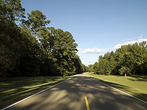
The George Washington Memorial Parkway, colloquially the G.W. Parkway, is a 25-mile-long (40 km) parkway that runs along the south bank of the Potomac River from Mount Vernon, Virginia, northwest to McLean, Virginia, and is maintained by the National Park Service (NPS). It is located almost entirely within Virginia, except for a short portion of the parkway northwest of the Arlington Memorial Bridge that passes over Columbia Island within the District of Columbia.

Virginia State Route 110 (SR 110) is a primary state highway in Arlington, Virginia. Known as the Richmond Highway, the state highway runs 2.41 miles (3.88 km) from U.S. Route 1 (US 1) and Interstate 395 (I-395) in Crystal City north to I-66 in the Rosslyn neighborhood. SR 110 is a four- to six-lane freeway that parallels the Potomac River, providing a connection between several of Arlington's urban villages and major landmarks, including the Pentagon, which is the headquarters of the United States Department of Defense, and the grounds of Arlington National Cemetery. The highway also provides access to SR 27, an east–west freeway between the Pentagon and the cemetery, and the George Washington Parkway that parallels the Potomac River. SR 110 is a part of the National Highway System for its entire length.
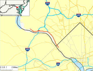
Clara Barton Parkway is an automobile parkway in the U.S. state of Maryland and the District of Columbia. The highway runs 6.8 miles (10.9 km) from MacArthur Boulevard in Carderock, Maryland, east to Canal Road at the Chain Bridge in Washington. Clara Barton Parkway is a two- to four-lane parkway that parallels the Potomac River and the Chesapeake and Ohio Canal (C&O) in southwestern Montgomery County, Maryland, and the far western corner of Washington. The parkway provides access to the communities of Cabin John and Glen Echo and several units of the Chesapeake and Ohio Canal National Historical Park. The Maryland portion of the George Washington Memorial Parkway was constructed from Carderock past Interstate 495 (I-495) to Glen Echo in the early to mid-1960s. The parkway was proposed to continue west to Great Falls and east to Georgetown. However, these proposals never came to fruition and the parkway was extended only to the Chain Bridge in the early 1970s. The Maryland portion of the George Washington Memorial Parkway was renamed in 1989 for Clara Barton, the founder of the American Red Cross, and whose original headquarters is located in Glen Echo.

Transportation in the Commonwealth of Virginia is by land, sea and air. Virginia's extensive network of highways and railroads were developed and built over a period almost 400 years, beginning almost immediately after the founding of Jamestown in 1607, and often incorporating old established trails of the Native Americans.

A greenway is usually a shared-use path along a strip of undeveloped land, in an urban or rural area, set aside for recreational use or environmental protection. Greenways are frequently created out of disused railways, canal towpaths, utility company rights of way, or derelict industrial land. Greenways can also be linear parks, and can serve as wildlife corridors. The path's surface may be paved and often serves multiple users: walkers, runners, bicyclists, skaters and hikers. A characteristic of greenways, as defined by the European Greenways Association, is "ease of passage": that is that they have "either low or zero gradient", so that they can be used by all "types of users, including mobility impaired people".

Eastern Parkway is a major road that runs through a portion of the New York City borough of Brooklyn. Designed by Frederick Law Olmsted and Calvert Vaux, it was the world's first parkway, having been built between 1870 and 1874. At the time of its construction, Eastern Parkway went to the eastern edge of Brooklyn, hence its name.

Arborway consists of a four-lane, divided parkway and a two lane residential street in the Jamaica Plain neighborhood of Boston, Massachusetts, United States. It was designed by Frederick Law Olmsted in the 1890s as the south most carriage road in a series of parkways connecting parks from Boston Common in downtown Boston to Franklin Park in Roxbury. This park system has since become known as the Emerald Necklace of Boston.

Mission 66 was a United States National Park Service ten-year program that was intended to dramatically expand Park Service visitor services by 1966, in time for the 50th anniversary of the establishment of the Park Service.
Since 1872 the United States National Park System has grown from a single, public reservation called Yellowstone National Park to include 430 natural, historical, recreational, and cultural areas throughout the United States, its territories, and island possessions. These areas include National Parks, National Monuments, National Memorials, National Military Parks, National Historic Sites, National Parkways, National Recreation Areas, National Seashores, National Scenic Riverways, and National Scenic Trails.

A scenic route, tourist road, tourist route, tourist drive, holiday route, theme route, or scenic byway is a specially designated road or waterway that travels through an area of natural or cultural beauty. It often passes by scenic viewpoints. The designation is usually determined by a governmental body, such as a Department of Transportation or a Ministry of Transport.
Minnesota Scenic Byways are a system of roads in the U.S. state of Minnesota which pass through areas of scenic, cultural, or recreational significance. There are currently 22 scenic byways in the system with a total length of 2,948 miles (4,744 km). Eight of these byways are also designated as National Scenic Byways, and the North Shore Scenic Drive is further designated as an All-American Road.