
U.S. Route 3 (US 3) is a United States Numbered Highway running 277.90 miles (447.24 km) from Cambridge, Massachusetts, through New Hampshire, to the Canada–United States border near Third Connecticut Lake, where it connects to Quebec Route 257.
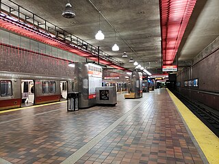
Alewife station is a Massachusetts Bay Transportation Authority (MBTA) intermodal transit station in the North Cambridge neighborhood of Cambridge, Massachusetts. It is the northwest terminal of the rapid transit Red Line and a hub for several MBTA bus routes. The station is at the confluence of the Minuteman Bikeway, Alewife Linear Park, Fitchburg Cutoff Path, and Alewife Greenway off Alewife Brook Parkway adjacent to Massachusetts Route 2, with a five-story parking garage for park and ride use. The station has three bike cages. Alewife station is named after nearby Alewife Brook Parkway and Alewife Brook, themselves named after the alewife fish.

Route 2 is a 142.29-mile-long (228.99 km) major east–west state highway in Massachusetts, United States. Along with Route 9 and U.S. Route 20 to the south, these highways are the main alternatives to the Massachusetts Turnpike/I-90 toll highway. Route 2 runs the entire length of the northern tier of Massachusetts, beginning at the New York border, where it connects with New York State Route 2, and ending near Boston Common in Boston. Most of the route is an expressway through the northern tier of Massachusetts, with the longest surface road segments being the western portion. Older alignments of Route 2 are known as Route 2A.

The Middlesex Canal was a 27-mile (44-kilometer) barge canal connecting the Merrimack River with the port of Boston. When operational it was 30 feet wide, and 3 feet deep, with 20 locks, each 80 feet long and between 10 and 11 feet wide. It also had eight aqueducts.

The Department of Conservation and Recreation (DCR) is a state agency of the Commonwealth of Massachusetts, United States, situated in the Executive Office of Energy and Environmental Affairs. It is best known for its parks and parkways. The DCR's mission is "To protect, promote and enhance our common wealth of natural, cultural and recreational resources for the well-being of all." The agency is the largest landowner in Massachusetts.

Middlesex Fells Reservation, often referred to simply as the Fells, is a public recreation area covering more than 2,200 acres (890 ha) in Malden, Medford, Melrose, Stoneham, and Winchester, Massachusetts, United States. The state park surrounds two inactive reservoirs, Spot Pond and the Fells Reservoir, and the three active reservoirs that are part of the water supply system for the town of Winchester. Spot Pond and the Fells Reservoir are part of the Wachusett water system, one of six primary water systems that feed metropolitan Boston's waterworks. The park is managed by the Massachusetts Department of Conservation and Recreation and is part of the Metropolitan Park System of Greater Boston.

Revere Beach Parkway is a historic parkway in the suburbs immediately north of Boston, Massachusetts. It begins at Wellington Circle in Medford, where the road leading to the west is Mystic Valley Parkway, and the north–south road is the Fellsway, designated Route 28. The parkway proceeds east, ending at Eliot Circle, the junction of Revere Beach Boulevard and Winthrop Parkway in Revere. In between, the parkway passes through the cities of Everett and Chelsea. The parkway was built between 1896 and 1904 to provide access from interior communities to Revere Beach. It underwent two major periods of capacity expansion, in the 1930s and again in the 1950s. The parkway is designated as part of Route 16 west of Route 1A, and as part of Route 145 east of that point.

Alewife Brook Reservation is a Massachusetts state park and urban wild located in Cambridge, Arlington, and Somerville. The park is managed by the state Department of Conservation and Recreation and was established in 1900. It is named for Alewife Brook, which was also historically known as Menotomy River, a tributary of the Mystic River.

This is a list of properties and districts in Massachusetts listed on the National Register of Historic Places. There are over 4,300 listings in the state, representing about 5% of all NRHP listings nationwide and the second-most of any U.S. state, behind only New York. Listings appear in all 14 Massachusetts counties.

Route 38 is a state highway in the U.S. state of Massachusetts, traveling 26.5 miles (42.6 km) from Route 28 in Somerville north via Lowell to the New Hampshire state line in Dracut, where it continues as New Hampshire Route 38 in Pelham, New Hampshire. Although its southern terminus is at Route 28, some signage indicates that Route 38 continues south towards Sullivan Square in Boston.
Alewife Brook Parkway is a short parkway in Cambridge and Somerville, Massachusetts. It is listed on the National Register of Historic Places. It begins at Fresh Pond in Cambridge, and heads north on the east bank of Alewife Brook, crossing into West Somerville and ending at the Mystic River on the Medford town line, where it becomes Mystic Valley Parkway. The entire length of Alewife Brook Parkway is designated as part of Massachusetts Route 16 (Route 16), while the southernmost sections are also designated as part of Route 2 and U.S. Route 3 (US 3). It is managed by the Department of Conservation and Recreation with the Massachusetts Department of Transportation responsible for bridge maintenance.

Lynn Fells Parkway is a parkway in Greater Boston, Massachusetts, in the United States. It is maintained by the Massachusetts Department of Conservation and Recreation. The road runs from the end of Fellsway East in Stoneham, eastward through Melrose, and ends in Saugus at US Route 1. The parkway serves as a connector between the Middlesex Fells Reservation and Breakheart Reservation.
Fresh Pond Parkway is a historic park and parkway on the western end of Cambridge, Massachusetts, part of the Metropolitan Park System of Greater Boston. The parkway was built in 1899 and added to the National Register of Historic Places in 2005.

The Fells Connector Parkways are a group of historic parkways in the cities of Malden and Medford, Massachusetts, suburbs north of the city of Boston. The three parkways, The Fellsway, Fellsway West, and Fellsway East serve to provide access from the lower portion of the Mystic River Reservation to the Middlesex Fells Reservation. The latter two parkways continue northward, providing access to the interior of the Fells and providing a further connection to Lynn Fells Parkway. Significant portions of these parkways south of the Fells, which were among the first connecting parkways designed to be part of the Metropolitan Park System of Greater Boston by Charles Eliot, were listed on the National Register of Historic Places in 2003.

The Charles River Reservation Parkways are parkways that run along either side of the Charles River in eastern Massachusetts. The roads are contained within the Charles River Reservation and the Upper Charles River Reservation, and fall within a number of communities in the greater Boston metropolitan area. The Charles River parks extend from the Charles River Dam, where the Charles empties into Boston Harbor, to Riverdale Park in the West Roxbury neighborhood of Boston. Most of the roadways within the parks are listed on the National Register of Historic Places as a unit, although Storrow Drive and Memorial Drive are listed as part of the Charles River Basin Historic District.

The Middlesex Fells Reservation Parkways are the roadways within and bordering on the Middlesex Fells Reservation, a state park in the northern suburbs of Boston, Massachusetts, United States. The park includes portions of the towns of Malden, Medford, Melrose, Stoneham, and Winchester. The roads inside the park and around its perimeter have been listed on the National Register of Historic Places. Other portions of some of the roads are covered by more than one listing in the national register; see Fellsway Connector Parkways and Middlesex Fells Reservoirs Historic District.

Furnace Brook Parkway is a historic parkway in Quincy, Massachusetts. Part of the Metropolitan Park System of Greater Boston, it serves as a connector between the Blue Hills Reservation and Quincy Shore Reservation at Quincy Bay. First conceived in the late nineteenth century, the state parkway is owned and maintained by the Massachusetts Department of Conservation and Recreation (DCR) and travels through land formerly owned by the families of John Adams and John Quincy Adams, passing several historic sites. It ends in the Merrymount neighborhood, where Quincy was first settled by Europeans in 1625 by Captain Richard Wollaston. The road was started in 1904, completed in 1916 and added to the National Register of Historic Places (NRHP) in 2004.

The Mystic River Reservation is a publicly owned nature preserve with recreational features located along the Mystic River in the towns of Winchester, Arlington, Medford, Somerville, Everett, and Chelsea in eastern Massachusetts. The reserve is part of the nearly 76-square-mile (200 km2) Mystic River watershed. It is managed by the Massachusetts Department of Conservation and Recreation.
Route 16 is a 59.8646-mile-long (96.3427 km) east–west state highway in Massachusetts. It begins in the west at an intersection with Route 12 and Route 193 in Webster, just north of the Connecticut state border. It runs in a generally southwest-northeast routing through a number of Boston's suburbs and runs to the west and then north of the city before ending in Revere at an intersection with Route 1A and Route 60.
Mystic Valley Parkway station is a proposed light rail station on the MBTA Green Line in Somerville, Massachusetts; it would be built as part of a future third phase of the Green Line Extension (GLX). Route 16 would consist of one island platform, which would serve the E branch's two tracks.


