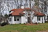
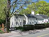
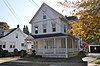
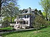
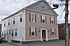
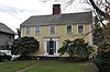
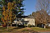
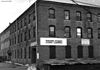
[3] Name on the Register Image Date listed [4] Location City or town Description 1 Beacon Street Tomb Beacon Street Tomb July 6, 1989 (# 89000714 Beacon St. 42°30′35″N 71°04′50″W / 42.5097°N 71.0806°W / 42.5097; -71.0806 (Beacon Street Tomb ) 2 Beebe Homestead Beebe Homestead July 6, 1989 (# 89000667 142 Main St. 42°31′01″N 71°04′28″W / 42.5169°N 71.0744°W / 42.5169; -71.0744 (Beebe Homestead ) 3 E. Boardman House E. Boardman House July 6, 1989 (# 89000686 34 Salem St. 42°30′31″N 71°04′07″W / 42.5086°N 71.0686°W / 42.5086; -71.0686 (E. Boardman House ) 4 Elizabeth Boit House Elizabeth Boit House July 6, 1989 (# 89000720 127 Chestnut St. 42°30′11″N 71°05′11″W / 42.5031°N 71.0864°W / 42.5031; -71.0864 (Elizabeth Boit House ) 5 Breakheart Reservation Parkways-Metropolitan Park System of Greater Boston Breakheart Reservation Parkways-Metropolitan Park System of Greater Boston August 11, 2003 (# 03000748 Forest St., Pine Tops, Elm and Hemlock Rds. 42°29′15″N 71°02′05″W / 42.4875°N 71.0347°W / 42.4875; -71.0347 (Breakheart Reservation Parkways-Metropolitan Park System of Greater Boston ) Extends into Saugus in Essex County . 6 Buildings at 35–37 Richardson Avenue Buildings at 35–37 Richardson Avenue July 6, 1989 (# 89000710 35–37 Richardson Ave. 42°30′08″N 71°04′24″W / 42.5022°N 71.0733°W / 42.5022; -71.0733 (Buildings at 35–37 Richardson Avenue ) 7 Building at 38–48 Richardson Avenue Building at 38–48 Richardson Avenue July 6, 1989 (# 89000709 38–48 Richardson Ave. 42°30′05″N 71°04′30″W / 42.5014°N 71.075°W / 42.5014; -71.075 (Building at 38–48 Richardson Avenue ) 8 Center Depot Center Depot July 6, 1989 (# 89000693 57 Water St. 42°30′09″N 71°04′05″W / 42.5025°N 71.0681°W / 42.5025; -71.0681 (Center Depot ) 9 Church-Lafayette Streets Historic District Church-Lafayette Streets Historic District July 6, 1989 (# 89000757 Roughly Church St. from Lafayette St. to North Ave. 42°30′20″N 71°04′38″W / 42.5056°N 71.0771°W / 42.5056; -71.0771 (Church-Lafayette Streets Historic District ) 10 Common District Common District March 2, 1990 (# 89000754 Roughly bounded by Lake Quannapowitt, Main St., Common St., Church St., and Lake Ave. 42°30′23″N 71°04′23″W / 42.5064°N 71.0731°W / 42.5064; -71.0731 (Common District ) 11 Jonas Cowdry House Jonas Cowdry House July 6, 1989 (# 89000739 61 Prospect St. 42°30′18″N 71°05′08″W / 42.505°N 71.0856°W / 42.505; -71.0856 (Jonas Cowdry House ) 12 Nathaniel Cowdry House Nathaniel Cowdry House July 6, 1989 (# 89000738 71 Prospect St. 42°30′17″N 71°05′10″W / 42.5047°N 71.0861°W / 42.5047; -71.0861 (Nathaniel Cowdry House ) 13 Emerson-Franklin Poole House Emerson-Franklin Poole House July 6, 1989 (# 89000685 23 Salem St. 42°30′31″N 71°04′10″W / 42.5086°N 71.0694°W / 42.5086; -71.0694 (Emerson-Franklin Poole House ) 14 Flanley's Block Flanley's Block July 6, 1989 (# 89000729 349–353 Main St. 42°30′16″N 71°04′19″W / 42.5044°N 71.0719°W / 42.5044; -71.0719 (Flanley's Block ) 15 Captain Goodwin-James Eustis House Captain Goodwin-James Eustis House March 2, 1990 (# 89000744 1 Elm St. 42°30′21″N 71°04′52″W / 42.5058°N 71.0811°W / 42.5058; -71.0811 (Captain Goodwin-James Eustis House ) Misspelled "Custis" in the National Register listing. 16 Samuel Gould House Samuel Gould House July 6, 1989 (# 89000704 48 Meriam St. 42°29′10″N 71°04′12″W / 42.4861°N 71.07°W / 42.4861; -71.07 (Samuel Gould House ) 17 Green House Green House March 9, 1990 (# 90000185 391 Vernon St. 42°31′23″N 71°03′53″W / 42.523°N 71.0647°W / 42.523; -71.0647 (Green House ) Duplicate listing for Capt. William Green House. 18 Capt. William Green House Capt. William Green House July 6, 1989 (# 89000672 391 Vernon St. Duplicate listing for Green House. 19 Deacon Daniel Green House Deacon Daniel Green House July 6, 1989 (# 89000706 747 Main St. 42°29′29″N 71°04′10″W / 42.4914°N 71.0694°W / 42.4914; -71.0694 (Deacon Daniel Green House ) 20 Greenwood Union Church Greenwood Union Church July 6, 1989 (# 89000697 Main and Oak 42°28′57″N 71°04′00″W / 42.4825°N 71.0667°W / 42.4825; -71.0667 (Greenwood Union Church ) 21 House at 18A and 20 Aborn Street House at 18A and 20 Aborn Street July 6, 1989 (# 89000676 18A and 20 Aborn St. 42°30′45″N 71°04′20″W / 42.5125°N 71.0722°W / 42.5125; -71.0722 (House at 18A and 20 Aborn Street ) 22 House at 6 Adams Street House at 6 Adams Street July 6, 1989 (# 89000721 6 Adams St. 42°30′07″N 71°05′13″W / 42.5019°N 71.0869°W / 42.5019; -71.0869 (House at 6 Adams Street ) 23 House at 380 Albion Street House at 380 Albion Street July 6, 1989 (# 89000711 380 Albion St. 42°29′32″N 71°05′08″W / 42.4922°N 71.0856°W / 42.4922; -71.0856 (House at 380 Albion Street ) 24 House at 23 Avon Street House at 23 Avon Street July 6, 1989 (# 89000730 23 Avon St. 42°30′15″N 71°04′26″W / 42.5042°N 71.0739°W / 42.5042; -71.0739 (House at 23 Avon Street ) 25 House at 25 Avon Street House at 25 Avon Street July 6, 1989 (# 89000731 25 Avon St. 42°30′15″N 71°04′29″W / 42.5042°N 71.0747°W / 42.5042; -71.0747 (House at 25 Avon Street ) 26 House at 5 Bennett Street House at 5 Bennett Street July 6, 1989 (# 89000698 5 Bennett St. 42°29′59″N 71°04′10″W / 42.4997°N 71.0694°W / 42.4997; -71.0694 (House at 5 Bennett Street ) 27 House at 15 Chestnut Street House at 15 Chestnut Street July 6, 1989 (# 89000726 15 Chestnut St. 42°30′13″N 71°04′26″W / 42.5036°N 71.0739°W / 42.5036; -71.0739 (House at 15 Chestnut Street ) 28 House at 21 Chestnut Street House at 21 Chestnut Street July 6, 1989 (# 89000727 21 Chestnut St. 42°30′12″N 71°04′29″W / 42.5033°N 71.0747°W / 42.5033; -71.0747 (House at 21 Chestnut Street ) 29 House at 95 Chestnut Street House at 95 Chestnut Street July 6, 1989 (# 89000725 95 Chestnut St. 42°30′06″N 71°05′00″W / 42.5017°N 71.0833°W / 42.5017; -71.0833 (House at 95 Chestnut Street ) 30 House at 39 Converse Street House at 39 Converse Street July 6, 1989 (# 89000718 39 Converse St. 42°29′59″N 71°05′09″W / 42.4997°N 71.0858°W / 42.4997; -71.0858 (House at 39 Converse Street ) 31 House at 28 Cordis Street House at 28 Cordis Street July 6, 1989 (# 89000675 28 Cordis St. 42°30′55″N 71°04′19″W / 42.5153°N 71.0719°W / 42.5153; -71.0719 (House at 28 Cordis Street ) 32 House at 40 Crescent Street House at 40 Crescent Street July 6, 1989 (# 89000691 40 Crescent St. 42°30′13″N 71°04′08″W / 42.5036°N 71.0689°W / 42.5036; -71.0689 (House at 40 Crescent Street ) 33 House at 26 Francis Avenue House at 26 Francis Avenue July 6, 1989 (# 89000701 26 Francis Ave. 42°29′00″N 71°03′46″W / 42.4833°N 71.0628°W / 42.4833; -71.0628 (House at 26 Francis Avenue ) 34 House at 118 Greenwood Street House at 118 Greenwood Street July 6, 1989 (# 89000702 118 Greenwood St. 42°28′28″N 71°04′12″W / 42.4744°N 71.07°W / 42.4744; -71.07 (House at 118 Greenwood Street ) 35 House at 20 Hancock Road House at 20 Hancock Road July 6, 1989 (# 89000671 20 Hancock Rd. 42°31′05″N 71°04′25″W / 42.5181°N 71.0736°W / 42.5181; -71.0736 (House at 20 Hancock Road ) 36 House at 42 Hopkins Street House at 42 Hopkins Street July 6, 1989 (# 89000732 42 Hopkins St. 42°30′13″N 71°05′48″W / 42.5036°N 71.0967°W / 42.5036; -71.0967 (House at 42 Hopkins Street ) 37 House at 15 Lawrence Avenue House at 15 Lawrence Avenue July 6, 1989 (# 89000682 15 Lawrence Ave. 42°30′37″N 71°04′14″W / 42.5103°N 71.0706°W / 42.5103; -71.0706 (House at 15 Lawrence Avenue ) 38 House at 20 Lawrence Street House at 20 Lawrence Street July 6, 1989 (# 89000680 20 Lawrence St. 42°30′36″N 71°04′11″W / 42.51°N 71.0697°W / 42.51; -71.0697 (House at 20 Lawrence Street ) 39 House at 23 Lawrence Street House at 23 Lawrence Street July 6, 1989 (# 89000681 23 Lawrence St. 42°30′40″N 71°04′10″W / 42.5111°N 71.0694°W / 42.5111; -71.0694 (House at 23 Lawrence Street ) 40 House at 556 Lowell Street House at 556 Lowell Street July 6, 1989 (# 89000670 556 Lowell St. 42°30′55″N 71°03′05″W / 42.5153°N 71.0514°W / 42.5153; -71.0514 (House at 556 Lowell Street ) 41 House at 190 Main Street House at 190 Main Street July 6, 1989 (# 89000666 190 Main St. 42°30′49″N 71°04′27″W / 42.5136°N 71.0742°W / 42.5136; -71.0742 (House at 190 Main Street ) 42 House at 196 Main Street House at 196 Main Street July 6, 1989 (# 89000668 196 Main St. 42°30′47″N 71°04′27″W / 42.5131°N 71.0742°W / 42.5131; -71.0742 (House at 196 Main Street ) 43 House at 1 Morrison Avenue House at 1 Morrison Avenue July 6, 1989 (# 89000722 1 Morrison Ave. 42°30′03″N 71°05′18″W / 42.5008°N 71.0883°W / 42.5008; -71.0883 (House at 1 Morrison Avenue ) 44 House at 20 Morrison Road House at 20 Morrison Road July 6, 1989 (# 89000724 20 Morrison Rd. 42°30′05″N 71°05′25″W / 42.5014°N 71.0903°W / 42.5014; -71.0903 (House at 20 Morrison Road ) 45 House at 32 Morrison Road House at 32 Morrison Road July 6, 1989 (# 89000723 32 Morrison Rd. 42°30′01″N 71°05′20″W / 42.5003°N 71.0889°W / 42.5003; -71.0889 (House at 32 Morrison Road ) 46 House at 2 Nichols Street House at 2 Nichols Street July 6, 1989 (# 89000740 2 Nichols St. 42°30′21″N 71°05′02″W / 42.5058°N 71.0839°W / 42.5058; -71.0839 (House at 2 Nichols Street ) 47 House at 509 North Avenue House at 509 North Avenue July 6, 1989 (# 89000746 509 North Ave. 42°30′35″N 71°04′54″W / 42.5097°N 71.0817°W / 42.5097; -71.0817 (House at 509 North Avenue ) 48 House at 52 Oak Street House at 52 Oak Street July 6, 1989 (# 89000700 52 Oak St. 42°29′09″N 71°03′46″W / 42.4859°N 71.0629°W / 42.4859; -71.0629 (House at 52 Oak Street ) 49 House at 8 Park Street House at 8 Park Street July 6, 1989 (# 89000689 8 Park St. 42°30′23″N 71°04′15″W / 42.5064°N 71.0709°W / 42.5064; -71.0709 (House at 8 Park Street ) 50 House at 18 Park Street House at 18 Park Street July 6, 1989 (# 89000690 18 Park St. 42°30′23″N 71°04′13″W / 42.5064°N 71.0703°W / 42.5064; -71.0703 (House at 18 Park Street ) 51 House at 22 Parker Road House at 22 Parker Road July 6, 1989 (# 89000735 22 Parker Rd. 42°30′17″N 71°05′16″W / 42.5047°N 71.0878°W / 42.5047; -71.0878 (House at 22 Parker Road ) 52 House at 88 Prospect Street House at 88 Prospect Street July 6, 1989 (# 89000737 88 Prospect St. 42°30′14″N 71°05′10″W / 42.5039°N 71.0861°W / 42.5039; -71.0861 (House at 88 Prospect Street ) 53 House at 90 Prospect Street House at 90 Prospect Street July 6, 1989 (# 89000736 90 Prospect St. 42°30′13″N 71°05′11″W / 42.5036°N 71.0864°W / 42.5036; -71.0864 (House at 90 Prospect Street ) 54 House at 7 Salem Street House at 7 Salem Street July 6, 1989 (# 89000683 7 Salem St. 42°30′30″N 71°04′14″W / 42.5084°N 71.0706°W / 42.5084; -71.0706 (House at 7 Salem Street ) 55 House at 19–21 Salem Street House at 19–21 Salem Street July 6, 1989 (# 89000684 19–21 Salem St. 42°30′31″N 71°04′11″W / 42.5086°N 71.0697°W / 42.5086; -71.0697 (House at 19–21 Salem Street ) 56 House at 38 Salem Street House at 38 Salem Street July 6, 1989 (# 89000687 38 Salem St. 42°30′32″N 71°04′06″W / 42.5089°N 71.0683°W / 42.5089; -71.0683 (House at 38 Salem Street ) 57 House at 113 Salem Street House at 113 Salem Street July 6, 1989 (# 89000688 113 Salem St. 42°30′32″N 71°04′04″W / 42.5090°N 71.0677°W / 42.5090; -71.0677 (House at 113 Salem Street ) 58 House at 13 Sheffield Road House at 13 Sheffield Road July 6, 1989 (# 89000734 13 Sheffield Rd. 42°30′12″N 71°05′22″W / 42.5033°N 71.0894°W / 42.5033; -71.0894 (House at 13 Sheffield Road ) 59 House at 30 Sheffield Road House at 30 Sheffield Road July 6, 1989 (# 89000733 30 Sheffield Rd. 42°30′13″N 71°05′24″W / 42.5036°N 71.0899°W / 42.5036; -71.0899 (House at 30 Sheffield Road ) 60 House at 54 Spring Street House at 54 Spring Street July 6, 1989 (# 89000703 54 Spring St. 42°28′31″N 71°04′19″W / 42.4753°N 71.0719°W / 42.4753; -71.0719 (House at 54 Spring Street ) 61 House at 193 Vernon Street House at 193 Vernon Street July 6, 1989 (# 89000674 193 Vernon St. 42°30′41″N 71°04′01″W / 42.5114°N 71.0669°W / 42.5114; -71.0669 (House at 193 Vernon Street ) 62 House at 12 West Water Street House at 12 West Water Street July 6, 1989 (# 89000708 12 W. Water St. 42°30′07″N 71°04′17″W / 42.5019°N 71.0714°W / 42.5019; -71.0714 (House at 12 West Water Street ) 63 House at 11 Wave Avenue House at 11 Wave Avenue July 6, 1989 (# 89000678 11 Wave Ave. 42°30′40″N 71°04′15″W / 42.5111°N 71.0708°W / 42.5111; -71.0708 (House at 11 Wave Avenue ) 64 House at 15 Wave Avenue House at 15 Wave Avenue July 6, 1989 (# 89000679 15 Wave Ave. 42°30′40″N 71°04′14″W / 42.5111°N 71.0706°W / 42.5111; -71.0706 (House at 15 Wave Avenue ) 65 House at 9 White Avenue House at 9 White Avenue July 6, 1989 (# 89000677 9 White Ave. 42°30′42″N 71°04′17″W / 42.511749°N 71.071312°W / 42.511749; -71.071312 (House at 9 White Avenue ) 66 House at 28 Wiley Street House at 28 Wiley Street July 6, 1989 (# 89000695 28 Wiley St. 42°29′50″N 71°02′50″W / 42.4972°N 71.0472°W / 42.4972; -71.0472 (House at 28 Wiley Street ) 67 House at 1 Woodcrest Drive House at 1 Woodcrest Drive July 6, 1989 (# 89000673 1 Woodcrest Dr. 42°31′11″N 71°03′51″W / 42.5197°N 71.0642°W / 42.5197; -71.0642 (House at 1 Woodcrest Drive ) 68 Item Building Item Building July 6, 1989 (# 89000712 26 Albion St. 42°30′11″N 71°04′19″W / 42.5031°N 71.0719°W / 42.5031; -71.0719 (Item Building ) 69 Dr. Charles Jordan House Dr. Charles Jordan House July 6, 1989 (# 89000716 9 Jordan Ave. 42°29′55″N 71°05′08″W / 42.4986°N 71.0856°W / 42.4986; -71.0856 (Dr. Charles Jordan House ) 70 Deacon Thomas Kendall House Deacon Thomas Kendall House July 6, 1989 (# 89000742 One Prospect St. 42°30′20″N 71°04′48″W / 42.5056°N 71.08°W / 42.5056; -71.08 (Deacon Thomas Kendall House ) 71 Lakeside Cemetery Chapel Lakeside Cemetery Chapel July 6, 1989 (# 89000745 North Ave. 42°30′36″N 71°04′51″W / 42.51°N 71.0808°W / 42.51; -71.0808 (Lakeside Cemetery Chapel ) 72 Lynnwood Lynnwood July 6, 1989 (# 89000705 5 Linden Ave. 42°29′25″N 71°04′20″W / 42.4903°N 71.0722°W / 42.4903; -71.0722 (Lynnwood ) 73 Massachusetts State Armory Massachusetts State Armory July 6, 1989 (# 89000707 Main St. 42°30′05″N 71°04′13″W / 42.5014°N 71.0703°W / 42.5014; -71.0703 (Massachusetts State Armory ) 74 Oliver House Oliver House April 15, 2014 (# 14000157 58 Oak Street 42°29′10″N 71°03′44″W / 42.4861°N 71.0623°W / 42.4861; -71.0623 (Oliver House ) 75 Dr. S.O. Richardson House Dr. S.O. Richardson House July 6, 1989 (# 89000696 694 Main St. 42°29′43″N 71°04′09″W / 42.4953°N 71.0692°W / 42.4953; -71.0692 (Dr. S.O. Richardson House ) 76 Dr. Thomas Simpson House Dr. Thomas Simpson House July 6, 1989 (# 89000665 114 Main St. 42°31′06″N 71°04′35″W / 42.5183°N 71.0764°W / 42.5183; -71.0764 (Dr. Thomas Simpson House ) 77 South Reading Academy South Reading Academy July 6, 1989 (# 89000713 7 Foster St. 42°30′11″N 71°04′19″W / 42.5031°N 71.0719°W / 42.5031; -71.0719 (South Reading Academy ) 78 St. Joseph's School St. Joseph's School July 6, 1989 (# 89000749 15 Gould St. 42°30′02″N 71°04′45″W / 42.5006°N 71.0792°W / 42.5006; -71.0792 (St. Joseph's School ) 79 William Stimpson House William Stimpson House July 6, 1989 (# 89000741 22 Prospect St. 42°30′20″N 71°04′52″W / 42.5056°N 71.0811°W / 42.5056; -71.0811 (William Stimpson House ) 80 Daniel Sweetser House Daniel Sweetser House July 6, 1989 (# 89000669 458 Lowell St. 42°31′00″N 71°03′32″W / 42.5167°N 71.0589°W / 42.5167; -71.0589 (Daniel Sweetser House ) 81 Michael Sweetser House Michael Sweetser House July 6, 1989 (# 89000699 15 Nahant St. 42°29′52″N 71°04′08″W / 42.4977°N 71.0688°W / 42.4977; -71.0688 (Michael Sweetser House ) 82 Temple Israel Cemetery Temple Israel Cemetery July 6, 1989 (# 89000753 North Ave. 42°30′33″N 71°04′49″W / 42.5092°N 71.0803°W / 42.5092; -71.0803 (Temple Israel Cemetery ) 83 D. Horace Tilton House D. Horace Tilton House July 6, 1989 (# 89000715 379 Albion St. 42°29′34″N 71°05′09″W / 42.4928°N 71.0858°W / 42.4928; -71.0858 (D. Horace Tilton House ) 84 US Post Office-Wakefield Main US Post Office-Wakefield Main October 19, 1987 (# 86003439 321 Main St. 42°30′18″N 71°04′19″W / 42.5049°N 71.072°W / 42.5049; -71.072 (US Post Office-Wakefield Main ) 85 Wakefield Park Wakefield Park March 2, 1990 (# 89000755 Roughly Park Ave. between Summit Ave. and Chestnut St. 42°30′03″N 71°05′05″W / 42.5008°N 71.08472°W / 42.5008; -71.08472 (Wakefield Park ) A late 19th century "garden suburb" residential subdivision. 86 Wakefield Rattan Co. Wakefield Rattan Co. July 6, 1989 (# 89000692 134 Water St. 42°30′11″N 71°03′59″W / 42.5031°N 71.0664°W / 42.5031; -71.0664 (Wakefield Rattan Co. ) Buildings demolished in 2005. 87 Wakefield Trust Company Wakefield Trust Company July 6, 1989 (# 89000728 371 Main St. 42°30′14″N 71°04′17″W / 42.5039°N 71.0714°W / 42.5039; -71.0714 (Wakefield Trust Company ) 88 Wakefield Upper Depot Wakefield Upper Depot July 6, 1989 (# 89000719 27–29 Tuttle St. 42°30′07″N 71°04′35″W / 42.5019°N 71.0764°W / 42.5019; -71.0764 (Wakefield Upper Depot ) 89 H.M. Warren School H.M. Warren School July 6, 1989 (# 89000750 30 Converse St. 42°29′57″N 71°05′05″W / 42.4992°N 71.0847°W / 42.4992; -71.0847 (H.M. Warren School ) 90 West Ward School West Ward School July 6, 1989 (# 89000748 39 Prospect St. 42°30′21″N 71°04′59″W / 42.5058°N 71.0831°W / 42.5058; -71.0831 (West Ward School ) 91 Suell Winn House Suell Winn House July 6, 1989 (# 89000743 72–74 Elm St. 42°30′33″N 71°05′04″W / 42.5091°N 71.0844°W / 42.5091; -71.0844 (Suell Winn House ) 92 Charles Winship House Charles Winship House July 6, 1989 (# 89000717 13 Mansion Rd. 42°29′51″N 71°05′10″W / 42.4975°N 71.0861°W / 42.4975; -71.0861 (Charles Winship House ) 93 Woodville School Woodville School July 6, 1989 (# 89000694 Farm St. 42°29′52″N 71°03′04″W / 42.4978°N 71.0511°W / 42.4978; -71.0511 (Woodville School ) Listed building has been torn down. 94 Woodward Homestead Woodward Homestead July 6, 1989 (# 89000747 17 Main St. 42°31′27″N 71°04′46″W / 42.5242°N 71.0794°W / 42.5242; -71.0794 (Woodward Homestead ) 95 Yale Avenue Historic District Yale Avenue Historic District July 6, 1989 (# 89000756 16–25 Yale Ave. 42°30′18″N 71°04′25″W / 42.5049°N 71.0735°W / 42.5049; -71.0735 (Yale Avenue Historic District )