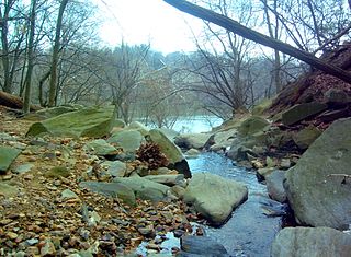
The Little Monocacy River is a 10.1-mile-long (16.3 km) tributary stream of the Potomac River. Despite its name, the stream does not feed into the Monocacy River. The Little Monocacy is located almost entirely in Montgomery County, Maryland, and enters the Potomac just downstream from where the Monocacy enters the Potomac. Its headwaters rise southwest of Comus, and most of its approximately 17-square-mile (44 km2) watershed is farmland and pasture (60.56%) or forested land (36.03%).
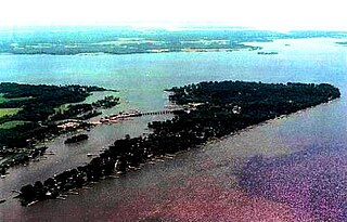
The Wicomico River is a 13.0-mile-long (20.9 km) tributary of the lower tidal portion of the Potomac River located in the U.S. state of Maryland south of Washington, DC. The river empties into the Potomac at Cobb Island and St. Margaret's Island. Its watershed area is 77 square miles (200 km2), with 2% impervious surface in 1994. in Charles, St. Mary's, and southern Prince George's counties. The lower section of the river forms part of the boundary between Charles and St. Mary's counties. The Wicomico River was designated a Scenic River under the Maryland Scenic River Act in 1968, and there are Scenic River Commissions for it in both Charles and St. Mary's counties.

Four Mile Run is a 9.4-mile-long (15.1 km) stream in Northern Virginia that starts near Interstate 66, at Gordon Avenue in Fairfax County and proceeds southeast through Falls Church to Arlington County in the U.S. state of Virginia. Most of the stretch is parkland and is paralleled by two paved non-motorized transport and recreational trails, the Washington & Old Dominion Railroad Trail and the Four Mile Run Trail.

Pimmit Run is a 7.8-mile-long (12.6 km) stream in northern Virginia that runs from Fairfax County to the Potomac River at Chain Bridge in the Arlingwood neighborhood of Arlington.

Hunting Creek is a cove and tributary stream of the Potomac River between the City of Alexandria and Fairfax County in Virginia. It is formed by the confluence of Cameron Run and Hooff Run. The community of Huntington takes its name from the creek. Jones Point forms the north side. Dyke Marsh is just to the south. The George Washington Memorial Parkway crosses it on a bridge.

Accotink Creek is a 25.0-mile-long (40.2 km) tributary stream of the Potomac River in Fairfax County, Virginia, in the United States. At Springfield, Virginia, Accotink Creek is dammed to create Lake Accotink. The stream empties into the Potomac at Gunston Cove's Accotink Bay, to the west of Fort Belvoir.
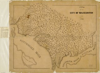
Tiber Creek or Tyber Creek was originally called Goose Creek. It is a tributary of the Potomac River in Washington, D.C.. It was a free-flowing creek until 1815 when it was channeled to become part of the Washington City Canal. Today, it is underground in tunnels around the city including under Constitution Avenue NW.
Spout Run is a small stream in Arlington County, Virginia. From its source along Interstate 66, Spout Run flows on a northeastern course paralleling the Spout Run Parkway through a gorge and empties into the Potomac River opposite the Three Sisters. With the exception of the adjacent parkway, Spout Run is surrounded predominantly by forests.
Cabin John Creek is a tributary stream of the Potomac River in Montgomery County, Maryland. The watershed covers an area of 26 square miles (67 km2). The headwaters of the creek originate in the city of Rockville, and the creek flows southward for 10.9 miles (17.5 km) to the Potomac River.
Chopawamsic Creek is a 6.8-mile-long (10.9 km) tributary of the Potomac River in Prince William and Stafford counties, Virginia. Chopawamsic Creek is formed by the confluence of the North and South Branches of Chopawamsic Creek and empties into the Potomac River south of Quantico at the Marine Corps Base Quantico's Air Station. Breckenridge Reservoir lies at the stream's confluence with the North and South Branches. Along with its North Branch, Chopawamsic Creek forms part of the boundary between Prince William and Stafford counties. The North Branch flows through part of the Chopawamsic Backcountry Area in Prince William Forest Park.

Difficult Run is a 15.9-mile-long (25.6 km) tributary stream of the Potomac River in Northern Virginia in the United States. The area has had many historical uses dating back to the early 1800s. Today, the area is used recreationally by visitors interested in the watershed's variety of options including hiking, biking, fishing, boating, climbing, and bird watching. The wildlife at Difficult Run is vast as 163 different species can be seen depending on the season. There are 41 different soil types found on the trail and alongside the stream. The stream is part of the greater 57.7- square-mile Drainage basin, or watershed, located in the north-central portion of Fairfax County and drains directly to the Potomac River.

Little Hunting Creek is a 3.6-mile-long (5.8 km) primarily tidal tributary of the Potomac River located in Fairfax County, Virginia, not to be confused with Hunting Creek farther north. A stone-arch bridge, completed in 1931, carries traffic on the George Washington Memorial Parkway across the narrow mouth of the creek, located 96.6 miles (155.5 km) upriver from the mouth of the Potomac. The Washington family built its Mount Vernon plantation on the Potomac River along both banks of Little Hunting Creek during colonial times. The creek is bordered by residential communities in addition to the Mount Vernon property. It is a popular location for recreational fishing, and much of the wildlife characteristic of the tidal Potomac wetlands can be spotted there.

Little Falls Branch, a 3.8-mile-long (6.1 km) tributary stream of the Potomac River, is located in Montgomery County, Maryland. In the 19th century, the stream was also called Powder Mill Branch. It drains portions of Bethesda, Somerset, Friendship Heights, and the District of Columbia, flows under the Chesapeake and Ohio Canal (C&O), and empties into the Potomac at Little Falls rapids, which marks the upper end of the tidal Potomac.

Paint Branch is a 14.0-mile-long (22.5 km) stream that flows through Montgomery County and Prince George's County, Maryland. It is a tributary of the Northeast Branch, which flows to the Anacostia River, Potomac River and the Chesapeake Bay.
Rock Run is a tributary stream of the Potomac River in Montgomery County, Maryland. The headwaters of the stream rise in the village of Potomac, and the creek flows southeast for 5.3 miles (8.5 km) to the Potomac River.

Gulf Branch is a stream in Arlington County, Virginia. From its source southwest of the Gulf Branch Nature Center, Gulf Branch flows on a northeastern course and empties into the Potomac River within the Federal parklands of the George Washington Memorial Parkway. Gulf Branch is surrounded predominantly by forests.
Windy Run is a small stream in Arlington County, Virginia. From its source near Lorcom Lane, Windy Run flows on a northeastern course and empties into the Potomac River within the Federal parklands of the George Washington Memorial Parkway. Windy Run is surrounded predominantly by forests. It is known by many of the Arlington locals as simply "The Falls".
Muddy Branch is a tributary stream of the Potomac River in Montgomery County, Maryland, United States, located about 14 miles (23 km) northwest of Washington, D.C.
Foundry Branch is a tributary stream of the Potomac River in Washington, DC. The historic headwaters of the stream originate in the Tenleytown area in Northwest Washington, however at present the section of the stream north of Massachusetts Avenue is hydrologically separated from the lower section and runs through a large stormwater pipe under the daylighted portion. The daylight portion of the stream can be seen south of Massachusetts Avenue, in Glover-Archbold Park, and the stream continues to the Potomac, which drains to the Chesapeake Bay.
Pope Branch is a tributary stream of the Anacostia River in Washington, DC. The headwaters of the stream originate near Fort Davis Drive, and the branch flows roughly northwest for about 1 mile (1.6 km) to the Anacostia, which drains to the Potomac River and the Chesapeake Bay. The watershed area of Pope Branch is about 0.4 square miles (1.0 km2).


