Battery Kemble Park

Last updated
Battery Kemble Park
Battery Kemble Park (3924580696).jpg
Battery Kemble Park, September 2009
Location map District of Columbia street.png
Red pog.svg
Location within Washington, D.C.
Location Washington, D.C.
Coordinates 38°55′49″N77°05′39″W / 38.930203°N 77.094111°W / 38.930203; -77.094111 Coordinates: 38°55′49″N77°05′39″W / 38.930203°N 77.094111°W / 38.930203; -77.094111
Website www.nps.gov/cwdw/historyculture/battery-kemble.htm

Battery Kemble Park is a park in Northwest Washington D.C., administered by the National Park Service. [1]

Contents

Battery Kemble was a Union Army defensive site during the Civil War. The battery was located on Ridge Road (now Nebraska Avenue, NW), and included two 100-pound Parrott rifles, placed in such a way as to sweep Chain Bridge, Aqueduct Bridge, and Virginia beyond. Today, the parapet and gun positions are fairly well preserved and remain visible. The park is located south of Nebraska Avenue along Maddox Branch. Battery Kemble Park is bounded by Chain Bridge Road (to the west), MacArthur Boulevard (to the south), 49th Street (to the east), and Nebraska Avenue, NW (north). It is considered part of the Palisades neighborhood. The park is popular for running, sledding, and nature walks. [2]

Civil War defenses of Washington, or 'Fort Circle'

Battery Kemble was completed during the Autumn of 1861, as part of the Civil War Defenses of Washington, also known as the Fort Circle. It was named after Gouverneur Kemble of Cold Spring, New York, former superintendent of West Point Foundry, where most of the heavy Army and Navy guns were made during the Civil War. [3] Battery Kemble is on the high point of land, 387 feet (118 m) above mean low level of the Potomac River, where its guns could protect both Chain Bridge and Aqueduct Bridge. The artillery had "an extreme range of 3 miles, while it is under the direct fire, to a distance of at least 1,000 yards of the works." [4] The earthwork remains of the battery are distinct and well preserved. [5]

Battery Kemble was one in a chain of fortifications directly protecting the DC side of Chain Bridge. Other nearby fortifications included Battery Cameron (two 100-pounder Parrott rifles), Battery Parrott (two 100-pounder Parrott rifles), Battery Martin Scott (one 8-inch Seacoast howitzer, two 32-pounder cannon; later changed to two 6-pounder cannon and two 12-pounder howitzers), and Battery Vermont (three 32-pounder seacoast cannon). Battery Kemble was built to provide support to Fort Stevens and Fort Slocum and to guard northern approaches to the city. [6]

Wartime garrisons were manned by the 2nd U.S. Artillery, 9th New York Heavy Artillery, and Company A, 1st New Hampshire Heavy Artillery.

Battery Kemble in 1861 Guide leaflets for the tour of historic Civil War defenses, Washington D.C. LOC 2005626571-7.jpg
Battery Kemble in 1861

In 1861, an Army report described the initial conditions there:

Battery Kemble, Capt. F. E. Shaw commanding. – Garrison, one company First Maine Heavy Artillery – 3 officers, 1 ordnance - sergeant, 54 men. Armament, two 100-pounder Parrotts. Magazines, one; dry and in good order. Ammunition, full supply and serviceable. Implements, complete and serviceable. Drill in artillery, fair. Drill in infantry, fair. Garrison is sufficient.

"General Reports About The Defenses", Office Chief Engineer Army of Potomac, Washington, D.C., December 10, 1861. [7]

The soldiers' quarters at Battery Kemble (and Battery Cameron) remained unfinished, and in need of materials for completion, as late as 1864. [8] Contemporaneous accounts by Augusta Weaver, "a woman of means" living nearby, describe how soldiers stationed at Battery Kemble pillaged neighboring residents' pantries, her own included. [9] The property on which Battery Kemble was constructed was relinquished to the U.S. government by William A.T. Maddox, a career U.S. Marine Corps officer. [10] [11]

The land for Battery Kemble Park was reacquired by the federal government sometime between 1916 and 1923, a period of time during which much of the land for the D.C.-area Fort Parks was acquired. The National Capital Parks and Planning Commission acquired approximately 2.8 acres (11,000 m2) for the "Fort Kemble" Park. However, it was almost fifteen years before the government corrected the name to "Battery Kemble." [12] :fn18

Fort Parks and Fort Drive

Battery Kemble had a prominent place in 50s-60s-era plans for Fort Drive, a plan originally conceived in the first decades of the twentieth century to connect D.C.'s Civil war defenses with a ring-shaped parkway ("not just widened streets"). The National Park Service and the District of Columbia signed a memorandum of agreement, on October 24, 1944, for the development of two Fort Drive sections, the first of which was from MacArthur Boulevard to Nebraska Avenue. [13] National Park Service Associate Director A.E. Demaray informed the Secretary of the Interior that 98 percent of the Fort Drive right-of-way had been acquired and that its construction "is believed to be of first importance."

On October 1, 1964, the National Capital Planning Commission staff and other professionals took a bus tour to help decide whether it should "be developed as a park-like road, can it lend itself to be an intermediate loop, or should the forts remain isolated for just recreational use?" By May 1965, the local newspapers extolled a new proposal by Fred Tuemmler as a substitute for the Fort Drive. Tuemmler, whom the National Capital Planning Commission hired to re-evaluate Fort Drive, suggested the right-of-way land should "be reconstituted as a recreational facility" and, to emphasize that park recreation concept, rename it "Fort Park System." It would be "a place to get away from cars." Further, he saw it as a 30-mile (48 km) "ring of recreation and green space" around the city, running from Fort Greble Park to Battery Kemble Park, with hiking and bicycle paths. [12] :fns 21–24

Administration

Battery Kemble's current superintendent is Cindy Cox, who succeeded Adrienne Coleman as Superintendent of Rock Creek Park, as of January 1, 2010.

It is policed by the United States Park Police (District 3), Metropolitan Police Department (2nd District), and occasionally U.S. Secret Service.

Former Superintendents include Joseph Brown (5/24/1965 - 5/6/1967), J. A. Martinek (5/7/1967 - 5/29/1971), and Joseph Antosca (9/5/1971 - 4/27/1972). [14] [15]

Art and music

The earthworks slope at Battery Kemble was depicted in a 1989 landscape painting by David Holt entitled, Hillside in Battery Kemball [sic] Park, Washington, D.C. In 1991, Gunnar Plake created Battery Kemble, a C-type photographic print on aluminum. A view looking southwest, across the driveway, and towards a grove of bamboo, inspired the 2006 Carlton Fletcher painting Battery Kemble (676). Howard Carr, a painter who lives nearby, cites Battery Kemball as the inspiration for most of his works.[ citation needed ]

Natural environment and geology

The park has abundant pine trees, and is home to many species of birds. [16] There is also a dense grove of bamboo. Maddox Branch, a tributary of the Potomac River, flows through the park. [17] The park is home to a chestnut oak, that is rated as the largest known tree of its species in the United States. [18]

Related Research Articles

Rock Creek Park Urban park in Washington, D.C., U.S.

Rock Creek Park is a large urban park that bisects the Northwest quadrant of Washington, D.C. The park was created by an Act of Congress in 1890 and today is administered by the National Park Service. In addition to the park proper, the Rock Creek administrative unit of the National Park Service administers various other federally owned properties in the District of Columbia located to the north and west of the National Mall, including Meridian Hill Park on 16th Street, N.W., the Old Stone House in Georgetown, and certain of the Fort Circle Parks, a series of batteries and forts encircling the District of Columbia for its defense during the U.S. Civil War.

Parrott rifle Muzzle loading artillery weapon

The Parrott rifle was a type of muzzle-loading rifled artillery weapon used extensively in the American Civil War.

Fort Monroe Moated, six-sided, historical bastion fort in Hampton, Virginia

Fort Monroe, managed by partnership between the Fort Monroe Authority for the Commonwealth of Virginia, the National Park Service as the Fort Monroe National Monument, and the City of Hampton, is a former military installation in Hampton, Virginia, at Old Point Comfort, the southern tip of the Virginia Peninsula, United States. Along with Fort Wool, Fort Monroe originally guarded the navigation channel between the Chesapeake Bay and Hampton Roads—the natural roadstead at the confluence of the Elizabeth, the Nansemond and the James rivers. Union General George B. McClellan landed his forces at The fort during Peninsula campaign of 1862 during the American Civil War. Until disarmament in 1946, the areas protected by the fort were the entire Chesapeake Bay and Potomac River regions, including the water approaches to the cities of Washington, D.C. and Baltimore, Maryland, along with important shipyards and naval bases in the Hampton Roads area. Surrounded by a moat, the six-sided bastion fort is the largest fort by area ever built in the United States.

Richmond National Battlefield Park 769 acres in Virginia (USA) maintained by the National Park Service

The Richmond National Battlefield Park commemorates 13 American Civil War sites around Richmond, Virginia, which served as the capital of the Confederate States of America for most of the war. The park connects certain features within the city with defensive fortifications and battle sites around it.

Fort Ethan Allen (Arlington, Virginia) United States historic place

Fort Ethan Allen was an earthwork fortification that the Union Army built in 1861 on the property of Gilbert Vanderwerken in Alexandria County, Virginia, as part of the Civil War defenses of Washington. The remains of the fort are now within Arlington County's Fort Ethan Allen Park.

Fort Richardson (Arlington, Virginia) Civil war fort in Arlington County, Virginia

Fort Richardson was a detached redoubt that the Union Army constructed in September 1861 as part of the Civil War defenses of Washington. The Army built the fort shortly after its rout at the First Battle of Bull Run (Manassas) in late July 1861. The Army named the fort after General Israel B. Richardson, whose division had been deployed to defend the City of Washington against attack by way of the Columbia Turnpike.

Fort Washington Park Historic fort and military reservation in Fort Washington, Maryland, US

Fort Washington, located near the community of Fort Washington, Maryland, was for many decades the only defensive fort protecting Washington D.C. The original fort, overlooking the Potomac River, was completed in 1809, and was begun as Fort Warburton, but renamed in 1808. During the War of 1812, the fort was destroyed by its own garrison during a British advance.

Fort Ward (Virginia) United States historic place

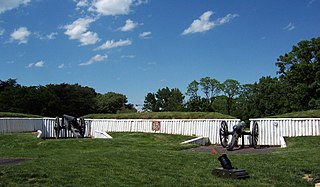
Fort Ward is a former Union Army installation now located in the city of Alexandria in the U.S. state of Virginia. It was the fifth largest fort built to defend Washington, D.C. in the American Civil War. It is currently well-preserved with 90-95% of its earthen walls intact.

Fort Popham

Fort Popham is a Civil War-era coastal defense fortification at the mouth of the Kennebec River in Phippsburg, Maine. It is located in sight of the short-lived Popham Colony and, like the colony, named for George Popham, the colony's leader.

Fort Dupont Park is a 376-acre (1.52 km2) wooded park under the management of the National Park Service located in Washington, DC. The name of the park comes from the old Civil War earthwork fort that lies within the park. The fort was one of several designed to defend Washington from a Confederate attack during the Civil War. There are few remains of the actual fortifications.

Fort Bunker Hill Historical fort in Washington, D.C., United States

Fort Bunker Hill was one of seven temporary earthwork forts part of the Civil War Defenses of Washington, D.C., during the Civil War built in the Northeast quadrant of the city at the beginning of the Civil War by the Union Army to protect the city from the Confederate Army. From west to east, the forts were: Fort Slocum, Fort Totten, Fort Slemmer, Fort Bunker Hill, Fort Saratoga, Fort Thayer and Fort Lincoln. Unlike other forts, today very little remains of the structure.

Fort Stanton (Washington, D.C.) Historical fort in Washington, D.C., US

Fort Stanton was a Civil War-era fortification constructed in the hills above Anacostia in the District of Columbia, USA, and was intended to prevent Confederate artillery from threatening the Washington Navy Yard. It also guarded the approach to the bridge that connected Anacostia with Washington. Built in 1861, the fort was expanded throughout the war and was joined by two subsidiary forts: Fort Ricketts and Fort Snyder. Following the surrender of the Army of Northern Virginia, it was dismantled and the land returned to its original owner. It never saw combat. Abandoned after the war, the site of the fort was planned to be part of a grand "Fort Circle" park system encircling the city of Washington. Though this system of interconnected parks never was fully implemented, the site of the fort is today a park maintained by the National Park Service, and a historical marker stands near the fort's original location.

Fort Bayard (Washington, D.C.) Historic fort in Washington, D.C.

Fort Bayard was an earthwork fort constructed in 1861 northwest of Tenleytown in the District of Columbia as part of the defenses of Washington, D.C., during the American Civil War. It never faced major opposition during the conflict and was decommissioned following the surrender of Robert E. Lee's Army of Northern Virginia. Named after Brigadier General George Dashiell Bayard, who was killed at the Battle of Fredericksburg, the site of the fort is in Boundary Park, located at the intersection of River Road and Western Avenue NW in Washington, D.C., and is maintained by the U.S. National Park Service. No trace of the fort remains, though a marker commemorating its existence has been erected by the Park Service.

Fort Lyon (Virginia) Historic fort in Virginia, USA

Fort Lyon was a timber and earthwork fortification constructed south of Alexandria, Virginia as part of the defenses of Washington, D.C. during the American Civil War. Built in the weeks following the Union defeat at Bull Run, Fort Lyon was situated on Ballenger's Hill south of Hunting Creek, and Cameron Run, near Mount Eagle. From its position on one of the highest points south of Alexandria, the fort overlooked Telegraph Road, the Columbia Turnpike, the Orange and Alexandria Railroad, the Little River Turnpike, and the southern approaches to the city of Alexandria, the largest settlement in Union-occupied Northern Virginia.

Civil War Defenses of Washington United States historic place

The Civil War Defenses of Washington were a group of Union Army fortifications that protected the federal capital city, Washington, D.C., from invasion by the Confederate States Army during the American Civil War. The sites of some of these fortifications are within a collection of National Park Service (NPS) properties that the National Register of Historic Places identifies as the Fort Circle. The sites of other such fortifications in the area have become parts of state, county or city parks or are located on privately owned properties. A trail connecting the sites is part of the Potomac Heritage Trail.

Fort Willard

Fort Willard is a former Union Army installation now located in the Belle Haven area of Fairfax County in the U.S. state of Virginia. It is currently undergoing preservation treatment to protect its earthen walls and trenches.

Fort Craig (Virginia) Civil War-era fort in Arlington County, Virginia

Fort Craig was a small lunette that the Union Army constructed in September 1861 in Arlington County in Virginia during the American Civil War. The lunette was part of the Civil War defenses of Washington.

Fort Tillinghast

Fort Tillinghast was a small lunette that the Union Army constructed in Alexandria County, Virginia, as part of the Civil War defenses of Washington. Fort Tillinghast stood about 0.6 miles away from Arlington House, the Union-occupied estate of Confederate General Robert E. Lee.

Fort Totten Park Washington, D.C. Civil War memorial site

Fort Totten Park is an American Civil War memorial on the site of a Union fort in Washington, DC. It is under the management of the National Park Service.

Fort Slocum was one of seven temporary earthwork forts, part of the Civil War Defenses of Washington, D.C., during the Civil War, built in the Northeast quadrant of the city after the beginning of the war by the Union Army to protect the city from the Confederate Army. From west to east, the forts were as follow: Fort Slocum, Fort Totten, Fort Slemmer, Fort Bunker Hill, Fort Saratoga, Fort Thayer and Fort Lincoln.

References

  1. U.S. National Park Service (NPS). Washington, DC. "Battery Kemble." Civil War Defenses of Washington. Accessed 2012-10-28.
  2. Williams, Brett, et al. "Rapid Ethnographic Assessment of Civil War Defenses of Washington and Anacostia Park Management Plans." NPS Denver Service Center, 1998.
  3. The name was recommended by Brig. Gen. and Chief Engineer Defenses of Washington J.G. Barnard in a letter on January 7, 1863, to Maj. Gen. S.P. Heintzelman, Commander of the Defenses of Washington.
  4. NPS (2004). "Civil War Defenses of Washington. App. C: Naming the Forts." Archived 2007-11-25 at the Wayback Machine Historic Resource Study.
  5. NPS. Park Historic Structures Program. "Battery Kemble; Earthworks." Archived 2016-01-28 at the Wayback Machine List of Classified Structures. Structure No. 521-01. LCS ID 005362. Park: Rock Creek Park. Accessed 2012-10-28.
  6. Cooling III, Benjamin Franklin; Owen II, Walton H. (6 October 2009). Mr. Lincoln's Forts: A Guide to the Civil War Defenses of Washington. Scarecrow Press. pp. 139–141. ISBN   978-0-8108-6307-1.
  7. NPS (2004). "Civil War Defenses of Washington: App. E: General Reports About the Defenses." Historic Resource Study.
  8. NPS (2004). "Civil War Defenses of Washington: Maintenance of the Defenses." Historic Resource Study.
  9. "Sunset on the Palisades; Watching the quiet passing of a fragile Washington neighborhood", Terrence Downs, The Washington Post Magazine; Pg. 17, Sunday, February 5, 1978.
  10. NPS (2004). Civil War Defenses of Washington: The Land and the Owners." Historic Resource Study.
  11. National Archives: Record Group 328, Records of the National Capital Planning Commission; General Records, Parks & Recreation, Planning Files, 1924-67; 535, Parks & Recreation, Battery Kemble Park.
  12. 1 2 NPS (2004). "Civil War Defenses of Washington: The Fort Park System." Historic Resource Study.
  13. Barthelmes, Wes. In Battery Kemble Park: Citizen Groups Hit Fort Drive Project." The Washington Post, April 27, 1955
  14. Originally, in 1965, Battery Kemball fell under an administrative region of the National Park Service designated as "National Capital-North", which included Rock Creek Park, Peirce Mill, the Old Stone House, and Fort Circle Parks from Fort Totten to Battery Kemble, Battleground National Cemetery, D.C., and others. During the period from June 1972 through March 1975, these areas were administered by the region designated "National Capital Parks - West and East and George Washington Memorial Parkway". The administrative name of this area was changed to Rock Creek Park on March 16, 1975. Currently, the administrative region designated as Rock Creek Park also now includes: Fort Bunker Hill, Fort Totten, Fort Slocum, Fort Stevens, Battleground National Cemetery, Fort DeRussy, Fort Reno, and Fort Bayard.
  15. "National Park Service: Historic Listings of NPS Officials". Archived from the original on 2007-08-21.
  16. "Battery Kemble | DC Audubon Society". Archived from the original on August 17, 2009. Retrieved March 20, 2010.
  17. United States Geological Survey. Reston, VA. "Maddox Branch." Geographic Names Information System (GNIS). Accessed 2012-10-28.
  18. "Chestnut Oak (Quercus montana) - American Forests". Archived from the original on 2016-10-09. Retrieved 2016-10-06.