Pennsylvania Avenue is a primarily diagonal street in Washington, D.C. that connects the United States Capitol with the White House and then crosses northwest Washington, D.C. to Georgetown. Traveling through southeast Washington from the Capitol, it enters Prince George's County, Maryland, and becomes MD Route 4 and then MD Route 717 in Upper Marlboro, and finally Stephanie Roper Highway.

Dupont Circle is a historic roundabout park and neighborhood of Washington, D.C., located in Northwest D.C. The Dupont Circle neighborhood is bounded approximately by 16th Street NW to the east, 22nd Street NW to the west, M Street NW to the south, and Florida Avenue NW to the north. Much of the neighborhood is listed on the National Register of Historic Places. However, the local government Advisory Neighborhood Commission and the Dupont Circle Historic District have slightly different boundaries.

Farragut North station is an underground Washington Metro station in Washington, D.C., located on the Red Line. The station serves Downtown Washington and is immediately northwest of Farragut Square. With an average of 7,615 daily riders in 2023, Farragut North was the sixth-busiest stop in the system.
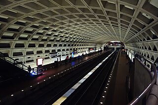
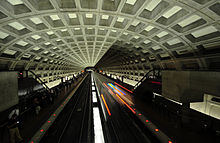
Farragut West station is a Washington Metro station in Downtown Washington, D.C., United States. The side-platformed station was opened on July 1, 1977, and is operated by the Washington Metropolitan Area Transit Authority (WMATA). Providing service for the Blue, Orange and Silver Lines, the station is located just west of Farragut Square with two entrances on I Street at 17th and 18th Streets NW.

McPherson Square station is a Washington Metro station in Downtown, Washington, D.C., United States. The side-platformed station is operated by the Washington Metropolitan Area Transit Authority (WMATA). Providing service for the Blue, Orange, and Silver Lines, the station is located between McPherson Square and Franklin Square, with two entrances on I Street at Vermont Avenue and 14th Street NW. This is the main station to access the White House, and the Vermont Avenue exit is directly underneath the Department of Veterans Affairs building.

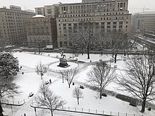
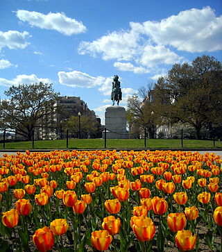
Farragut Square is a city square in Washington, D.C.'s Ward 2. It is bordered by K Street NW to the north, I Street NW to the south, on the east and west by segments of 17th Street NW, and interrupts Connecticut Avenue NW. It is the sister park of McPherson Square two blocks east. It is serviced by two stops on the Washington Metro rail system: Farragut North on the Red Line and Farragut West on the Blue, Orange, and Silver Lines.

Logan Circle is a historic roundabout park and neighborhood of Washington, D.C., located in Northwest D.C. The majority of Logan Circle is primarily residential, except for the highly-commercialized 14th Street corridor that passes through the western part of the neighborhood. In the 21st century, Logan Circle has been the focus of urban redevelopment and become one of Washington's most expensive neighborhoods. Today, Logan Circle is also one of D.C.'s most prominent gay neighborhoods.

President's Park, located in Downtown Washington, D.C., encompasses the White House and includes the Eisenhower Executive Office Building, the Treasury Building, and grounds; the White House Visitor Center; Lafayette Square; and The Ellipse. President's Park was the original name of Lafayette Square.

14th Street NW/SW is a street in Northwest and Southwest quadrants of Washington, D.C., located 1.25 miles (2.01 km) west of the U.S. Capitol. It runs from the 14th Street Bridge north to Eastern Avenue.

There are many outdoor sculptures in Washington, D.C. In addition to the capital's most famous monuments and memorials, many figures recognized as national heroes have been posthumously awarded with his or her own statue in a park or public square. Some figures appear on several statues: Abraham Lincoln, for example, has at least three likenesses, including those at the Lincoln Memorial, in Lincoln Park, and the old Superior Court of the District of Columbia. A number of international figures, such as Mohandas Gandhi, have also been immortalized with statues. The Statue of Freedom is a 19½-foot tall allegorical statue that rests atop the United States Capitol dome.

The U Street Corridor or Greater U Street, sometimes known as Cardozo/Shaw, is a neighborhood in Washington, D.C., located in Northwest D.C. Centered along U Street, the neighborhood is one of Washington's most popular nightlife and entertainment districts, as well as one of the most significant African American heritage districts in the country.
Washington Circle is a traffic circle in the northwest quadrant of Washington, D.C., United States. It is located on the border of the Foggy Bottom and West End neighborhoods, which is a part of the Ward 2 section in Washington. It is the intersection of 23rd Street, K Street, New Hampshire Avenue, and Pennsylvania Avenue, N.W. It borders many buildings of the George Washington University campus. The through lanes of K Street travel underneath the circle via a tunnel, while the service lanes intersect the circle.

Connecticut Avenue is a major thoroughfare in the Northwest quadrant of Washington, D.C., and suburban Montgomery County, Maryland. It is one of the diagonal avenues radiating from the White House, and the segment south of Florida Avenue was one of the original streets in Pierre (Peter) Charles L'Enfant's plan for Washington. A five-mile segment north of Rock Creek was built in the 1890s by a real-estate developer.

NoMa is a neighborhood of Washington, D.C., located in Ward 6 of the city. The neighborhood encompasses the region north of Massachusetts Avenue located north and east of Union Station. It includes the Sursum Corda, Eckington, and Near Northeast areas, as well as a section known as Swampoodle.

Downtown is the central business district of Washington, D.C., located in Northwest D.C. It is the third largest central business district in the United States. The "Traditional Downtown" has been defined as an area roughly between Union Station in the east and 16th Street NW in the west, and between the National Mall on the south and Massachusetts Avenue on the north, including Penn Quarter. However, nowadays, Downtown D.C. can often refer to a larger area, as the DC Office of Planning states:
…most residents, workers, and visitors think of Downtown in a broader sense — including areas as far north as Dupont Circle, as far west as Foggy Bottom, and as far east as Capitol Hill. Only about half of the central city workforce is located within the city’s traditional Downtown.

Franklin Square, or Franklin Park, is a square in downtown Washington, D.C. Purportedly named after Benjamin Franklin, it is bounded by K Street NW to the north, 13th Street NW on the east, I Street NW on the south, and 14th Street NW on the west. It is served by the McPherson Square station of the Washington Metro, which is located just southwest of the park.

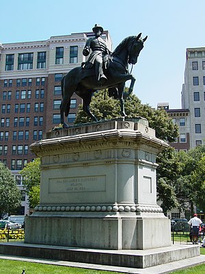
Admiral David G. Farragut is a statue in Washington, D.C., honoring David Farragut, a career military officer who served as the first admiral in the United States Navy. The monument is sited in the center of Farragut Square, a city square in downtown Washington, D.C. The statue was sculpted by female artist Vinnie Ream, whose best-known works include a statue of Abraham Lincoln and several statues in the National Statuary Hall Collection. The monument was dedicated in 1881 in an extravagant ceremony attended by President James A. Garfield, members of his cabinet, and thousands of spectators. It was the first monument erected in Washington, D.C., in honor of a naval war hero.
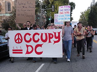
Occupy D.C. was an occupation of public space in Washington, D.C. based at McPherson Square and connected to the Occupy movements that sprung up across the United States in Fall 2011. The group had been demonstrating in McPherson Square since October 1, 2011, and in Freedom Plaza since October 6. Despite crackdowns on other Occupy projects across the country, federal authorities claimed on November 15 that they have no plans to clear McPherson Square Park. The National Park Service decided against eviction after meeting with activists and discussing health and safety conditions.

The Financial Historic District, previously known as the Fifteenth Street Financial Historic District, is a historic district in Washington, D.C. The boundaries of the historic district include 38 buildings, 2 of which are non-contributing properties. Before 2016, the historic district included 20 buildings. The construction of the Treasury Building just east of the White House played a significant role in the financial district's development. Major banks and other financial institutions wanted to be close to the Treasury Building; therefore, many of the historic district's buildings were constructed along 15th Street NW, from Pennsylvania Avenue to I Street.

The Freedman's Bank Building, previously known as the Treasury Annex, is a historic office building located on the corner of Madison Place and Pennsylvania Avenue NW in Washington, D.C. It sits on the east side of Lafayette Square, a public park on the north side of the White House, and across from the Treasury Building. The adjoining properties include the Howard T. Markey National Courts Building to the north and the former Riggs National Bank to the east.