
Martin Luther King Jr. Avenue (also known as MLK Ave) is a major street in the District of Columbia traversing through both the Southwest and Southeast quadrants.
Martin Luther King Jr. Avenue (also known as MLK Ave) is a major street in the District of Columbia traversing through both the Southwest and Southeast quadrants.
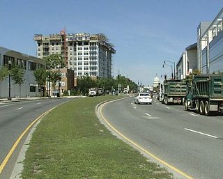
Martin Luther King Jr. Avenue SW begins at the southwestern tip of the District of Columbia near the Blue Plains Advanced Wastewater Treatment Plant. Headed north, the avenue overlaps with South Capitol Street from 2nd St SW to Halley Place SE, where it turns northeast, becoming Martin Luther King Jr. Avenue SE. As it crosses through the Congress Heights neighborhood, MLK Ave changes from a primarily residential neighborhood to a commercial district.
Also in the Congress Heights area, MLK Ave crosses both Alabama Avenue SE and Malcolm X Ave S (Portland Street). After leaving Congress Heights, the street turns north, crossing throughout the campus of St. Elizabeths Hospital, the future home of the Department of Homeland Security. MLK Ave stays headed north, crossing the Suitland Parkway before reaching the Anacostia Metro Station. After passing the Anacostia Station, MLK Ave enters historic Anacostia, crossing Good Hope Road before terminating at the 11th Street Bridges.

Martin Luther King Jr. Avenue was originally constructed in 1855 as Asylum Avenue, [1] when the Government Hospital for the Insane (later known as St. Elizabeths Hospital) was built on the "St. Elizabeth's tract" in the District of Columbia. [2] It was renamed Nichols Avenue in 1879, in honor of St. Elizabeths Hospital Superintendent Charles Henry Nichols. [1] It was renamed again for slain civil rights leader Martin Luther King Jr. on January 15, 1971. [3]
In 2003, the District of Columbia Department of Transportation (DDOT) announced that, as part of its DC Streetcar system, it would build a 2.7 miles (4.3 km) "Anacostia Line" as a demonstration of streetcar technology in the city. [4] The line was planned to begin at Bolling Air Force Base, travel up north along South Capitol Street to the Anacostia Metro station, along Martin Luther King Jr. Avenue SE to Good Hope Road SE, and then along the CSX railroad tracks to the Minnesota Avenue Metro station. [4] However, in October 2010 the city scaled back the Anacostia Line, truncating the northern end of the line so that it would only end at the Anacostia Metro station. [5]
On March 4, 2011, DDOT announced public meetings designed to provide a link between the Anacostia Metro Station and the 11th Street Bridges (under construction as of early 2011) which would meet community concerns about traffic impacts the streetcar would have on MLK Ave, threats to historic preservation in the Anacostia Historic District, and terminating the line at the Anacostia Gateway building at the intersection of MLK Ave and Good Hope Road SE. [6] The 11th Street Bridges are designed to carry streetcars over the Anacostia River, permitting the Anacostia Line to link with the rest of the streetcar system. [7]
The Anacostia Metrorail Station lies on Howard Road Southeast, just off of MLK Avenue.
Metrobus lines A2, A4, A5, A6, A7, A8, A9, A33, B2, P6, V2, W2, W3, W6, W8, 90, and 92 serve MLK Ave [8]
For more information, see List of Metrobus routes

The Green Line is a rapid transit line of the Washington Metro system, consisting of 21 stations in the District of Columbia and Prince George's County, Maryland, United States. The Green Line runs from Branch Avenue to Greenbelt. It was the last line in the original Metrorail plan to be constructed, and is one of three north–south lines through the city of Washington. The Green Line shares tracks with the Yellow line from L'Enfant Plaza to Greenbelt.

Anacostia is a historic neighborhood in Southeast Washington, D.C. Its downtown is located at the intersection of Good Hope Road and Martin Luther King Jr. Avenue. It is located east of the Anacostia River, after which the neighborhood is named.

Anacostia is a Washington Metro station in Washington, D.C. on the Green Line. The station is located in the Anacostia neighborhood of Southeast Washington, with entrances at Shannon Place and Howard Road near Martin Luther King, Jr. Avenue SE. The station serves as a hub for Metrobus routes in Southeast, Washington, D.C. and Prince George's County, Maryland.

Congress Heights is a residential neighborhood in Southeast Washington, D.C., in the United States. The irregularly shaped neighborhood is bounded by the St. Elizabeths Hospital campus, Lebaum Street SE, 4th Street SE, and Newcomb Street SE on the northeast; Shepard Parkway and South Capitol Street on the west; Atlantic Street SE and 1st Street SE on the south; Oxon Run Parkway on the southeast; and Wheeler Street SE and Alabama Avenue SE on the east. Commercial development is heavy along Martin Luther King, Jr. Avenue and Malcolm X Avenue.

14th Street NW/SW is a street in Northwest and Southwest quadrants of Washington, D.C., located 1.25 miles (2.01 km) west of the U.S. Capitol. It runs from the 14th Street Bridge north to Eastern Avenue.
South Capitol Street is a major street dividing the southeast and southwest quadrants of Washington, D.C., in the United States. It runs south from the United States Capitol to the D.C.–Maryland line, intersecting with Southern Avenue. After it enters Maryland, the street becomes Indian Head Highway at the Eastover Shopping Center, a terminal or transfer point of many bus routes.
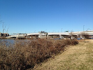
The 11th Street Bridges are a complex of three bridges across the Anacostia River in Washington, D.C., United States. The bridges convey Interstate 695 across the Anacostia to its southern terminus at Interstate 295 and DC 295. The bridges also connect the neighborhood of Anacostia with the rest of the city of Washington.

The DC Circulator is a bus system in Washington, D.C. The District of Columbia Department of Transportation operates the service in a public–private partnership with RATP Dev.

Barney Circle is a small residential neighborhood located between the west bank of the Anacostia River and the eastern edge of Capitol Hill in southeast Washington, D.C., in the United States. The neighborhood is characterized by its sense of community, activism, walkability, and historic feel. The neighborhood's name derives from the eponymous former traffic circle Pennsylvania Avenue SE just before it crosses the John Philip Sousa Bridge over the Anacostia. The traffic circle is named for Commodore Joshua Barney, Commander of the Chesapeake Bay Flotilla in the War of 1812.

Fairlawn is a working class and middle class residential neighborhood in southeast Washington, D.C., United States. It is bounded by Interstate 295, Pennsylvania Avenue SE, Minnesota Avenue SE, Naylor Road SE, and Good Hope Road SE.

The Pennsylvania Avenue Line, designated Routes 32, 34, and 36, is a daily Metrobus route in Washington, D.C., Operating between the Southern Avenue station or Naylor Road station of the Green Line of the Washington Metro and the Archives station of the Green and Yellow Lines of the Washington Metro or Potomac Park. Until the 1960s, it was a streetcar line, opened in 1862 by the Washington and Georgetown Railroad as the first line in the city.
The Anacostia and Potomac River Railroad Company was the fourth streetcar company to operate in Washington, D.C., and the first to cross the Anacostia River. It was chartered in 1870, authorized by Congress in 1875 and built later that year. The line ran from the Arsenal to Union Town. It expanded, adding lines to Congressional Cemetery, Central Market and to the Government Hospital for the Insane; and in the late 1890s it purchased two other companies and expanded their lines. It was reluctant to change its operations, but in 1900 it relented to pressure and became the last company to switch from horsecars to electric streetcars. It was one of the few companies not to be swept up by the two major streetcar companies at the turn of the 20th century, but it could not hold out forever and on August 31, 1912, it was purchased by the Washington Railway and Electric Company and ceased to operate as a unique entity.

The DC Streetcar is a surface streetcar network in Washington, D.C. As of 2017, it consists of only one line: a 2.2-mile (3.5 km) segment running in mixed traffic along H Street and Benning Road in the city's Northeast quadrant.

The Anacostia Historic District is a historic district in the city of Washington, D.C., comprising approximately 20 squares and about 550 buildings built between 1854 and 1930. The Anacostia Historic District was added to the National Register of Historic Places in 1978. "The architectural character of the Anacostia area is unique in Washington. Nowhere else in the District of Columbia does there exist such a collection of late-19th and early-20th century small-scale frame and brick working-class housing."

The District Department of Transportation is an agency of the government of the District of Columbia, in the United States, which manages and maintains publicly owned transportation infrastructure in the District of Columbia. DDOT is the lead agency with authority over the planning, design, construction, and maintenance of alleys, bridges, sidewalks, streets, street lights, and traffic signals in the District of Columbia.

The H Street/Benning Road Line is a currently operating line of DC Streetcar. It has eight stations and began operation on February 27, 2016. The 2.4-mile (3.9 km) line runs along H Street NE and Benning Road NE in Washington, D.C. In September 2016 service was increased from six days a week to seven, and with shorter 12-minute headways.

The Anacostia Line is a partially constructed line of the DC Streetcar, never put into service, intended to connect the Anacostia neighborhood with Joint Base Anacostia–Bolling. Construction occurred in 2009 and 2010, but was terminated before the line was complete.
The Capitol Heights–Minnesota Avenue Line, designated Route V2, V4, is a daily bus route operated by the Washington Metropolitan Area Transit Authority between Capitol Heights station of the Blue and Silver Lines of the Washington Metro and Anacostia station (V2) or Navy Yard–Ballpark station (V4) of the Green Line of the Washington Metro. The line runs every 12 minutes daily and 30 minutes at all other times. Trips take roughly 45-50 minutes.

The Anacostia–Eckington Line, designated Route P6, is a daily bus route operated by the Washington Metropolitan Area Transit Authority between Rhode Island Avenue–Brentwood station of the Red Line of the Washington Metro and Anacostia station of the Green Line of the Washington Metro With late night and early morning trips shortened to operate between Anacostia station of the Green Line of the Washington Metro and L'Enfant Plaza station of the Blue, Orange, Silver, Green and Yellow Lines of the Washington Metro. The line operates every 15–20 minutes during the weekday peak hours, 24 minutes during the weekday midday, and 30–35 minutes during the late nights and weekends. Route P6 trips are roughly 65 minutes long.
The U Street–Garfield Line, designated Routes 90 and 92, are daily bus routes operated by the Washington Metropolitan Area Transit Authority between Anacostia station (90) or Congress Heights station (92) of the Green Line of the Washington Metro and Duke Ellington Bridge (90) in Adams Morgan or U Street station (92) of the Green and Yellow Lines of the Washington Metro. The lines operate every 12 - 24 minutes between 7 AM and 9 PM, and 15 - 30 minutes at all other times. Route 90 and 92 trips are roughly 60 to 70 minutes.