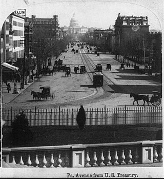
Pennsylvania Avenue is a primarily diagonal street in Washington, D.C., and Prince George's County, Maryland, that connects the United States Capitol with the White House and then crosses northwest Washington, D.C. to Georgetown. Traveling through southeast Washington from the Capitol, it enters Maryland, and becomes MD Route 4 and then MD Route 717 in Upper Marlboro, and finally Stephanie Roper Highway.

Dupont Circle is a historic roundabout park and neighborhood of Washington, D.C., located in Northwest D.C. The Dupont Circle neighborhood is bounded approximately by 16th Street NW to the east, 22nd Street NW to the west, M Street NW to the south, and Florida Avenue NW to the north. Much of the neighborhood is listed on the National Register of Historic Places. However, the local government Advisory Neighborhood Commission and the Dupont Circle Historic District have slightly different boundaries.

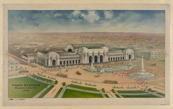
Washington Union Station, known locally as Union Station, is a major train station, transportation hub, and leisure destination in Washington, D.C. Designed by Daniel Burnham and opened in 1907, it is Amtrak's headquarters, the railroad's second-busiest station, and North America's 10th-busiest railroad station. The station is the southern terminus of the Northeast Corridor, an electrified rail line extending north through major cities including Baltimore, Philadelphia, New York City, and Boston, and the busiest passenger rail line in the nation. In 2015, it served just under five million passengers.

K Street is a major thoroughfare in the United States capital of Washington, D.C., known as a center for lobbying and the location of numerous advocacy groups, law firms, trade associations, and some think tanks. In political discourse, "K Street" has become a metonym for Washington's lobbying industry or lobbying in the United States in general, the same way Wall Street in New York City became a metonym for the financial markets of the United States, since many lobbying firms are or at least traditionally were located on the section in Northwest Washington which passes from Georgetown through a portion of Downtown Washington, D.C.
Eckington is a neighborhood in Northeast Washington, D.C., located south of the Prospect Hill and Glenwood Cemeteries. Eckington is less than one mile (1.6 km) southeast of Howard University and exactly one mile north of the United States Capitol. Eckington is also the home of the District of Columbia office of Sirius XM Radio.

14th Street NW/SW is a street in Northwest and Southwest quadrants of Washington, D.C., located 1.25 miles (2.01 km) west of the U.S. Capitol. It runs from the 14th Street Bridge north to Eastern Avenue.

Constitution Avenue is a major east–west street in the northwest and northeast quadrants of the city of Washington, D.C., in the United States. It was originally known as B Street, and its western section was greatly lengthened and widened between 1925 and 1933. It received its current name on February 26, 1931, though it was almost named Jefferson Avenue in honor of Thomas Jefferson.

There are many outdoor sculptures in Washington, D.C. In addition to the capital's most famous monuments and memorials, many figures recognized as national heroes have been posthumously awarded with his or her own statue in a park or public square. Some figures appear on several statues: Abraham Lincoln, for example, has at least three likenesses, including those at the Lincoln Memorial, in Lincoln Park, and the old Superior Court of the District of Columbia. A number of international figures, such as Mohandas Gandhi, have also been immortalized with statues. The Statue of Freedom is a 19½-foot tall allegorical statue that rests atop the United States Capitol dome.

Massachusetts Avenue is a major diagonal transverse road in Washington, D.C., and the Massachusetts Avenue Historic District is a historic district that includes part of it.

Streetcars in Washington, D.C. transported people across the city and region from 1862 until 1962.

Thomas Circle is a traffic circle in Northwest Washington, D.C., in the United States. It is located at the intersection of Massachusetts Avenue NW, Vermont Avenue NW, 14th Street NW, and M Street NW. It is named for George Henry Thomas, a Union Army general in the American Civil War.

Barney Circle is a small residential neighborhood located between the west bank of the Anacostia River and the eastern edge of Capitol Hill in southeast Washington, D.C., in the United States. The neighborhood is characterized by its sense of community, activism, walkability, and historic feel. The neighborhood's name derives from the eponymous former traffic circle Pennsylvania Avenue SE just before it crosses the John Philip Sousa Bridge over the Anacostia. The traffic circle is named for Commodore Joshua Barney, Commander of the Chesapeake Bay Flotilla in the War of 1812.
Washington, D.C. has a number of different modes of transportation available for use. Commuters have a major influence on travel patterns, with only 28% of people employed in Washington, D.C. commuting from within the city, whereas 33.5% commute from the nearby Maryland suburbs, 22.7% from Northern Virginia, and the rest from Washington, D.C.'s outlying suburbs.
The Washington and Georgetown Railroad Company was the first streetcar company to operate in Washington, D.C., United States. It was incorporated and started operations in 1862, using horse-drawn cars on tracks between Georgetown and the Navy Yard. Two additional lines ran on 7th Street NW/SW and 14th Street NW. In 1890, it switched to cable cars. On September 21, 1895, the company was purchased by the Rock Creek Railway and the two formed the Capital Traction Company.
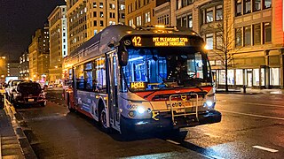
The Mount Pleasant Line, designated Routes 42 and 43, is a daily bus route in Washington, D.C., It was a streetcar line until the 1960s.
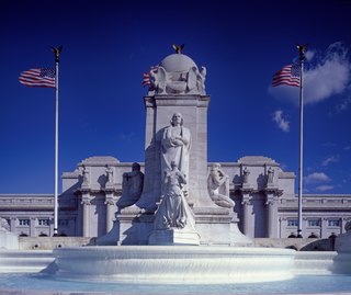
Columbus Fountain also known as the Columbus Memorial is a public artwork by American sculptor Lorado Taft, located at Union Station in Washington, D.C., United States. A centerpiece of Columbus Circle, Columbus Fountain serves as a tribute to the explorer Christopher Columbus. The unveiling in 1912 was celebrated all over Washington, DC over the course of three days with parades, concerts and fireworks gathering tens of thousands of people from all over the world.

General Philip Sheridan is a bronze sculpture that honors Civil War general Philip Sheridan. The monument was sculpted by Gutzon Borglum, best known for his design of Mount Rushmore. Dedicated in 1908, dignitaries in attendance at the unveiling ceremony included President Theodore Roosevelt, members of the President's cabinet, high-ranking military officers and veterans from the Civil War and Spanish–American War. The equestrian statue is located in the center of Sheridan Circle in the Sheridan-Kalorama neighborhood of Washington, D.C. The bronze statue, surrounded by a plaza and park, is one of eighteen Civil War monuments in Washington, D.C., which were collectively listed on the National Register of Historic Places in 1978. The sculpture and surrounding park are owned and maintained by the National Park Service, a federal agency of the Interior Department.

The Stephenson Grand Army of the Republic Memorial, also known as Dr. Benjamin F. Stephenson, is a public artwork in Washington, D.C. honoring Dr. Benjamin F. Stephenson, founder of the Grand Army of the Republic, a fraternal organization for Union veterans. The memorial is sited at Indiana Plaza, located at the intersection of 7th Street, Indiana Avenue, and Pennsylvania Avenue NW in the Penn Quarter neighborhood. The bronze figures were sculpted by J. Massey Rhind, a prominent 20th-century artist. Attendees at the 1909 dedication ceremony included President William Howard Taft, Senator William Warner, and hundreds of Union veterans.

The East Capitol Street-Cardozo Line, designated Route 96, is a daily bus route operated by the Washington Metropolitan Area Transit Authority between Tenleytown-AU station of the Red Line of the Washington Metro and Capitol Heights station of the Blue and Silver Lines of the Washington Metro. The line operates every 20-30 minutes at all times. Route 96 trips are roughly 80 minutes long.