
The White House is the official residence and workplace of the president of the United States. It is located at 1600 Pennsylvania Avenue NW in Washington, D.C. and has been the residence of every U.S. president since John Adams in 1800. The term "White House" is often used as a metonym for the president and his advisers.

Pennsylvania Avenue is a diagonal street in Washington, D.C. and Prince George's County, Maryland that connects the White House and the United States Capitol and then crosses the city to Maryland. In Maryland it is also Maryland Route 4 to MD-717 where it becomes Stephanie Roper Highway. The section between the White House and Congress is called "America's Main Street"; it is the location of official parades and processions, as well as protest marches. Moreover, Pennsylvania Avenue is an important commuter road and is part of the National Highway System.
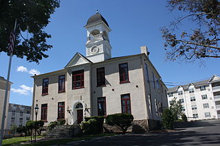
Hatboro is a borough in Montgomery County, Pennsylvania, United States. The population was 7,360 at the 2010 census.

The Oval Office is, since 1909, the working office space of the President of the United States, located in the West Wing of the White House, Washington, D.C.

Washington Union Station is a major train station, transportation hub, and leisure destination in Washington, D.C. Opened in 1907, it is Amtrak's headquarters and the railroad's second-busiest station with annual ridership of just under 5 million and the ninth-busiest in overall passengers served in the United States. The station is the southern terminus of the Northeast Corridor, an electrified rail line extending north through major cities including Baltimore, Philadelphia, New York City, and Boston and the busiest passenger rail line in the nation.

Foggy Bottom is one of the oldest late 18th- and 19th-century neighborhoods in Washington, D.C., located west of the White House and downtown Washington, in the Northwest quadrant. It is bounded roughly by 17th Street NW to the east, Rock Creek Parkway to the west, Constitution Avenue NW to the south, and Pennsylvania Avenue NW to the north.

President's Park, located in Washington, D.C., encompasses the White House including the Eisenhower Executive Office Building, the Treasury Building, and grounds; the White House Visitor Center; Lafayette Square; and The Ellipse. President's Park was the original name of Lafayette Square. The current President's Park is administered by the National Park Service. The park is officially referred to as President's Park or The White House and President's Park.
Constitution Avenue is a major east-west street in the northwest and northeast quadrants of the city of Washington, D.C., in the United States. It was originally known as B Street, and its western section was greatly lengthened and widened between 1925 and 1933. It received its current name on February 26, 1931, though it was almost named Jefferson Avenue in honor of Thomas Jefferson. Constitution Avenue's western half defines the northern border of the National Mall and extends from the United States Capitol to the Theodore Roosevelt Bridge. Its eastern half runs through the neighborhoods of Capitol Hill and Kingman Park before it terminates at Robert F. Kennedy Memorial Stadium. Many federal departmental headquarters, memorials, and museums line Constitution Avenue's western segment.

The Eisenhower Executive Office Building (EEOB)—formerly known as the Old Executive Office Building (OEOB) and even earlier as the State, War, and Navy Building—is a U.S. government building situated just west of the White House in the U.S. capital of Washington, D.C. Maintained by the General Services Administration, it is occupied by the Executive Office of the President, including the Office of the Vice President of the United States.

Independence Avenue is a major east-west street in the southwest and southeast quadrants of the city of Washington, D.C., in the United States, running just south of the United States Capitol. Originally named South B Street, Independence Avenue SW was constructed between 1791 and 1823. Independence Avenue SE was constructed in pieces as residential development occurred east of the United States Capitol and east of the Anacostia River. Independence Avenue SW received its current name after Congress renamed the street in legislation approved on April 13, 1934. Independence Avenue SW originally had its western terminus at 14th Street SW, but was extended west to Ohio Drive SW between 1941 and 1942. The government of the District of Columbia renamed the portion of the road in the southeast quadrant of the city in 1950.

North Philadelphia station is an intercity rail and regional rail station on the Northeast Corridor, located on North Broad Street in the North Philadelphia neighborhood of Philadelphia, Pennsylvania, United States. The Southeastern Pennsylvania Transportation Authority's (SEPTA) Regional Rail Trenton Line and Chestnut Hill West Line account for most of the station's service. Five Amtrak trains - three southbound and two northbound - stop on weekdays only.

Downtown is a neighborhood of Washington, D.C., as well as a colloquial name for the central business district in the northwest quadrant of the city. Geographically, the area extends roughly five to six blocks west, northwest, north, northeast, and east of the White House. Several important museums, theaters, and a major sports venue are located in the area. A portion of this area is known as the Downtown Historic District and was listed on the NRHP in 2001.
Veep is an American political satire comedy television series that aired on HBO from April 22, 2012, to May 12, 2019. The series was created by Armando Iannucci as an adaptation of his sitcom The Thick of It. The protagonist of Veep is Selina Meyer, a fictional vice president. The series follows Meyer and her team as they attempt to make their mark and leave a legacy without becoming mired in the day-to-day political games that define American politics.
The Lafayette Square Historic District is a National Historic Landmark District in Washington, D.C., encompassing a portion of the original L'Enfant Plan for the city's core. It includes the 7-acre (2.8 ha) Lafayette Square portion of President's Park, all of the buildings facing it except the White House, and the buildings flanking the White House to the east and west. The district was designated a National Historic Landmark in 1970.
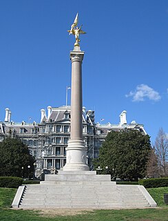
The First Division Monument is located in President's Park, south of State Place Northwest, between 17th Street Northwest and West Executive Avenue Northwest in Washington, DC, United States. The Monument commemorates those who died while serving in the 1st Infantry Division of the U. S. Army.

The Treasury Building in Washington, D.C., is a National Historic Landmark building which is the headquarters of the United States Department of the Treasury. An image of the Treasury Building is featured on the back of the United States ten-dollar bill.

The New Executive Office Building (NEOB) is a U.S. federal government office building in Washington, D.C., for the executive branch.
Executive Office Building may refer to:
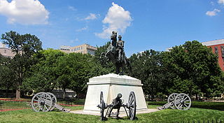
Lafayette Square is a seven-acre public park located within President's Park, Washington, D.C., United States, directly north of the White House on H Street, bounded by Jackson Place on the west, Madison Place on the east and Pennsylvania Avenue on the south. It is named for Gilbert du Motier, Marquis de Lafayette, a French aristocrat and hero of the American Revolutionary War (1775–1783) and includes several statues, including one of Lafayette, and at its center a famous statue of early 19th century U.S. President and general Andrew Jackson on horseback with both front hooves raised. The square and the surrounding structures were designated a National Historic Landmark District in 1970.
East Executive Avenue Northwest is a closed street in Washington, D.C. that, as of 2017, functions as a service road for authorized vehicles making deliveries to the White House, to which it is adjacent. Constructed in the 1870s, it is a short, north-south road that sits between the White House and the United States Treasury Building. The street was closed to public traffic in 1986 due to security concerns.


