
Dupont Circle is a traffic circle, park, neighborhood, and historic district in Northwest Washington, D.C. The Dupont Circle neighborhood is bounded approximately by 16th Street NW to the east, 22nd Street NW to the west, M Street NW to the south, and Florida Avenue NW to the north. Much of the neighborhood is listed on the National Register of Historic Places. However, the local government Advisory Neighborhood Commission and the Dupont Circle Historic District have slightly different boundaries.
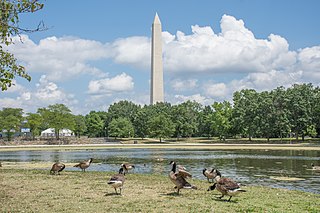
Constitution Gardens is a park area in Washington, D.C., United States, located within the boundaries of the National Mall. The 50-acre (200,000 m2) park is bounded on the west by the Vietnam Veterans Memorial, on the east by 17th St NW, on the north by Constitution Avenue, and on the south by the Reflecting Pool. Constitution Gardens has a small pond, which contains the Memorial to the 56 Signers of the Declaration of Independence on an island open to pedestrians.

Cleveland Park is a residential neighborhood in the Northwest quadrant of Washington, D.C. It is located at 38°56′11″N77°3′58″W and bounded approximately by Rock Creek Park to the east, Wisconsin and Idaho Avenues to the west, Klingle and Woodley Roads to the south, and Rodman and Tilden Streets to the north. Its main commercial corridor lies along Connecticut Avenue NW, where the eponymous Cleveland Park station of the Washington Metro's Red Line can be found; another commercial corridor lies along Wisconsin Avenue. The neighborhood is known for its many late 19th century homes and the historic Art Deco Uptown Theater. It is also home to the William L. Slayton House and the Park and Shop, built in 1930 and one of the earliest strip malls.
The Washington meridians are four meridians that were used as prime meridians in the United States and pass through Washington, D.C. The four which have been specified are:
- through the Capitol
- through the White House
- through the old Naval Observatory
- through the new Naval Observatory.

Maryland Route 396 is a state highway in the U.S. state of Maryland. Known as Massachusetts Avenue, the highway runs 2.23 miles (3.59 km) from MD 614 southeast to Westmoreland Circle near the District of Columbia boundary in Bethesda. MD 396 is an extension of Washington's Massachusetts Avenue into southwestern Montgomery County. The highway was constructed from Westmoreland Circle to Glen Echo in the early to mid-1930s. MD 396 was rolled back to its present western terminus in favor of MD 614 in the late 1970s.

Massachusetts Avenue is a major diagonal transverse road in Washington, D.C., and the Massachusetts Avenue Historic District is a historic district that includes part of it.

Freedom Plaza, originally known as Western Plaza, is an open plaza in Northwest Washington, D.C., United States, located near 14th Street and Pennsylvania Avenue NW, adjacent to Pershing Park. The plaza features an inlay that partially depicts Pierre (Peter) Charles L'Enfant's plan for the City of Washington. The National Park Service administers the Plaza as part of its Pennsylvania Avenue National Historic Site and coordinates the Plaza's activities.

The earliest electric railway, or streetcar line, in Northern Virginia opened in 1892. At their peak, when merged into a single interurban system, the successors of this and several other lines ran between downtown Washington, D.C., Rosslyn and Arlington Junction – in present-day Crystal City – and out to Mount Vernon, Fairfax City and Nauck.

Jefferson Pier, Jefferson Stone, or the Jefferson Pier Stone, in Washington, D.C., marks the second prime meridian of the United States even though it was never officially recognized, either by presidential proclamation or by a resolution or act of Congress.

Downtown is a neighborhood of Washington, D.C., as well as a colloquial name for the central business district in the northwest quadrant of the city. It is the foruth largest central business districts in the United States. Historically, the Downtown has been defined as an area east of 16th Street NW, north of the National Mall and US Capitol complex, and south of Massachusetts Avenue, including the Penn Quarter. However, the city says that most residents, workers, and visitors think of Downtown in a broader sense—including areas as far north as Dupont Circle, the Golden Triangle, as far west as Foggy Bottom, and as far east as Capitol Hill. A small portion of this area is known as the Downtown Historic District and was listed on the NRHP in 2001.

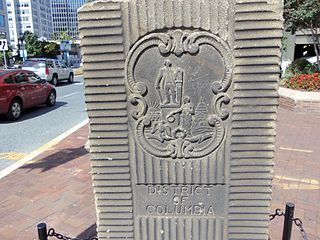
The boundary markers of the original District of Columbia are the 40 milestones that marked the four lines forming the boundaries between the states of Maryland and Virginia and the square of 100 square miles (259 km2) of federal territory that became the District of Columbia in 1801. Working under the supervision of three commissioners that President George Washington had appointed in 1790 in accordance with the federal Residence Act, a surveying team that Major Andrew Ellicott led placed these markers in 1791 and 1792. Among Ellicott's assistants were his brothers Joseph and Benjamin Ellicott, Isaac Roberdeau, George Fenwick, Isaac Briggs and an African American astronomer, Benjamin Banneker.

Little Falls Branch, a 3.8-mile-long (6.1 km) tributary stream of the Potomac River, is located in Montgomery County, Maryland. In the 19th century, the stream was also called Powder Mill Branch. It drains portions of Bethesda, Somerset, Friendship Heights, and the District of Columbia, flows under the Chesapeake and Ohio Canal (C&O), and empties into the Potomac at Little Falls rapids, which marks the upper end of the tidal Potomac.
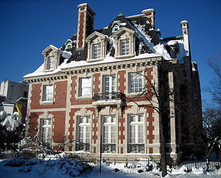
The Thomas T. Gaff House is the diplomatic residence of the Colombian ambassador to the United States, a post currently held by Juan Carlos Pinzon. The house, a contributing property to the Dupont Circle Historic District, is located at 1520 20th Street NW, Washington, D.C., across from the north entrance to the metro station in Dupont Circle and one block from Massachusetts Avenue's Embassy Row.

The Embassy of Uzbekistan in Washington, D.C.,, is the diplomatic mission of the Republic of Uzbekistan to the United States. The current ambassador of Uzbekistan to the United States is Djavlon Vahabov. The embassy is located at 1746 Massachusetts Avenue NW on Embassy Row in Washington, D.C., between Scott Circle and Dupont Circle. Constructed in 1909, the Clarence Moore House is an example of Beaux Arts architecture in blond Roman brick with limestone dressings; it was used by the Canadian government until the 1980s. The house was listed on the National Register of Historic Places (NRHP) on April 3, 1973. The building is also designated a contributing property to the Massachusetts Avenue Historic District and Dupont Circle Historic District, which are both listed on the NRHP.

The Civil War Defenses of Washington were a group of Union Army fortifications that protected the federal capital city, Washington, D.C., from invasion by the Confederate States Army during the American Civil War. The sites of some of these fortifications are within a collection of National Park Service (NPS) properties that the National Register of Historic Places identifies as the Fort Circle. The sites of other such fortifications in the area have become parts of state, county or city parks or are located on privately owned properties. A trail connecting the sites is part of the Potomac Heritage Trail.

The Sulgrave Club is a private women's club located at 1801 Massachusetts Avenue NW on the east side of Dupont Circle in Washington, D.C. The clubhouse is the former Beaux-Arts mansion on Embassy Row built for Herbert and Martha Blow Wadsworth and designed by noted architect George Cary. During World War I the Wadsworth House was used as the local headquarters for the American Red Cross.

Chevy Chase Circle is a traffic circle straddling the border of Chevy Chase, Washington, D.C. and Chevy Chase, Maryland. It sits upon the convergence of Western Avenue, Grafton Street, Magnolia Parkway, Chevy Chase Parkway NW, and Connecticut Avenue.

The L'Enfant Plan for the city of Washington is the urban plan developed in 1791 by Major Pierre (Peter) Charles L'Enfant for George Washington, the first president of the United States.
The Garden Club of America Entrance Markers in Washington, D.C. is a Multiple Property Submission, or MPS, on the National Register of Historic Places. The seven structures that make up the MPS are ceremonial markers at important entrance points to the District of Columbia from the state of Maryland. Sets of two markers are located in Westmoreland Circle, Friendship Heights and Chevy Chase Circle. A single marker is located along Georgia Avenue.

Western Avenue is one of three boundary streets between Washington, D.C., and the state of Maryland. It follows a southwest-to-northeast line, beginning at Westmoreland Circle in the south and ending at Oregon Avenue NW in the north. It is roughly 3.5 miles (5.6 km) in length. First proposed in 1893, it was constructed somewhat fitfully from about 1900 to 1931.

