Logan Circle (Washington, D.C.)

Last updated
Logan Circle
Aerial view of Logan Circle.jpg
14th and P Streets, N.W. (cropped).JPG
Le Diplomate (cropped).jpg
4-9 Logan Circle NW Washington, D.C.jpg
Logan Circle Heritage Trail Preview 16073 (8041253789) (cropped).jpg
Clockwise from the top: aerial view of Logan Circle; Le Diplomate; Luther Place Church; historic homes on Logan Circle; 14th Street.
Map logan circle.jpg
Coordinates: 38°54′35″N77°01′47″W / 38.909644°N 77.029647°W / 38.909644; -77.029647
Country United States
District Washington, D.C.
Quadrant Northwest
Ward2
Government
  Councilmember Brooke Pinto
Area
  Total.22 sq mi (0.6 km2)
 combined area of census tracts 50.03, 50.04, 52.02, and 52.03 [1]
Population
 (2020)
  Total14,403
  Density64,878/sq mi (25,050/km2)
 combined populations of census tracts 50.03, 50.04, 52.02, and 52.03

Logan Circle is a historic roundabout park and neighborhood of Washington, D.C., located in Northwest D.C. [2] [3] The majority of Logan Circle is primarily residential, except for the highly-commercialized 14th Street corridor that passes through the western part of the neighborhood. In the 21st century, Logan Circle has been the focus of urban redevelopment and become one of Washington's most expensive neighborhoods. [4] [5] [6] [7] Today, Logan Circle is also one of D.C.'s most prominent gay neighborhoods. [8] [9]

Contents

Logan Circle includes two historic districts, as well as numerous sites listed on the National Register of Historic Places or as D.C. Historic Landmarks. [3] [10] [11] The circle's origins date to the 1870's, when the area was developed as a residential neighborhood to serve Washington's growing bourgeoisie. In 1901, President William McKinley inaugurated the General Logan equestrian statue at the center of the circle's park. In 1930, the U.S. Congress officially named the circle in honor of Union General John A. Logan.

History

19th century

The General Logan equestrian statue commemorates Civil War general John A. Logan. Designed by Franklin Simmons, it was dedicated in 1901 by President William McKinley. 2019.01.16 DC People and Places, Washington, DC USA 6089 (46722648722).jpg
The General Logan equestrian statue commemorates Civil War general John A. Logan. Designed by Franklin Simmons, it was dedicated in 1901 by President William McKinley.

During the Civil War, present-day Logan Circle was home to Camp Barker, former barracks converted into a refugee camp for newly freed slaves from nearby Virginia and Maryland. [12] In the 1870s, streets, elm trees, and other amenities were installed by Washington Mayor Alexander Robey Shepherd, who encouraged the development of the area. Streetcar tracks were laid into what was then a very swampy area north of downtown Washington, to encourage development of the original Washington City Plan. As a result, the area saw development of successive blocks of Victorian row houses marketed to the upper middle class, which sought to give Washington the reputation, modeled after European capitals, of a city of broad boulevards and well-manicured parks. Many of the larger and more ornate homes came with carriage houses and attached servant's quarters, which were later converted to apartments and rooming houses as the upper middle class moved elsewhere.

20th century

The Iowa, built in 1901, named after Iowa Circle, which was officially renamed by the U.S. Congress in honor of General Logan in 1930. The Iowa Washington, D.C.jpg
The Iowa, built in 1901, named after Iowa Circle, which was officially renamed by the U.S. Congress in honor of General Logan in 1930.

Originally known as Iowa Circle, the park was renamed by Congress in 1930 in honor of John A. Logan, [13] Commander of the Army of the Tennessee during the Civil War, Commander of the Grand Army of the Republic, and U.S. representative and senator for the state of Illinois, who lived at 4 Logan Circle. [14] At the center of the circle stands Major General John A. Logan , an equestrian statue of Logan sculpted by Franklin Simmons and a bronze statue base designed by architect Richard Morris Hunt. On April 9, 1901, the 25-foot monument was dedicated by President William McKinley, Senator Chauncey Depew, and General Grenville M. Dodge. [3] [14] [15]

In the early 20th century, 14th Street NW rose to prominence as a main shopping district for both black and white Washingtonians on the edge of downtown Washington D.C., and became known as an area for auto showrooms. Farther north, "14th and U" became synonymous with a large African-American community, later known as Shaw, which encompassed parts of Logan Circle and U Street to the north. Segregation marked the emergence of this large area of well-preserved Victorian row houses as a predominantly African-American community; the unofficial dividing line was 16th Street NW, several blocks to the west, with Logan Circle and its older homes sandwiched in between.

A row of Victorian townhomes on Vermont Avenue beside the Mary McLeod Bethune House. 1306-1318 Vermont Avenue NW.jpg
A row of Victorian townhomes on Vermont Avenue beside the Mary McLeod Bethune House.

During this period, the original Victorian homes in the area were subdivided into apartments, hostels, and rooming houses. With the end of legal segregation, middle-class residents of both races left the area. Many left after the destructive 1968 Washington, D.C. riots following the assassination of Martin Luther King Jr. These devastated the 14th and U streets commercial corridors.

In 1956, the three inner lanes of 13th Street were paved across Logan Circle to speed the influx of suburban workers into DC. In 1980, to encourage more people to use Metro, the inner lanes across Logan Circle were closed. Later they were removed and the park restored. [16]

During the 1980s and 1990s, Logan Circle, although dominated by Victorian homes that had survived mostly untouched by redevelopment or riots, was considered an unsafe neighborhood by many due to overt drug use and prostitution that existed in the neighborhood. [17] [18] During this period, property values in the area began to increase, but issues of homelessness in the area came to the forefront. Fourteenth Street, NW became widely viewed as Washington's red light district. It also became an area for small, independent theater companies that acquired relatively cheap space north of the circle.

21st century

Retail along 14th Street. Retail and new apartment buildings along 14th St. NW, U Street Corridor, Washington, D.C., February 2019 (cropped).jpg
Retail along 14th Street.

During the 2000s, the area gentrified and housing costs sharply increased after derelict buildings were torn down or remodeled. [2] The commercial corridors along 14th and P streets attracted significant revitalization. They now feature a variety of retailers, restaurants, art galleries, live theater, and nightlife venue gay bars catering to the neighborhood's booming LGBT population. [19] [20] [21] [22] [23]

A watershed event in the development of the neighborhood was the opening of a Whole Foods Market two blocks from Logan Circle in December 2000. No full grocery store was in the area. It was developed on a site previously occupied by an abandoned service garage; it is now one of the chain's highest-grossing markets. [2] [17] [20] Gentrification in Logan Circle has resulted in a dramatic change of neighborhood demographics; since the 1990s, thousands of White young LGBT and hipster adults have moved into the neighborhood, while thousands of Black families have moved out because of rising prices. [24]

Landmarks

Logan Circle Historic District
Houses on Logan Circle and Rhode Island Avenue NW.jpg
Row houses on the northeast corner of Logan Circle, including the former residence (corner building) of writer Ambrose Bierce
LocationJunction of 13th Street, P Street, Rhode Island Avenue, and Vermont Avenue, NW
Coordinates 38°54′35″N77°1′49″W / 38.90972°N 77.03028°W / 38.90972; -77.03028
Area18 acres (7.3 ha)
Architectural style Second Empire, Italianate, Richardsonian Romanesque, Queen Anne
NRHP reference No. 72001426 [25]
Added to NRHPJune 30, 1972

Logan Circle Historic District

The historic Studio Theatre. The Studio Theatre 2.jpg
The historic Studio Theatre.

The Logan Circle Historic District is an eight-block area surrounding the circle, containing 135 late-19th-century residences designed predominantly in the Late Victorian and Richardsonian Romanesque styles of architecture. The district was added to the National Register of Historic Places on June 30, 1972. [3] [11]

The former home of Mary McLeod Bethune, an African American educator, author, and civil rights leader who founded the National Council of Negro Women, is located at 1318 Vermont Avenue NW, one block south of the circle. The Second Empire-style building is a designated National Historic Site and houses the Mary McLeod Bethune Memorial Museum and the National Archives for Black Women's History. [26] [27]

Fourteenth Street Historic District

In addition to the Logan Circle Historic District, the neighborhood includes the much larger Fourteenth Street Historic District, added to the NRHP in 1994. [11] The district's approximately 765 contributing properties are considered historically significant because they represent residential and commercial development resulting from one of the earliest streetcar lines in Washington, D.C., the Capital Traction Company's 14th Street line, built in the 1880s. [10] [11] [28]

John Wesley A.M.E. Zion Church, located on 14th Street NW John Wesley AME Zion Church (1).JPG
John Wesley A.M.E. Zion Church, located on 14th Street NW

The oldest house of worship in the Fourteenth Street Historic District is Luther Place Memorial Church, built 18701873, an ELCA Lutheran church situated on the north side of Thomas Circle. Originally known as Memorial Evangelical Lutheran Church of Washington, D.C., the building was renamed in 1884 after a bronze statue of Martin Luther was installed on the church's property. Luther Place Memorial Church was added to the National Register of Historic Places on July 16, 1973. [10] [29]

The Gladstone and Hawarden, designed by architect George S. Cooper in 1900, are early examples of Washington's middle class apartment houses. Named for U.K. Prime Minister William Gladstone and his estate Hawarden Castle, they are the first documented twin apartment buildings in Washington, D.C. The Gladstone and Hawarden were added to the NRHP on September 7, 1994. [11] [30]

Other landmarks

The District of Columbia Inventory of Historic Sites includes several properties in Logan Circle that are not listed on the National Register of Historic Places. Among them are the former residences of: Charles Manuel "Sweet Daddy" Grace, flamboyant founder of the United House of Prayer For All People; John A. Lankford, the first African American architect in Washington, D.C.; Belford Lawson Jr., lead attorney in the landmark case New Negro Alliance v. Sanitary Grocery Co. ; Alain LeRoy Locke, the first African American Rhodes Scholar and central figure in the Harlem Renaissance; Mary Jane Patterson, the first African American woman to earn a bachelor's degree; Ella Watson, subject of Gordon Parks's famous photograph American Gothic, Washington, D.C.; and James Lesesne Wells, noted graphic artist and longtime art instructor at Howard University. [31] [32] [33] [34] [35] [36] [37] [38] [39] [40] [41] [42]

The Victorian building on the north side of the park, 15 Logan Circle, was built for military officer and diplomat Seth Ledyard Phelps and served as the Korean legation from 1889 to 1905. Following an extensive restoration project, the building now serves as the Old Korean Legation Museum. [43]

The Iowa, designed by Thomas Franklin Schneider in 1901, was the birthplace of anthropologist Julian Steward. [44]

Geography

Intersection of 14th St and R St. Logan Circle 1233 (cropped).jpg
Intersection of 14th St and R St.

The Logan Circle neighborhood is bordered: [45] [46]

The traffic circle is the intersection of 13th Street, P Street, Rhode Island Avenue, and Vermont Avenue. The National Park Service maintains the land located within the traffic circle, a park measuring 360 feet (110 m) in diameter, furnished with wooden benches, decorative lampposts, an iron fence, and concrete sidewalks. [31]

Demographics

Census2020 [47] 2010 [48] 2000 [49] 1990 [50] 1980 [51] 1970 [52] 1960 [53]
Population12,39112,09811,83710,9329,41312,65614,267

The racial composition of the neighborhood is in flux, paralleling its gentrification, with the Black population decreasing from around one quarter to around one tenth of the population (2010 to 2020), while the non-Hispanic White proportion increased by around a fifth, going from around 59% to around 70% of the neighborhood's population during those ten years. The Asian population was up 9%,

Race/EthnicityChange
2020
vs.
2010
2020 [54] 2010 [55]
Non-Hispanic (NH) White+10.7%70.1%59.4%
Hispanic or Latino–2.9%16.0%18.9%
NH Black–14.4%9.8%24.2%
NH Asian (2020)
NH Asian or Pacific Islander (2010)
+0.3%*5.0%4.7%
NH Multiracial+2.0%4.5%2.5%
NH Some other race–0.1$0.4%0.5%
NH American Indian and Alaska Native+0.2%0.25%0.05%
NH Native Hawaiian and Pacific Islandern/a0.2%n/a
Note: population shown is the total of the census tracts covering the area from Massachusetts to S Street and from 11th to 16th streets. in 2020, these were 50.03, 50.04, 52.02, 52.03. In 2010 tracts 50.01, 50.02, and 52.01. from 1960–2000: tracts 50 and 52.01. For 1950 tract 50 and portion of tract 52: blocks 1–19. [56]

Education

The historic Central Union Mission. Central Union Mission, Logan Circle.jpg
The historic Central Union Mission.

Residents are served by the District of Columbia Public Schools (DCPS). Garrison Elementary School in Logan Circle has a capacity of over 350 students. As of 2013 the school had 228 students. [57] Residents are zoned to Garrison, [58] and to Cardozo Education Campus. [59]

Logan Circle is the setting for Dinaw Mengestu's The Beautiful Things That Heaven Bears, a novel about an Ethiopian American struggling to start a new life in Washington, D.C. [60]

Gil Scott-Heron's 1974 song "The Bottle" describes the lives of the alcoholics living in the area. [61]

See also

Related Research Articles

<span class="mw-page-title-main">Dupont Circle</span> Place in the United States

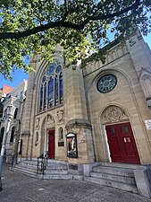
Dupont Circle is a historic roundabout park and neighborhood of Washington, D.C., located in Northwest D.C. The Dupont Circle neighborhood is bounded approximately by 16th Street NW to the east, 22nd Street NW to the west, M Street NW to the south, and Florida Avenue NW to the north. Much of the neighborhood is listed on the National Register of Historic Places. However, the local government Advisory Neighborhood Commission and the Dupont Circle Historic District have slightly different boundaries.

<span class="mw-page-title-main">Mount Pleasant (Washington, D.C.)</span> Neighborhood of Washington, D.C.

Mount Pleasant is a neighborhood in Washington, D.C., located in Northwest D.C. The neighborhood is primarily residential, with restaurants and stores centered along a commercial corridor on Mt. Pleasant Street. Mount Pleasant is known for its unique identity and multicultural landscape, home to diverse groups such as the punk rock, the Peace Corps and Hispanic Washingtonian communities.

<span class="mw-page-title-main">Northwest (Washington, D.C.)</span> Quadrant in the United States

Northwest is the northwestern quadrant of Washington, D.C., the capital of the United States, and is located north of the National Mall and west of North Capitol Street. It is the largest of the four quadrants of the city, and it includes the central business district, the Federal Triangle, and the museums along the northern side of the National Mall, as well as many of the District's historic neighborhoods.

<span class="mw-page-title-main">Shaw (Washington, D.C.)</span> Neighborhood of Washington, D.C.

Shaw is a neighborhood of Washington, D.C., located in the Northwest quadrant. Shaw is a major entertainment and retail hub, and much of the neighborhood is designated as a historic district, including the smaller Blagden Alley-Naylor Court Historic District. Shaw and the U Street Corridor have historically have been the city's hub for African-American social, cultural, and economic life.

<span class="mw-page-title-main">14th Street (Washington, D.C.)</span> Street in northwest and southwest quadrants of Washington, D.C., US

14th Street NW/SW is a street in Northwest and Southwest quadrants of Washington, D.C., located 1.25 miles (2.01 km) west of the U.S. Capitol. It runs from the 14th Street Bridge north to Eastern Avenue.

<span class="mw-page-title-main">U Street (Washington, D.C.)</span> Historic district in Washington D.C.

The U Street Corridor or Greater U Street, sometimes known as Cardozo/Shaw, is a neighborhood in Washington, D.C., located in Northwest D.C. Centered along U Street, the neighborhood is one of Washington's most popular nightlife and entertainment districts, as well as one of the most significant African American heritage districts in the country.

<span class="mw-page-title-main">Bloomingdale (Washington, D.C.)</span> Place in the United States

Bloomingdale is a neighborhood in the Northwest quadrant of Washington, D.C., less than two miles (3 km) north of the United States Capitol building. It is a primarily residential neighborhood, with a small commercial center near the intersection of Rhode Island Avenue and First Street NW featuring bars, restaurants, and food markets.

<span class="mw-page-title-main">Washington Circle</span> Traffic circle in Washington, D.C.

Washington Circle is a traffic circle in the northwest quadrant of Washington, D.C., United States. It is located on the border of the Foggy Bottom and West End neighborhoods, which is a part of the Ward 2 section in Washington. It is the intersection of 23rd Street, K Street, New Hampshire Avenue, and Pennsylvania Avenue, N.W. It borders many buildings of the George Washington University campus. The through lanes of K Street travel underneath the circle in a tunnel, while the service lanes intersect the circle.

<span class="mw-page-title-main">Massachusetts Avenue (Washington, D.C.)</span> Major road in Washington, D.C., U.S.

Massachusetts Avenue is a major diagonal transverse road in Washington, D.C., and the Massachusetts Avenue Historic District is a historic district that includes part of it.

<span class="mw-page-title-main">Thomas Circle</span> Traffic circle

Thomas Circle is a traffic circle in Northwest Washington, D.C., United States. It is located at the intersection of 14th Street, M Street, Massachusetts Avenue, and Vermont Avenue NW. A portion of Massachusetts Avenue travels through a tunnel underneath the circle. The interior of the circle includes the equestrian statue of George Henry Thomas, a Union Army general in the Civil War.

<span class="mw-page-title-main">Sheridan Circle</span> Traffic circle in Washington D.C.

Sheridan Circle is a traffic circle and park in the Sheridan-Kalorama neighborhood of Washington, D.C. The traffic circle, one of two in the neighborhood, is the intersection of 23rd Street NW, Massachusetts Avenue NW, and R Street NW. The buildings along this stretch of Massachusetts Avenue NW are part of Embassy Row, which runs from Scott Circle to Observatory Circle. Sheridan Circle is a contributing property to the Massachusetts Avenue Historic District and the Sheridan-Kalorama Historic District, both listed on the National Register of Historic Places (NRHP). In addition, the equestrian statue of General Philip Sheridan is 1 of 18 Civil War Monuments in Washington, D.C., that were collectively listed on the NRHP.

<span class="mw-page-title-main">Downtown (Washington, D.C.)</span> United States historic place

Downtown is the central business district of Washington, D.C., located in Northwest D.C. It is the third largest central business district in the United States. The "Traditional Downtown" has been defined as an area roughly between Union Station in the east and 16th Street NW in the west, and between the National Mall on the south and Massachusetts Avenue on the north, including Penn Quarter. However, nowadays, Downtown D.C. usually refers to a larger area, as the DC Office of Planning states:

…most residents, workers, and visitors think of Downtown in a broader sense — including areas as far north as Dupont Circle, as far west as Foggy Bottom, and as far east as Capitol Hill. Only about half of the central city workforce is located within the city’s traditional Downtown.

<span class="mw-page-title-main">Equestrian statue of Winfield Scott</span> Equestrian statue by Henry Kirke Brown

Brevet Lt. General Winfield Scott is an equestrian statue in Washington, D.C., that honors career military officer Winfield Scott. The monument stands in the center of Scott Circle, a traffic circle and small park at the convergence of 16th Street, Massachusetts Avenue and Rhode Island Avenue NW. The statue was sculpted by Henry Kirke Brown, whose best-known works include statues of George Washington in New York and Nathanael Greene in Washington, D.C. It was the first of many sculptures honoring Civil War generals that were installed in Washington, D.C.'s traffic circles and squares and was the second statue in the city to honor Scott.

<span class="mw-page-title-main">P Street</span> Street in Washington, D.C., United States

P Street refers to four different streets within the city of Washington, D.C. The streets were named by President George Washington in 1791 as part of a general street naming program, in which east–west running streets were named alphabetically and north–south running streets numerically.

<span class="mw-page-title-main">Rawlins Park</span> Park in Washington, D.C., U.S.

Rawlins Park is a rectangular public park in the Foggy Bottom neighborhood of Washington, D.C., two blocks west of the White House grounds and two blocks north of the National Mall. The boundaries of the park are 18th Street NW to the east, E Street NW to the south and north, and 19th Street NW to the west. The park was an undeveloped open space for many years, until plans were made to install the statue of John Aaron Rawlins in 1874. Various improvements were made, but the area surrounding the park remained mostly undeveloped. This changed in the 1890s when the area was cleared of marshes, and houses were built on the park's southern border.

<span class="mw-page-title-main">Mount Vernon Triangle</span> Place in the United States

Mount Vernon Triangle is a neighborhood and community improvement district in the northwest quadrant of Washington, D.C. The neighborhood is located adjacent to Mount Vernon Square. Originally a working-class neighborhood established in the 19th century, present-day Mount Vernon Triangle experienced a decline in the mid-20th century as it transitioned from residential to commercial and industrial use.

<span class="mw-page-title-main">Isaiah T. Hatton</span> American architect (1883–1921)

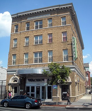
Isaiah T. Hatton (1883–1921) was an architect in the United States known for his designs of buildings for his fellow African Americans. Several are listed on the National Register of Historic Places.

<span class="mw-page-title-main">LGBT culture in Washington, D.C.</span>

In Washington, D.C., LGBT culture is heavily influenced by the U.S. federal government and the many nonprofit organizations headquartered in the city.

<span class="mw-page-title-main">Old Korean Legation Museum</span> Historic house museum in Washington, D.C., US

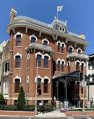
The Old Korean Legation Museum is a historic house museum located at 15 Logan Circle NW in the Logan Circle neighborhood of Washington, D.C. Built in 1877 as a residence for military officer and politician Seth Ledyard Phelps, the house served as the legation for the Joseon kingdom followed by the Korean Empire from 1889 to 1905 when Japan took control of Korea's government. The building was sold in 1910 for $10 and later served as a recreation center for African Americans, trade union hall, and private residence.

<span class="mw-page-title-main">Codman Carriage House and Stable</span> Historic building in Washington, D.C.

The Codman Carriage House and Stable is a historic building located at 1415 22nd Street NW in the Dupont Circle neighborhood of Washington, D.C. The industrial building was constructed in 1907 as a carriage house and stable for socialite and art collector Martha Catherine Codman, who lived a few blocks north in her home, later known as the Codman–Davis House. She commissioned her cousin, Ogden Codman Jr., an architect and prominent interior decorator who also designed her home. He designed it in a Second Empire style.

References

  1. Area in square meters in table showing changes in DC census tracts, 2020 vs. 2010, via https://www.census.gov/geographies/reference-files/time-series/geo/relationship-files.2020.html#tract
  2. 1 2 3 Wellborn, Mark (November 21, 2009). "Trendy now, but not by accident: Residents' efforts paved way in Logan Circle". The Washington Post . washingtonpost.com. pp. F01. Retrieved November 22, 2009.
  3. 1 2 3 4 "Logan Circle Historic District". National Park Service . (nps.gov). Retrieved November 22, 2009.
  4. Bloomberg - America's Wealthiest Neighborhoods
  5. DC Curbed - Mapping D.C.'s most and least expensive neighborhoods for renters
  6. DC Curbed - The Twelve Richest Neighborhoods in D.C. Right Now
  7. Urban Turf - Above $640: Logan Circle, West End Have Highest Price Per Square Foot in DC
  8. DCist - Logan Circle Remains DC's Top Gaye Neighborhood
  9. WUSA9 - Does DC still have a gay neighborhood?
  10. 1 2 3 "Greater 14th Street Historic District". National Park Service . (nps.gov). Retrieved November 22, 2009.
  11. 1 2 3 4 5 "District of Columbia Inventory of Historic Sites" (PDF). District of Columbia Office of Planning: Historic Preservation Office. (planning.dc.gov). September 1, 2009. Archived from the original (PDF) on December 31, 2009. Retrieved November 22, 2009.
  12. Blight, David W. (2007). A Slave No More: Two Men Who Escaped to Freedom, Including Their Own Narratives of Emancipation. Orlando, Florida: Houghton Mifflin Harcourt. pp.  93. ISBN   978-0-15-101232-9.
  13. "Iowa Circle Passes". Washington Evening Star. December 11, 1930. p. 1.
  14. 1 2 Williams, Paul Kelsey (2001). Images of America: The Neighborhoods of Logan, Scott, and Thomas Circles. Charleston, South Carolina: Arcadia Publishing. pp. 9–46. ISBN   978-0-7385-1404-8.
  15. Jacob, Kathryn Allamong; Remsberg, Edwin Harlan (1998). Testament to Union: Civil War monuments in Washington, D.C. Baltimore, Maryland: Johns Hopkins University Press. pp. 83–84. ISBN   978-0-8018-5861-1.
  16. Richburg, Keith B (16 September 1980). "D.C. Plans to Close Section of 13th Street". Washington Post.
  17. 1 2 Moeller, Gerard Martin; Weeks, Christopher (2006). AIA Guide to the Architecture of Washington, D.C. (Fourth ed.). Baltimore: Johns Hopkins University Press. pp.  268–274. ISBN   978-0-8018-8468-9.
  18. Schwartzman, Paul (June 8, 2005). "D.C. Gay Clubs' Vanishing Turf: City Earmarks Block of O Street SE for Stadium". The Washington Post . washingtonpost.com. pp. A01. Retrieved November 23, 2009.
  19. Hahn, Fritz (September 24, 2004). "The Halo Effect". The Washington Post . washingtonpost.com. pp. WE05. Retrieved November 23, 2009.
  20. 1 2 Hull, Anne (April 1, 2001). "Palace of Plenty: Food, Class and the Coming of Fresh Fields to Logan Circle". The Washington Post . washingtonpost.com. pp. W19. Archived from the original on September 27, 2018. Retrieved November 23, 2009.
  21. Chibbaro Jr., Lou (February 15, 2008). "Obama sweep includes 'gay' D.C. precincts". Washington Blade . washblade.com. Archived from the original on July 20, 2008. Retrieved November 23, 2009.
  22. Castro, Melissa (July 25, 2008). "After gay migration, 17th Street seeks a new identity". Washington Business Journal . washington.bizjournals.com. Retrieved November 23, 2009.
  23. Koncius, Jura (May 16, 2007). "Household Names: Prolific Furniture Makers Gold and Williams Are Anonymous No More". The Washington Post . washingtonpost.com. pp. H01. Retrieved November 23, 2009.
  24. Breen, Ann; Rigby, Dick (2004). Intown Living: A Different American Dream. Westport, Connecticut: Greenwood Publishing Group. p. 249. ISBN   978-0-275-97591-3.
  25. "National Register Information System". National Register of Historic Places . National Park Service. March 13, 2009.
  26. "Mary McLeod Bethune House". National Park Service . (nps.gov). Retrieved November 29, 2009.
  27. Whitman, William B. (2007). Washington, D.C.: Off the Beaten Path (Fourth ed.). Guilford, Connecticut: Morris Book Publishing. pp.  186–190. ISBN   978-0-7627-4217-2.
  28. "Washington's Neighborhoods". National Park Service . (nps.gov). Retrieved November 23, 2009.
  29. Brown, T. Robins (July 16, 1973). "National Register of Historic Places Inventory - Nomination Form" (PDF). National Capital Planning Commission . (nps.gov). Retrieved November 23, 2009.
  30. Goode, James M. (1988). Best Addresses: A Century of Washington's Distinguished Apartment Houses (First ed.). Washington, D.C.: Smithsonian Institution Press. ISBN   978-0-87474-477-4.
  31. 1 2 Bednar, Michael J. (2006). L'Enfant's Legacy: Public Open Spaces in Washington. Baltimore: Johns Hopkins University Press. pp. 173–178. ISBN   978-0-8018-8318-7.
  32. "Charles Manuel "Sweet Daddy" Grace Residence". Cultural Tourism DC . (culturaltourismdc.org). Archived from the original on December 3, 2008. Retrieved November 28, 2009.
  33. "John A. Lankford Residence and Office". Cultural Tourism DC . (culturaltourismdc.org). Archived from the original on March 24, 2007. Retrieved November 28, 2009.
  34. Moreno, Sylvia (February 15, 2004). "D.C.'s black heritage, block by block". The Washington Post . sfgate.com. pp. C6. Retrieved November 28, 2009.
  35. "Mary Jane Patterson Residence". Cultural Tourism DC . (culturaltourismdc.org). Archived from the original on March 24, 2007. Retrieved November 28, 2009.
  36. Fleischhauer, Carl; Brannan, Beverly W.; Levine, Lawrence W.; Trachtenberg, Alan (1988). Documenting America, 1935-1943. Berkeley: University of California Press. pp.  227. ISBN   978-0-520-06221-4.
  37. Miller, Fredric; Gillette, Howard (1995). Washington Seen: A Photographic History, 18751965. Baltimore: Johns Hopkins University Press. p. 173. ISBN   978-0-8018-4979-4.
  38. "Belford V. Lawson and Marjorie M. Lawson Residence". Cultural Tourism DC . (culturaltourismdc.org). Archived from the original on March 11, 2007. Retrieved November 28, 2009.
  39. "Alain Locke Residence". Cultural Tourism DC . (culturaltourismdc.org). Archived from the original on March 24, 2007. Retrieved November 28, 2009.
  40. "James Lesesne Wells Residence". Cultural Tourism DC . (culturaltourismdc.org). Archived from the original on March 24, 2007. Retrieved November 28, 2009.
  41. McRae, F. Finley (November 26, 2009). "Four Blacks Named Rhodes Scholars for Next Year". The Washington Informer . washingtoninformer.com. Retrieved November 28, 2009.
  42. Lewis, Samella S. (2003). African American Art and Artists (Third ed.). Berkeley: University of California Press. p. 96. ISBN   978-0-520-23935-7.
  43. Austermuhle, Martin (November 28, 2012). "Korea Reclaims Former Embassy Lost to Japan Over 100 Years Ago". The Washington Diplomat. Retrieved September 27, 2020.
  44. Kerns, Virginia (2003). Scenes From the High Desert: Julian Steward's Life and Theory. Chicago: University of Illinois Press. pp.  196. ISBN   978-0-252-02790-1.
  45. 1 2 Wellborn, Mark (November 21, 2009). "Logan Circle". The Washington Post . washingtonpost.com. pp. F01. Retrieved November 22, 2009.
  46. Muzzy, Frank (2005). Gay and Lesbian Washington, D.C. Charleston, South Carolina: Arcadia Publishing. p. 96. ISBN   978-0-7385-1753-7.
  47. 2020 Census Results by D.C. census tract, U.S. Census Bureau
  48. "Census Tracts in 2010", Open Data DC, D.C. government
  49. "Census Tracts in 2000", Open Data DC, D.C. government
  50. "Census Tracts in 1990", Open Data DC, D.C. government
  51. "Census Tracts in 1980", Open Data DC, D.C. government
  52. "Census Tracts in 1970", Open Data DC, D.C. government
  53. "Census Tracts in 1960", Open Data DC, D.C. government
  54. 2020 Census Results by D.C. census tract, U.S. Census Bureau
  55. "Census Tracts in 2010", Open Data DC, D.C. government
  56. (Map of blocks): "Washington D.C. by census tracts and blocks: 1950, part 7 of 10 parts", in "1950 United States Census of Housing", U.S. Department of Commerce and Bureau of the Census, 1950
  57. Brown, Emma (March 1, 2013). "D.C. parents develop alternatives to chancellor's school-closure plan". Washington Post . Retrieved September 30, 2016.
  58. "Attendance Zones for Neighborhood Elementary & K-8 Schools S.Y. 2013-2014" (Archive). District of Columbia Public Schools. Retrieved on April 14, 2015.
  59. "Attendance Zones for Neighborhood High Schools S.Y. 2013-2014" (Archive). District of Columbia Public Schools. Retrieved on April 14, 2015.
  60. Nixon, Rob (March 25, 2007). "African, American". The New York Times Book Review . nytimes.com. pp. BR1. Retrieved November 22, 2009.
  61. "'The Prince of Chocolate City': When Gil Scott-Heron Became A Music Icon| Daily Beast".