Washington Heights is a neighborhood in the northern portion of the New York City borough of Manhattan. It is named for Fort Washington, a fortification constructed at the highest natural point on Manhattan Island by Continental Army troops during the American Revolutionary War, to defend the area from the British forces. Washington Heights is bordered by Inwood to the north along Dyckman Street, Harlem to the south along 155th Street, the Harlem River and Coogan's Bluff to the east, and the Hudson River to the west. As of 2016, it has a population of 201,590.

Downtown Pittsburgh, colloquially referred to as the Golden Triangle, and officially the Central Business District, is the urban downtown center of Pittsburgh. It is located at the confluence of the Allegheny River and the Monongahela River whose joining forms the Ohio River. The "triangle" is bounded by the two rivers. The area features offices for major corporations such as PNC Bank, U.S. Steel, PPG, Bank of New York Mellon, Heinz, Federated Investors and Alcoa. It is where the fortunes of such industrial barons as Andrew Carnegie, Henry Clay Frick, Henry J. Heinz, Andrew Mellon and George Westinghouse were made. It contains the site where the French fort, Fort Duquesne, once stood.

Northeast is the northeastern quadrant of Washington, D.C., the capital of the United States. It encompasses the area located north of East Capitol Street and east of North Capitol Street.

Neighborhoods in Washington, D.C., are distinguished by their history, culture, architecture, demographics, and geography. The names of 131 neighborhoods are unofficially defined by the D.C. Office of Planning. Neighborhoods can be defined by the boundaries of wards, historic districts, Advisory Neighborhood Commissions, civic associations, and business improvement districts (BIDs); these boundaries will overlap. The eight wards each elect a member to the Council of the District of Columbia and are redistricted every ten years.

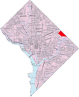
Woodridge is a residential neighborhood located in Ward 5 of Northeast Washington, D.C.. Woodridge is contained between Eastern Avenue N.E. to the east, Taylor Street N.E. to the north, South Dakota Avenue N.E. to the west, and Bladensburg Road N.E. to the south. Its central commercial strips are Rhode Island Avenue NE and Bladensburg Road N.E. Woodridge borders the adjacent neighborhoods of Brookland, Langdon, North Michigan Park, and Fort Lincoln in Northeast Washington D.C. In addition to these neighborhoods in the District of Columbia, Woodridge also borders the city of Mount Rainier and town of Cottage City in Maryland. In terms of public transportation, residents of Woodridge have access to the Brookland-CUA and Rhode Island Avenue Metro stations.

H Street is a set of east-west streets in several of the quadrants of Washington, D.C. It is also used as an alternate name for the Near Northeast neighborhood, as H Street NW/NE is the neighborhood's main commercial strip.

Florida Avenue is a major street in Washington, D.C. It was originally named Boundary Street, because it formed the northern boundary of the Federal City under the 1791 L'Enfant Plan. With the growth of the city beyond its original borders, Boundary Street was renamed Florida Avenue in 1890.

Brightwood is a neighborhood located in the northwestern quadrant of Washington, D.C. Brightwood is part of Ward 4.

Fort Totten is a neighborhood located in Ward 5 of Northeast Washington, D.C.
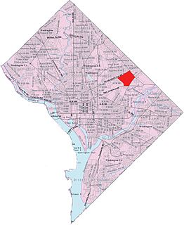
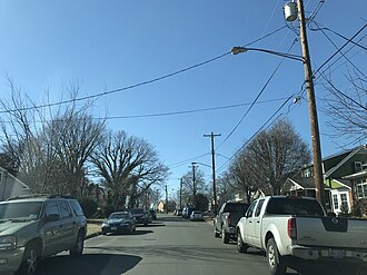
Langdon, also referred to as, "South Woodridge", is a neighborhood located in Ward 5 of Northeast Washington, D.C. Historical surveys of D.C. recognize Langdon as a neighborhood dating back to at least 1903. Langdon is bounded by Montana Ave. NE to the west/southwest, New York Ave. NE to the south, Bladensburg Rd. NE to the southeast, South Dakota Ave. NE to the northeast, and Rhode Island Ave. NE to the north/northwest. Langdon is adjacent to the Northeast D.C. neighborhoods of Brentwood (west), Woodridge (east), Fort Lincoln (southeast), Gateway (south), and Brookland (north).
U.S. Route 50 (US 50) is a major east–west route of the U.S. Highway system, stretching just over 3,000 miles (4,800 km) from Ocean City, Maryland, on the Atlantic Ocean, to West Sacramento, California, nearly to the Pacific Ocean. In the District of Columbia, US 50 passes between Arlington County, Virginia, and Prince George's County, Maryland, predominantly along surface streets, including a part of Constitution Avenue along the National Mall.

Community boards of Manhattan are New York City community boards in the borough of Manhattan, which are the appointed advisory groups of the community districts that advise on land use and zoning, participate in the city budget process, and address service delivery in their district.

Fairlawn is a working class and middle class residential neighborhood located in southeast Washington, D.C., United States. It is bounded by Interstate 295, Pennsylvania Avenue SE, Minnesota Avenue SE, Naylor Road SE, and Good Hope Road SE.
Fort Lincoln is a neighborhood located in northeastern Washington, D.C. It is bounded by Bladensburg Road to the northwest, Eastern Avenue to the northeast, New York Avenue NE to the south, and South Dakota Avenue NE to the southwest. The town of Colmar Manor, Maryland, is across Eastern Avenue from the Fort Lincoln neighborhood, as is the Fort Lincoln Cemetery.

Northeast Boundary is small neighborhood located in the northeast quadrant of Washington, D.C., in the United States. Along with the Capitol View neighborhood, it is the easternmost neighborhood of the District of Columbia.

The following outline is provided as an overview of and topical guide to Washington, D.C.: