Chillum is an unincorporated area in Prince George's County, Maryland, United States, bordering Washington, D.C. and Montgomery County. Chillum is contained between the Northwest Branch Anacostia River to the east, East West Highway and the Sligo Creek River to the north, New Hampshire Avenue to the west, and Eastern Avenue NE to the south. Chillum borders the adjacent communities of Avondale, Green Meadows, and Carole Highlands in Prince George's County as well as the city of Takoma Park in Montgomery County, and the Riggs Park, Queens Chapel, and North Michigan Park neighborhoods of Northeast Washington D.C. The population was 33,513 at the 2010 census. In addition to being its own unincorporated neighborhood, Chillum is also considered to be its own Census Designated Place in Prince George's County. As of the 2000 census, the Chillum CDP included Chillum, as well as the adjacent unincorporated communities of Avondale, Carole Highlands, Green Meadows and Lewisdale.

The Territory of Nebraska was an organized incorporated territory of the United States that existed from May 30, 1854, until March 1, 1867, when the final extent of the territory was admitted to the Union as the State of Nebraska. The Nebraska Territory was created by the Kansas–Nebraska Act of 1854. The territorial capital was Omaha. The territory encompassed areas of what is today Nebraska, Wyoming, South Dakota, North Dakota, Colorado, and Montana.

Southeast is the southeastern quadrant of Washington, D.C., the capital of the United States, and is located south of East Capitol Street and east of South Capitol Street. It includes the Capitol Hill and Anacostia neighborhoods, the Navy Yard, the Joint Base Anacostia-Bolling (JBAB), the U.S. Marine Barracks, the Anacostia River waterfront, Eastern Market, the remains of several Civil War-era forts, historic St. Elizabeths Hospital, RFK Stadium, Nationals Park, and the Congressional Cemetery. It is also contains a landmark known as "The Big Chair," located on Martin Luther King Jr. Avenue. The quadrant is split by the Anacostia River, with the portion that is west of the river sometimes referred to as "Near Southeast". Geographically, it is the smallest quadrant of the city.
Northeast is the northeastern quadrant of Washington, D.C., the capital of the United States. It encompasses the area located north of East Capitol Street and east of North Capitol Street.
Benning Road is a major traveled street in Washington, D.C., and Prince George's County, Maryland.

New York Avenue is diagonal avenue radiating northeast from the White House in Washington, D.C., to the border with Maryland. It is a major east–west route in the city's Northwest and Northeast quadrants and connects downtown with points east and north of the city via Cheverly, Maryland, the John Hanson Highway, the Baltimore–Washington Parkway, and eventually Interstate 95.

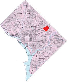
Woodridge is a residential neighborhood located in Ward 5 of Northeast Washington, D.C.. Woodridge is contained between Eastern Avenue N.E. to the east, Taylor Street N.E. to the north, South Dakota Avenue N.E. to the west, and Bladensburg Road N.E. to the south. Its central commercial strips are Rhode Island Avenue NE and Bladensburg Road N.E. Woodridge borders the adjacent neighborhoods of Brookland, Langdon, North Michigan Park, and Fort Lincoln in Northeast Washington D.C. In addition to these neighborhoods in the District of Columbia, Woodridge also borders the city of Mount Rainier and town of Cottage City in Maryland. In terms of public transportation, residents of Woodridge have access to the Brookland-CUA and Rhode Island Avenue Metro stations.

Florida Avenue is a major street in Washington, D.C. It was originally named Boundary Street, because it formed the northern boundary of the Federal City under the 1791 L'Enfant Plan. With the growth of the city beyond its original borders, Boundary Street was renamed Florida Avenue in 1890.

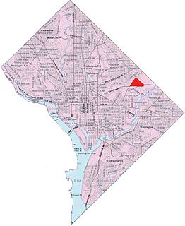
Michigan Park is a neighborhood in Ward 5 of Northeast Washington, D.C. in the Upper Northeast area element. The boundaries of Michigan Park and North Michigan Park neighborhoods are contested due to the history of racial disparity between the two, but in general Michigan Park is considered to be contained between South Dakota Avenue to the west, Eastern Avenue to the east, Galloway Street NE to the north and Taylor Street NE to the South. Both neighborhoods are in DC Neighborhood Cluster 20 along with the University Heights neighborhood. Michigan Park is home to two established Civic Associations: the North Michigan Park Civic Association which has its established boundaries that include both Michigan Park and North Michigan Park and the Queens Chapel Civic Association. The Queens Chapel association meets regularly at Union Wesley African Methodist Zion Church and its boundaries are between 16th Street NE and Webster Street NE to the north, Michigan Avenue NE to the south, and South Dakota Avenue NE to the west.
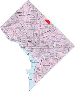
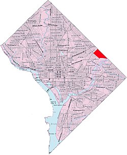
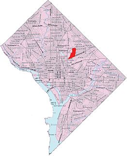
North Michigan Park is a neighborhood located in Ward 5 of Northeast Washington, D.C.. North Michigan Park is contained between Eastern Avenue N.E. to the east, Gallatin Street N.E. to the north, Michigan Avenue N.E. to the south, and South Dakota Avenue N.E. to the west. North Michigan Park borders the neighborhoods of Michigan Park, Queens Chapel, and Woodridge, which also are located in Ward 5 of Northeast Washington D.C. In addition to these neighborhoods in Ward 5 of Northeast Washington D.C., North Michigan Park also borders the adjacent neighborhoods of Avondale and Chillum, which are both located in Prince George's County, Maryland. North Michigan Park neighborhood is often confused with the North Michigan Park Civic Association which has boundaries that include both North Michigan Park and Michigan Park. North Michigan Park and Michigan Park neighborhoods have been historically designated as separate neighborhoods due to the fact that they were segregated by race. North Michigan Park was the less desirable neighborhood where African-Americans lived while Michigan Park was a much more desirable neighborhood where the neighborhood where their white counterparts lived. Both neighborhoods are separated from each other by South Dakota Avenue N.E. The Washington Metropolitan Area Green Line train tracks pass through the North Michigan Park neighborhood, notably, through a tunnel when traveling between the West Hyattsville and Fort Totten Metro Stations. The Washington Metropolitan Area Green Line train tracks initially are above ground when traveling between the West Hyattsville Metro Station and a certain portion of the neighborhood of Avondale. The Washington Metropolitan Area Green Line tracks then gradually enter a tunnel, which they use throughout the rest of the Avondale neighborhood, a small portion of the Chillum neighborhood, the North Michigan Park neighborhood, and Queens Chapel neighborhood before entering the lower level portion of the Fort Totten Metro Station, located below the Washington Metropolitan Area Red Line train tracks.
Gateway is the name of a small industrial and residential neighborhood in Northeast Washington, D.C. It is bounded by New York Avenue NE to the south and southeast, Bladensburg Road to the west, and South Dakota Avenue to the northeast. Gateway is across New York Avenue from the U.S. National Arboretum.
Langdon, also referred to as, "South Woodridge", is a neighborhood located in Ward 5 of Northeast Washington, D.C. Historical surveys of D.C. recognize Langdon as a neighborhood dating back to at least 1903. Langdon is bounded by Montana Ave. NE to the west/southwest, New York Ave. NE to the south, Bladensburg Rd. NE to the southeast, South Dakota Ave. NE to the northeast, and Rhode Island Ave. NE to the north/northwest. Langdon is adjacent to the Northeast D.C. neighborhoods of Brentwood (west), Woodridge (east), Fort Lincoln (southeast), Gateway (south), and Brookland (north).
Edgewood is a neighborhood located in Ward 5 of Northeast Washington, D.C. Edgewood is bounded by Michigan Avenue NE to the north, Rhode Island Avenue NE to the south, North Capitol Street to the west, and the Washington Metro's Red Line to the east. The eastern boundary originates with the establishment of the former Metropolitan Branch of the Baltimore and Ohio Railroad in 1873, creating the physical barrier which today separates Edgewood from Brookland to the east.

Stanton Park previously known as Stanton Square is a national park in Washington D.C. It is located at the intersection of Maryland Avenue and Massachusetts Avenue in the Capitol Hill neighborhood of Northeast, Washington, D.C. It is bounded by 4th Street to the west and 6th Street to the east. North and south of the park are the respective westbound and eastbound lanes of C Street, NE.

Riggs Park, also known as "Lamond Riggs", is a residential neighborhood in Ward 4 of Northeast Washington, D.C.. Riggs Park is contained between Eastern Avenue N.E. to the east, Riggs Road N.E. to the south, North Capitol Street N.W. to the north and west, and the Blair Road Community Garden to the north. Riggs Park is adjacent to the neighborhoods of Queens Chapel, North Michigan Park, and Fort Totten, located in Ward 5 of Northeast Washington D.C.. In addition to these neighborhoods, Riggs Park also borders the city/neighborhood Chillum, which is located in Prince George's County, Maryland. The WMATA Red Line train tracks pass through the Riggs Park neighborhood when traveling between the Takoma and Fort Totten Metro Stations. In addition to the WMATA Red Line, the CSX, MARC, and Amtrak train tracks, pass through the Riggs Park neighborhood as well.

Northeast Boundary is small neighborhood located in the northeast quadrant of Washington, D.C., in the United States. Along with the Capitol View neighborhood, it is the easternmost neighborhood of the District of Columbia.
Eastern Avenue is one of three boundary streets between Washington, D.C., and the state of Maryland. It follows a northwest-to-southeast line, beginning at the intersection of 16th Street NW and Colesville Road. It intersects with Blair Road NW, and ceases to exist for about 1,000 feet (300 m). Another interruption occurs at Cedar Street NW. A 3,000-foot (910 m) interruption occurs again at Galloway Street NE, where the park land of the North Michigan Park Recreation Center exists. It continues without interruption until it reaches Bladensburg Road NE. There is a 1.8-mile (2.9 km) interruption in the avenue along Fort Lincoln Cemetery. The avenue has no crossing over New York Avenue NE or the Anacostia River, or through Anacostia Park. It resumes at Kenilworth Avenue NE, with its terminus at its junction with Southern Avenue.

Avondale is an unincorporated community in Prince George's County Maryland, United States. It is contained between Eastern Avenue NE to the south, Queens Chapel Road (MD-500) to the east, and the Northwest Branch Anacostia River to the north and west.

Western Avenue is one of three boundary streets between Washington, D.C., and the state of Maryland. It follows a southwest-to-northeast line, beginning at Westmoreland Circle in the south and ending at Oregon Avenue NW in the north. It is roughly 3.5 miles (5.6 km) in length. First proposed in 1893, it was constructed somewhat fitfully from about 1900 to 1931.

The Starburst Intersection refers to the intersection of six streets in northeast Washington, DC. Bladensburg Road NE, Benning Road NE, 15th Street NE, Maryland Avenue NE and H Street NE intersect directly, and to the immediate northwest of this intersection is the easternmost point of Florida Avenue. The name "starburst" refers to the star-like shape created by these roads when viewed on a map.