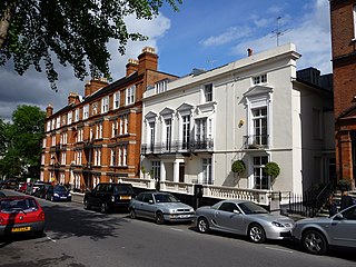
Hampstead is an area in London, which lies 4 miles (6.4 km) northwest of Charing Cross, and extends from the A5 road to Hampstead Heath, a large, hilly expanse of parkland. The area forms the northwest part of the London Borough of Camden, a borough in Inner London which for the purposes of the London Plan is designated as part of Central London.

Dupont Circle is a traffic circle, park, neighborhood, and historic district in Northwest Washington, D.C. The Dupont Circle neighborhood is bounded approximately by 16th Street NW to the east, 22nd Street NW to the west, M Street NW to the south, and Florida Avenue NW to the north. Much of the neighborhood is listed on the National Register of Historic Places. However, the local government Advisory Neighborhood Commission and the Dupont Circle Historic District have slightly different boundaries.

Mount Pleasant is a neighborhood in the northwestern quadrant of Washington, D.C. It is bounded by Rock Creek Park to the north and west; Harvard Street NW to the south; and 16th Street NW to the east. It is north of Adams Morgan and west of Columbia Heights. It is home to approximately 10,000 people.
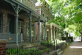
Powelton Village is a neighborhood of mostly Victorian, mostly twin homes in the West Philadelphia section of the United States city of Philadelphia, Pennsylvania. It is a national historic district that is part of University City. It extends north from Market Street to Spring Garden Street, east to 32nd Street, west to 40th and Spring Garden Streets, and to 44th and Market Streets.

Northwest is the northwestern quadrant of Washington, D.C., the capital of the United States, and is located north of the National Mall and west of North Capitol Street. It is the largest of the four quadrants of the city, and it includes the central business district, the Federal Triangle, and the museums along the northern side of the National Mall, as well as many of the District's historic neighborhoods.

Chestnut Hill is an affluent New England village located six miles (9.7 km) west of downtown Boston, Massachusetts, United States. Like all Massachusetts villages, Chestnut Hill is an incorporated municipal entity. It is located partially in Brookline in Norfolk County; partially in the city of Boston in Suffolk County, and partially in the city of Newton in Middlesex County. Chestnut Hill's borders are defined by the 02467 ZIP Code. The name refers to several small hills that overlook the 135-acre Chestnut Hill Reservoir rather than one particular hill. Chestnut Hill is best known as the home of Boston College and as part of the Boston Marathon route.

Massachusetts Avenue is a major diagonal transverse road in Washington, D.C., and the Massachusetts Avenue Historic District is a historic district that includes part of it.

Brewerytown is a neighborhood in the North Philadelphia section of Philadelphia, Pennsylvania, United States. An unofficial region, Brewerytown runs approximately between the Schuylkill River's eastern bank and 25th Street, bounded by Cecil B. Moore Avenue to the north and Parrish Street to the south. Brewerytown got its name because of the numerous breweries that were located along the Schuylkill during the late 19th century and early 20th century. It is now primarily a residential neighborhood, with a growing and active commercial sector along Girard Avenue.

Petworth is a residential neighborhood in the Northwest quadrant of Washington, D.C. It is bounded to the east by the Armed Forces Retirement Home and Rock Creek Cemetery, to the west by Arkansas Avenue NW, to the south by Rock Creek Church Road NW and Spring Road NW, and to the north by Kennedy Street NW.
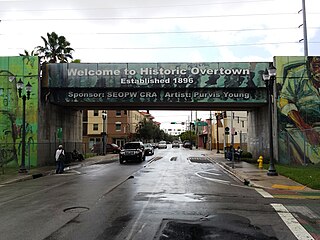
Overtown is a neighborhood of Miami, Florida, United States, just northwest of Downtown Miami. Originally called Colored Town during the Jim Crow era of the late 19th through the mid-20th century, the area was once the preeminent and is the historic center for commerce in the black community in Miami and South Florida.

Harry Wardman was a real estate developer in Washington, D.C. during the early 20th century whose developments included landmark hotels, luxury apartment buildings, and many rowhouses. When he died in 1938, one-tenth of the residents of Washington were said to live in a Wardman-built home.
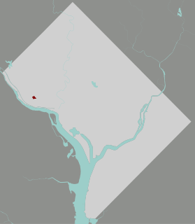
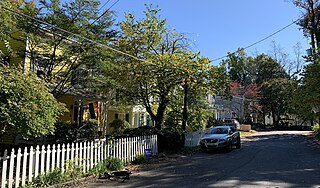
Colony Hill is a small neighborhood located in the southwest corner of Glover Archbold Park in Northwest Washington, D.C. It is bounded on the north and east by the park, on the south by Reservoir Road NW, and on the west by Foxhall Road NW. Colony Hill falls within Ward 3.
Eastern Avenue is one of three boundary streets between Washington, D.C., and the state of Maryland. It follows a northwest-to-southeast line, beginning at the intersection of 16th Street NW and Colesville Road. It intersects with Blair Road NW, and ceases to exist for about 1,000 feet (300 m). Another interruption occurs at Cedar Street NW. A 3,000-foot (910 m) interruption occurs again at Galloway Street NE, where the park land of the North Michigan Park Recreation Center exists. It continues without interruption until it reaches Bladensburg Road NE. There is a 1.8-mile (2.9 km) interruption in the avenue along Fort Lincoln Cemetery. The avenue has no crossing over New York Avenue NE or the Anacostia River, or through Anacostia Park. It resumes at Kenilworth Avenue NE, with its terminus at its junction with Southern Avenue.
The Grant Road Historic District is located in the Tenleytown neighborhood of Washington, D.C.. The two-block historic district is what remains of a former settlement in rural Washington County in the District of Columbia. It includes 13 contributing buildings and the road itself, a narrow remnant of a country road that was used by soldiers in the Civil War. Following the war, the road was named after Civil War general and President Ulysses S. Grant. Grant Road developed into a residential street lined with mostly small, two-story homes for working-class people.

Mount Vernon Triangle is a neighborhood and community improvement district in the northwest quadrant of Washington, D.C. Originally a working-class neighborhood established in the 19th century, present-day Mount Vernon Triangle experienced a decline in the mid-20th century as it transitioned from residential to commercial and industrial use. The neighborhood has undergone significant and rapid redevelopment in the 21st century. It now consists mostly of high-rise condominium, apartment and office buildings. Several historic buildings in the neighborhood have been preserved and are listed on the National Register of Historic Places. Mount Vernon Triangle is now considered a good example of urban planning and a walkable neighborhood.

George S. Cooper was an American architect and builder from Washington, D.C. During his 40-year career, he was responsible for designing around 850 properties, including homes, commercial buildings and apartment buildings, several of which are listed on the National Register of Historic Places (NRHP). The 1903 book History of the City of Washington states: "It may be thought that Mr. Cooper's forte lies in the designing of apartment houses, since the handsomest in the city are a result of his genius..." and "No young man has played a more important part in the active growth and great development of Greater Washington than George S. Cooper..."

Readingsburg, also known as Stone Mill, is an unincorporated community located along the South Branch Raritan River within Clinton Township in Hunterdon County, New Jersey.

Appleton Prentiss Clark Jr. was an American architect from Washington, D.C. During his 60-year career, Clark was responsible for designing hundreds of buildings in the Washington area, including homes, hotels, churches, apartments and commercial properties. He is considered one of the city's most prominent and influential architects from the late 19th and early 20th centuries. Many of his designs are now listed on the National Register of Historic Places (NRHP).
MacArthur Boulevard is a road in Montgomery County, Maryland and Washington, D.C. The road follows a northwest–southeast route from the Great Falls area of the Chesapeake and Ohio Canal National Historical Park in Potomac, Maryland, to Foxhall Road NW and 44th Street NW in the Foxhall neighborhood of Washington, D.C., near the Georgetown Reservoir. MacArthur Boulevard runs parallel to the Clara Barton Parkway and the C&O Canal for most of its route, passing through the Palisades area of the District. In Cabin John, traffic is reduced to a single alternating lane as it passes over the Union Arch Bridge, the longest span masonry arch bridge in the Western Hemisphere, and which also carries the Washington Aqueduct.

Old Bridge, also known as the Historic Village of Old Bridge, is an unincorporated community located within East Brunswick in Middlesex County, New Jersey. It is on the South River, a tributary of the Raritan River. The community is named after the first bridge built here to cross the river, the South River Bridge. After other bridges were built crossing the river, it became known as the Old Bridge. The Old Bridge Historic District, encompassing much of the village, is listed on the state and national registers of historic places.
 Houses in 2014
 Houses in 2019
 Houses on Foxhall Road in 2022
 Houses on 44th St NW in 2022
 Houses with 'Foxhall chimneys' on 44th St NW in 2022


