Truxton Circle

Last updated
Truxton Circle
MG 5348 (8374169161).jpg
12.TruxtonCircle.WDC.10feb06 (99604118) (cropped).jpg
33.TruxtonCircle.WDC.10feb06 (101897454) (cropped).jpg
Armstrong Manual Training School.jpg
Map truxton circle.jpg
Truxton Circle within the District of Columbia
Coordinates: 38°54′40″N77°00′32″W / 38.911056°N 77.008972°W / 38.911056; -77.008972
Country United States
District Washington, D.C.
WardWard 5
Government
  Councilmember Zachary Parker

Truxton Circle, sometimes known as East Shaw, [1] [2] [3] is a neighborhood of Washington, D.C., located in Northwest D.C.

Contents

History

Dunbar High School Dunbar High School DC (new building).jpg
Dunbar High School
Historic rowhouses 14.TruxtonCircle.WDC.10feb06 (99640134).jpg
Historic rowhouses

Truxton Circle is named for the former Thomas Truxtun traffic circle, which was constructed at the intersection of Florida Avenue and North Capitol Street around 1900. [4] The circle was named after US Navy Commodore Thomas Truxtun. [4] It was part of the Shaw School Urban Renewal Area, [5] later known as the Shaw neighborhood. [6]

A fountain was moved from the intersection of Pennsylvania Avenue and M Street NW to Truxton Circle in 1901. [7] [8]

A police officer conducted traffic at the traffic circle until a traffic light was installed in 1925. [9]

Because the traffic circle was a site of traffic jams and accidents, it was demolished in 1947 at a cost of $500,000. [4] [10] The adjacent fountain was removed at the same time. [4]

The neighborhood of Truxton Circle contains late 19th-century houses and historical schools, including Armstrong Manual Training School (where Duke Ellington graduated) and the original Dunbar High School, the first public high school for black students in the United States. Along with Armstrong, the former John Mercer Langston School, John Fox Slater Elementary School, and the Margaret Murray Washington School buildings are all listed on the National Register of Historic Places.

Geography

Third Baptist Church ThirdBaptistChurchDC.JPG
Third Baptist Church

Truxton Circle is bordered by New Jersey Avenue to the west; Florida Avenue to the north; New York Avenue to the south; and North Capitol Street to the east.

It is bordered by the following neighborhoods: to the north by Bloomingdale and LeDroit Park; to the east by Eckington; to the west by Shaw and Mt. Vernon Square Historic District; and to the south by NoMa.

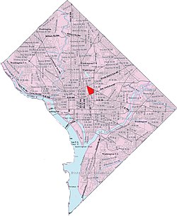
A majority of Truxton Circle is defined as within Ward 5 of the city, with the southeast corner bounded by Kirby St and N St part of Ward 6. After the 2012 redistricting, the Ward 5 portions moved from ANC-5C to ANC-5E. The neighborhood is now served by two Single-Member Districts, 5E05 (south of Q St) and 5E06 (north of Q St and shared with Bloomingdale). [11]

The neighborhood has several parks and playgrounds, such as Truxton Park, which lies at the corner of First Street and Florida Avenue, New York Avenue Playground at the corner of First Street and N Street, and Bundy Playground between O Street and P Street.

Civic association

Truxton Circle is home to two civic associations, the Bates Area Civic Association and the Hanover Civic Association. [12]

Notes

  1. Bates Civic Association - East Shaw History
  2. Truxton Circle: A Disputed Name and No Circle
  3. Washington Examiner - Truxton Circle: An identity all its own
  4. 1 2 3 4 "Truxton Circle Hazard To End This Summer". Evening Star. March 24, 1947. p. 5.
  5. Miller, James A. (2010). "Greater Shaw: A Gathering Place for Black Washington". In Smith, Kathryn Schneider (ed.). Washington at Home: An Illustrated History of Neighborhoods in the Nation's Capital (2nd ed.). Baltimore: Johns Hopkins University Press. p. 196. ISBN   9780801893537.
  6. Melder, Keith E.; Share, Peter H.; Smith, Kathryn Schneider (1997). City of Magnificent Intentions: A History of the District of Columbia (2nd ed.). Washington: Intac. p. 466. ISBN   0913137006. OCLC   10330671.
  7. "M Street Fountain Moved to New Site." Washington Post. April 23, 1901. p. 10.
  8. "Mr. MacFarland Their Guest: Commends Interest of Citizens' Association in Public Affairs." Washington Post (May 28, 1901): p. 8.
  9. "Auto Signal Lights to Be Ready Dec. 15: Sixteenth Street Crossings and Truxton Circle to Be Equipped." Washington Post (November 14, 1925): p. 20.
  10. "D.C. Spending Millions to Solve Problem of L'Enfant's Circles". Evening Star. February 20, 1949. p. 4.
  11. "ANC 5E Map" (PDF). Retrieved 31 December 2012.
  12. Zafar, Nina. "Truxton Circle: The Old and the New D.C. Mix in a Lively NW Enclave," Washington Post (April 4, 2019).

Related Research Articles

<span class="mw-page-title-main">Dupont Circle</span> Place in the United States

Dupont Circle is a historic roundabout park and neighborhood of Washington, D.C., located in Northwest D.C. The Dupont Circle neighborhood is bounded approximately by 16th Street NW to the east, 22nd Street NW to the west, M Street NW to the south, and Florida Avenue NW to the north. Much of the neighborhood is listed on the National Register of Historic Places. However, the local government Advisory Neighborhood Commission and the Dupont Circle Historic District have slightly different boundaries.

<span class="mw-page-title-main">Northwest (Washington, D.C.)</span> Quadrant in the United States

Northwest is the northwestern quadrant of Washington, D.C., the capital of the United States, and is located north of the National Mall and west of North Capitol Street. It is the largest of the four quadrants of the city, and it includes the central business district, the Federal Triangle, and the museums along the northern side of the National Mall, as well as many of the District's historic neighborhoods.

<span class="mw-page-title-main">Friendship Heights</span> Neighborhood in Ward 3, United States

Friendship Heights is an urban commercial and residential neighborhood in northwest Washington, D.C., and southern Montgomery County, Maryland. Though its borders are not clearly defined, Friendship Heights consists roughly of the neighborhoods and commercial areas around Wisconsin Avenue north of Fessenden Street NW and Tenleytown to Somerset Terrace and Willard Avenue in Maryland, and from River Road in the west to Reno Road and 41st Street in the east. Within Maryland west of Wisconsin Avenue is the Village of Friendship Heights, technically a special taxation district.

<span class="mw-page-title-main">Shaw (Washington, D.C.)</span> Neighborhood of Washington, D.C.

Shaw is a neighborhood of Washington, D.C., located in the Northwest quadrant. Shaw is a major entertainment and retail hub, and much of the neighborhood is designated as a historic district, including the smaller Blagden Alley-Naylor Court Historic District. Shaw and the U Street Corridor have historically have been the city's hub for African-American social, cultural, and economic life.

<span class="mw-page-title-main">Eckington (Washington, D.C.)</span> Place in the United States

Eckington is a neighborhood in Northeast Washington, D.C., located south of the Prospect Hill and Glenwood Cemeteries. Eckington is less than one mile (1.6 km) southeast of Howard University and exactly one mile north of the United States Capitol. Eckington is also the home of the District of Columbia office of Sirius XM Radio.

<span class="mw-page-title-main">LeDroit Park</span> Neighborhood of Washington, D.C.

LeDroit Park is a neighborhood in Washington, D.C. located immediately southeast of Howard University. Its borders include W Street to the north, Rhode Island Avenue and Florida Avenue to the south, Second Street NW to the east, and Howard University to the west. LeDroit Park is known for its history and 19th century protected architecture. The community's diversity entices new residents to the community, as well as its close proximity to the Shaw–Howard University Metro station and many dining options.

<span class="mw-page-title-main">Neighborhoods in Washington, D.C.</span>

Neighborhoods in Washington, D.C., United States are distinguished by their history, culture, architecture, demographics, and geography. The names of 131 neighborhoods are unofficially defined by the D.C. Office of Planning. Neighborhoods can be defined by the boundaries of wards, historic districts, Advisory Neighborhood Commissions, civic associations, and business improvement districts (BIDs); these boundaries will overlap. The eight wards each elect a member to the Council of the District of Columbia and are redistricted every ten years.

<span class="mw-page-title-main">Bloomingdale (Washington, D.C.)</span> Place in the United States

Bloomingdale is a neighborhood in the Northwest quadrant of Washington, D.C., less than two miles (3 km) north of the United States Capitol building. It is a primarily residential neighborhood, with a small commercial center near the intersection of Rhode Island Avenue and First Street NW featuring bars, restaurants, and food markets.

<span class="mw-page-title-main">Mount Vernon Square</span> United States historic place

Mount Vernon Square is a city square and neighborhood in the Northwest quadrant of Washington, D.C. The square is located where the following streets would otherwise intersect: Massachusetts Avenue NW, New York Avenue NW, K Street NW, and 8th Street NW.

<span class="mw-page-title-main">Rhode Island Avenue</span>

Rhode Island Avenue is a diagonal avenue in the Northwest and Northeast quadrants of Washington, D.C., and the capital's inner suburbs in Prince George's County, Maryland. Paralleling New York Avenue, Rhode Island Avenue was one of the original streets in Pierre L'Enfant's plan for the capital. It became a major commuter route, carrying U.S. Route 1 traffic into the city from Prince George's County.

<span class="mw-page-title-main">Florida Avenue</span>

Florida Avenue is a major street in Washington, D.C. It was originally named Boundary Street, because it formed the northern boundary of the Federal City under the 1791 L'Enfant Plan. With the growth of the city beyond its original borders, Boundary Street was renamed Florida Avenue in 1890.

<span class="mw-page-title-main">Pleasant Plains (Washington, D.C.)</span> Neighborhood of Washington, D.C.

Pleasant Plains is a neighborhood in central Washington, D.C. largely occupied by Howard University. For this reason it is also sometimes referred to as Howard Town or, less frequently, Howard Village.

<span class="mw-page-title-main">Thomas Circle</span> Traffic circle

Thomas Circle is a traffic circle in Northwest Washington, D.C., in the United States. It is located at the intersection of Massachusetts Avenue NW, Vermont Avenue NW, 14th Street NW, and M Street NW. It is named for George Henry Thomas, a Union Army general in the American Civil War.

<span class="mw-page-title-main">Kingman Park</span> Place in the United States

Kingman Park is a residential neighborhood in the Northeast quadrant of Washington, D.C., the United States capital city. Kingman Park's boundaries are 15th Street NE to the west; C Street SE to the south; Benning Road to the north; and Anacostia Park to the east. The neighborhood is composed primarily of two-story brick rowhouses. Kingman Park is named after Brigadier General Dan Christie Kingman, the former head of the United States Army Corps of Engineers.

<span class="mw-page-title-main">Barney Circle</span> Neighborhood in the United States

Barney Circle is a small residential neighborhood located between the west bank of the Anacostia River and the eastern edge of Capitol Hill in southeast Washington, D.C., in the United States. The neighborhood is characterized by its sense of community, activism, walkability, and historic feel. The neighborhood's name derives from the eponymous former traffic circle Pennsylvania Avenue SE just before it crosses the John Philip Sousa Bridge over the Anacostia. The traffic circle is named for Commodore Joshua Barney, Commander of the Chesapeake Bay Flotilla in the War of 1812.

<span class="mw-page-title-main">Anna J. Cooper Circle</span>

Anna J. Cooper Circle is a traffic circle and park at the intersection of 3rd and T Streets, Northwest, in the historic LeDroit Park neighborhood of Washington, D.C. In 1983, the circle was named in honor of Anna Julia Haywood Cooper (1858–1964), an author, educator, feminist, and influential African American scholar who once lived in LeDroit Park. The circle is the city's only roundabout named after a woman and serves as a focal point for the LeDroit Park Historic District. The park includes a sign providing historical information about Cooper.

<span class="mw-page-title-main">Randle Highlands</span> Place in the United States

Randle Highlands is a neighborhood in Southeast Washington, D.C., east of the Anacostia River.

<span class="mw-page-title-main">North Capitol Street</span> Street in Washington, D.C.

North Capitol Street is a street in Washington, D.C. that separates the Northwest and Northeast quadrants of the city.

<span class="mw-page-title-main">Shaw Junior High School</span> United States historic place

Shaw Junior High School, now known as Asbury Dwellings, is a historic structure located in the Shaw neighborhood of Washington, D.C. It has been listed on the District of Columbia Inventory of Historic Sites and on the National Register of Historic Places since 2008.

Julius Germuiller, also spelled Julius Germüller, was a German-American architect from Washington, D.C. Throughout his 44-year career, he designed hundreds of buildings, mostly row houses. His work included designs in every quadrant of the city and a large number of his buildings are still extant. One of his works is listed on the National Register of Historic Places (NRHP).