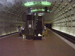
Benning Road is an island-platformed Washington Metro station in the Benning Ridge neighborhood of Northeast Washington, D.C., United States. The station was opened on November 22, 1980, and is operated by the Washington Metropolitan Area Transit Authority (WMATA). Providing service for the Blue and Silver Lines, the station is located in a residential area near the intersection of Benning Road and East Capitol Street. It is the first station after the Blue and Silver Lines diverge from the Orange Line east of the Anacostia River, and also the last station in the District of Columbia going east.

Minnesota Avenue is an island-platformed Washington Metro station in the Central Northeast/Mahaning Heights neighborhood of Northeast Washington, D.C., United States. The station was opened on 20 November 1978, and is operated by the Washington Metropolitan Area Transit Authority (WMATA).

Deanwood is an island-platformed Washington Metro station in the Deanwood neighborhood of Northeast Washington, D.C., United States. The station was opened on November 20, 1978, and is operated by the Washington Metropolitan Area Transit Authority (WMATA). Providing service for the Orange Line, the station is the final station in the District of Columbia going east, the station is located at Minnesota Avenue and 48th Street Northeast. It is architecturally similar to its sister station, Minnesota Avenue.

Southeast is the southeastern quadrant of Washington, D.C., the capital of the United States, and is located south of East Capitol Street and east of South Capitol Street. It includes the Capitol Hill and Anacostia neighborhoods, the Navy Yard, the Joint Base Anacostia-Bolling (JBAB), the U.S. Marine Barracks, the Anacostia River waterfront, Eastern Market, the remains of several Civil War-era forts, historic St. Elizabeths Hospital, RFK Stadium, Nationals Park, and the Congressional Cemetery. It is also contains a landmark known as "The Big Chair," located on Martin Luther King Avenue. The quadrant is split by the Anacostia River, with the portion that is west of the river sometimes referred to as "Near Southeast".
Northeast is the northeastern quadrant of Washington, D.C., the capital of the United States. It encompasses the area located north of East Capitol Street and east of North Capitol Street.

The Cooper neighborhood resides along the west shore of the Mississippi River in south Minneapolis. It is bound by 34th St. E. on the south, 38th Ave. S. on the west, 27th St. E. on the north, and the Mississippi River Gorge to the east. Bordering neighborhoods are Seward to the north, Longfellow to the west, and Howe to the south. St. Paul's Merriam Park neighborhood is just across the Mississippi River to the east.
The name "M Street" refers to two major roads in the United States capital of Washington, D.C. Because of the Cartesian coordinate system used to name streets in Washington, the name "M Street" can be used to refer to any east-west street located twelve blocks north or south of the dome of the United States Capitol. Thus, in all four quadrants of the city there are streets called "M Street", which are disambiguated by quadrant designations, namely, M Street NW, NE, SW, and SE.

Queens Chapel is a mostly residential neighborhood with commercial elements located in Ward 5 of Northeast Washington, D.C.. Queens Chapel is contained between Eastern Avenue N.E. to the north, Galloway Street N.E. to the south, Riggs Rd N.E. to the north, and the Washington Metropolitan Area Red Line train tracks to the west. Queens Chapel borders the adjacent neighborhoods of Riggs Park, Fort Totten, North Michigan Park, and Michigan Park, which also are located in Ward 5 of Northeast Washington D.C. In addition to these Ward 5 neighborhoods of Northeast Washington D.C., Queens Chapel also borders the neighborhood of Chillum, which is located in Prince George's County, Maryland. The Queens Chapel neighborhood is often confused with the Queens Chapel Neighborhood Association which is located in the Michigan Park neighborhood. It was named for early landowner Richard Queen.

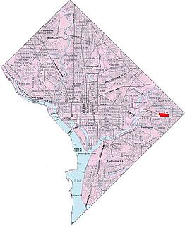
Benning is a residential neighborhood located in Ward 7 of Northeast Washington, D.C. It is bounded by East Capitol Street to the south, Minnesota Avenue to the west, and Benning Road on the north and east. It is served by the Benning Road station on the Blue Line of the Washington Metro.
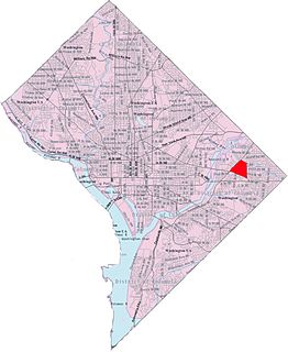
Benning Heights is a residential neighborhood located in northeast Washington, D.C. It is bounded by East Capitol Street to the south, Brooks Street NE to the north, 44th Street NE and Benning Road NE to the west, and Division Avenue NE to the east. It is served by the Benning Road Metro Rail station on the Blue Line and Silver Line of the Washington Metro.

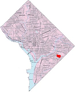
Benning Ridge is a residential neighborhood located in Southeast Washington, D.C. It is bounded by Fort Chaplin Park to the northwest, Southern Avenue to the south, Benning Road to the east, and Ridge Road SE to the west. Benning Ridge is an unusual neighborhood for its location east of the Anacostia River: although it is surrounded by working-class and low-income African American neighborhoods, Benning Ridge is rather affluent, with a diverse population of middle- and upper-middle-class white and black residents.

Fort Dupont is a residential neighborhood located in southeast Washington, D.C., east of the Anacostia River. It is bounded by East Capitol Street to the north, Fort Dupont Park to the south, Minnesota Avenue to the west, and Fort Chaplin Park to the east and northeast.
Buena Vista is a residential neighborhood in Southeast Washington, D.C., in the United States. Buena Vista is located in Ward 8. The neighborhood is dominated by detached single-family housing and multi-family apartment complexes.

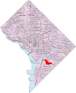
Navy Yard, also known as Near Southeast, is a neighborhood on the Anacostia River in Southeast Washington, D.C. Navy Yard is bounded by Interstate 695 to the north and east, South Capitol Street to the west, and the Anacostia River to the south. Approximately half of its area is occupied by the Washington Navy Yard, which gives the neighborhood its name. The neighborhood is located in D.C.'s Ward 6, currently represented by Charles Allen. It is served by the Navy Yard – Ballpark Metro station on the Green Line.

Civic Betterment is a small neighborhood located in Southeast Washington, D.C., on the border of Prince George's County, Maryland. It is triangular in area, bounded by G and Fitch Streets SE to the north, Benning Road SE to the southwest, and Southern Avenue to the southeast.
Central Northeast, also sometimes called Mahaning Heights, is a small neighborhood located in Northeast Washington, D.C. with Fort Mahan Park at its center. It is bounded by Nannie Helen Burroughs Avenue to the north, Benning Road to the south, the tracks of the Washington Metro and Minnesota Ave station to the west, and 44th Street NE to the east.

Kenilworth is a residential neighborhood in Northeast Washington, D.C., located on the eastern bank of the Anacostia River and just inside the D.C.-Maryland border. A large public housing complex, Kenilworth Courts, dominates the area. The neighborhood is famous for the Kenilworth Park and Aquatic Gardens, a national park whose centerpiece is a series of ponds carved out of Anacostia River marshland. Visitors come especially during June and July to see the beautiful blooming water lilies and lotus flowers. Kenilworth Park, which includes the Kenilworth-Parkside Recreation Center, also carries the neighborhood name, though most of the park's area is actually located adjacent to the modern neighborhoods of Parkside and Eastland Gardens.

River Terrace is an urban cul-de-sac neighborhood in Northeast Washington, D.C., on the eastern bank of the Anacostia River. River Terrace is Washington, DC's only planned unit development that has an unimpeded connection to and relationship with the Anacostia River.

Randle Highlands is a neighborhood in Southeast Washington, D.C., east of the Anacostia River.
Penn Branch is a neighborhood in Southeast Washington, D.C., east of the Anacostia River. It is bounded by Pennsylvania Avenue SE to the south; Pope Branch Park and Pope Creek to the north; Branch Avenue to the west; and Fort Davis Park to the east. ‘Penn Branch’, takes its name from its location at the intersection of two major thoroughfares, Pennsylvania and Branch Avenue.

