Downtown (Washington, D.C.)

Last updated

Downtown Historic District
Madame Tussauds, Washington, D.C. 2011 2.jpg
2008 map of Downtown area and emerging Center City areas.jpg
Pink area was designated in 2008 as "existing Downtown areas of Washington, D.C.; blue indicated then-emerging areas of Center City Washington.
LocationRoughly, 7th St. from Pennsylvania Avenue to Mt. Vernon Sq., and F St. between 11th and 7th Sts., NW, Washington, D.C.
Area50 acres (20 ha)
ArchitectMultiple
Architectural styleLate 19th And 20th Century Revivals, Late Victorian
NRHP reference No. 84003901 [1]
Added to NRHPSeptember 22, 2001

Downtown is the central business district of Washington, D.C., located in Northwest D.C. It is the third largest central business district in the United States. The "Traditional Downtown" has been defined as an area roughly between Union Station in the east and 16th Street NW in the west, and between the National Mall on the south and Massachusetts Avenue on the north, including Penn Quarter. However, nowadays, Downtown D.C. usually refers to a larger area, as the DC Office of Planning states:

Contents

…most residents, workers, and visitors think of Downtown in a broader sense — including areas as far north as Dupont Circle, as far west as Foggy Bottom, and as far east as Capitol Hill. Only about half of the central city workforce is located within the city’s traditional Downtown. [2]

ِِِA small portion of this area is known as the Downtown Historic District and was listed on the NRHP in 2001. [1]

Geography and subdistricts

Aerial view of Foggy Bottom, which the Washington D.C. Planning Department includes in its broader definition of Downtown Washington, D.C. Foggy Bottom - aerial view.jpg
Aerial view of Foggy Bottom, which the Washington D.C. Planning Department includes in its broader definition of Downtown Washington, D.C.

The Washington, D.C. government does not officially define neighborhoods or neighborhood boundaries, [3] so there are varying definitions of which areas constitute Downtown D.C. or the central business district of D.C.

In a 2008 map, the city's planning department showed as existing Downtown areas a broad swathe of everything between Georgetown on the west and Union Station on the east, with a northern boundary of and Massachusetts Avenue, and a southern boundary, roughly, of E Street, thus including the West End, Foggy Bottom, Golden Triangle, Traditional Downtown, Chinatown, Mount Vernon Square, and Downtown East. [4]

This diamond-shaped area stretches from Union Station in the east, south to the National Mall, northwest past the White House to Washington Circle in Foggy Bottom and northeast to DuPont Circle. It includes not only the Traditional Downtown and the Golden Triangle (which is the southern part of DuPont Circle neighborhood), but also West End and Foggy Bottom. [2]

Traditional Downtown

Ford's Theatre on 10th St. NW, part of the traditional Downtown Fords theatre 10th st.jpg
Ford's Theatre on 10th St. NW, part of the traditional Downtown

The Downtown BID boundaries roughly conform with the more traditional definitions of Downtown and those of the Downtown Urban Renewal Action Area [5] and are: [6]

The Downtown BID thus encompasses Penn Quarter, Chinatown, CityCenterDC, and the F Street shopping district.

Golden Triangle

Farragut Square Park, in the Golden Triangle Farragut square from southeast.jpg
Farragut Square Park, in the Golden Triangle

The Golden Triangle is an area defined by the Golden Triangle Business Improvement District (BID). It is part of a larger Downtown area according to The Washington Post and DC Department of Planning. The Golden Triangle boundaries are, very roughly: [7]

Character, attractions, and services

The Shakespeare Theatre Company has a theatre located in Penn Quarter. Harman Center for the Arts DC - Stierch.jpg
The Shakespeare Theatre Company has a theatre located in Penn Quarter.

By the 1990s and continuing into the 2010s, the core of the downtown district was almost exclusively commercial, and its primary commercial use was as office buildings. [8] The area also featured a number of attractions, including museums (such as the International Spy Museum, National Aquarium, National Archives, National Building Museum, National Museum of Women in the Arts, National Portrait Gallery, Newseum, and Smithsonian American Art Museum) and theaters (such as Ford's Theatre, National Theatre, Shakespeare Theatre, Warner Theatre, and Woolly Mammoth Theatre). [9] The Penn Quarter and Chinatown areas in particular are home to many bars and restaurants, [10] and the observation deck in the tower of the Old Post Office Pavilion is known for its views of the city. [11] 7th Street NW between H and F Streets NW—a short commercial strip known as "Gallery Place"—has become a major hub of bars, restaurants, theaters, and upscale retail shops. [12]

However, even as late as 2010, most of the core area tended to be empty of pedestrian foot traffic at night, except for streets immediately around theaters and restaurants. [8] [13] Downtown D.C. has been adding residents, however, and pedestrian traffic at night is increasing. In 1990, the area had about 4,000 residents, but this had increased to 8,449 by 2010. [14] Such increases appear small, but are more significant than they seem because the city's height restrictions limit population density. [15] The completion of the $950 million CityCenterDC project in late 2013 is estimated to add another 1,000 or more residents. [14] One exception to the low nighttime foot traffic is Gallery Place, where large crowds gather day and night, especially after sporting events at the Capital One Arena. [12] Crime and street brawls increased in the area and its adjacent Gallery Place Metro station between 2008 and 2010, primarily due to the large groups of teenagers from across the metropolitan area gathering there. [12]

Notable downtown restaurants include Fogo de Chão, Loeb's NY Deli, Old Ebbitt Grill, and Wok 'n' Roll (located in the Mary E. Surratt Boarding House). Chinatown and Gallery Place are noted for being geographically small but also having a very large number of restaurants. [10]

Capital One Arena (originally MCI Center, later Verizon Center), a major basketball, hockey, and events venue, opened on Mount Vernon Square in 1997. [16] It proved to be a major attraction, drawing more than 20 million visitors in its first decade of operation. [16]

Union Station anchors downtown on the east and besides serving as a hub for Amtrak, VRE and MARC suburban rail, Metro rail and buses, was also an important shopping and dining destination from 1988 [17] until COVID-19 in 2020 foreced most tenants to close. As of 2022, authorities are considering plans for renovation and new construction over the railyards behind the station connecting it to the burgeoning NoMa neighborhood. [18]

Cityscape

The Willard Hotel was designed in the Beaux-Arts style. Willard Hotel from Pershing Park4.jpg
The Willard Hotel was designed in the Beaux-Arts style.

The majority of downtown Washington is composed of office buildings of varying architectural styles. The oldest tend to be of the Federal school, as are the White House, the Treasury Building, Blair House, and the rowhouses that line Lafayette Square. Others run the gamut from Neoclassical (such as the buildings at Federal Triangle) [19] to Second Empire-style (the Eisenhower Executive Office Building) [20] to postmodern (One Farragut Square South [21] and Franklin Tower at 1401 I Street NW). [22] The historic Willard Hotel was built in the Beaux-Arts style. [23]

Height restriction

This 2007 aerial view of Downtown D.C. shows the low height of buildings due to the city's height restrictions. Aerial view of Willard Hotel, White House, and downtown Washington, D.C LCCN2010630890.tif
This 2007 aerial view of Downtown D.C. shows the low height of buildings due to the city's height restrictions.
The intersection of K and 17th streets in Downtown Washington. Washington DC K at 17th street winter.JPG
The intersection of K and 17th streets in Downtown Washington.

Unlike other large cities in the U.S., Washington's downtown has a low skyline. With the advent of the skyscraper and the construction of the Cairo Hotel, residents were concerned that the city's European feel might be dwarfed by high-rise buildings. Congress therefore passed the Heights of Buildings Act in 1899, limiting any new building in Washington to a height of 110 feet (34 m). The act was amended in 1910 to allow buildings 20 feet (6.1 m) higher than the width of the adjacent street. [24]

As of 2006, the tallest building in downtown Washington—excluding the Washington Monument, U.S. Capitol, Washington National Cathedral, and the Basilica of the National Shrine of the Immaculate Conception, all of which are outside of the downtown district—is the Old Post Office Pavilion, whose 315-foot (96 m) tall clock tower looms far above other nearby structures. [25] The tallest commercial building is One Franklin Square, at 210 feet (64 m). [26]

Parks and public squares

The Hamilton Hotel located off Franklin Square in Downtown Washington. 1001 14th Street NW - Washington DC - Holiday Inn Hamilton Crowne Plaza Hotel.JPG
The Hamilton Hotel located off Franklin Square in Downtown Washington.

A number of public urban parks exist in the downtown area. Among the more prominent are: Farragut Square, Franklin Square, Judiciary Square, Lafayette Square (the portion of President's Park north of the White House), McPherson Square, Mount Vernon Square, the National World War I Memorial (formerly Pershing Park), Scott Circle, Thomas Circle, and Washington Circle.

The largest paved square in the city, Freedom Plaza, is located on Pennsylvania Avenue NW between 13th and 14th Streets NW. The city pedestrianized a two-block-long stretch of 16th Street NW closest to the White House as Black Lives Matter Plaza and pedestrianized it in 2020, [27] [28] during the series of George Floyd protests taking place in the city. [29]

Governance

Two business improvement districts cover the downtown D.C. area. The Downtown DC Business Improvement District (Downtown DC BID) is bounded by 16th Street NW, Massachusetts Avenue NW, and Constitution Avenue NW, and is funded by a voluntary tax provided by 825 businesses in the area. [30] The Golden Triangle Business Improvement District (Golden Triangle BID) is bounded by 16th Street NW, Massachusetts Avenue NW, 21st Street NW, and Pennsylvania Avenue NW. [30] Both BIDs work to enhance the diversity of business in their respective jurisdictions as well as the quality of life by providing directions for tourists, improving street and sidewalk cleanliness, and advising police about potential or existing problems.

Various federal (Federal Protective Service, Federal Bureau of Investigation, Secret Service, United States Mint Police, United States Park Police, etc.), city (Metropolitan Police Department of the District of Columbia, District of Columbia Housing Authority Office of Public Safety), and regional (Metro Transit Police Department) law enforcement agencies have concurrent, overlapping jurisdiction in downtown D.C. [31] Both BIDs in the area also provide semi-uniformed unsworn police forces, which help to maintain order and provide street intelligence by communicating via cell phone with the Metropolitan Police Department and Metro Transit Police. [32] D.C. Housing Authority Police do not have jurisdiction outside public housing, but do patrol Gallery Place to pick up and provide intelligence on the activities of youth congregating there who live in city-provided housing units. [12]

Education

Higher education

The George Washington University, Foggy Bottom Campus.

See also

Related Research Articles

<span class="mw-page-title-main">Foggy Bottom</span> Neighborhood in Washington, D.C., United States

Foggy Bottom is a neighborhood of Washington, D.C., United States, located in the city's northwest quadrant. Stretching west of the White House towards the Potomac River, the neighborhood is home to numerous federal agencies and international institutions, while the core of the neighborhood is occupied by George Washington University.

<span class="mw-page-title-main">Foggy Bottom–GWU station</span> Washington Metro station

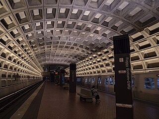
Foggy Bottom–GWU station is an Washington Metro station in the Foggy Bottom neighborhood of Washington, D.C., United States. The island-platformed station was opened on July 1, 1977, and is operated by the Washington Metropolitan Area Transit Authority (WMATA). Providing service for the Blue, Orange, and Silver Lines, the station is located on I Street on the George Washington University (GWU) campus. It is the last westbound station in the District of Columbia on these lines before they dive under the Potomac River to Virginia.

<span class="mw-page-title-main">Farragut Square</span> Urban park in Washington, D.C., U.S.

Farragut Square is a city square in Washington, D.C.'s Ward 2. It is bordered by K Street NW to the north, I Street NW to the south, on the east and west by segments of 17th Street NW, and interrupts Connecticut Avenue NW. It is the sister park of McPherson Square two blocks east. It is serviced by two stops on the Washington Metro rail system: Farragut North on the Red Line and Farragut West on the Blue, Orange, and Silver Lines.

<span class="mw-page-title-main">Northwest (Washington, D.C.)</span> Quadrant in the United States

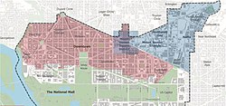
Northwest is the northwestern quadrant of Washington, D.C., the capital of the United States, and is located north of the National Mall and west of North Capitol Street. It is the largest of the four quadrants of the city, and it includes the central business district, the Federal Triangle, and the museums along the northern side of the National Mall, as well as many of the District's historic neighborhoods.

<span class="mw-page-title-main">West End (Washington, D.C.)</span> Place in the United States

The West End is a neighborhood in the Northwest quadrant of Washington, D.C., bounded by K Street NW to the south, Rock Creek Park to the west and north, and New Hampshire Avenue NW and 23rd Street NW to the east. The West End is so named because it was the westernmost part of the original L'Enfant Plan for the city of Washington, before the annexation of Georgetown. It is home to the embassies of Spain and Qatar as well as the Delegation of the European Union to the United States. The George Washington University and George Washington University Hospital are on the edge of the West End, at Washington Circle.

<span class="mw-page-title-main">14th Street (Washington, D.C.)</span> Street in northwest and southwest quadrants of Washington, D.C., US

14th Street NW/SW is a street in Northwest and Southwest quadrants of Washington, D.C., located 1.25 miles (2.01 km) west of the U.S. Capitol. It runs from the 14th Street Bridge north to Eastern Avenue.

<span class="mw-page-title-main">Neighborhoods in Washington, D.C.</span>

Neighborhoods in Washington, D.C., United States are distinguished by their history, culture, architecture, demographics, and geography. The names of 131 neighborhoods are unofficially defined by the D.C. Office of Planning. Neighborhoods can be defined by the boundaries of wards, historic districts, Advisory Neighborhood Commissions, civic associations, and business improvement districts (BIDs); these boundaries will overlap. The eight wards each elect a member to the Council of the District of Columbia and are redistricted every ten years.

<span class="mw-page-title-main">Washington Circle</span> Traffic circle in Washington, D.C.

Washington Circle is a traffic circle in the northwest quadrant of Washington, D.C., United States. It is located on the border of the Foggy Bottom and West End neighborhoods, which is a part of the Ward 2 section in Washington. It is the intersection of 23rd Street, K Street, New Hampshire Avenue, and Pennsylvania Avenue, N.W. It borders many buildings of the George Washington University campus. The through lanes of K Street travel underneath the circle via a tunnel, while the service lanes intersect the circle.

<span class="mw-page-title-main">Mount Vernon Square</span> United States historic place

Mount Vernon Square is a city square and neighborhood in the Northwest quadrant of Washington, D.C. The square is located where the following streets would otherwise intersect: Massachusetts Avenue NW, New York Avenue NW, K Street NW, and 8th Street NW.

<span class="mw-page-title-main">Massachusetts Avenue (Washington, D.C.)</span> Major road in Washington, D.C., U.S.

Massachusetts Avenue is a major diagonal transverse road in Washington, D.C., and the Massachusetts Avenue Historic District is a historic district that includes part of it.

<span class="mw-page-title-main">Connecticut Avenue</span> Thoroughfare in Washington, D.C., and Maryland

Connecticut Avenue is a major thoroughfare in the Northwest quadrant of Washington, D.C., and suburban Montgomery County, Maryland. It is one of the diagonal avenues radiating from the White House, and the segment south of Florida Avenue was one of the original streets in Pierre (Peter) Charles L'Enfant's plan for Washington. A five-mile segment north of Rock Creek was built in the 1890s by a real-estate developer.

<span class="mw-page-title-main">16th Street NW</span> Road in Washington, D.C.

16th Street Northwest, briefly known as the Avenue of the Presidents, is a prominent north-south boulevard in Washington, D.C., located in Northwest D.C. The street was laid out as part of the 1791 L'Enfant Plan, which served as the original blueprint for the city. The street begins just north of the White House, across from Lafayette Square in the President's Park, and continues north along the Washington meridian until Blair Circle.

<span class="mw-page-title-main">Rhode Island Avenue</span>

Rhode Island Avenue is a diagonal avenue in the Northwest and Northeast quadrants of Washington, D.C., and the capital's inner suburbs in Prince George's County, Maryland. Paralleling New York Avenue, Rhode Island Avenue was one of the original streets in Pierre L'Enfant's plan for the capital. It became a major commuter route, carrying U.S. Route 1 traffic into the city from Prince George's County.

<span class="mw-page-title-main">Quadrants of Washington, D.C.</span> Geographical quadrant

Washington, D.C., is administratively divided into four geographical quadrants of unequal size, each delineated by their ordinal directions from the medallion located in the Crypt under the Rotunda of the Capitol. Street and number addressing, centered on the Capitol, radiates out into each of the quadrants, producing a number of intersections of identically named cross-streets in each quadrant. Originally, the District of Columbia was a near-perfect square but contained more than one settlement; the Capitol was to be the center of the City of Washington. Thus, the Capitol was never located at the geographic center of the whole territory, which was eventually north of the Potomac River, consolidated into one city. As a result, the quadrants are of greatly varying size. Northwest is quite large, encompassing over a third of the city's geographical area, while Southwest is little more than a few neighborhoods, large parks, and a military base.

The campus of the George Washington University (GW), originated on College Hill, a site bounded by 14th Street, Columbia Road, 15th Street and Florida Avenue, NW in the Columbia Heights neighborhood of Washington, D.C. After relocating to the downtown financial district in the 1880s and then to Foggy Bottom in 1912, GW now has three campuses. Foggy Bottom is the location of the university's main campus in Washington, D.C. Also in Washington's Foxhall neighborhood is the Mount Vernon Campus, formerly the Mount Vernon College for Women. Additionally, the George Washington University Virginia Campus is located in Ashburn, VA.

<span class="mw-page-title-main">Golden Triangle (Washington, D.C.)</span> US business improvement district

The Golden Triangle is a neighborhood and business improvement district (BID) in Washington, D.C. Covering 43 blocks, it encompasses the western part of Washington's central business district, running from the front yard of the White House's north side to Dupont Circle and from 16th Street NW to 21st Street NW and including sections of K Street and Connecticut Avenue. The commercial neighborhood is home to more than 3,000 organizations, 200 restaurants, 300 shops and retailers, 7 hotels, and 6 national parks.

<span class="mw-page-title-main">Mount Vernon Triangle Historic District</span> Historic district in Washington, D.C., United States

The Mount Vernon Triangle Historic District is a historic district in the Mount Vernon Triangle neighborhood of Washington, D.C., consisting of 22 contributing residential, commercial, and industrial buildings, and one known archaeological site. The area was once a working class neighborhood for mostly German immigrants and home to semi-industrial enterprises such as a dairy and an automobile repair shop. The Northern Liberty Market that once stood on the corner of 5th Street and K Street NW played a large role in spurring development in the surrounding area as did the streetcars on Massachusetts Avenue and New York Avenue.

<span class="mw-page-title-main">Rawlins Park</span> Park in Washington, D.C., U.S.

Rawlins Park is a rectangular public park in the Foggy Bottom neighborhood of Washington, D.C., two blocks west of the White House grounds and two blocks north of the National Mall. The boundaries of the park are 18th Street NW to the east, E Street NW to the south and north, and 19th Street NW to the west. The park was an undeveloped open space for many years, until plans were made to install the statue of John Aaron Rawlins in 1874. Various improvements were made, but the area surrounding the park remained mostly undeveloped. This changed in the 1890s when the area was cleared of marshes, and houses were built on the park's southern border.

<span class="mw-page-title-main">Mount Vernon Triangle</span> Place in the United States

Mount Vernon Triangle is a neighborhood and community improvement district in the northwest quadrant of Washington, D.C. The neighborhood is located adjacent to Mount Vernon Square. Originally a working-class neighborhood established in the 19th century, present-day Mount Vernon Triangle experienced a decline in the mid-20th century as it transitioned from residential to commercial and industrial use.

<span class="mw-page-title-main">George S. Cooper</span> American architect and builder

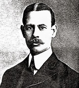
George S. Cooper was an American architect and builder from Washington, D.C. During his 40-year career, he was responsible for designing around 850 properties, including homes, commercial buildings and apartment buildings, several of which are listed on the National Register of Historic Places (NRHP). The 1903 book History of the City of Washington states: "It may be thought that Mr. Cooper's forte lies in the designing of apartment houses, since the handsomest in the city are a result of his genius..." and "No young man has played a more important part in the active growth and great development of Greater Washington than George S. Cooper..."

References

  1. 1 2 "National Register Information System". National Register of Historic Places . National Park Service. July 9, 2010.
  2. 1 2 The Comprehensive Plan for the National Capital: Chapter 16, Central Washington Area Element (PDF). District of Columbia Department of Planning. p. 16-1. Archived (PDF) from the original on October 29, 2020. Retrieved November 7, 2020.
  3. "Neighborhood Clusters". opendata.dc.gov. Archived from the original on July 3, 2020. Retrieved March 11, 2023.
  4. "Map p.2-3 in "Center City Action Agenda 2008", District of Columbia Department of Planning" (PDF). Archived (PDF) from the original on November 15, 2020. Retrieved November 9, 2020.
  5. "Map of Downtown Urban Renewal Action Area, National Capital Planning Commission site, accessed July 2, 2020". Archived from the original on October 18, 2020. Retrieved March 11, 2023.
  6. "DowntownDC | BID-Map". Archived from the original on July 4, 2020. Retrieved March 11, 2023.
  7. "Golden Triangle | The Heart of DC's Business District". Golden Triangle. Archived from the original on March 11, 2023. Retrieved March 11, 2023.
  8. 1 2 Bednar, p. 243.
  9. Jabado, p. 57-60.
  10. 1 2 Jabado, p. 57.
  11. Jabado, p. 60.
  12. 1 2 3 4 Davenport, Christian; du Lac, J. Freedom; Rosenwald, Michael S.; Schulte, Brigid; Shapira, Ian; Shin, Annys; and Sieff, Kevin. "Fights, Teens Among Challenges as D.C.'s Gallery Place Entertainment Area Matures." The Washington Post. August 13, 2010.
  13. Jabado, p. 59.
  14. 1 2 O'Connell, Jonathan. "Mixed-Use Project Is Coda for Downtown D.C. Revival." The Washington Post. April 5, 2011.
  15. Pristin, Terry. "Washington Makes Downtown a Destination Again." New York Times. September 1, 2004.
  16. 1 2 McGregor, p. 285.
  17. "How Union Station was Saved in the 1980s". November 12, 2014. Archived from the original on January 26, 2023. Retrieved January 26, 2023.
  18. "Washington Union Station's 2nd Century Plan | Amtrak Northeast Corridor". Archived from the original on January 26, 2023. Retrieved January 26, 2023.
  19. "Mellon Indorses Building Program of Classic Style." The Washington Post. December 11, 1927.
  20. Smith, et al., p. 85.
  21. "12-Story Building for District." The Washington Post. November 12, 1960.
  22. Hilzenrath, David S. "Building In Defiance of the Bust." The Washington Post. December 31, 1990; "Franklin Tower." Washington Times. January 17, 2000.
  23. Denby, Grand Hotels: Reality and Illusion, 2004, p. 221–222.
  24. "Grunwald, Michael. "D.C.'s Fear of Heights." The Washington Post. July 2, 2006". Archived from the original on March 3, 2016. Retrieved September 20, 2017.
  25. Minetor and Minetor, p. 38.
  26. "One Franklin Square." Emporis.com. 2011. Accessed 2011-09-02.
  27. Asmelash, Leah (June 6, 2020). "Washington's New Black Lives Matter Street Mural Is Captured on Satellite". CNN. Archived from the original on July 7, 2022. Retrieved June 7, 2020.
  28. Johnson, Martin (June 6, 2020). "Bowser Addresses Record Crowd at Black Lives Matter Plaza". The Hill . Archived from the original on April 16, 2022. Retrieved June 7, 2020.
  29. Johnson, Ted (June 6, 2020). "DC Mayor Chides Donald Trump at Largest Protest Since Death of George Floyd: 'We Pushed the Army Away from Our City'". Deadline . Archived from the original on June 7, 2020. Retrieved June 7, 2020.
  30. 1 2 Ford, p. 69.
  31. Dempsey and Forst, p. 45.
  32. Manning, p. 113.

Bibliography

Commons-logo.svg Media related to Downtown Washington, D.C. at Wikimedia Commons

38°54′9″N77°1′58.3″W / 38.90250°N 77.032861°W / 38.90250; -77.032861