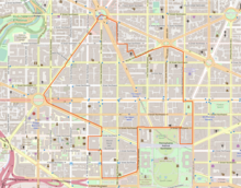
Dupont Circle is a historic roundabout park and neighborhood of Washington, D.C., located in Northwest D.C. The Dupont Circle neighborhood is bounded approximately by 16th Street NW to the east, 22nd Street NW to the west, M Street NW to the south, and Florida Avenue NW to the north. Much of the neighborhood is listed on the National Register of Historic Places. However, the local government Advisory Neighborhood Commission and the Dupont Circle Historic District have slightly different boundaries.

Farragut North station is an underground Washington Metro station in Washington, D.C., on the Red Line.

Dupont Circle station is an underground rapid transit station on the Red Line of the Washington Metro in Washington, D.C. Located below the traffic circle, it is one of the busiest stations in the Metro system, with an average of 16,948 entries each weekday. The station parallels Connecticut Avenue NW between the southern edge of the circle to the south and Q Street NW to the north.

Adams Morgan is a neighborhood in Washington, D.C., located in Northwest D.C., centered on the intersection of 18th Street NW and Columbia Road. The Washington Hilton and Madam's Organ Blues Bar are in Adams Morgan. Residential buildings include Euclid Apartments, Fuller House, Park Tower, Meridian Mansions, and the Pink Palace. Embassies in the neighborhood include the embassies of Lithuania, Poland, the Central African Republic, Gabon and Cuba. Carry the Rainbow on Your Shoulders, The Servant Christ, and The Mama Ayesha's Restaurant Presidential Mural are examples of public artwork in Adams Morgan.

Mount Vernon Square station is a Washington Metro station in Washington, D.C., on the Green and Yellow Lines. It is the northeastern terminus of the Yellow Line.

Farragut Square is a city square in Washington, D.C.'s Ward 2. It is bordered by K Street NW to the north, I Street NW to the south, on the east and west by segments of 17th Street NW, and interrupts Connecticut Avenue NW. It is the sister park of McPherson Square two blocks east. It is serviced by two stops on the Washington Metro rail system: Farragut North on the Red Line and Farragut West on the Blue, Orange, and Silver Lines.

Northwest is the northwestern quadrant of Washington, D.C., the capital of the United States, and is located north of the National Mall and west of North Capitol Street. It is the largest of the four quadrants of the city, and it includes the central business district, the Federal Triangle, and the museums along the northern side of the National Mall, as well as many of the District's historic neighborhoods.

14th Street NW/SW is a street in Northwest and Southwest quadrants of Washington, D.C., located 1.25 miles (2.01 km) west of the U.S. Capitol. It runs from the 14th Street Bridge north to Eastern Avenue.
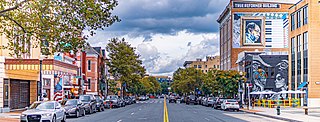
The U Street Corridor, sometimes called Cardozo/Shaw or Cardozo, is a commercial and residential district in Northwest Washington, D.C., most of which also constitutes the Greater U Street Historic District. It is centered along a nine-block stretch of U Street from 9th to 18th Streets, which from the 1920s until the 1960s was the city's black entertainment hub, called "Black Broadway" and "the heart of black culture in Washington, D.C.". After a period of decline following the 1968 riots, the economy picked up with the 1991 opening of the U Street Metro station. Subsequent gentrification diversified the population, which is 67% non-Hispanic White and 18% African American. Since 2013, thousands of residents have moved into new luxury apartment buildings. U Street is now promoted as a "happening" neighborhood for upscale, "hip", and "eclectic" dining and shopping, its live music and nightlife, as well as one of the most significant African American heritage districts in the country.

Massachusetts Avenue is a major diagonal transverse road in Washington, D.C., and the Massachusetts Avenue Historic District is a historic district that includes part of it.

Connecticut Avenue is a major thoroughfare in the Northwest quadrant of Washington, D.C., and suburban Montgomery County, Maryland. It is one of the diagonal avenues radiating from the White House, and the segment south of Florida Avenue was one of the original streets in Pierre (Peter) Charles L'Enfant's plan for Washington. A five-mile segment north of Rock Creek was built in the 1890s by a real-estate developer.

Florida Avenue is a major street in Washington, D.C. It was originally named Boundary Street, because it formed the northern boundary of the Federal City under the 1791 L'Enfant Plan. With the growth of the city beyond its original borders, Boundary Street was renamed Florida Avenue in 1890.

"NoMa" is a moniker for the area north of Massachusetts Avenue located north and east of Union Station in Washington, D.C. NoMa includes the neighborhoods of Sursum Corda, Eckington, and Near Northeast and includes a section historically known as Swampoodle.

Woodley Park is a neighborhood in Northwest, Washington, DC. It is bounded on the north by Woodley Road and Klingle Road, on the east by the National Zoo and Rock Creek Park, on the south by Calvert Street, on the southwest by Cleveland Avenue, and on the west by 34th Street.

Downtown is the central business district of Washington, D.C., located in Northwest D.C. It is the fourth largest central business district in the United States. The "Traditional Downtown" has been defined as an area roughly between Union Station in the east and 16th Street NW in the west, and between the National Mall on the south and Massachusetts Avenue on the north, including Penn Quarter. However, nowadays, Downtown D.C. usually refers to a larger area, as the DC Office of Planning states:
…most residents, workers, and visitors think of Downtown in a broader sense — including areas as far north as Dupont Circle, as far west as Foggy Bottom, and as far east as Capitol Hill. Only about half of the central city workforce is located within the city’s traditional Downtown.
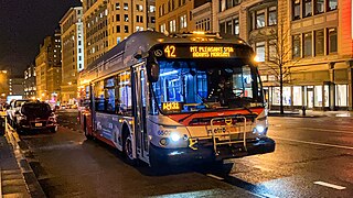
The Mount Pleasant Line, designated Routes 42 and 43, is a daily bus route in Washington, D.C., It was a streetcar line until the 1960s.
Columbia Road is a street in Washington, D.C., that forks from Connecticut Avenue north of Dupont Circle, and branches north and east through 16th Street to the McMillan Reservoir. Along its route, it marks the southern border of the Kalorama Triangle neighborhood, the principal east/west passage through the Adams Morgan neighborhood, and is one of the primary thoroughfares in the Columbia Heights neighborhood. In Adams Morgan, it is bordered by a great deal of street-level retail, constituting the main commercial area within Adams Morgan.

The Connecticut Avenue Line, designated Route L2, is a daily bus route in Northwest Washington, D.C., United States. The L2 operates seven days a week.
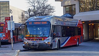
The Massachusetts Avenue Line, designated Route N2, N4, N6, is a daily bus route operated by the Washington Metropolitan Area Transit Authority between Friendship Heights station of the Red Line of the Washington Metro and Farragut Square in Downtown Washington DC. The line operates every 27 minutes during the weekdays and 40 minutes on weekends. Trips take roughly 45 minutes to complete.

The Demonet Building is composed of a historic townhouse and adjoining office building on the southeast corner of Connecticut Avenue and M Street N.W. in Washington, D.C. Constructed in 1880, the townhouse is the last Victorian residence on Connecticut Avenue between Dupont Circle and Farragut Square that has not been significantly altered. It features an octagonal tower topped by a dome with cartouche windows. Following a multi-year legal battle to demolish the townhouse, which had been added to the District of Columbia Inventory of Historic Sites in 1979, the Demonet Building and adjoining lot were sold for what was then a record price for downtown real estate. The adjoining office building, designed by Skidmore, Owings & Merrill, was completed in 1984.