Kingman Park

Last updated
Kingman Park
Coordinates: 38°53′41″N76°58′46″W / 38.89472°N 76.97944°W / 38.89472; -76.97944
Country United States
District Washington, D.C.
WardWard 7
Established1927
Founded byCharles Sager
Government
  Councilmember Vincent C. Gray
Website http://www.kingmanpark.com
Kingman Park Historic District
Kingman Park DC row houses 08.jpg
Kingman Park row houses
USA District of Columbia location map.svg
Red pog.svg
Usa edcp location map.svg
Red pog.svg
LocationBetween Rosedale & D St., Maryland Ave. NE, 19th St. & Oklahoma Ave. NE; also 900-2000 blks. of C, D and E Sts. NE; 300 and 400 blks. of 19th and 20th Sts. NE.
NRHP reference No. 100002960
Added to NRHPDecember 17, 2018

Kingman Park is a residential neighborhood in the Northeast quadrant of Washington, D.C., the United States capital city. Kingman Park's boundaries are 15th Street NE to the west; C Street SE to the south; Benning Road to the north; and Anacostia Park to the east. [1] The neighborhood is composed primarily of two-story brick rowhouses [2] (most of which were built when the neighborhood was founded in 1928). [3] Kingman Park is named after Brigadier General Dan Christie Kingman, the former head of the United States Army Corps of Engineers (for whom nearby Kingman Island and Kingman Lake are also named). [4] [5]

Contents

Early history

Before the 1920s, Kingman Park was a largely uninhabited, wooded area located near the D.C. city dump. [2] The area was originally on the shores of the Anacostia River. Between 1860 and the late 1880s, large mudflats ("the Anacostia flats") formed on both banks of the Anacostia River due to deforestation and the heavy erosion it caused. [6] [7] At this time, the city allowed its sewage to pour untreated into the Anacostia. Marsh grass began growing in the flats, trapping the sewage and leading public health experts to conclude that the flats were unsanitary. [6] Health officials also feared that the flats were a prime breeding ground of malaria- and yellow fever-carrying mosquitoes. [6] By 1876, a large mudflat had formed just south of where Benning Bridge is today, and another, 740 feet (230 m) wide, had developed just south of the former flat. [8] By 1883, a stream named "Succabel's Gut" traversed the upper flat and another dubbed "Turtle Gut" the lower, and both flats hosted substantial populations of American lotus, lily pads, and wild rice. [7] In 1898, officials with the United States Army Corps of Engineers and the District of Columbia convinced the United States Congress that the Anacostia River should be dredged to create a more commercially viable channel that would enhance the local economy as well as provide land where factories or warehouses might be built. [4] [6] [9] The material dredged from the river would be used to build up the flats and turn them into dry land, eliminating the public health dangers they caused. [6] In 1901, the McMillan Commission (a body established by the United States Senate to advise the Congress and District of Columbia on ways to improve the parks, monuments, memorials, and infrastructure of the city as well as plan for urban renewal, economic growth, and expansion of the federal government) concluded that commercial land was not needed and proposed turning the reclaimed flats into parkland. [10] [11] The D.C. government agreed in 1905, [12] the United States Commission of Fine Arts (a federal advisory agency with review authority over the design and aesthetics of projects within Washington, D.C.) and the Army Corps of Engineers concurred in 1914, and the National Capital Park and Planning Commission signed on (belatedly) to the park plan in 1928. [10] Most of the reclaimed mudflats were subsequently declared to be parkland and named Anacostia Water Park (now Anacostia Park) in 1919. [10] This left the Kingman Park neighborhood cut off from the Anacostia River.

In 1805, local landowner Benjamin Stoddert built a wooden bridge over the Anacostia River at the present site of Benning Bridge. [13] [14] The bridge was sold to Thomas Ewell, who in the 1820s sold it to William Benning. [15] Thereafter the structure was known as Benning's Bridge (or Benning Bridge). The wooden bridge was rebuilt several times after 1805. This included construction of a steel bridge in 1892, [16] and the current beam-concrete pier bridge in 1934. [17]

Building the neighborhood

Aerial view of the Kingman Park neighborhood (outlined in red). The D.C. Armory and Robert F. Kennedy Stadium are center-left. The Whitney Young Memorial Bridge crosses the Anacostia River, center-bottom. Kingman Island (the long island), Heritage Island (the smaller island between Kingman Island and the far shore), and Kingman Lake (the water between Kingman Island and the far shore) can also be seen. Kingman Park - 1991 - outlined in red.jpg
Aerial view of the Kingman Park neighborhood (outlined in red). The D.C. Armory and Robert F. Kennedy Stadium are center-left. The Whitney Young Memorial Bridge crosses the Anacostia River, center-bottom. Kingman Island (the long island), Heritage Island (the smaller island between Kingman Island and the far shore), and Kingman Lake (the water between Kingman Island and the far shore) can also be seen.

Noted D.C. real estate developer Charles Sager began constructing homes on the vacant land that is now Kingman Park in 1927. The first 40 homes in the area, built on 24th Street NE, were sold in July 1928. [2] [3] Sager found that white homebuyers were not interested in living in the area, so he focused on selling homes to African Americans. [2] Thus, Kingman Park became the first D.C. neighborhood of single-family houses to be developed specifically for Black people. [18] By 1931, there were 230 homes in the area. [19] Development included 22nd through 25 Streets NE, between Benning Road and E Street SE. [19]

A major boost to development in the area came with the construction of Charles E. Young Elementary School and Hugh M. Browne Junior High School. In May 1930, the District of Columbia Public Schools decided to construct one junior high, and one senior high, and four elementary schools in the city, including a "platoon school" for black children in northeast D.C. near Benning Road. [20] [21] Originally scheduled to be finished in November 1931, the need for the new school was so great that the school board pushed up the construction completion date by two months in November 1930. [22] [23] [24] The new school was named for United States Army Colonel Charles E. Young, who was only the third black man to graduate from West Point, the first black U.S. national park superintendent, the first black man to achieve the rank of colonel in the U.S. Army, and the highest-ranking black officer in the Army at the time of his death in 1922. [25] Young Elementary School opened on October 1, 1931, (delayed a month due to construction backlogs), and graduated its first class in January 1932. [24] [26] [27] Efforts to open a junior high school for African American students in the Kingman Park area began around 1920, [28] but it was not until 1930 that the D.C. public school system actually built one. [20] Constructed adjacent to Young Elementary School, the new junior high was named for Hugh M. Browne, a Howard University professor and prominent educator. [28] Browne Junior High School opened in May 1932, and was the first junior high school for black students in Northeast D.C. [28]

The two new schools significantly boosted interest from homebuyers and development in the Kingman Park neighborhood. [23] Sager announced plans in February 1931 to build another 350 homes in the neighborhood, more than doubling its existing size. [19] The city also announced plans to build a new high school (in time, this became Spingarn High School) next to the Young and Browne schools. [19] [23] Additional houses were built in the late 1930s as sales took off. [29]

Most of the area's first residents were middle class African American families whose head of household worked for the federal government. [29] [30] Most of the African Americans who moved to the neighborhood in the 1940s and 1950s were Black people leaving the Deep South during the Great Migration. [1] The construction of Robert F. Kennedy Stadium in 1961 proved problematic for the neighborhood. The stadium lies directly east of Kingman Park, and soon after it opened residents began complaining about the immense amounts of traffic that flooded their streets, attendees at stadium events illegally parking on city streets, and excessive noise and trash. [31]

Despite this problem with RFK Stadium, the Kingman Park neighborhood is notably stable, with many families having owned the same home for several generations. [18] In the late 1970s and early 1980s, the neighborhood suffered a downturn as younger people grew up and left the area and homeowners (the majority of whom were now senior citizens) found themselves without access to public transportation or public services (such as grocery stores and pharmacies). [1] In 1991, the neighborhood had a population of about 10,000 residents. [32]

Kingman Park is currently part of both Ward 6 and Ward 7. Prior to 2001, all of Kingman Park had been part of Ward 6. But with neighborhoods east of the Anacostia River losing population while areas west of it gained voters, the D.C. City Council was forced to redraw each ward's boundaries in order to maintain equal populations. In June 2001, the D.C. City Council adopted and Mayor Anthony A. Williams signed the "Ward Redistricting Act," which transferred 1,840 residents of Kingman Park from Ward 6 to Ward 7. Many Kingman Park residents were very vocal about the change (which extended Ward 7 west of the Anacostia River for the first time). [33] But these protests were not successful, and the Kingman Park voters were added to Ward 7. [34] The Kingman Park Civic Association sued, claiming the city's action violated the federal Voting Rights Act. The Kingman Park voters lost their suit when the United States Court of Appeals for the District of Columbia Circuit held in 2003 that the District's actions did not violate federal law. [35] Kingman Park residents filed a second lawsuit in District of Columbia (e.g., state) court, claiming that the city's actions violated the "District of Columbia Election Act." But the District of Columbia Court of Appeals ruled against them in this second suit in 2007. [36] In 2015 all Kingman Park residents were granted Ward 6 vehicle registration stickers and parking privileges.

Civic action

In the early 1970s, the Washington Metro proposed allowing the planned Orange/Blue Line to come above-ground after it left the proposed Stadium–Armory Station. In addition to the Stadium-Armory stop south of RFK Stadium, Metro also proposed an "Oklahoma Avenue Station" with a large parking lot north of RFK on Oklahoma Avenue NE. Residents on Oklahoma Avenue NE and members of the Kingman Park Civic Association bitterly opposed the parking lot, fearing heavy traffic and streets clogged with non-residents parking illegally in front of their homes. The Civic Association demanded that the station be placed underground, a request Metro opposed because it would cost $40 million. [37] Residents also demanded that Metro cancel the parking lot. Residents began heavily lobbying District and federal officials against the parking lot, and in 1977, Metro finally canceled all plans for an Oklahoma Avenue Station—marking the only time citizen groups in the District of Columbia were able to get an entire station scrapped. [37] [38]

In 1975, federal, regional, and city transportation planners proposed an extension to I-695/Southeast Freeway to be called the "Barney Circle Freeway" to help alleviate the problems created by the failure to complete the Inner Loop. [39] The freeway would extend I-695 past its existing terminus at the Barney traffic circle, and travel along the western bank of the Anacostia River (through Anacostia Park) to East Capitol Street and Robert F. Kennedy Memorial Stadium. [39] [40] [41] A new bridge over the Anacostia River at Kingman Island would provide vehicles easy access to the Anacostia Freeway. [39] [40] [41] But protests from Kingman Park and other residents of Capitol Hill forced the District of Columbia to reduce the number of lanes on the Barney Circle Freeway to two from four. [42] The protests and legal and regulatory challenges to the proposed freeway did not end, however, and by 1992 the freeway's cost had ballooned to $160 million and it remained unbuilt. [43] In 1993, D.C. Mayor Sharon Pratt Kelly gave her approval for construction to begin. [44] But construction was delayed yet again when the Kingman Park Civic Association, Sierra Club Legal Defense Fund, Anacostia Watershed Society, Citizens Committee to Stop It Again, D.C. Federation of Civic Associations, and other organizations threatened to sue unless the city scaled back the freeway even further. [45] The groups could not reach an agreement with the city, and filed suit to stop construction in May 1994. [46] [47] The groups claimed that federal and city officials had covered up how much hazardous waste lay under the construction sites; that the roads and bridge would add pollution, traffic, and noise to existing neighborhoods; that construction and runoff from the roadway would pollute the Anacostia River; that the road would destroy much-needed city parkland; and that the freeway would only benefit out-of-state commuters and affluent Capitol Hill residents while harming the poorer, African American neighborhoods in Anacostia. [46] [47] The D.C. City Council, which had the final say on whether to proceed with the project or not, bowed to neighborhood opposition and voted overwhelmingly to reject the project. [48]

RFK Stadium, with Kingman Park visible above and to the right, at the time the new stadium controversy broke out in 1988. RFK Stadium aerial photo, looking towards Capitol, 1988.jpg
RFK Stadium, with Kingman Park visible above and to the right, at the time the new stadium controversy broke out in 1988.

Another major battle occurred in the late 1980s and early 1990s over plans to build a new football stadium next to RFK. Talks between the Washington Redskins football team and the D.C. government over whether to build a new stadium (and keep the team from moving to Maryland) began in 1988, and almost immediately Kingman Park residents protested that they had not been consulted about the various stadium design proposals. [32] [49] Residents were angered that their concerns over existing parking and traffic problems at the stadium had not been addressed, and they began lobbying city and federal officials, picketing, and protesting at public meetings. [50] Economic, property, tax, and traffic studies showed citizens of Kingman Park would suffer from a new stadium. [51] In part because of the opposition of Kingman Park residents (who flooded Congress with visits and lobbying efforts), the Redskins organization was unable to obtain federal approval for the plan and moved to Maryland. [52]

Two years after the stadium battle, Kingman Park residents began protesting plans to build a large theme park for children on nearby Kingman Island. The Children's Island theme park had been proposed since the 1960s, but had never moved past the planning stage. However, after the federal government transferred Kingman Island and nearby Heritage Island to the city in 1995, theme park development seemed to move forward much more rapidly. Once again, Kingman Park residents were worried about traffic and parking issues, as well as the possible environmental degradation construction might have on Anacostia Park and the Anacostia River. They began lobbying city and federal officials heavily against the theme park, and participated in lawsuits to force the developers to assess any environmental damage the park might cause. [53] Children's Island was cancelled in 1999 when the District of Columbia Financial Control Board voted to kill the development as too costly.

Kingman Park residents have also been deeply concerned about environmental damage to the nearby Anacostia River. In 1998, the Kingman Park Civic Association sued the United States Environmental Protection Agency (EPA) over the agency's refusal to order local communities to stop pouring untreated sewage and storm wastewater into the Anacostia River. [54] In Kingman Park Civic Association v. U.S. Environmental Protection Agency, 84 F.Supp.2d 1 (D. D.C. 1999), the EPA agreed to a timetable under which all communities adjacent to the river would be forced to treat their sewage or suffer significant fines and penalties.

Kingman Park residents also protested a major automobile race at RFK Stadium in 2002 and 2003. The dispute began in 2002, when D.C. officials approved a proposal to utilize RFK Stadium's parking lots for an American Le Mans Series racing event to be held that year. Kingman Park residents were again concerned about traffic and parking, but also about the excessive noise levels the lengthy event would create. Citizens were outraged when they learned that District officials had ignored laws and regulations requiring an environmental impact assessment for the race, and that Le Mans officials had lied to the city about noise levels. [55] Kingman Park residents were further angered when American Le Mans racing officials reneged on a promise to remove the Jersey barriers outlining the racecourse from stadium parking lots, leaving the unsightly structures behind and preventing the lots from being used for parking. [56] When the American Le Mans organization tried to hold a second race at RFK in 2003, outraged Kingman Park residents successfully forced D.C. officials to cancel the city's 10-year lease with the company (no more races were ever held). [57]

More recently, residents in the neighborhood opposed the construction of a boarding school to be built by the SEED Foundation. [58] Residents also opposed the use of fireworks at RFK Stadium when it reopened for use by the Washington Nationals baseball team. The team had proposed setting off fireworks over the stadium after each home game. Kingman Park residents were upset about the noise, smoke, and debris the fireworks would cause, as well as the possibility of fire in their neighborhood. [18] The residents of the neighborhood successfully prevented the team from using any fireworks. [59]

Transportation

Kingman Park is served by the Stadium–Armory station on the Washington Metro Blue, Orange, and Silver Lines [60]

Education

District of Columbia Public Schools operates public schools. Kingman Park is served by Maury Elementary School, Miner Elementary School, Brown Education Campus, Elliot-Hine Middle School and Eastern High School. [61]

Related Research Articles

<span class="mw-page-title-main">Anacostia</span> Place in the United States

Anacostia is a historic neighborhood in Southeast Washington, D.C. Its downtown is located at the intersection of Good Hope Road and Martin Luther King Jr. Avenue. It is located east of the Anacostia River, after which the neighborhood is named.

<span class="mw-page-title-main">Stadium–Armory station</span> Washington Metro station

Stadium–Armory station is a Washington Metro station in the Barney Circle neighborhood of Washington, D.C. The station was opened on July 1, 1977, and is operated by the Washington Metropolitan Area Transit Authority (WMATA). Stadium–Armory serves the Blue, Orange and Silver Lines. It is a transfer station, as this is the last station shared by the three lines before the lines diverge going east; east of the station, all three lines rise above ground onto elevated track to cross the Anacostia River. At the diverge point, the Orange Line continues above ground veering northbound towards the Minnesota Avenue station, and the Blue and Silver Lines continue eastbound entering a tunnel towards Benning Road.

<span class="mw-page-title-main">Anacostia station</span> Washington Metro station

<span class="mw-page-title-main">Southeast (Washington, D.C.)</span> Quadrant in the United States

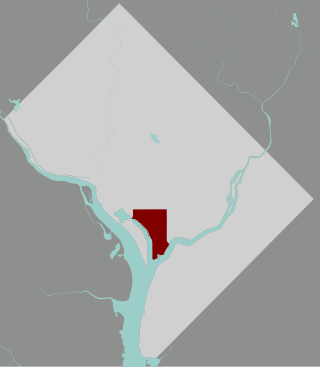
Southeast is the southeastern quadrant of Washington, D.C., the capital of the United States, and is located south of East Capitol Street and east of South Capitol Street. It includes the Capitol Hill and Anacostia neighborhoods, the Navy Yard, the Joint Base Anacostia-Bolling (JBAB), the U.S. Marine Barracks, the Anacostia River waterfront, Eastern Market, the remains of several Civil War-era forts, historic St. Elizabeths Hospital, RFK Stadium, Nationals Park, and the Congressional Cemetery. It also contains a landmark known as "The Big Chair," located on Martin Luther King Jr. Avenue. The quadrant is split by the Anacostia River, with the portion that is west of the river sometimes referred to as "Near Southeast". Geographically, it is the second-smallest quadrant of the city.

<span class="mw-page-title-main">Southwest (Washington, D.C.)</span> Southwestern quadrant of Washington, D.C.

Southwest is the southwestern quadrant of Washington, D.C., the capital of the United States, and is located south of the National Mall and west of South Capitol Street. It is the smallest quadrant of the city, and contains a small number of named neighborhoods and districts, including Bellevue, Southwest Federal Center, the Southwest Waterfront, Buzzard Point, and the military installation known as Joint Base Anacostia–Bolling.

<span class="mw-page-title-main">Neighborhoods in Washington, D.C.</span>

Neighborhoods in Washington, D.C., United States are distinguished by their history, culture, architecture, demographics, and geography. The names of 131 neighborhoods are unofficially defined by the D.C. Office of Planning. Neighborhoods can be defined by the boundaries of wards, historic districts, Advisory Neighborhood Commissions, civic associations, and business improvement districts (BIDs); these boundaries will overlap. The eight wards each elect a member to the Council of the District of Columbia and are redistricted every ten years.

<span class="mw-page-title-main">Whitney Young Memorial Bridge</span> Bridge in D.C., U.S.

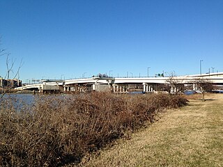
The Whitney Young Memorial Bridge is a bridge that carries East Capitol Street across the Anacostia River in Washington, D.C. in the United States. Finished in 1955, it was originally called the East Capitol Street Bridge. It was renamed for civil rights activist Whitney Young in early 1974. The bridge is 1,800 feet (550 m) long, its six lanes are 82 feet (25 m) wide, and it has 15 spans resting on 14 piers.

<span class="mw-page-title-main">11th Street Bridges</span> Complex of three bridges across the Anacostia River in Washington, D.C.

The 11th Street Bridges are a complex of three bridges across the Anacostia River in Washington, D.C., United States. The bridges convey Interstate 695 across the Anacostia to its southern terminus at Interstate 295 and DC 295. The bridges also connect the neighborhood of Anacostia with the rest of the city of Washington.

The Inner Loop was two planned freeways around downtown Washington, D.C. The innermost loop would have formed an oval centered on the White House, with a central freeway connecting the southern segment to the northern segment and then continuing on to Interstate 95. Interstate 95 would have met Interstate 66, Interstate 295, Interstate 695, and US 50 while traversing the Inner Loop. A second loop was an arc across the northern section of the city, beginning at East Capitol Street at the Anacostia River and using the Missouri Avenue NW and Nebraska Avenue NW commercial corridors to terminate in Georgetown.

<span class="mw-page-title-main">Ivy City</span> Neighborhood in Washington, D.C., U.S.

Ivy City is a small neighborhood in Northeast Washington, D.C., in the United States. About half the neighborhood is industrial or formerly industrial, dominated by warehouses. The Ivy City Yard, a railroad coach yard and maintenance facility for the passenger railroad Amtrak, is situated northwest across New York Avenue NE. Ivy City was laid out as a suburban development for African Americans in 1873. Development was slow. From 1879 to 1901, the neighborhood hosted the Ivy City Racetrack, a major horse racing facility in the District of Columbia. Construction on the rail yard began in 1907 and was complete within a year, although much of the facilities there were demolished in 1953 and 1954 as railroads switched from coal-fired locomotives to diesel-fueled or electric engines. The Alexander Crummell School, a major focal point of the community, opened in 1911. After some years of enrollment decline, it closed in 1972 but has not been demolished. The area has undergone some gentrification in the 21st century, although people living in the residential core of Ivy City remain very poor and unemployment is high.

<span class="mw-page-title-main">Barney Circle</span> Neighborhood in the United States

Barney Circle is a small residential neighborhood located between the west bank of the Anacostia River and the eastern edge of Capitol Hill in southeast Washington, D.C., in the United States. The neighborhood is characterized by its sense of community, activism, walkability, and historic feel. The neighborhood's name derives from the eponymous former traffic circle Pennsylvania Avenue SE just before it crosses the John Philip Sousa Bridge over the Anacostia. The traffic circle is named for Commodore Joshua Barney, Commander of the Chesapeake Bay Flotilla in the War of 1812.

<span class="mw-page-title-main">Kingman Island</span>

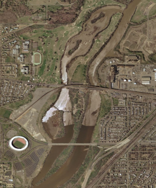
Kingman Island and Heritage Island are islands in Northeast and Southeast Washington, D.C., in the Anacostia River. Both islands are man-made, built from material dredged from the Anacostia River and completed in 1916. Kingman Island is bordered on the east by the Anacostia River, and on the west by 110-acre (45 ha) Kingman Lake. Heritage Island is surrounded by Kingman Lake. Both islands were federally owned property managed by the National Park Service until 1995. They are currently owned by the D.C. government, and managed by Living Classrooms National Capital Region. Kingman Island is bisected by Benning Road and the Ethel Kennedy Bridge, with the southern half of the island bisected again by East Capitol Street and the Whitney Young Memorial Bridge. As of 2010, Langston Golf Course occupied the northern half of Kingman Island, while the southern half of Kingman Island and all of Heritage Island remained largely undeveloped. Kingman Island, Kingman Lake and nearby Kingman Park are named after Brigadier General Dan Christie Kingman, the former head of the United States Army Corps of Engineers.

<span class="mw-page-title-main">Kingman Lake</span>

Kingman Lake is a 110-acre (0.45 km2) artificial lake located in the Anacostia River in Washington, D.C., in the United States. The lake was created in 1920 when the United States Army Corps of Engineers used material dredged from the Anacostia River to create Kingman Island. The Corps of Engineers largely blocked the flow of the Anacostia River to the west of Kingman Island, creating the lake. Kingman Lake is currently managed by the National Park Service.

<span class="mw-page-title-main">Southwest Waterfront</span> Neighborhood in Washington, D.C., United States

The Southwest Waterfront is a neighborhood in Southwest Washington, D.C. The Southwest quadrant is the smallest of Washington's four quadrants, and the Southwest Waterfront is one of only two residential neighborhoods in the quadrant; the other is Bellevue, which, being east of the Anacostia River, is frequently, if mistakenly, regarded as being in Southeast

<span class="mw-page-title-main">Navy Yard (Washington, D.C.)</span> Place in the United States

<span class="mw-page-title-main">Greenway (Washington, D.C.)</span> Neighborhood in Ward 7, United States

Greenway is a residential neighborhood in Southeast Washington, D.C., in the United States. The neighborhood is bounded by East Capitol Street to the north, Pennsylvania Avenue SE to the south, Interstate 295 to the west, and Minnesota Avenue to the east.

<span class="mw-page-title-main">River Terrace (Washington, D.C.)</span> Neighborhood in Ward 7, United States

River Terrace is an urban cul-de-sac neighborhood in Northeast Washington, D.C., on the eastern bank of the Anacostia River. River Terrace is Washington, DC's only planned unit development that has an unimpeded connection to and relationship with the Anacostia River.

<span class="mw-page-title-main">Anacostia Waterfront Corporation</span> Defunct government-owned corporation in the United States

The Anacostia Waterfront Corporation (AWC) was a government-owned corporation established in 2004 by the government of District of Columbia, in the United States, to revitalize neighborhoods next to the Anacostia River and to coordinate the environmental rehabilitation and use of the river. The corporation was intended to have a 20-year lifespan, during which it would oversee an $8 billion public-private redevelopment plan covering the Anacostia River waterfront and numerous parcels of land in the city east of the river. However, a change in mayoral administrations and frustration with the slow pace of redevelopment resulted in the abolition of the corporation after three years.

<span class="mw-page-title-main">Langston Golf Course</span>

Langston Golf Course is an 18-hole golf course in Washington, D.C., established in 1939. It was named for John Mercer Langston, an African American who was the first dean of the Howard University School of Law, the first president of Virginia Normal and Collegiate Institute, and the first African American elected to the United States Congress from Virginia. It was the second racially desegregated golf course in the District of Columbia, and in 1991 its first nine holes were added to the National Register of Historic Places.

<span class="mw-page-title-main">Committee of 100 on the Federal City</span>

The Committee of 100 on the Federal City, locally referred to as the Committee of 100, is a private, nonprofit membership organization which promotes responsible land use and planning in Washington, D.C., and advocates adherence to the L'Enfant Plan and McMillan Plan as a guide to city growth. It is one of the most influential private land use planning bodies in Washington, D.C.

References

  1. 1 2 3 Latimer, Leah Y. "An Aging Neighborhood of 'Empty Nests' Mirrors City Trend of Shifting Population." Washington Post. June 2, 1982.
  2. 1 2 3 4 Knight, Athelia. "Kingman Park Is Thriving on Community Spirit." Washington Post. April 2, 1988.
  3. 1 2 "Forty Homes Purchased From Charles D. Sager." Washington Post. July 15, 1928.
  4. 1 2 Forgey, Benjamin. "The Anacostia, Stream of Consciousness." Washington Post. March 28, 1987
  5. "Lake Kingman Wall Bids Are Received." Washington Post. March 10, 1926; "$170,000 Annually Spent Developing Park in Anacostia," Washington Post, September 26, 1926.
  6. 1 2 3 4 5 Gutheim, Frederick A. and Lee, Antoinette J. Worthy of the Nation: Washington, DC, From L'Enfant to the National Capital Planning Commission. Baltimore, Md.: Johns Hopkins University Press, 2006, p. 147.
  7. 1 2 Coues, Elliott and Prentiss, D. Webster. "Avifauna Columbiana." Bulletin of the United States National Museum. No. 26. Washington, D.C.: U.S. Government Printing Office, 1883, p. 17.
  8. Report of the Chief of Engineers, U.S. Army. United States Army. Corps of Engineers. Washington, D.C.: U.S. Government Printing Office, 1876, p. 357.
  9. "To Dredge Anacostia River." Washington Post. August 9, 1902.
  10. 1 2 3 Gutheim and Lee, Worthy of the Nation, 2006, p. 148.
  11. "Flats Soon to Go." Washington Post. October 10, 1909.
  12. "For A Park on Flats." Washington Post. November 5, 1905.
  13. Bryan, Wilhelmus Bogart. A History of the National Capital From Its Foundation Through the Period of the Adoption of the Organic Act. New York: The Macmillan Company, 1914, p. 492.
  14. Croggon, James. "When City Was Young." Washington Evening Star. August 17, 1906.
  15. Bryan, A History of the National Capital From Its Foundation Through the Period of the Adoption of the Organic Act, 1914, p. 98-99.
  16. Wasserman, Paul and Hausrath, Don. Washington, D.C. from A to Z: The Traveler's Look-Up Source for the Nation's Capital. Sterling, Va.: Capital Books, 2003, p. 33.
  17. Wheeler, Linda. "Benning Heights' Twists and Turns." Washington Post. October 25, 1997.
  18. 1 2 3 Duggan, Paul. "Home Team, Home Fears." Washington Post. April 8, 1991.
  19. 1 2 3 4 "750 Homes Planned For Kingman Park." Washington Post. February 15, 1931.
  20. 1 2 "New Schools for Which Names Will Be Chosen." Washington Post. May 13, 1930.
  21. A "platoon school" (also known as a "work-study-play" school, "Gary system," and "departmental" system) is a system of education where children are assigned to two or more "platoons." The system arose as a means of handling extreme overcrowding in schools. Under the platoon system, one platoon works on one educational subject while the other platoon works on a different educational subject. After a designated period of time (e.g., an hour), the platoons switch to another subject, often by moving to another classroom. By the end of the school day, all platoons will have studied all subjects. The platoon system is in contrast to the "self-contained" system, where a single teacher teaches all subjects in a single classroom. The system was devised by Gary, Indiana, public school superintendent William Albert Wirt in the first decade of the 1900s. See: Diemer, G.W. "The Platoon School." The Elementary School Journal. June 1925; Case, Roscoe David. The Platoon School in America. Palo Alton, Calif.: Stanford University Press, 1931.
  22. "School Projects Will Be Advanced." Washington Post. November 15, 1930.
  23. 1 2 3 "Projects Advance in Northeast Area." Washington Post. April 26, 1931.
  24. 1 2 "Furniture Supposed to Be in Schools Is Still Missing." Washington Post. September 23, 1931.
  25. "Col. Charles Young Dies in Nigeria." New York Times. January 13, 1922; "Memorial Service Honors Col. Young." Washington Post. January 26, 1931.
  26. "Negro Elementary Schools Graduate Large Numbers." Washington Post. January 31, 1932.
  27. After several years of declining enrollment, Young Elementary School closed in 2008. The District of Columbia Department of Parks and Recreation leases the building from the school district. See: "Labba, Theola and Haynes, V. Dion. "Schools Targeted For Closure." Washington Post. January 13, 2008; Haynes, V. Dion. "2 Closed Schools Go to Charters." Washington Post. June 21, 2008.
  28. 1 2 3 McQuirter, Marya Annette. "'Our Cause Is Marching On': Parent Activism, Browne Junior High School, and the Multiple Meanings of Equality in Post-War Washington." Washington History. 16:2 (Fall/Winter 2004/2005), p. 68.
  29. 1 2 Miller, Frederic and Gillette, Howard. Washington Seen: A Photographic History, 1875-1965. Baltimore, Md.: Johns Hopkins University Press, 1995, p. 159.
  30. Brown, Sterling Allen. A Son's Return: Selected Essays of Sterling A. Brown. Boston: Northeastern University Press, 1996, p. 40.
  31. Abrams, Brett L. Capital Sporting Grounds: A History of Stadium and Ballpark Construction in Washington, D.C. Jefferson, N.C.: McFarland, 2009, p. 202.
  32. 1 2 Castaneda, Ruben. "NE Neighborhood Rallies Against Football Stadium." Washington Post. June 26, 1991.
  33. Chan, Sewell. "Racial Shifts Complicate Ward Plan." Washington Post. April 5, 2001; Chan, Sewell and Goldstein, Avram. "Ward Boundary Remapping Stirs Race Tension." Washington Post. April 26, 2001.
  34. Chan, Sewell. "D.C. Panel Approves Redistricting Blueprint." Washington Post. May 3, 2001; Chan, Sewell and Bacon, Jr., Perry. "D.C. Council Adopts Overhaul of Wards." Washington Post. June 20, 2001.
  35. Kingman Park Civic Association and Chevy Chase Civic Association v. Anthony A. Williams, et al., 348 F.3d 1033 (2003).
  36. Kingman Park Civic Association et al. v. Anthony A. Williams, et al., 924 A.2d 979 (2007).
  37. 1 2 Gorney, Cynthia. "Neighbors' Unity Wins Fight Against Metro Station." Washington Post. June 12, 1977.
  38. Schrag, Zachary M. The Great Society Subway: A History of the Washington Metro. Baltimore, Md.: Johns Hopkins University Press, 2006, p. 161.
  39. 1 2 3 Wheeler, Linda. "D.C. Freeway in Limbo." Washington Post. August 21, 1995.
  40. 1 2 Lynton, Stephen J. "D.C. Plans to Link Two City Freeways." Washington Post. September 26, 1983.
  41. 1 2 Lippman, Thomas W. "D.C. Is Planning $850 Million For Maintenance, New Projects." Washington Post. January 5, 1981.
  42. Lynton, Stephen J. "D.C. Reviving Long-Controversial Anacostia Road Plan." Washington Post. July 7, 1985.
  43. Spencer, Duncan. "Hill Faces Another Classic Battle Over a Freeway." Roll Call. June 18, 1992.
  44. Castaneda, Ruben. "Construction to Begin in '94 On Anacostia-SE Freeway Link." Washington Post. September 17, 1993.
  45. Spencer, Duncan. "Road Project Hits Legal Dead End." Roll Call. February 3, 1994.
  46. 1 2 Cohn, D'Vera. "Suit Seeks to Stop D.C. Plans to Build Connector Highway." Washington Post. May 13, 1994.
  47. 1 2 Neufeld, Matt. "People Sue to Stop SE Freeway Proposal." Washington Times. May 13, 1994.
  48. Loeb, Vernon. "Norton Declares Barney Circle Freeway a Dead End." Washington Post. March 5, 1997.
  49. Wheeler, Linda. "Neighbors Feel Left on Sidelines During Talks on New Stadium." Washington Post. September 17, 1988.
  50. Ragland, James. "NE Neighbors Uneasily Eye Stadium Plans." Washington Post. February 1, 1992; Wheeler, Linda. "Some Residents Hope to Block That Stadium." Washington Post. December 14, 1992; Ragland, James. "Neighbors Dig In on Stadium." Washington Post. February 9, 1993.
  51. Abrams, Capital Sporting Grounds: A History of Stadium and Ballpark Construction in Washington, D.C., 2009, p. 210, 218.
  52. Harris, Hamil R. "Redskins' Move Leaves Dry Eyes." Washington Post. December 10, 1995.
  53. Loeb, Vernon. "Anacostia River Theme Park Again on Hold." Washington Post. October 7, 1997; Loeb, Vernon. "Theme Park Deal Troubles City Lawyer." Washington Post. October 19, 1997.
  54. Hsu, Spencer S. "Lawsuits Seek to Enforce More Extensive Pollution Limits." Washington Post. August 9, 1998.
  55. Kovaleski, Serge F. "D.C. Panel Ignored Car Race's Environmental Impact." Washington Post. May 19, 2002; Kovaleski, Serge F. "Unwillingly, Grand Prix Neighbors Off to Races." Washington Post. July 20, 2002; Kovaleski, Serge F. "Grand Prix Firm Misled D.C. Agency On Sound Barrier." Washington Post. July 28, 2002.
  56. Kovaleski, Serge F. "Car-Race Barriers Still Clog RFK Lots." Washington Post. April 3, 2003.
  57. Kovaleski, Serge F. "D.C. Panel Blamed in Canceled Race." Washington Post. March 9, 2003; Kovaleski, Serge F. "D.C. Agency Cancels Grand Prix Contract." Washington Post. April 5, 2003.
  58. Dvorak, Petula. "Kingman Park Fights a School Many Praise." Washington Post. May 7, 2006.
  59. Nakamura, David. "RFK Fireworks Plan Stamped Out." Washington Post. March 3, 2005.
  60. "Kingman Park is growing, but its 'small town' values have remained". Washington Post. ISSN   0190-8286 . Retrieved 2023-03-07.
  61. "Kingman Park is growing, but its 'small town' values have remained". Washington Post. ISSN   0190-8286 . Retrieved 2023-03-08.