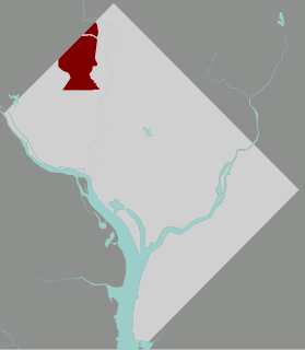
Last updated Map of Washington, D.C., with Hawthorne highlighted in redNear the intersection of 32nd St. and Chestnut St. NW, in Hawthorne, in July 2021.
Hawthorne is a neighborhood of 308 single family homes in the Northwest quadrant of Washington, D.C.[1] According to neighborhood lore, the subdivision was named for the hawthorn trees once abundant in the area.[1] The neighborhood borders Montgomery County, Maryland, and is bounded by Pinehurst Tributary to the south, Western Avenue to the northwest, and Rock Creek Park to the east.[1]
This neighborhood was originally inhabited by wealthy African Americans, mostly doctors, lawyers, and professors. Most of these families were alumni and faculty of Howard University from 1969 to about 2005. Hawthorne is entirely residential, with no commercial zoning, and is occupied by 1940s-era large split-level and rambler houses on very large parcels. The neighborhood is suburban, separated from the roar of life in the nation's capital.
The area is part of the Chevy Chase Citizens Association and residents consider themselves residents of Chevy Chase.[1] The neighborhood is known for its abundance of mature trees and green space.[1][2] Most of the neighborhood's housing stock was built in the 1940s.[1]Ranch-style and split-level homes predominate, although there are some Colonial, Cape Cod, and modern-style homes.[1]
Hawthorne students are zoned to Lafayette Elementary School, Alice Deal Middle School, and Jackson-Reed High School.[1]
Chevy Chase Section Five is an incorporated village in Montgomery County, Maryland, United States. The population was 658 at the 2010 census.
Chevy Chase Village, Maryland is an incorporated municipality in Montgomery County, Maryland, United States, bordering Washington, D.C. It is made up of sections 1, 1a, and 2 of Chevy Chase, as originally designated by The Chevy Chase Land Company. The population was 1,953 as of the 2010 census. The town is the wealthiest in Maryland, with a median income of over $250,000, the highest income bracket listed by the census bureau, and a median home value of $1,823,800.
Chevy Chase is the name of both a town and an unincorporated census-designated place that straddle the northwest border of Washington, D.C. and Montgomery County, Maryland, United States. Several settlements in the same area of Montgomery County and one neighborhood of Washington include Chevy Chase in their names. These villages, the town, and the CDP share a common history and together form a larger community colloquially referred to as Chevy Chase.
Chevy Chase is an incorporated town in Montgomery County, Maryland, United States. The population was 2,824 at the 2010 census.
Southeast is the southeastern quadrant of Washington, D.C., the capital of the United States, and is located south of East Capitol Street and east of South Capitol Street. It includes the Capitol Hill and Anacostia neighborhoods, the Navy Yard, the Joint Base Anacostia-Bolling (JBAB), the U.S. Marine Barracks, the Anacostia River waterfront, Eastern Market, the remains of several Civil War-era forts, historic St. Elizabeths Hospital, RFK Stadium, Nationals Park, and the Congressional Cemetery. It also contains a landmark known as "The Big Chair," located on Martin Luther King Jr. Avenue. The quadrant is split by the Anacostia River, with the portion that is west of the river sometimes referred to as "Near Southeast". Geographically, it is the second-smallest quadrant of the city.
Northwest is the northwestern quadrant of Washington, D.C., the capital of the United States, and is located north of the National Mall and west of North Capitol Street. It is the largest of the four quadrants of the city, and it includes the central business district, the Federal Triangle, and the museums along the northern side of the National Mall, as well as many of the District's historic neighborhoods.
Friendship Heights is an urban commercial and residential neighborhood in northwest Washington, D.C. and southern Montgomery County, Maryland. Though its borders are not clearly defined, Friendship Heights consists roughly of the neighborhoods and commercial areas around Wisconsin Avenue north of Fessenden Street NW and Tenleytown to Somerset Terrace and Willard Avenue in Maryland, and from River Road in the west to Reno Road and 41st Street in the east. Within Maryland west of Wisconsin Avenue is the Village of Friendship Heights, technically a special taxation district.
Deanwood is a neighborhood in Northeast Washington, D.C., bounded by Eastern Avenue to the northeast, Kenilworth Avenue to the northwest, Division Avenue to the southeast, and Nannie Helen Burroughs Avenue to the south.
Crestwood is an entirely residential neighborhood located in Northwest Washington, D.C. and bordered on three sides by Rock Creek Park. Heading north from the White House on 16th Street, Crestwood is among the first neighborhoods that features single-family homes with larger lawns. It has many mature trees, and it is not uncommon to see deer and other wildlife from the park crossing the streets there.
Shepherd Park is a neighborhood in the northwest quadrant of Washington, D.C. In the years following World War II, restrictive covenants which had prevented Jews and African Americans from purchasing homes in the neighborhood were no longer enforced, and the neighborhood became largely Jewish and African American. Over the past 40 years, the Jewish population of the neighborhood has declined, but the neighborhood has continued to support a thriving upper and middle class African American community. The Shepherd Park Citizens Association and Neighbors Inc. led efforts to stem white flight from the neighborhood in the 1960s and 1970s, and it has remained a continuously integrated neighborhood, with very active and inclusive civic groups.
Chevy Chase is a neighborhood in northwest Washington, D.C. It borders Chevy Chase, Maryland, a collection of similarly affluent neighborhoods.
Manor Park is a neighborhood in Ward 4 of northwest Washington, D.C. The National Capital Planning Commission 1967 "District Communities" map indicates this neighborhood is roughly bounded between 8th Street NW to the west, North Capitol Street NW, Blair Road NW, and the Washington Metropolitan Area Red Line train tracks to the east, Rittenhouse Street NW to the north, and Missouri Avenue NW to the south. Manor Park borders the adjacent neighborhoods of Takoma Park, Brightwood, and Brightwood Park in NW Washington D.C. and also borders the Riggs Park neighborhood in NE Washington D.C. In 1940, the Manor Park Citizens Association deemed the boundaries to be Eighth Street, Whittier Street, North Capitol Street, and Concord Street.
Wakefield is a neighborhood in the Northwest quadrant of Washington, D.C., bounded by Albemarle Street NW to the south, Nebraska Avenue NW to the west, and Connecticut Avenue to the east. It is served by the Van Ness-UDC and Tenleytown-AU station on the Washington Metro's Red Line.
Downtown is a neighborhood of Washington, D.C., as well as a colloquial name for the central business district in the northwest quadrant of the city. It is the fourth largest central business district in the United States. Historically, the Downtown has been defined as an area east of 16th Street NW, north of the National Mall and US Capitol complex, and south of Massachusetts Avenue, including the Penn Quarter. However, the city says that most residents, workers, and visitors think of Downtown in a broader sense—including areas as far north as Dupont Circle, the Golden Triangle, as far west as Foggy Bottom, and as far east as Capitol Hill. A small portion of this area is known as the Downtown Historic District and was listed on the NRHP in 2001.
The Collection is a set of shops and restaurants near the Friendship Heights Metro station on Wisconsin Avenue in Chevy Chase, Maryland, along the Washington, D.C.-Maryland border. The area was developed by the Chevy Chase Land Company, founded in 1890 by U.S. Senator Francis G. Newlands, who acquired a great deal of property in the D.C. area. The shopping area now called The Collection was built in the 1950s, one of the two first strip shopping centers in suburban Maryland. The 194,646-square-foot shopping center shopping was updated between 2017 and June 2019. The updates shifted its focus from luxury retail establishments to casual restaurants and stores.
Adair Park is a residential neighborhood located southwest of downtown Atlanta. It has the form of a left curly bracket, bordered by the MARTA north-south rail line on the northwest, the BeltLine trail on the southwest and Metropolitan Parkway on the east. Historically Adair Park also included the area from Metropolitan Parkway to McDaniel Street on the east, but the city now considers that area part of the Pittsburgh neighborhood.
Chevy Chase Circle is a traffic circle straddling the border of Chevy Chase, Washington, D.C. and Chevy Chase, Maryland. It sits upon the convergence of Western Avenue, Grafton Street, Magnolia Parkway, Chevy Chase Parkway NW, and Connecticut Avenue.
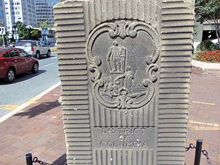
The Garden Club of America Entrance Markers in Washington, D.C. is a Multiple Property Submission, or MPS, on the National Register of Historic Places. The seven structures that make up the MPS are ceremonial markers at important entrance points to the District of Columbia from the state of Maryland. Sets of two markers are located in Westmoreland Circle, Friendship Heights and Chevy Chase Circle. A single marker is located along Georgia Avenue.
The Willoughby of Chevy Chase is a large high-rise condominium building in Montgomery County, Maryland, on the outskirts of Washington, D.C. It was originally designed by award-winning, modernist architect Vlastimil Koubek and opened in 1969 as the Willoughby Apartments. The Willoughby Apartments was built for luxury rentals, and when it opened, it was the largest residential building in the DC area.
Woodmont is a neighborhood in northwest Washington, D.C.
This page is based on this Wikipedia article Text is available under the CC BY-SA 4.0 license; additional terms may apply. Images, videos and audio are available under their respective licenses.