British Columbia Highway 17

Last updated

BC-17.svg

Highway 17

Patricia Bay Highway (Vancouver Island section)
South Fraser Perimeter Road (Mainland section)
British Columbia Highway 17
Highway 17 highlighted in red, bottom left shows Highway 17 on Vancouver Island.
Route information
Maintained by British Columbia Ministry of Transportation and Infrastructure
Length121 km [1] [2]  (75 mi)
Existed1960–present
Vancouver Island section
Length33 km (21 mi)
South endBritish Columbia G-050-5.svg Victoria Harbour ferry terminal
Major intersectionsBC-1 (TCH).svg Hwy 1 (TCH) in Victoria
North endBritish Columbia G-050-5.svg Swartz Bay Ferry Terminal
Mainland section
Length44 km (27 mi)
West endBritish Columbia G-050-5.svg Tsawwassen Ferry Terminal
Major intersectionsBC-17A.svg Hwy 17A in Delta
BC-99.svg Hwy 99 in Delta
BC-91.svg Hwy 91 in Delta (via Hwy 91C)
East endBC-1 (TCH).svgBC-15.svg Hwy 1 (TCH)  / Hwy 15 in Surrey
Location
Country Canada
Province British Columbia
Regional districts Saanich, Central Saanich, North Saanich
Major cities Victoria, Delta, Surrey
Highway system
    BC-16 (TCH).svg Hwy 16 BC-17A.svg Hwy 17A

    Highway 17 is a provincial highway in British Columbia, Canada. It comprises two separate sections connected by a ferry link. The Vancouver Island section is known as the Patricia Bay Highway and connects Victoria to the Swartz Bay ferry terminal in North Saanich. The Lower Mainland section is known as the South Fraser Perimeter Road and connects the Tsawwassen ferry terminal to Delta and Surrey, terminating at an interchange with Highway 1 in the Fraser Valley.

    Contents

    Route description

    Vancouver Island section

    The Island section of Highway 17 is known as the Patricia Bay Highway (locally abbreviated as the Pat Bay Highway) after nearby Patricia Bay, and is the main artery through the Saanich Peninsula, mostly travelling along its eastern coast. The highway is four lanes all the way from Victoria to Swartz Bay. The total length of the highway on the Island is 32 kilometres (20 mi). Highway 17 has had its present course through the area since 1978 when the Blanshard extension was completed. [3]

    In the south, Highway 17 begins at the intersection of Belleville and Oswego streets, [4] at the entrance to the Victoria Harbour ferry terminal, which provides a ferry connection to Port Angeles, Washington. It travels east for 600 m (0.37 mi), past the grounds of the British Columbia Parliament Buildings, to Douglas Street where it intersects the Trans-Canada Highway (Highway 1). It travels another 180 m (0.11 mi) east, where the highway turns north as Blanshard Street (a six lane divided city street) for 3 km (1.9 mi) through the city of Victoria before leaving the city at Tolmie Avenue and for another 2 km (1.2 mi) north through the district of Saanich to the Uptown Shopping Centre; Highway 17 then becomes the Pat Bay Highway and turns into a 6 km (3.7 mi)-long freeway, with three interchanges. After the third interchange at Royal Oak Drive, Highway 17 turns into a 14 km (8.7 mi) mix of divided four-lane arterial and expressway including an interchange at McTavish Road, until it reaches the town of Sidney. After exiting Sidney 3 km (1.9 mi) later, the Pat Bay once again becomes a freeway, with two more interchanges along its length, toward its northern terminus at the Swartz Bay ferry terminal another 3 km (1.9 mi) north.

    Ferry route

    At Swartz Bay, Highway 17 leaves Vancouver Island, and starts on a 44 km (24 nmi)-long ferry route through the Southern Gulf Islands and the Strait of Georgia. The ferry route between Swartz Bay and the Mainland is the oldest and most heavily used route in the B.C. Ferries system. After winding through the Gulf Islands, the route enters a small passage between Galiano and Mayne Islands, known as Active Pass. Active Pass is the midway point on the Highway 17 ferry route, but it is also the most hazardous part, as it has strong tidal currents, and has historically been the site of two maritime collisions involving BC Ferries vessels, as well as one incident of a ferry running aground. Consequently, ferries going through Active Pass have to sound their whistles upon entering and leaving the passage, and must adhere to a lower speed limit while transiting through it.

    After Active Pass, the Highway 17 ferry heads due northeast across the Strait of Georgia. Halfway across the Strait, the route begins transiting United States waters for just under 9 km (5 nmi). It then crosses the 49th parallel back into Canadian waters just before landing at the Tsawwassen Ferry Terminal.

    Mainland section

    Highway 17 looking South near Port Mann (Surrey) British Columbia. New and old Port Mann Bridge in background. Highway17PortMann.JPG
    Highway 17 looking South near Port Mann (Surrey) British Columbia. New and old Port Mann Bridge in background.

    On the Mainland, Highway 17 is known as the South Fraser Perimeter Road (SFPR), a component of the British Columbia Ministry of Transportation's Gateway Program. It is a four-lane highway with a mix of freeway and expressway sections. The highway has a speed limit of 80 km/h (50 mph) over most of its length, connecting the Tsawwassen Ferry Terminal and Highway 99 in Delta to Highway 1 at 176th Street in Surrey, and providing access to all five of the major Fraser River crossings in Metro Vancouver. [5] The mainland section is notable for its extensive use of noise walls, split level construction through Delta and use in some urban sections of so-called Quiet Pavement to reduce traffic noise. [6]

    The South Fraser Perimeter Road is 44 kilometres (27 mi) long. Beginning at the Tsawwassen Ferry Terminal, it heads northeast on a 1.8-kilometre (1.1 mi) long causeway to land on the Tsawwassen Peninsula, then continues northeast for 5 kilometres (3.1 mi) to an interchange with Highway 17A. It then follows the CN Railway's Deltaport chord and 72nd Street northeast for 6.2 kilometres (3.9 mi) to an interchange with Highway 99. The road then runs through the west side of Burns Bog, but avoiding the conservation area, and past the south side of the Tilbury and Sunbury industrial areas for 9.7 kilometres (6.0 mi) before it reaches the Fraser River at an interchange connecting to Highway 91 via Highway 91 Connector. It then proceeds east along the south bank of the Fraser River through North Delta and Surrey, passing under the Alex Fraser, Pattullo and Port Mann bridges, before turning southeast at Surrey Bend Regional Park to terminate at its junction with Highway 1 and Highway 15, 21 kilometres (13 mi) from Highway 91 Connector.

    History

    Vancouver Island Section

    Prior to 1978, the southern terminus of Highway 17 was at the present-day intersection of Highway 1 (Douglas Street) and Carey Road. In 1978, the highway was extended and aligned along Blanshard Street through Downtown Victoria to the Inner Harbour in an effort to improve traffic flow. [7]

    South Fraser Perimeter Road

    Route 17 once followed what is now Route 17A and terminated at the Highway 99 interchange before the George Massey Tunnel. The provincial government proposed to build a new expressway, the South Fraser Perimeter Road (SFPR), linking the Tsawwassen Ferry Terminal with the Trans-Canada Highway. According to the Ministry of Transportation, the South Fraser Perimeter Road will improve the movement of goods and people across the region while also alleviating truck traffic on municipal roads. West–east travel times across the region will also be significantly reduced. [8]

    The South Fraser Perimeter Road project was opposed by a number of groups, citing a variety of concerns. The SFPR alignment does not go through the Burns Bog Ecological Conservancy Area. [9] However, the Burns Bog Conservation Society has stated they are concerned that it will affect surrounding hydrology, and have an adverse effect on the Conservancy Area. [10]

    The Burns Bog Conservation Society expressed concerns that the South Fraser Perimeter Road would endanger Burns Bog. [11] In response to the mitigation measures proposed the Environmental Stewardship Branch of Environment Canada wrote that "... the changes are not sufficient to alleviate its concerns related to the impacts of the Project on Pacific Water Shrew (PWS), hydrology, aerial deposition, and ecological integrity of Burns Bog." [12] On November 24, 2010 the Burns Bog Conservation Society launched a lawsuit intend to force the re-routing or cancellation of the SFPR project. [13] Burns Bog has been listed as threatened by the International Mire Conservation Group because of the impacts of the SFPR. [14]

    The Wilderness Committee and other groups have criticized the SFPR, and the Gateway Program in general, for increasing greenhouse gas emissions. [15] In early 2011, a protest camp organized by StopThePave.org and the Council of Canadians occupied a SFPR construction site for almost two weeks. [16]

    The SFPR Project worked with the Burns Bog Scientific Advisory Panel to develop systems, which helped improve the existing drainage / hydrology of the bog.

    A 10-kilometre-long (6.2 mi) portion from 136 Street in Surrey to a junction with Highway 15 and Highway 1 was the first portion of the SFPR to be completed, opening on December 1, 2012. The remaining western segment of the road was completed on December 21, 2013. [17] The former Mainland portion of Highway 17 north of the 28th Avenue overpass has been renamed to Highway 17A through Ladner. [6] The total cost of building the SFPR was $1.26 billion. [18]

    On March 10, 2017, an announcement was made to address congestion at Highway 17 (Delta): an extension of westbound slip lane from Tilbury Connector (80th Avenue) intersection, replacement of the traffic light-controlled Highway 91 Connector with an interchange, and construction of a new interchange at River Road. This would make the road a freeway all the way to Tannery Road. Funding will come from the Canadian government, the BC Government, the Vancouver Fraser Port Authority, and the Tsawwassen First Nation; the total cost is expected to be just over $245 million. [19] Construction started in spring 2020 and the new River Road interchange opened on December 3, 2021. [20] The new Highway 91 Connector interchange reached completion in November 2022. [21] [22]

    Future

    On Vancouver Island, there have been numerous studies to upgrade the Island portion of Highway 17 to freeway standard. This seems to be edging closer with the BC Government's issuing of the Highway 17 Corridor Planning Strategy. This study envisions interchanges at Haliburton, Sayward, Keating Cross Road and/or Island View, Mt Newton Cross Road, McTavish Road (Complete April 9, 2011) and Beacon Avenue in Sidney. Construction of a flyover ramp from northbound Highway 17 to Keating Cross Road commenced in June 2023. [23]

    As part of the Pattullo Bridge replacement project, the initial plan included a new interchange to provide direct connections to and from Highway 17 to the bridge as well as an extension of Scott Road north of King George Boulevard to directly connect with Highway 17 to divert traffic from local streets in Surrey. However, the project was down-scaled as the study showed Highway 17 cannot handle increased traffic from induced demand and the significant traffic delay would be expected on the provincial road network. [24] Under the final proposal tendered in 2020, the only direct connection from the Pattullo Bridge would be from eastbound Pattullo Bridge to westbound, while Highway 17 and Old Yale Road intersection will be closed and grade-separated. [25]

    Major intersections

    Regional DistrictLocationkm [1] [2] miExitDestinationsNotes
    Capital Victoria 0.000.00British Columbia G-050-5.svg Oswego Street / Belleville Street – Ferry TerminalSouthern terminus; Belleville Street continues west; Black Ball Ferries to Port Angeles; Victoria Clipper passenger ferry to Seattle
    0.600.37BC-1 (TCH).svg Douglas Street (Hwy 1 (TCH)) Nanaimo At-grade, traffic signals
    1.300.81Blanshard StreetHwy 17 turns north onto Blanshard Street
    1.600.99Johnson StreetAt-grade, traffic signals; one-way eastbound
    1.701.06Pandora AvenueAt-grade, traffic signals; one-way westbound; access to Johnson Street Bridge
    4.002.49Tolmie AvenueAt-grade, traffic signals
    North end of City of Victoria jurisdiction
    Saanich 4.863.02South end of one-way pair; northbound becomes Vernon Avenue, southbound remains Blanshard Street
    4.913.05Saanich RoadAt-grade, traffic signals
    5.623.49BC-17.svg Hwy 17 south (Blanshard Street) City Centre At-grade, traffic signals; northbound exit and southbound entrance; north end of one-way pair; becomes Patricia Bay Highway
    6.564.087BC-1 (TCH).svgBC-14.svg McKenzie Avenue to Hwy 1 (TCH)  / Hwy 14  Nanaimo, Sooke Interchange
    8.065.018Vanalman AvenueSouthbound right-in/right-out
    8.735.429Quadra Street east, West Saanich RoadInterchange; no southbound access to westbound West Saanich Road
    10.126.2911Royal Oak Drive Brentwood Bay Interchange; former Hwy 17A north
    11.857.36Elk Lake Drive, Haliburton RoadAt-grade, traffic signals; unsigned exit 13
    14.499.0015Sayward Road – Cordova BayAt-grade, traffic signals
    Central Saanich 17.5210.8918British Columbia G-050-5.svg Keating Cross Road Brentwood Bay, Mill Bay At-grade, northbound exit and southbound entrance only; to Butchart Gardens. Will be replaced with flyover by 2025.
    18.4711.4819Island View RoadAt-grade, traffic signals; southbound access to Keating Cross Road.
    20.9613.0221Mt. Newton Cross Road Saanichton, Brentwood Bay At-grade, traffic signals
    North Saanich 25.2515.6926Ontario M502.svgBritish Columbia G-050-5.svg McTavish Road – Airport, USA ferries Interchange; Washington State Ferries to San Juan Islands and Anacortes
    Sidney 27.4417.0528Beacon AvenueAt-grade, traffic signals
    North Saanich 30.9019.2031McDonald Park Road, Wain Road Deep Cove Interchange; former Hwy 17A south
    32.2620.0533Lands End RoadInterchange; northbound exit, southbound entrance
    32.5420.22British Columbia G-050-5.svg Swartz Bay Ferry Terminal Northern end of Vancouver Island section
    Strait of Georgia BC Ferries
    Metro Vancouver Delta 0.000.00British Columbia G-050-5.svg Tsawwassen Ferry Terminal Western end of Mainland section
    2.731.70Tsawwassen DriveAt-grade, traffic signals
    3.382.10Salish Sea DriveAt-grade, traffic signals
    4.312.6852 StreetAt-grade, traffic signals
    5.323.3156 Street Tsawwassen, Point Roberts At-grade, traffic signals
    6.864.267BC-17A.svg Hwy 17A north Ladner Eastbound exit; westbound entrance
    7.604.728Deltaport Way Roberts Bank Westbound exit; eastbound entrance
    13.098.1313BC-99.svgOntario M502.svg Hwy 99  Airport (YVR), Vancouver, USA Border, Seattle Interchange, Hwy 99 exit 26; no direct access from Hwy 17 west to Hwy 99 south
    19.3011.9980th Street (via Tilbury Connector)At-grade, traffic signals
    23BBC-91.svgOntario M502.svg Hwy 91C to Hwy 91  North Delta, Richmond, Airport, Vancouver Free-flow interchange to Hwy 91C and Alex Fraser Bridge; [26] Hwy 91 exit 8
    22.7514.1496 StreetReplaced by exit 23A; former at-grade, traffic signals
    22.9614.2723ARiver Road WestInterchange; no eastbound exit from Hwy 17 [27] [28]
    24.0114.92Passes under the Alex Fraser Bridge
    Surrey 27.2116.91Elevator RoadClosed; [29] Former westbound right-in/right-out
    29.21–
    29.69
    18.15–
    18.45
    31Tannery Road – Surrey Port, New Westminster Interchange; to Pattullo Bridge; eastbound exit ramp includes direct right-in/right-out ramps to/from 103A Avenue;
    30.4318.91 Old Yale Road At-grade, traffic signals; intersection closing by 2023 after grade-separation [25]
    Pattullo Bridge (Under Construction)Interchange; westbound entrance from eastbound Patullo Bridge; expected completion by 2023 [25]
    30.9519.23Passes under the Pattullo Bridge
    31.6919.6933124 StreetEastbound right-in/right-out
    32.9920.50Bridgeview Drive to King George Boulevard  Surrey City Centre, New Westminster At-grade, traffic signals; to Pattullo Bridge
    34.2021.25136th StreetAt-grade, traffic signals
    36.7322.82Passes under the Port Mann Bridge
    North Surrey Truck Parking Facility (Under Construction)At-grade, seagull intersection; traffic signals for westbound traffic; to North Surrey Truck Parking Facility [30]
    42.8926.65Golden Ears Connector, 104 AvenueAt-grade, traffic signals, access to Golden Ears Way
    44.1427.43BC-1 (TCH).svg Hwy 1 (TCH)  Hope, Vancouver
    BC-15.svg Hwy 15 south (176th Street) USA border
    Interchange, eastern terminus; Hwy 1 exit 53; road continues as Hwy 15 south
    1.000 mi = 1.609 km; 1.000 km = 0.621 mi

    Related Research Articles

    <span class="mw-page-title-main">Trans-Canada Highway</span> Transcontinental highway system in Canada

    The Trans-Canada Highway is a transcontinental federal–provincial highway system that travels through all ten provinces of Canada, from the Pacific Ocean on the west coast to the Atlantic Ocean on the east coast. The main route spans 7,476 km (4,645 mi) across the country, one of the longest routes of its type in the world. The highway system is recognizable by its distinctive white-on-green maple leaf route markers, although there are small variations in the markers in some provinces.

    <span class="mw-page-title-main">Delta, British Columbia</span> City in Canada

    Delta is a city in the Lower Mainland region of British Columbia, Canada, as part of Greater Vancouver. Located on the Fraser Lowland south of Fraser River's south arm, it is bordered by the city of Richmond on the Lulu Island to the north, New Westminster to the northeast, Surrey to the east, the Boundary Bay and the American pene-exclave Point Roberts to the south, and the Strait of Georgia to the west.

    Highway 1 is a provincial highway in British Columbia, Canada, that carries the main route of the Trans-Canada Highway (TCH). The highway is 1,047 kilometres (651 mi) long and connects Vancouver Island, the Greater Vancouver region in the Lower Mainland, and the Interior. It is the westernmost portion of the main TCH to be numbered "Highway 1", which continues through Western Canada and extends to the Manitoba–Ontario boundary. The section of Highway 1 in the Lower Mainland is the second-busiest freeway in Canada, after Ontario Highway 401 in Toronto.

    <span class="mw-page-title-main">British Columbia Highway 17A</span> Highway in British Columbia

    Highway 17A is a 6 km (3.7 mi) long route connecting Highway 99 and Highway 17; this route was originally numbered Highway 17 between these two points but the numbering was altered once the South Fraser Perimeter Road neared completion.

    Highway 99 is a provincial highway in British Columbia that runs 377 kilometres (234 mi) from the U.S. border to near Cache Creek, serving Greater Vancouver and the Squamish–Lillooet corridor. It is a major north–south artery within Vancouver and connects the city to several suburbs as well as the U.S. border, where it continues south as Interstate 5. The central section of the route, also known as the Sea to Sky Highway, serves the communities of Squamish, Whistler, and Pemberton. Highway 99 continues through Lillooet and ends at a junction with Highway 97 near Cache Creek.

    Highway 10 is a minor east-west route through the southern portion of Greater Vancouver. Highway 10 is used mainly as a local access route in North Delta, Surrey and Langley, its former connector role between South Delta and Highway 1 having been taken over by the Highway 17.

    Highway 99A is a series of former highways in the southwestern part of British Columbia, Canada. It was the designation of the former 1942 alignment of Highway 99 as well a various alternate routes which existed in the 1950s and 1960s. The last official use of '99A' was decommissioned in 2006, although some present-day, commercially published road maps still show it and some remnant signage still remains. Some brand new 99A signs can be seen as well as of 2023.

    Highway 91 is an alternative freeway route to Highway 99 through Delta, New Westminster and Richmond, British Columbia. The highway was built in two sections, the first section from Delta to East Richmond in 1986, and the second section across Richmond in 1989.

    There are many roads in the southwestern part of British Columbia and Vancouver Island that were designated as Highway 1A. These roads were sections of the original 1941 route of Highway 1 before its various re-alignments, and are used today as service routes and frontage roads. The "B.C. Highway 1A" designations were removed from these sections by the province between 2005 and 2010, although signage remains along some of the route and the designation on some maps.

    <span class="mw-page-title-main">George Massey Tunnel</span> Tunnel beneath the Fraser River in British Columbia

    The George Massey Tunnel is a highway traffic tunnel in the Metro Vancouver region of southwestern British Columbia. It is located approximately 20 km (12.4 mi) south of the city centre of Vancouver, British Columbia, and approximately 30 km (18.6 mi) north of the Canada–United States border at Blaine, Washington.

    <span class="mw-page-title-main">North Delta</span> Neighbourhood of Delta in Lower Mainland, British Columbia, Canada

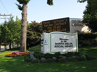
    North Delta is a largely middle-class commuter town situated in the Lower Mainland, of British Columbia, Canada. The community is the most populous of the three communities that make up the City of Delta. North Delta is home to numerous parks and recreational opportunities. Alongside North Delta is Burns Bog, the largest raised urban peat bog in North America. As well, Watershed Park provides walking and biking trails, home to many artesian aquifers. Besides this, North Delta is home to a large amount of green-space. As of the 2016 census, North Delta has a population of 56,017.

    <span class="mw-page-title-main">Gateway Program (Vancouver)</span> Regional transportation project

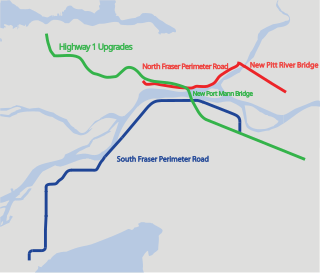
    The Gateway Program is a C$3.0 billion regional transportation project for Metro Vancouver and surrounding areas that is being managed by the British Columbia Ministry of Transportation. The ministry introduced the Gateway Program on January 31, 2006, as a means to address growing congestion and reduce travel times. The bulk of the construction took place from 2006 to 2014 and saw the completion of the Golden Ears Bridge, the Pitt River Bridge, the Port Mann Bridge, improvements on the Sea-to-Sky highway, and finally the construction of the South Fraser Perimeter Road. The Greater Gateway Program is expected to finish by 2030.

    <span class="mw-page-title-main">Tsawwassen ferry terminal</span> Ferry terminal in British Columbia, Canada

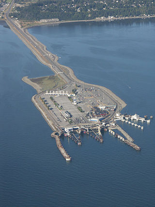
    Tsawwassen Ferry Terminal, as part of the BC Ferries system and of Highway 17, is a major transportation facility in Delta, British Columbia, positioned less than 500 metres (1,600 ft) from the 49th parallel along the Canada–United States border. It is located at the southwestern end of a 3-kilometre (2 mi) artificial causeway that juts out into the Strait of Georgia off the mainland at the community of Tsawwassen. With an approximate size of 23 hectares, it is the largest ferry terminal in North America.

    <span class="mw-page-title-main">Swartz Bay ferry terminal</span> Ferry terminal in British Columbia, Canada

    The Swartz Bay ferry terminal is a 12.1 ha (30-acre) major transportation facility at Swartz Bay in North Saanich, British Columbia. It is located 32 km (20 mi) north of Victoria on Vancouver Island. The terminal is part of the BC Ferries system, as well as part of Highway 17.

    MV <i>Spirit of Vancouver Island</i>

    Spirit of Vancouver Island is an S-class ferry, part of the BC Ferries fleet. Along with MV Spirit of British Columbia, it is the largest in the BC Ferries fleet. The ship was completed in 1994 and serves the Swartz Bay – Tsawwassen route. In 2018, Spirit of Vancouver Island began a mid-life refit in Poland, where it was converted to a dual-fuel system to allow liquefied natural gas propulsion. The vessel returned to service in 2019.

    The 400-series highways were a pair of controlled-access highways located in the southwestern portion of the Canadian province of British Columbia, forming a special subset of the provincial highway system. Modelled after the 400-Series Highways in Ontario, 400-series designations were introduced in 1964 in conjunction with the completion of the Trans-Canada Highway freeway between Vancouver and Clearbrook ; however, unlike their Ontario counterparts, both routes had signalized sections. The 400-series system never expanded beyond two freeways, and in 1973 Highways 401 and 499 were renumbered 1 and 99 respectively, while the former routes were assigned the 'A' suffix.

    <span class="mw-page-title-main">Horseshoe Bay ferry terminal</span> Ferry terminal in British Columbia, Canada

    Horseshoe Bay is a major ferry terminal owned and operated by BC Ferries in British Columbia, Canada. Located in the community of Horseshoe Bay, a neighbourhood of West Vancouver, the terminal provides a vehicle ferry link from the Lower Mainland to Vancouver Island, the Sunshine Coast, and to Bowen Island, a small island in the southern part of Howe Sound.

    <span class="mw-page-title-main">King George Boulevard</span>

    King George Boulevard is a major arterial road in Surrey, British Columbia, Canada. The 26-kilometre (16 mi) route begins at Highway 99, 1.6 kilometres (1.0 mi) north of the Peace Arch Border Crossing with the United States, and runs generally northwest to the south end of the Pattullo Bridge, a crossing of the Fraser River that connects Surrey with New Westminster. The majority of the route varies from four to six lanes, and some sections in the north run parallel to the Expo Line, which has two adjacent SkyTrain stations: Scott Road station in South Westminster, and King George station in the Surrey City Centre district.

    Marine Drive is the name for three major roadways in Greater Vancouver, British Columbia, Canada. The roads are known for running parallel to major bodies of water, with some sections being a major arterial road, while other serve local traffic. Marine Way is the name applied to a section of Marine Drive that was bypassed in the early 1980s.

    References

    1. 1 2 Google (March 17, 2017). "Hwy 17 in Victoria" (Map). Google Maps . Google. Retrieved March 17, 2017.
    2. 1 2 Landmark Kilometre Inventory (PDF). British Columbia Ministry of Transportation and Infrastructure (Report). Cypher Consulting. July 2016. pp. 272–281. Archived from the original (PDF) on March 11, 2017. Retrieved March 18, 2017.
    3. Mindenhall, Dorothy (2012). Unbuilt Victoria. Toronto, ON: Dundurn. p. 156. ISBN   978-1-4597-0176-2.
    4. "Official Numbered Routes in British Columbia - Highway 17". Ministry of Transportation and Infrastructure. Province of British Columbia. Archived from the original on January 5, 2017. Retrieved January 5, 2017.
    5. "Gatewayprogram.bc.ca". Gatewayprogram.bc.ca. Archived from the original on December 20, 2007. Retrieved November 29, 2012.
    6. 1 2 Sinoski, Kelly (November 30, 2012). "First 10 kilometres of new Highway 17 opens Dec. 1". The Vancouver Sun. Retrieved December 29, 2013.
    7. "TH.tranbc.ca". Archived from the original on August 7, 2020. Retrieved July 30, 2019.
    8. "TH.gov.bc.ca". TH.gov.bc.ca. Retrieved November 29, 2012.
    9. "TH.gov.bc.ca" (PDF). Archived from the original (PDF) on February 7, 2012. Retrieved November 29, 2012.
    10. Burnsbog.org Archived July 25, 2008, at the Wayback Machine , Burns Bog Conservation Society " Resources " Sustainable Development Strategy
    11. "Submission to Environmental Assessment Office". Burns Bog Conservation Society. Archived from the original on September 29, 2007.
    12. Burnsbog.org
    13. Burns Bog Conservation Society. "LAWSUIT LAUNCHED OVER ROAD CONSTRUCTION ON BURNS BOG" (PDF). Archived from the original (PDF) on March 31, 2012. Retrieved September 1, 2011.
    14. International Mire Conservation Group. "Threatened Peatlands" . Retrieved May 15, 2013.
    15. Wilderness Committee. "Gateway to Global Warming". Archived from the original on September 29, 2011. Retrieved September 1, 2011.
    16. Dawn, Paley (May 5, 2011). "Camp Closed, But Resistance Continues". Vancouver Media Co-op. Retrieved September 1, 2011.
    17. "South Fraser Perimeter Road, B.C.'s newest highway opens". Province of British Columbia. Archived from the original on December 23, 2013. Retrieved December 22, 2013.
    18. "South Fraser Perimeter Road completed, officially opens today". Canada Newswire. December 21, 2013. Retrieved December 22, 2013.
    19. "Major upgrades announced for Highways 91 and 17". NEWS 1130. March 10, 2017. Retrieved March 13, 2017.
    20. Highway 17 and River Road interchange opens to traffic
    21. "Highway 91/17 Upgrade Project". Province of British Columbia.
    22. "Highway 91/17 upgrades near completion". BC Gov News. Delta, B.C. December 19, 2022. Retrieved December 23, 2022.
    23. "Highway 17 Keating Cross Overpass Project". BC Ministry of Transportation. Retrieved January 2, 2022.
    24. Saltman, Jennifer (March 15, 2018). "Province scaling back Surrey road connections to new Pattullo Bridge". Vancouver Sub.
    25. 1 2 3 "Spring 2020 Project Overview" (PDF). Pattullo Bridge Replacement. Government of British Columbia. pp. 9–10.
    26. "Hwy 91/17 and Deltaport Way - Construction and Traffic Updates". Province of British Columbia. May 28, 2022.
    27. Highway 17 and River Road interchange opens to traffic
    28. HIGHWAY 91 / 17 UPGRADE CONCEPT
    29. "Closure of Elevator Road" (PDF). Port Metro Vancouver. Retrieved October 9, 2020.
    30. "North Surrey truck parking facility construction moving ahead". BC Gov News. Ministry of Transportation and Infrastructure. August 4, 2020.
    Template:Attached KML/British Columbia Highway 17
    KML is from Wikidata