
Vancouver Island is an island in the northeastern Pacific Ocean and part of the Canadian province of British Columbia. The island is 456 km (283 mi) in length, 100 km (62 mi) in width at its widest point, and 32,100 km2 (12,400 sq mi) in total area, while 31,285 km2 (12,079 sq mi) are of land. The island is the largest by area and the most populous along the west coasts of the Americas.

The Trans-Canada Highway is a transcontinental federal–provincial highway system that travels through all ten provinces of Canada, from the Pacific Ocean on the west coast to the Atlantic Ocean on the east coast. The main route spans 7,476 km (4,645 mi) across the country, one of the longest routes of its type in the world. The highway system is recognizable by its distinctive white-on-green maple leaf route markers, although there are small variations in the markers in some provinces.
Highway 4 is the longest east–west main vehicle route on Vancouver Island, British Columbia, Canada, with a total length of 162 km (101 mi). It is known locally as the Alberni Highway to the east of Port Alberni and the Pacific Rim Highway to the west. The original highway from Parksville to Alberni and Port Alberni was completed in 1942 and was originally designated as Highway 1A. It was re-designated as Highway 4 in 1953, and was extended in 1961 to the district of Tofino, on the west coast of the Island.
British Columbia Highway 14, named the West Coast (Sooke) Highway is the southernmost numbered route in the province of British Columbia. An east–west highway on the southwestern coast of Vancouver Island in the Capital Regional District, it is sometimes known as the Juan de Fuca Highway, as well as Sooke Road, Sooke being one of the largest communities that the highway passes through. Highway 14 first opened in 1953, extending west from Colwood, a suburb of Victoria, to the coastal community of Jordan River, and was extended all the way west to the remote community of Port Renfrew by 1975. The highway's eastern terminus was relocated to northern Langford in 2002.
Highway 1 is a provincial highway in British Columbia, Canada, that carries the main route of the Trans-Canada Highway (TCH). The highway is 1,047 kilometres (651 mi) long and connects Vancouver Island, the Greater Vancouver region in the Lower Mainland, and the Interior. It is the westernmost portion of the main TCH to be numbered "Highway 1", which continues through Western Canada and extends to the Manitoba–Ontario boundary. The section of Highway 1 in the Lower Mainland is the second-busiest freeway in Canada, after Ontario Highway 401 in Toronto.
Highway 17 is a provincial highway in British Columbia, Canada. It comprises two separate sections connected by a ferry link. The Vancouver Island section is known as the Patricia Bay Highway and connects Victoria to the Swartz Bay ferry terminal in North Saanich. The Lower Mainland section is known as the South Fraser Perimeter Road and connects the Tsawwassen ferry terminal to Delta and Surrey, terminating at an interchange with Highway 1 in the Fraser Valley.
Highway 99 is a provincial highway in British Columbia that runs 377 kilometres (234 mi) from the U.S. border to near Cache Creek, serving Greater Vancouver and the Squamish–Lillooet corridor. It is a major north–south artery within Vancouver and connects the city to several suburbs as well as the U.S. border, where it continues south as Interstate 5. The central section of the route, also known as the Sea to Sky Highway, serves the communities of Squamish, Whistler, and Pemberton. Highway 99 continues through Lillooet and ends at a junction with Highway 97 near Cache Creek.
There are many roads in the southwestern part of British Columbia and Vancouver Island that were designated as Highway 1A. These roads were sections of the original 1941 route of Highway 1 before its various re-alignments, and are used today as service routes and frontage roads. The "B.C. Highway 1A" designations were removed from these sections by the province between 2005 and 2010, although signage remains along some of the route and the designation on some maps.

The Island Rail Corridor, previously the Esquimalt & Nanaimo Railway, is a dormant railway operation on Vancouver Island and is the only remaining railway there after the closure of the Englewood Railway in November 2017. The Island Corridor Foundation owns the former Esquimalt & Nanaimo Railway corridor. The railway line is 225 kilometres (140 mi) in length from Victoria to Courtenay, known as the Victoria Subdivision, with a branch line from Parksville to Port Alberni known as the Port Alberni Subdivision at 64 kilometres (40 mi) in length, for a total 289 kilometres (180 mi) of mainline track. In 2006, the Island Corridor Foundation acquired the railway's ownership from the Canadian Pacific Railway.

Duncan is a city on southern Vancouver Island in British Columbia, Canada. It is the smallest city by area in Canada. It was incorporated in 1912.

North Cowichan is a district municipality established in 1873 on Vancouver Island, in British Columbia, Canada. The municipality is part of the Cowichan Valley Regional District. North Cowichan is noted for a landscape including forests, beaches, rivers, and lakes. The municipality encompasses the communities of Chemainus; Westholme; Crofton; Maple Bay; and "the South End". The latter is an informal name for a built-up area which is essentially a suburb of the City of Duncan, a separate municipality.
Malahat is an unincorporated area in the Cowichan Valley, with municipal-type services delivered by the Cowichan Valley Regional District. What could be considered the hub of the community is a small collection of businesses that includes the Malahat Gas station and the Malahat Chalet and the Moon Water Lodge.

The British Columbia Coast, popularly referred to as the BC Coast or simply the Coast, is a geographic region of the Canadian province of British Columbia. As the entire western continental coastline of Canada along the Pacific Ocean is in B.C., it is synonymous with being the West Coast of Canada.

Port Renfrew is a small unincorporated community located on the south shore of Port San Juan, an inlet on the west coast of Vancouver Island in British Columbia, Canada. Port Renfrew has a population of 144 and has been touted as "the Tall Tree Capital of Canada".
Mill Bay is a commuter town of about 7,200 people located on Vancouver Island, British Columbia, Canada about 30 km (19 mi) north of Victoria, the capital. It is part of the Cowichan Valley Regional District.

Horseshoe Bay is a major ferry terminal owned and operated by BC Ferries in British Columbia, Canada. Located in the community of Horseshoe Bay, a neighbourhood of West Vancouver, the terminal provides a vehicle ferry link from the Lower Mainland to Vancouver Island, the Sunshine Coast, and to Bowen Island, a small island in the southern part of Howe Sound.

Port San Juan is an inlet along the Pacific coast of Vancouver Island in British Columbia, Canada. It was formed from the San Juan and Leech River faults which flank the northern and southern slopes of the San Juan Valley. The San Juan and Gordon rivers empty into the inlet from the northeast.
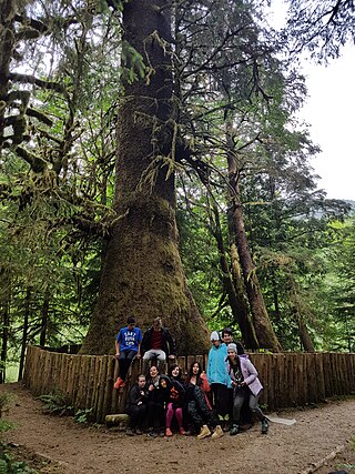
The Harris Creek Sitka Spruce is a large Sitka spruce tree, about 4 metres (13 ft) in diameter, near the creek bed of Harris Creek, off the Pacific Marine Road between Port Renfrew, BC and Honeymoon Bay, BC on Vancouver Island, in British Columbia. Although it is not the largest sitka spruce on Vancouver Island, it is easily accessible and has become a famous tree along the Pacific Marine Loop going from Victoria, BC, through Port Renfrew, Lake Cowichan, and Duncan, BC and returning to Victoria over the Malahat Drive. It is approximately 80 metres (260 ft) tall.
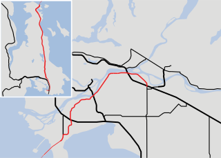
The Pacific Marine Circle Route is a 263-kilometre (163 mi) marked scenic loop road through southern Vancouver Island in British Columbia, Canada. The route is composed of Highway 14, Pacific Marine Road, Shore Road, Highway 18, and a segment of the Trans-Canada Highway.
Lizard Lake is a lake on Vancouver Island, in British Columbia, Canada near the town of Port Renfrew. It is located in the Capital Regional District. The lake is northeast of the junction of Harris Creek and the San Juan River. Lizard Lake lies at an elevation of 65 metres (213 ft) above sea level and has a surface area of 8 hectares. Its mean depth is 15 metres (49 ft) with a maximum of 16 metres (52 ft).
