
The Battle of the Wilderness was fought on May 5–7, 1864, during the American Civil War. It was the first battle of Lieutenant General Ulysses S. Grant's 1864 Virginia Overland Campaign against General Robert E. Lee and the Confederate Army of Northern Virginia. The fighting occurred in a wooded area near Locust Grove, Virginia, about 20 miles (32 km) west of Fredericksburg. Both armies suffered heavy casualties, nearly 29,000 in total, a harbinger of a war of attrition by Grant against Lee's army and, eventually, the Confederate capital, Richmond, Virginia. The battle was tactically inconclusive, as Grant disengaged and continued his offensive.

Spotsylvania County is a county in the U.S. state of Virginia. As of the July 2021 estimate, the population was 143,676. Its county seat is Spotsylvania Courthouse.

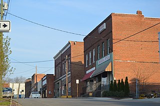
Orange County is a county located in the Central Piedmont region of the Commonwealth of Virginia. At the 2020 census, the population was 36,254. Its county seat is Orange. Orange County includes Montpelier, the 2,700-acre (1,100 ha) estate of James Madison, the 4th President of the United States and often known as the "Father of the Constitution". The county will celebrate its 290th anniversary in 2024.
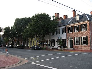
Fredericksburg is an independent city in Virginia, United States. As of the 2020 census, the population was 27,982. It is 48 miles (77 km) south of Washington, D.C., and 53 miles (85 km) north of Richmond. The Bureau of Economic Analysis of the United States Department of Commerce combines the city of Fredericksburg with neighboring Spotsylvania County for statistical purposes.

Fluvanna County is a county located in the Piedmont region of the Commonwealth of Virginia. As of the 2020 census, the population was 27,249. Its county seat is Palmyra, while the most populous community is the census designated place of Lake Monticello.

Caroline County is a United States county located in the eastern part of the Commonwealth of Virginia. The northern boundary of the county borders on the Rappahannock River, notably at the historic town of Port Royal. The Caroline county seat is Bowling Green.
Brookneal is an incorporated town in Campbell County, Virginia, United States. The population was 1,112 as of the 2010 census. It is part of the Lynchburg Metropolitan Statistical Area.

Virginia Railway Express (VRE) is a commuter rail service that connects outlying small cities of Northern Virginia to Union Station in Washington, D.C. It operates two lines which run during weekday rush hour only: the Fredericksburg Line from Spotsylvania, Virginia, and the Manassas Line from Broad Run station in Bristow, Virginia. In 2022, the system had a ridership of 1,172,700, or about 6,200 per weekday as of the first quarter of 2023.

The Orange and Alexandria Railroad (O&A) was a railroad in Virginia, United States. Chartered in 1848, it eventually extended from Alexandria to Gordonsville, with another section from Charlottesville to Lynchburg. The road played a crucial role in the American Civil War, saw the first of many mergers in 1867, and eventually became an important part of the modern-day Norfolk Southern rail system.

Fredericksburg and Spotsylvania National Military Park is a unit of the National Park Service in Fredericksburg, Virginia, and elsewhere in Spotsylvania County, commemorating four major battles in the American Civil War: Fredericksburg, Chancellorsville, The Wilderness, and Spotsylvania.

Locust Grove is an unincorporated community in eastern Orange County, Virginia, United States. Its ZIP code is 22508, the population of the ZIP Code Tabulation Area was 7,605 at the time of the 2000 census and increased by 60% to 12,696 by the 2010 census, making it the largest population center within the county. While Locust Grove has historically been centered on the intersection of State Routes 20 and 611, most of the current population and commercial activity is located along the State Route 3 corridor, several miles to the east. It is named after the Black Locust trees common to the area.

State Route 2, formerly State Route 50, is a primary state highway in the U.S. state of Virginia. The state highway runs 53.08 miles (85.42 km) from U.S. Route 1 and US 301 in Richmond north to US 1 Business, US 17 Business, and SR 3 Business in Fredericksburg. SR 2 connects Richmond and Fredericksburg via Bowling Green. The state highway runs concurrently with US 301 from Richmond to Bowling Green and with US 17 Business in the Fredericksburg area.

State Route 20 is a primary state highway in the U.S. state of Virginia. The state highway runs 89.79 miles (144.50 km) from U.S. Route 15 in Dillwyn north to SR 3 in Wilderness. SR 20 is a C-shaped route that connects Charlottesville with Farmville in Southside Virginia. The state highway also links Charlottesville to Fredericksburg by way of Orange County, within which SR 20 is the main east–west highway and intersects US 15 again in the county seat of Orange.
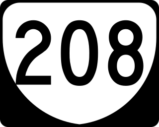
State Route 208 is a primary state highway in the U.S. state of Virginia. The state highway runs 47.35 miles (76.20 km) from U.S. Route 250 at Ferncliff east to US 1 and US 1 Business at Four Mile Fork. SR 208 is a major southwest–northeast highway through Louisa and Spotsylvania counties. The state highway connects the counties' respective seats of Louisa and Spotsylvania Courthouse, where the old route of the highway is SR 208 Business, with each other and with Fredericksburg near the highway's eastern terminus. SR 208 also has a direct connection with Interstate 64 (I-64) at Ferncliff and an indirect connection to I-95 near Fredericksburg.
Spotsylvania County Public Schools is a public school district serving Spotsylvania County, Virginia. It consists of 17 Elementary, 7 Middle, and 5 High Schools and has a total enrollment of nearly 24,000 students. The Spotsylvania County School division also has a Career and Technical Center and participates with other local school systems to offer the Commonwealth Governor's School. The district partners with area businesses to develop learning opportunities for the students. Spotsylvania County Public Schools works with the area Parks and Recreation Department to help maintain the area around the Schools.

The Fredericksburg Line is a commuter rail line operated by Virginia Railway Express between Washington, D.C., and Fredericksburg, Virginia. Virginia Railway Express operates 8 weekday trains, and Amtrak trains serve a few of the stations on the line. Trackage is owned by CSX as part of their RF&P Subdivision.
Todds Tavern is an unincorporated community in Spotsylvania County, Virginia, United States, and was the site of the Battle of Todd's Tavern.

Chancellor is an unincorporated community in Spotsylvania County, in the U.S. state of Virginia. Originally named Screamersville, the community was established as a railroad whistle stop west of Fredericksburg. The name was changed to Chancellor around 1927 by agreement of the railroad and the local community.

The Potomac, Fredericksburg, and Piedmont Railroad (PF&P) was a 3 ft narrow gauge short-line railroad in central Virginia that operated between Fredericksburg and Orange, Virginia. It operated until 1926, when its track was sold. A one-mile portion of the former PF&P line continued to be operated as the Virginia Central Railway until the early 1980s. The track has since been removed.


