The Clatskanie River is a tributary of the Columbia River, approximately 25 miles (40 km) long, in northwestern Oregon in the United States. It drains a timber-producing area in the foothills of the Northern Oregon Coast Range north-northwest of Portland.

Governor Tom McCall Waterfront Park is a 36.59-acre (148,100 m2) park located in downtown Portland, Oregon, along the Willamette River. After the 1974 removal of Harbor Drive, a major milestone in the freeway removal movement, the park was opened to the public in 1978. The park covers 13 tax lots and is owned by the City of Portland. The park was renamed in 1984 to honor Tom McCall, the Oregon governor who pledged his support for the beautification of the west bank of the Willamette River—harkening back to the City Beautiful plans at the turn of the century which envisioned parks and greenways along the river. The park is bordered by RiverPlace to the south, the Steel Bridge to the north, Naito Parkway to the west, and Willamette River to the east. In October 2012, Waterfront Park was voted one of America's ten greatest public spaces by the American Planning Association.

The Multnomah Channel is a 21.5-mile (34.6 km) distributary of the Willamette River. It diverges from the main stem a few miles upstream of the main stem's confluence with the Columbia River in Multnomah County in the U.S. state of Oregon. The channel flows northwest then north around Sauvie Island to meet the Columbia River near the city of St. Helens, in Columbia County.

Goshen is an unincorporated community in Lane County, Oregon, United States. It is located at the junction of Oregon Route 58, Oregon Route 99, and Interstate 5.
Bridgeton is a compact neighborhood of detached houses, rowhouses, apartment and condominium complexes, and houseboats in the north and northeast sections of Portland, Oregon. It occupies a narrow strip of land around a levee between the Columbia River and Bridgeton Slough.

Charleston is an unincorporated community in Coos County, Oregon, United States. Charleston is the least populated community in Oregon's Bay Area and is Home to a large commercial fishing fleet, it is adjacent to the ocean entrance to Coos Bay. Charleston is the site of the Oregon Institute of Marine Biology and the United States Coast Guard Charleston Lifeboat Station.

Agate Beach is an unincorporated community in Lincoln County, Oregon, United States. Agate Beach is named for the agates that are found on the beaches of the Pacific Ocean between Newport and Yaquina Head. Agate Beach post office was established in 1912 and closed in 1971.
Triangle Lake is an unincorporated community in Lane County, Oregon, United States. It is about 25 miles (40 km) west of Junction City on Oregon Route 36, on the southwest side of the lake of same name. Lake Creek, a tributary of the Siuslaw River, enters and exits the lake. Triangle Lake is closely linked to the unincorporated community of Blachly, on the northeast side of the lake, and the two communities share the K-12 Triangle Lake School, the only school in Blachly School District. Triangle Lake is served by the Blachly post office and the Pioneer Telephone Cooperative.
Shedd is an unincorporated community and census-designated place (CDP) in Linn County, Oregon, United States, on Oregon Route 99E. As of the 2010 census it had a population of 204.

Odell Lake is located near Willamette Pass in the northwest corner of Klamath County, Oregon, United States. It is one of several lakes in the Cascade Range in Central Oregon, and lies within the Deschutes National Forest. It was named for Oregon Surveyor General William Holman Odell by Bynon J. Pengra, in July 1865, while they were making a preliminary survey for the Oregon Central Military Road, which would later become Oregon Route 58. The lake fills a basin carved by a glacier, and the resulting terminal moraine confines the water along the lake's southeast shore.

Kelley Point Park is a city park in north Portland in the U.S. state of Oregon. Bounded by the Columbia Slough on the south, the Willamette River on the west, and the Columbia River on the north, the park forms the tip of the peninsula at the confluence of the rivers. Marine Terminal 6 of the Port of Portland lies immediately east of the park along the Columbia, while Terminal 5 is along the Willamette slightly south of the Columbia Slough. The park is at 45.6498384°N 122.7637106°W and rises to an elevation of 39 feet (12 m) above sea level. Sauvie Island is west of the park across the Willamette River. Hayden Island is slightly upstream of the park on the Columbia River opposite Marine Terminal 6.

Cazadero is an unincorporated historic locale in Clackamas County, Oregon, United States. Cazadero was a station on the Estacada interurban railway line of the Portland Railway, Light and Power Company (PRL&P) and later Portland Electric Power Company (PEPCO), near where the power plant of the PEPCO-owned Cazadero Dam was located on the Clackamas River.
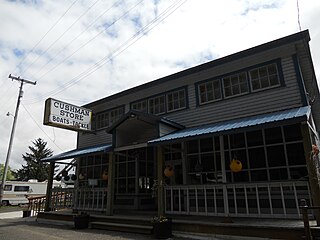
Cushman is an unincorporated community in Lane County, Oregon, United States. It is located on the north bank of the Siuslaw River on Oregon Route 126, between Tiernan and Florence.
Libby, previously known as Easport, is an unincorporated community on Coalbank Slough in Coos County, Oregon, United States. It was named for a Native American woman. Its post office was established on June 11, 1890, and operated for just two years. Enoch Gore was postmaster.
Woodson is an unincorporated community in Columbia County, Oregon, United States. It is located on U.S. Route 30 seven miles west of Clatskanie and three miles east of Westport, on Westport Slough, a tributary of the Columbia River. In December 2007, the debris overflow from the flooding of Eilersten Creek caused evacuations and mud cover on Woodson Road north of the highway.

Hauser is an unincorporated community in Coos County, Oregon, United States. It is along U.S. Route 101, 7 miles (11 km) south of Lakeside and 6 miles (10 km) north of North Bend. Hauser is on the edge of the Oregon Dunes National Recreation Area near North Slough, a tributary of Coos Bay once known as the North Inlet of Coos Bay. It is a station on the Central Oregon and Pacific Railroad.
Crowley is an unincorporated community in Polk County, Oregon, United States. It is located east of Oregon Route 99W, about four miles north of Rickreall.
Derry is an unincorporated locale in Polk County, Oregon, United States. It is located about 10 miles west of Salem and one mile east of Rickreall.
Burlington is an unincorporated historic community Linn County, in the U.S. state of Oregon. It was located about a mile downriver from Peoria.

James Clinton was a steamboat which operated on the upper Willamette River from 1856 to 1861. Although the Clinton was said to have been "not a very good boat.", it was the first steamer ever to reach Eugene, Oregon. James Clinton was destroyed in April 1861, when a large fire broke out at Linn City, Oregon in a shoreside structure near to where the vessel was moored.