Warrenton, Oregon

Last updated

Warrenton, Oregon
Warrenton Marina (Clatsop County, Oregon scenic images) (clatDA0042a).jpg
Warrenton marina
Motto: 
"Making a Difference through excellence of service"
Clatsop County Oregon Incorporated and Unincorporated areas Warrenton Highlighted.svg
Location in Oregon
Coordinates: 46°9′54″N123°55′27″W / 46.16500°N 123.92417°W / 46.16500; -123.92417
Country United States
State Oregon
County Clatsop
Incorporated 1899
Government
   Mayor Henry Balensifer
Area
[1]
  Total17.03 sq mi (44.11 km2)
  Land12.66 sq mi (32.78 km2)
  Water4.37 sq mi (11.33 km2)
Elevation
8 ft (2.4 m)
Population
 (2020) [2]
  Total6,277
  Density495.93/sq mi (191.49/km2)
Time zone UTC−08:00 (Pacific)
  Summer (DST) UTC−07:00 (Pacific)
ZIP code
97146
Area code(s) 503 and 971
FIPS code 41-78900 [3]
GNIS feature ID1136879 [4]
Website www.ci.warrenton.or.us

Warrenton is a small, coastal city in Clatsop County, Oregon, United States. Named for D.K. (Daniel Knight) Warren, an early settler, the town is primarily a fishing and logging community. The population was 6,277 according to the 2020 US Census. Warrenton is a less urbanized area close to the Clatsop County seat, Astoria.

Contents

History

The historic D.K. Warren House (built 1885) on NE Skipanon Dr. Warren House - Warrenton Oregon.jpg
The historic D.K. Warren House (built 1885) on NE Skipanon Dr.

Prior to the arrival of the first settlers, this land was inhabited by the Clatsop tribe of Native Americans, whose tribe spanned from the south shore of the Columbia River to Tillamook Head. The county in which Warrenton is located was named after these people, as well as the last encampment that the Lewis and Clark Expedition established. Today, a replica of Fort Clatsop still stands just outside of Warrenton city limits.

The first pioneers who settled on the land that would become Warrenton (between 1845 and the early 1850s) were Jeremiah Gerome Tuller, J. W. Wallace, D. E. Pease, Ninian A. Eberman and George Washington Coffenbury. Coffenbury remains a household name in the town, as a local lake in Fort Stevens was named after him.

The first settlement within Warrenton city limits was Lexington, which was laid out in 1848, and served as the first county seat for Clatsop County. The name fell out of use for a time, and the area became known as Skipanon – a name that is now preserved by the Skipanon River, which flows through the town. A Lexington post office operated intermittently between 1850 and 1857; a Skipanon post office operated continuously from 1871 to 1903.

In 1863, the military battery, Fort Stevens, was built in the Warrenton area near the mouth of the Columbia River. Though military activity ceased in 1947, the remains of the fort are preserved as part of Fort Stevens.

Very few improvements were made to the land until the early 1870s, when D. K. Warren bought out some of the first settlers. With the help of Chinese labor, Warren reclaimed a large tract of the land by constructing a dike about 2.5 miles (4.0 km) in length, which was completed in 1878. Warren laid out the town in about 1891, and in the following year built the first schoolhouse, at a cost of $1,100, and gave it to the school district. [5]

Warrenton was platted in 1889 and incorporated as a city in 1899. Built on tidal flats, it relied on a system of dikes built by Chinese laborers to keep the Columbia River from flooding the town.

Geography

Standing at the northwestern extreme of Oregon, Warrenton is about 5 miles (8.0 km) west of Astoria, across the Youngs Bay bridge, which spans over 4,200 feet (1,300 m) of the Youngs Bay estuary at the mouth of the Columbia River.

According to the United States Census Bureau, the city has a total area of 17.66 square miles (45.74 km2), 12.77 square miles (33.07 km2) of which is land and 4.89 square miles (12.67 km2) is water. [6]

Warrenton has one charter fishing port in Hammond and a major commercial fishing port in downtown Warrenton.

Community

Warrenton is made up of the previously individual communities of Flavel, Fort Stevens, Hammond, Lexington, and Skipanon. [7] The Fort Stevens post office operated at the Fort Stevens military post from 1899 to 1949. [7] Hammond voted to disincorporate in November 1991 and merged with Warrenton on December 5. [7] Hammond was named for lumberman Andrew B. Hammond, who completed the Astoria and Columbia River Railroad. [8] Hammond, originally the site of a Clatsop village called Ne-ahk-stow, [8] has its own ZIP Code of 97121, but is now technically part of Warrenton.

Climate

This region experiences mildly warm and dry summers, with no average monthly temperatures above 71.6 °F (22.0 °C). It's typically overcast or rainy due to its proximity to the ocean, but it does have some sunshine. According to the Köppen Climate Classification system, Warrenton has a warm-summer Mediterranean climate, abbreviated "Csb" on climate maps. [9]

Demographics

Historical population
CensusPop.Note
1900 332
1910 3392.1%
1920 730115.3%
1930 683−6.4%
1940 1,36599.9%
1950 1,89638.9%
1960 1,717−9.4%
1970 1,8256.3%
1980 2,49336.6%
1990 2,6817.5%
2000 4,09652.8%
2010 4,98921.8%
2020 6,27725.8%
source: [10] [11] [2]

2020 census

As of the 2020 census, [12] the population was 6,277. There were 2,715 housing units, of which 2,497 were occupied and 218 were vacant. The racial makeup of the city was 82.1% White, 0.6% African American, 1.2% Native American, 1.6% Asian, 0.4% Pacific Islander, 4.1% from other races, and 10% from two or more races. Hispanic or Latino of any race were 9.1% of the population. 22.9% of residents were under the age of 18.

2010 census

As of the census [13] of 2010, there were 4,989 people, 1,948 households, and 1,287 families residing in the city. The population density was 390.7 inhabitants per square mile (150.9/km2). There were 2,196 housing units at an average density of 172.0 per square mile (66.4/km2). The racial makeup of the city was 91.5% White, 0.6% African American, 1.3% Native American, 1.1% Asian, 0.7% Pacific Islander, 1.8% from other races, and 3.0% from two or more races. Hispanic or Latino of any race were 5.7% of the population.

There were 1,948 households, of which 31.3% had children under the age of 18 living with them, 48.5% were married couples living together, 11.7% had a female householder with no husband present, 5.9% had a male householder with no wife present, and 33.9% were non-families. 26.4% of all households were made up of individuals, and 10% had someone living alone who was 65 years of age or older. The average household size was 2.45 and the average family size was 2.95.

The median age in the city was 37.6 years. 23.8% of residents were under the age of 18; 9.8% were between the ages of 18 and 24; 25.2% were from 25 to 44; 27.4% were from 45 to 64; and 14% were 65 years of age or older. The gender makeup of the city was 51.0% male and 49.0% female.

2000 census

At the 2000 census, [3] there were 4,096 people, 1,621 households and 1,087 families residing in the city. The population density was 332.2 inhabitants per square mile (128.3/km2). There were 1,799 housing units at an average density of 145.9 per square mile (56.3/km2). The racial makeup of the city was 92.53% White, 0.22% African American, 1.32% Native American, 1.76% Asian, 0.07% Pacific Islander, 1.27% from other races, and 2.83% from two or more races. Hispanic or Latino of any race were 2.91% of the population. 15.4% were of American, 12.1% German, 9.2% English, 8.9% Irish and 8.1% Norwegian ancestry according to Census 2000.

There were 1,621 households, of which 33.7% had children under the age of 18 living with them, 52.1% were married couples living together, 11.0% had a female householder with no husband present, and 32.9% were non-families. 26.5% of all households were made up of individuals, and 10.2% had someone living alone who was 65 years of age or older. The average household size was 2.49 and the average family size was 3.00.

Age distribution was 26.6% under the age of 18, 8.2% from 18 to 24, 29.8% from 25 to 44, 22.4% from 45 to 64, and 13.1% who were 65 years of age or older. The median age was 37 years. For every 100 females, there were 103.0 males. For every 100 females age 18 and over, there were 100.3 males.

The median household income was $33,472, and the median family income was $42,946. Males had a median income of $31,654 versus $21,133 for females. The per capita income for the city was $16,874. About 11.9% of families and 14.2% of the population were below the poverty line, including 19.4% of those under age 18 and 11.7% of those age 65 or over.

Education

Warrenton High School is a small school with a total enrollment of between 300 and 400. Warrenton Grade School is a K-8 school with a total enrollment of about 700 students.

Notable people

See also

Related Research Articles

<span class="mw-page-title-main">Washington County, Oregon</span> County in Oregon, United States

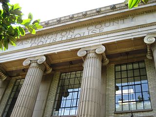
Washington County is one of 36 counties in the U.S. state of Oregon and part of the Portland metropolitan area. The 2020 census recorded the population as 600,372, making it the second most populous county in the state and most populous "Washington County" in the United States. Hillsboro is the county seat and largest city, while other major cities include Beaverton, Tigard, Cornelius, Banks, Gaston, Sherwood, North Plains, and Forest Grove, the county's oldest city. Originally named Twality when created in 1843, the Oregon Territorial Legislature renamed it for the nation's first president in 1849 and included the entire northwest corner of Oregon before new counties were created in 1854. The Tualatin River and its drainage basin lie almost entirely within the county, which shares its boundaries with the Tualatin Valley. It is bordered on the west and north by the Northern Oregon Coast Range, on the south by the Chehalem Mountains, and on the north and east by the Tualatin Mountains, or West Hills.

<span class="mw-page-title-main">Wahkiakum County, Washington</span> County in Washington, United States

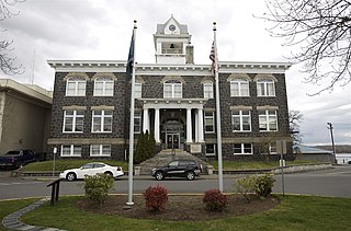
Wahkiakum County is a county located in the U.S. state of Washington. As of the 2020 census, the population was 4,422, making it one of least populous counties in Washington. The county seat and only incorporated town is Cathlamet. The county was formed out of Cowlitz County in April 1854 and is named for Chief Wahkiakum of the Chinook, who is buried in the Pioneer Cemetery in Cathlamet.

<span class="mw-page-title-main">Pacific County, Washington</span> County in Washington, United States

Pacific County is a county in the U.S. state of Washington. As of the 2020 census, the population was 23,365. Its county seat is South Bend, and its largest city is Raymond. The county was formed by the government of Oregon Territory in February 1851 and is named for the Pacific Ocean.

<span class="mw-page-title-main">Columbia County, Oregon</span> County in Oregon, United States

Columbia County is one of the 36 counties in the U.S. state of Oregon. As of the 2020 census, the population was 52,589. The county seat is St. Helens.

<span class="mw-page-title-main">Clatsop County, Oregon</span> County in Oregon, United States

Clatsop County is one of the 36 counties in the U.S. state of Oregon. As of the 2020 census, the population was 41,072. The county seat is Astoria. The county is named for the Clatsop tribe of Native Americans, who lived along the coast of the Pacific Ocean prior to European settlement. Clatsop County comprises the Astoria, OR Micropolitan Statistical Area, or Sunset Empire, and is located in Northwest Oregon.

<span class="mw-page-title-main">Warren County, Missouri</span> County in Missouri, United States

Warren County is a county located in the eastern portion of the U.S. state of Missouri. As of the 2020 census, the population was 35,532. The county is located on the north side of the Missouri River. Its county seat is Warrenton. The county was established on January 5, 1833, and was named for General Joseph Warren, who died in the Battle of Bunker Hill during the American Revolutionary War.

<span class="mw-page-title-main">Warren County, Georgia</span> County in Georgia, United States

Warren County is a county located in the U.S. state of Georgia. As of the 2020 United States census, the population was 5,215, a decrease from 2010. The county seat is Warrenton. The county was created on December 19, 1793, and is named after General Joseph Warren, who was killed in the Battle of Bunker Hill.

<span class="mw-page-title-main">Warrenton, Georgia</span> City in Georgia, United States

Warrenton is a city in Warren County, Georgia, United States. The population was 1,937 at the 2010 census. The city is the county seat of Warren County.

<span class="mw-page-title-main">Hammond, Minnesota</span> City in Minnesota, United States

Hammond is a city in Wabasha County, Minnesota, United States. The population was 132 at the 2010 census.

<span class="mw-page-title-main">Truesdale, Missouri</span> City in Missouri, United States

Truesdale is a city in Warren County, Missouri, United States. It is directly adjacent to the east of Warrenton and is part of the St. Louis MSA. The population was 732 according to the 2010 Census.

<span class="mw-page-title-main">Warrenton, Missouri</span> City in Missouri, United States

Warrenton is a city in Warren County, Missouri, United States. The population was 7,880 according to the 2010 Census. It is the county seat of Warren County. Warrenton is an exurb of St. Louis, and is located in the St. Louis Metropolitan Statistical Area. Warrenton's slogan is "A City for All Seasons."

<span class="mw-page-title-main">Cannon Beach, Oregon</span> City in Oregon, United States

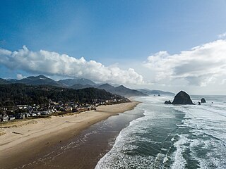
Cannon Beach is a city in Clatsop County, Oregon, United States. Its population was 1,690 at the 2010 census. It is a popular coastal Oregon tourist destination, famous for Haystack Rock, a 235 ft (72 m) sea stack that juts out along the coast. In 2013, National Geographic listed it as "one of the world's 100 most beautiful places."

<span class="mw-page-title-main">Gearhart, Oregon</span> City in Oregon, United States

Gearhart is a city in Clatsop County, Oregon, United States. The population was 1,462 at the 2010 census.

<span class="mw-page-title-main">Clatskanie, Oregon</span> City in Oregon, United States

Clatskanie is a city in Columbia County, Oregon, United States. It was named for the Tlatskanai Native American tribe, and the Clatskanie River which flows through the town and empties into the Columbia River about four miles to the north. The population was 1,737 at the 2010 Census.

<span class="mw-page-title-main">Columbia City, Oregon</span> City in Oregon, United States

Columbia City is a city in Columbia County, Oregon, United States. It was named for its location on the Columbia River. The population was 1,946 at the 2010 census.

<span class="mw-page-title-main">Troutdale, Oregon</span> City in Oregon, United States

Troutdale is a city in Multnomah County, Oregon, United States, immediately north of Gresham and east of Wood Village. As of the 2020 census, the city population was 16,300. The city serves as the western gateway to the Historic Columbia River Highway, the Mount Hood Scenic Byway, and the Columbia River Gorge. It is approximately 12 miles (19 km) east of Portland.

<span class="mw-page-title-main">Echo, Oregon</span> City in Oregon, United States

Echo is a city in Umatilla County, Oregon, United States. The population was 699 at the 2010 census. It is part of the Pendleton–Hermiston Micropolitan Statistical Area.

<span class="mw-page-title-main">Mosier, Oregon</span> City in Oregon, United States

Mosier is a city along the Columbia River in Wasco County, Oregon, United States. The population was 433 at the 2010 census.

<span class="mw-page-title-main">Colville, Washington</span> City in Washington, United States

Colville is a city in Stevens County, Washington, United States. The population was 4,673 at the 2010 census. It is the county seat of Stevens County.

<span class="mw-page-title-main">Kettle Falls, Washington</span> City in Washington, United States

Kettle Falls is a city in Stevens County, Washington, United States, named for the nearby Kettle Falls on the Kettle River. The city itself is located on the Colville River immediately upstream from its confluence with the Columbia River. The population of the city was 1,595 at the time of the 2010 census, a 4.5% increase over the 2000 census.

References

  1. "ArcGIS REST Services Directory". United States Census Bureau. Retrieved October 12, 2022.
  2. 1 2 "Census Population API". United States Census Bureau. Retrieved October 12, 2022.
  3. 1 2 "U.S. Census website". United States Census Bureau . Retrieved January 31, 2008.
  4. "US Board on Geographic Names". United States Geological Survey. October 25, 2007. Retrieved January 31, 2008.
  5. History of the Columbia River Valley From The Dalles to the Sea, Vol. III. The S. J. Clarke Publishing Company. 1928. pp. 526–532.
  6. "US Gazetteer files 2010". United States Census Bureau . Retrieved December 21, 2012.
  7. 1 2 3 McArthur, Lewis A.; McArthur, Lewis L. (2003) [1928]. Oregon Geographic Names (7th ed.). Portland, Oregon: Oregon Historical Society Press. pp. 373, 440. ISBN   978-0875952772.
  8. 1 2 "Hammond" . Retrieved June 1, 2016.
  9. "Warrenton, Oregon Köppen Climate Classification (Weatherbase)" . Retrieved June 1, 2016.
  10. "Warrenton, Oregon". United States Census Bureau . U.S. Census Bureau. Retrieved June 14, 2013.
  11. Moffatt, Riley Moore (1996). Population History of Western U.S. Cities and Towns, 1850–1990. Lanham, Maryland: Scarecrow Press. p. 217. ISBN   978-0-8108-3033-2.
  12. "Warrenton city, Oregon Census Results". data.census.gov. Retrieved February 17, 2022.
  13. "U.S. Census website". United States Census Bureau . Retrieved December 21, 2012.