
Marys River is a 40-mile (64 km) tributary of the Willamette River in the U.S. state of Oregon. From its source at the confluence of its east and west forks near Summit, it flows generally southeast from the Central Oregon Coast Range to Corvallis.
The Wallooskee River is a tributary of the Youngs River, about 10 miles (16 km) long, in northwest Oregon in the United States. It drains a small area of the foothills of the Coast Range near the mouth of the Columbia River. The Youngs River is a tributary of the Columbia River.

The John Day River is a tributary of the Columbia River, approximately 6 miles (10 km) long, in northwestern Oregon in the United States. The river rises in the Northern Oregon Coast Range in Clatsop County at 46.138889°N 123.704722°W.
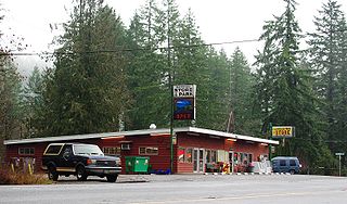
Valsetz was an unincorporated community and timber company town in Polk County, Oregon, United States, west of Falls City in the Central Oregon Coast Range. It no longer exists.

Bull Run is an unincorporated community in Clackamas County, Oregon, United States. It is located about 5 miles (8.0 km) northeast of Sandy, near the Bull Run River and the powerhouse of the defunct Mount Hood Railway and Power Company.
Buena Vista is an unincorporated community in Polk County, Oregon, United States. It is located on the Willamette River, and is the western landing for the Buena Vista Ferry. It is approximately 7 miles (11 km) south-southeast of Independence.

Fort Umpqua was a trading post built by the Hudson's Bay Company in the company's Columbia District, in what is now the U.S. state of Oregon. It was first established in 1832 and moved and rebuilt in 1836.
Glenwood is an unincorporated community in Washington County, Oregon, United States, northwest of Forest Grove on Oregon Route 6.

Horton is an unincorporated community in Lane County, Oregon, United States. It is about three miles northeast of Blachly, in the Lake Creek valley of the Central Oregon Coast Range.
Wonder is an unincorporated community in Josephine County, Oregon, United States, on U.S. Route 199 about 13 miles west of Grants Pass and 8 miles east of Selma. It is within the Rogue River – Siskiyou National Forest.

Quincy is an unincorporated community in Columbia County, Oregon, United States. It is located about 4.5 miles northeast of Clatskanie and 3.5 miles southwest of Mayger in a drained and diked area of the Columbia River lowlands.
Walker is an unincorporated community in Lane County, Oregon, United States. It is located about 4 miles (6 km) north of Cottage Grove on Oregon Route 99, near the Coast Fork Willamette River.
Burnt Woods is an unincorporated community in Lincoln County, Oregon, United States. It is located about 16 miles (26 km) west of Philomath on U.S. Route 20 in the Central Oregon Coast Range near the Tumtum River.
Hamlet is an unincorporated community in Clatsop County, Oregon, United States. It is located approximately six miles southeast of Necanicum, in the Northern Oregon Coast Range near the confluence of the North Fork Nehalem River and the Little North Fork Nehalem River. It is surrounded by units of the Clatsop State Forest.
Holland is an unincorporated community in Josephine County, Oregon, United States. It is about eight miles southeast of Cave Junction, in the Illinois Valley south of Oregon Route 46.
Peel is an unincorporated community in Douglas County, Oregon, United States. It is located about six miles southeast of Glide near the Little River.
Clifton is an unincorporated community in Clatsop County, Oregon, United States. It is located north of U.S. Route 30, about nine miles northwest of Westport on the south bank of the Columbia River. It is on Clifton Channel across from Tenasillahe Island.
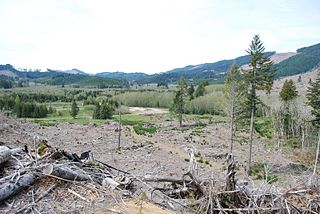
Black Rock is an unincorporated community and former logging camp in Polk County, Oregon, United States. It is located about three miles west of Falls City, in the Central Oregon Coast Range on the Little Luckiamute River.
Suver is an unincorporated community in Polk County, Oregon, United States. It is located about 10 miles north of Corvallis and about 8 miles south of Monmouth, 1 mile east of Oregon Route 99W.
Burlington is an unincorporated historic community Linn County, in the U.S. state of Oregon. It was located about a mile downriver from Peoria.

