This article needs additional citations for verification .(March 2011) |
Campbell Village is a small village in Dominica. It is located in the parish of Saint. Paul, near Mahaut Village and is notable for its hidden waterfalls. [1]
This article needs additional citations for verification .(March 2011) |
Campbell Village is a small village in Dominica. It is located in the parish of Saint. Paul, near Mahaut Village and is notable for its hidden waterfalls. [1]
For the definition of town, village, etc see Settlements in Dominica. | |
| Towns |
|
| Villages |
|
Coordinates: 15°22′30″N61°22′20″W / 15.37500°N 61.37222°W
| | This Dominica location article is a stub. You can help Wikipedia by expanding it. |

The House of Assembly is the legislature of Dominica. It is established by Chapter III of the Constitution of Dominica, and together with the President of Dominica constitutes Dominica's Parliament. The House is unicameral, and consists of twenty-one Representatives, nine senators, and the Attorney General as an ex officio member. The Speaker of the House becomes the thirty-second member if chosen from outside the membership of the House.
La Plaine is a village located on the eastern side of the island of Dominica. It has a population of 1,288, and is the second-largest settlement in Saint Patrick Parish.

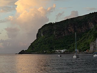
Scotts Head is a village on the southwest coast of Dominica, in Saint Mark Parish. In 2001, its population was 721. Predominantly a fishing village, Scotts Head overlooks Soufrière Bay, which is protected as the Soufrière Scotts Head Marine Reserve. It is also a popular snorkeling and diving site for tourists.

Mahaut is a village on the west coast of Dominica. It has a population of 2,399, and was home to Dominica Colgate-Palmolive until the factory was closed in 2015 after Hurricane Erica.
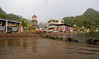
Soufrière is a village on the southwest coast of Dominica. It is the capital of Saint Mark Parish and has a population of 1,416 people.

Hampstead is a village in northeastern Dominica. Along with Bense, the area has a population of 495, and was used as a filming location for 2006's Pirates of the Caribbean: Dead Man's Chest.
Wotten Waven is a village in Dominica's Roseau Valley. It has a population of 226 people.

Castle Bruce is a village on the east coast of Dominica. It is the largest settlement in St. David Parish, with a population of 1,339.
Petite Savanne was a village on the southeast side of Dominica. It had an estimated population of 1,200 in 2015. The region the town was built on features some of Dominica's steepest terrain; the slopes were composed largely of silt and clay.
Canefield is a town located on the west coast of Dominica, north of Roseau and south of Massacre, overlooking Pringle's Bay. The largest settlement in St. Paul Parish, it has a population of 2,803. It is home to an industrial estate with Harris Paints Dominica Ltd., a branch of the Jehovah's Witnesses, as well as the island's second airport. Neighbouring locales include Cochrane, Checkhall, Massacre and Fond Colé.
Paix Bouche is a village in northern Dominica. It has a population of 306, and has one of the island's steepest roads. The name comes from the local Creole expression meaning "shut your mouth".

Pointe Michel is a small town on the southwest coast of Dominica. It is located to the south of the capital, Roseau, and is known for being the birthplace of Dominica's first female Prime Minister, Dame Eugenia Charles.
Rosalie is a village in Dominica. It is located in Saint David Parish at the northern end of Rosalie Bay, on the central east coast of the island, close to the mouth of the Rosalie River.

Massacre is a town in Saint Paul Parish, Dominica, with about 1,200 inhabitants. It is located on the central west coast of the island, to the north of the capital, Roseau, on the Massacre River.
Pont Cassé is situated in the Saint Paul Parish in Dominica. It is located almost in the middle of Dominica, close to Belles Village northeast of the national capital, Roseau, and close to Morne Trois Pitons, the mountain which dominates the southern center of the country. As of 2006 it has a population of 100.
The Coulibistrie River is a river on the Caribbean island of Dominica. It flows from the interior westward through a deep valley, and empties into the Caribbean Sea north of Batalie Bay. It is fast-flowing, with small rapids and numerous bathing pools.
Petit Soufrière is a small village on the east coast of Dominica, upland from Petite Soufrière Bay in Saint David Parish. Located on the steep, rugged slopes of Morne Aux Delices at the end of the main road south from Castle Bruce, it is one of the most isolated villages in Dominica. The village immediately to its north is Saint Sauveur; to its south, though connected only by a hiking trail, is Rosalie.
Coulibistrie is a village on the west coast of Dominica, in the northwest corner of Saint Joseph Parish. It is between the villages of Colihaut to the north and Morne Rachette to the south. It extends inland from the coast within a deep valley, along both banks of the Coulibistrie River. The village is primarily residential with few businesses. Many of the houses are built directly atop or adjoining the numerous large boulders that litter the valley along its base.

Morne Rachette or Morne Raquette is a village on the west coast of Dominica, in the northwest corner of Saint Joseph Parish. It is located on the slopes of Morne Jalousie, above Coulibistrie to its immediate north and Batalie Bay. The village of Salisbury is south of Morne Rachette.
Belles is a small village in the Caribbean island nation of Dominica. It is located at 15°27′12.7″N61°19′11.4″W and is a part of the country's St. Joseph administrative division. Its population is 500. Belles is a historical site for a few reasons. It is a major part of the highway system to the northern part of the island. The roads were blocked many years ago by Rastafarians who were not happy with the government. Many of them escaped to Jaco Flats and used it for refuge. This is a site that was used by the Maroons hundreds of years ago. As of 2016, the Esprit and Benjamin families own and control a majority of the private land.