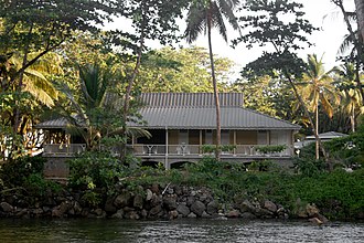
Rosalie is a village in Dominica. [1] It is located in Saint David Parish at the northern end of Rosalie Bay, on the central east coast of the island, close to the mouth of the Rosalie River. [2]
Rosalie is a village in Dominica. [1] It is located in Saint David Parish at the northern end of Rosalie Bay, on the central east coast of the island, close to the mouth of the Rosalie River. [2]

Cabrits National Park is on a peninsula at the north end of the Caribbean island of Dominica, north of Portsmouth. The park protects tropical forest, coral reefs and wetlands. There are hiking trails and an English garrison called Fort Shirley. Cabrits National Park occupies 1,313 acres and was established in 1986.
La Plaine is a village located on the eastern side of the island of Dominica. It has a population of 1,288, and is the second-largest settlement in Saint Patrick Parish.

Mahaut is a village on the west coast of Dominica. It has a population of 2,399, and was home to Dominica Colgate-Palmolive until the factory was closed in 2015 after Hurricane Erica.

Canefield is a town located on the west coast of Dominica, north of Roseau and south of Massacre, overlooking Pringle's Bay. The largest settlement in St. Paul Parish, it has a population of 2,803. It is home to an industrial estate with Harris Paints Dominica Ltd., a branch of the Jehovah's Witnesses, as well as the island's second airport. Neighbouring locales include Cochrane, Checkhall, Massacre and Fond Colé.
Salybia or Salibia is a hamlet on the east coast of Dominica in Saint David Parish. It is located to the south of Pagua Bay and north of the town of Castle Bruce. It is the main commercial and administrative center for the Carib Territory, the only indigenous people's reserve in the Caribbean.
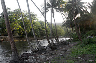
The Rosalie River is a river in Dominica. It rises on the eastern slopes of Morne Trois Pitons, flowing east to reach the Atlantic Ocean on the country's eastern coast, close to the town of Rosalie.
Bataka is a small town in Dominica. It is located in the northeast of the island, between Pagua Bay and Salybia. It is in the "America/Dominica" timezone and has a UTC offset of -4 hours.
Pont Cassé is situated in the Saint Paul Parish in Dominica. It is located almost in the middle of Dominica, close to Belles Village northeast of the national capital, Roseau, and close to Morne Trois Pitons, the mountain which dominates the southern center of the country. As of 2006 it has a population of 100.
The Belfast River is a river on the Caribbean island of Dominica. Due to geothermal activity near the river's midpoint, parts of the river flow at near-boiling temperatures.
The Belle Fille River is a river on the Caribbean island of Dominica.
The River Bway is a river on the Caribbean island of Dominica.
The River Claire is a river on the Caribbean island of Dominica.
Clarke's River is a river on the Caribbean island of Dominica.
The Hampstead River is a river on the Caribbean island of Dominica.

The Pagua River is one of the longest rivers on the Caribbean island of Dominica. It originates in the D'Leau Gommier area of the Central Forest Reserve, where it shares the same watershed as the Layou River. It flows northeastward, forming the western boundary of the Carib Territory. It empties into the Atlantic Ocean in Pagua Bay, on Dominica's east coast.
The Penton River is a river on the Caribbean island of Dominica.
The Savane River is a river on the Caribbean island of Dominica.
The Taberi River is a river on the Caribbean island of Dominica.
The River Subaya is a river on the Caribbean island of Dominica.
Petit Soufrière is a small village on the east coast of Dominica, upland from Petite Soufrière Bay in Saint David Parish. Located on the steep, rugged slopes of Morne Aux Delices at the end of the main road south from Castle Bruce, it is one of the most isolated villages in Dominica. The village immediately to its north is Saint Sauveur; to its south, though connected only by a hiking trail, is Rosalie.
For the definition of town, village, etc see Settlements in Dominica. | |
| Towns |
|
| Villages |
|
| General | |
|---|---|
| National libraries | |
Coordinates: 15°22′N61°16′W / 15.367°N 61.267°W
| | This Dominica location article is a stub. You can help Wikipedia by expanding it. |