
Dominica is an island in the Caribbean Sea, located about halfway between the French islands of Guadeloupe and Martinique. Its coordinates are 15 25 N, 61 20 W. It is known as "The Nature Island of the Caribbean" due to its spectacular, lush, and varied flora and fauna, which is protected by an extensive natural park system. It is the fourth largest island in the Eastern Caribbean with a population of people mainly of African descent.

The geography of Switzerland encompasses the geographical features of Switzerland, a mountainous and landlocked country located in Western and Central Europe. Switzerland's natural landscape is marked by its numerous lakes and mountains. It is surrounded by 5 countries: Austria and Liechtenstein to the east, France to the west, Italy to the south and Germany to the north. Switzerland has a maximum north–south length of 220 kilometres (140 mi) and an east–west length of about 350 kilometres (220 mi).

The Americas, which are also collectively called America, are a landmass comprising the totality of North and South America. The Americas make up most of the land in Earth's Western Hemisphere and comprise the New World.

A village is a clustered human settlement or community, larger than a hamlet but smaller than a town, with a population typically ranging from a few hundred to a few thousand. Though villages are often located in rural areas, the term urban village is also applied to certain urban neighborhoods. Villages are normally permanent, with fixed dwellings; however, transient villages can occur. Further, the dwellings of a village are fairly close to one another, not scattered broadly over the landscape, as a dispersed settlement.

Roseau is the capital and largest city of Dominica, with a population of 14,725 as of 2011. It is a small and compact urban settlement, in the Saint George parish and surrounded by the Caribbean Sea, the Roseau River and Morne Bruce. Built on the site of the ancient Island Carib village of Sairi, it is the oldest and most important urban settlement on the island of Dominica.

The City of Longmont is a home rule municipality located in Boulder and Weld counties, Colorado, United States. Longmont is located northeast of the county seat of Boulder and 33 miles (53 km) north-northwest of the Colorado State Capitol in Denver.
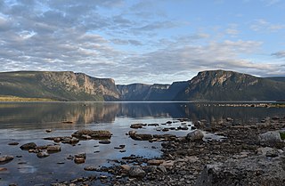
Gros Morne National Park is a Canadian national park and World Heritage Site located on the west coast of Newfoundland. At 1,805 km2 (697 sq mi), it is the second largest national park in Atlantic Canada after Torngat Mountains National Park, which has an area of 9,700 km2 (3,700 sq mi).

Brisbane, sited on the Meanjin land of the Turrbal Country, is the capital and most populous city of the Australian state of Queensland, and the third-most populous city in Australia. Brisbane's metropolitan area has a population of around 2.6 million, and it lies at the centre of the South East Queensland metropolitan region, which encompasses a population of around 3.8 million. The Brisbane central business district is situated within a peninsula of the Brisbane River about 15 km (9 mi) from its mouth at Moreton Bay, a bay of the Coral Sea. The metropolitan area extends in all directions along the hilly floodplain of the Brisbane River Valley between Moreton Bay and the Taylor and D'Aguilar mountain ranges. It sprawls across several of Australia's most populous local government areas (LGAs) — most centrally the City of Brisbane, the most populous LGA in the nation.

The Central Coast is a peri-urban region in the Australian state of New South Wales (NSW), lying on the Tasman Sea coast to the north of Sydney and south of Newcastle.

Corner Brook is a city located on the west coast of the island of Newfoundland in the province of Newfoundland and Labrador, Canada.

North Wales, also known as the North of Wales, is a geographic region of Wales, encompassing its northernmost areas. It borders Mid Wales to the south, England to the east, and the Irish Sea to the north and west. The area is highly mountainous and rural, with Snowdonia National Park and the Clwydian Range, known for its mountains, waterfalls and trails, located wholly within the region. Its population is more concentrated in the north-east, and northern coastal areas of the region, whilst significant Welsh-speaking populations are situated in its western and rural areas. North Wales is imprecisely defined, lacking any exact definition or administrative structure. For the public purposes of health, policing and emergency services, and for statistical, economic and cultural purposes, North Wales is commonly defined administratively as its six most northern principal areas, but other definitions of the geographic region exist, with Montgomeryshire historically considered to be part of the region.
Saint David is one of Dominica's ten administrative parishes, located on the eastern side of the island. It is bordered by St. Andrew to the north; St. Joseph, St. Paul and St. George to the west; and St. Patrick to the south. It has an area of 131.6 km² (50.8 mi²), and has a population of 6,789.

Saint John is one of Dominica's 10 administrative parishes. It is bordered by St. Andrew to the east, and St. Peter and the Espagnole River to the south. It has an area of 59 km² (22.78 mi²).

Saint Joseph is one of Dominica's 10 administrative parishes. It is bordered by St. Peter to the north, St. Andrew to the northeast, St. David to the east, and St. Paul to the south. It has an area of 120.1 km² (46.37 mi²), and a population of 5,765.

Saint Patrick is one of Dominica's 10 administrative parishes. It is bordered by St. George, St. Luke and St. Mark to the west, and St. David to the north. It has an area of 84.4 km² (32.59 mi²), and has a population of 8,383.

Grand Bay-Westfield is an incorporated town in the western part of Kings County, New Brunswick, Canada. The town borders Saint John on its northwestern boundary.
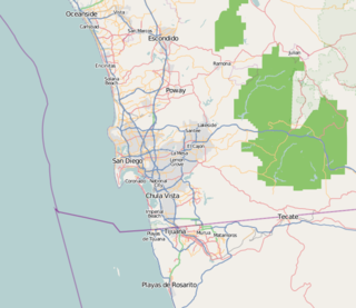
San Diego–Tijuana is an international transborder agglomeration, straddling the border of the adjacent North American coastal cities of San Diego, California, United States and Tijuana, Baja California, Mexico. The 2012 population of the region was 4,922,723, making it the largest bi-national conurbation shared between the United States and Mexico, the second-largest shared between the US and another country. In its entirety, the region consists of San Diego County in the United States and the municipalities of Tijuana, Rosarito Beach, and Tecate in Mexico. It is the third most populous region in the California–Baja California region, smaller only than the metropolitan areas of Greater Los Angeles and the San Francisco Bay Area.

Dominica, officially the Commonwealth of Dominica, is an island country in the Caribbean. The capital, Roseau, is located on the western side of the island. It is geographically situated as part of the Windward Islands chain in the Lesser Antilles archipelago in the Caribbean Sea. The island is surrounded by the French Republic with Guadeloupe to the northwest and Martinique to the south-southeast. Its area is 750 km2 (290 sq mi), and the highest point is Morne Diablotins, at 1,447 m (4,747 ft) in elevation. The population was 71,293 at the 2011 census.
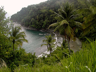
Petit Soufrière is a small village on the east coast of Dominica, upland from Petite Soufrière Bay in Saint David Parish. Located on the steep, rugged slopes of Morne Aux Delices at the end of the main road south from Castle Bruce, it is one of the most isolated villages in Dominica. The village immediately to its north is Saint Sauveur; to its south, though connected only by a hiking trail, is Rosalie.
