Carrollton, Missouri

Last updated

Carrollton, Missouri
Aerial view of Carrollton, Missouri - 9-2-2013.JPG
Aerial view of Carrollton, Missouri
Carroll County Missouri Incorporated and Unincorporated areas Carrollton Highlighted.svg
Location of Carrollton, Missouri
Coordinates: 39°21′49″N93°29′44″W / 39.36361°N 93.49556°W / 39.36361; -93.49556
Country United States
State Missouri
County Carroll
Government
  Type Mayor-council
   Mayor Frank Olvera
Area
[1]
  Total4.18 sq mi (10.84 km2)
  Land4.17 sq mi (10.80 km2)
  Water0.02 sq mi (0.04 km2)
Elevation
[2]
748 ft (228 m)
Population
 (2020)
  Total3,514
  Density843.09/sq mi (325.49/km2)
Time zone UTC-6 (Central (CST))
  Summer (DST) UTC-5 (CDT)
ZIP code
64633
Area code 660
FIPS code 29-11566 [3]
GNIS feature ID2393754 [2]
Website www.carrolltonmo.org

Carrollton is a city in Carroll County, Missouri, United States. Carrollton won the 2005 All-America City Award, given out annually by the National Civic League. The population was 3,514 at the 2020 census. [4] Carrollton is the county seat of Carroll County. [5]

Contents

History

Carroll County Courthouse Carroll-ch.jpg
Carroll County Courthouse

Carrollton was established in 1833. [6] It obtained its post office in 1834. [7] Carrollton's growth can be documented through Sanborn maps, several of which are available online. [8]

The Carroll County Court House, Carroll County Sheriff's Quarters and Jail, United States Post Office, and Wilcoxson and Company Bank are listed on the National Register of Historic Places. [9]

Geography

Carrollton is located in south central Carroll County at the intersection of US routes 24 and US Route 65. The Missouri River is five miles south of the city. [10]

According to the United States Census Bureau, the city has a total area of 4.19 square miles (10.85 km2), of which 4.17 square miles (10.80 km2) is land and 0.02 square miles (0.05 km2) is water. [11]

Climate

Climate data for Carrollton, Missouri (1991–2020 normals, extremes 1893–present)
MonthJanFebMarAprMayJunJulAugSepOctNovDecYear
Record high °F (°C)74
(23)
80
(27)
87
(31)
93
(34)
98
(37)
105
(41)
114
(46)
108
(42)
105
(41)
94
(34)
81
(27)
73
(23)
114
(46)
Mean daily maximum °F (°C)37.2
(2.9)
42.6
(5.9)
54.5
(12.5)
65.7
(18.7)
75.3
(24.1)
84.3
(29.1)
88.0
(31.1)
86.7
(30.4)
79.8
(26.6)
67.8
(19.9)
53.6
(12.0)
41.8
(5.4)
64.8
(18.2)
Daily mean °F (°C)27.3
(−2.6)
31.9
(−0.1)
42.7
(5.9)
53.5
(11.9)
64.1
(17.8)
73.6
(23.1)
77.5
(25.3)
75.7
(24.3)
67.7
(19.8)
55.6
(13.1)
42.7
(5.9)
32.1
(0.1)
53.7
(12.1)
Mean daily minimum °F (°C)17.4
(−8.1)
21.1
(−6.1)
31.0
(−0.6)
41.3
(5.2)
52.9
(11.6)
62.9
(17.2)
67.0
(19.4)
64.7
(18.2)
55.5
(13.1)
43.4
(6.3)
31.8
(−0.1)
22.5
(−5.3)
42.6
(5.9)
Record low °F (°C)−23
(−31)
−34
(−37)
−16
(−27)
14
(−10)
28
(−2)
41
(5)
47
(8)
42
(6)
28
(−2)
17
(−8)
−5
(−21)
−24
(−31)
−34
(−37)
Average precipitation inches (mm)1.41
(36)
1.85
(47)
2.51
(64)
3.92
(100)
5.13
(130)
5.37
(136)
4.27
(108)
4.39
(112)
4.28
(109)
3.16
(80)
2.21
(56)
1.58
(40)
40.08
(1,018)
Average snowfall inches (cm)4.8
(12)
3.3
(8.4)
1.1
(2.8)
0.2
(0.51)
0.0
(0.0)
0.0
(0.0)
0.0
(0.0)
0.0
(0.0)
0.0
(0.0)
0.3
(0.76)
0.9
(2.3)
2.1
(5.3)
12.7
(32)
Average precipitation days (≥ 0.01 in)5.65.58.610.512.110.18.48.37.58.66.55.697.3
Average snowy days (≥ 0.1 in)2.31.80.60.10.00.00.00.00.00.10.41.97.2
Source: NOAA [12] [13]

Demographics

Historical population
CensusPop.Note
1860 738
1870 1,832148.2%
1880 2,31326.3%
1890 3,87867.7%
1900 3,854−0.6%
1910 3,452−10.4%
1920 3,218−6.8%
1930 4,05826.1%
1940 4,0700.3%
1950 4,3807.6%
1960 4,5544.0%
1970 4,8476.4%
1980 4,700−3.0%
1990 4,406−6.3%
2000 4,122−6.4%
2010 3,784−8.2%
2020 3,514−7.1%
U.S. Decennial Census [14]

Education

Carrollton R-VII School District operates Carrollton Area Career Center, Carrollton High School; grades 9-12, Carrollton Junior High School; grades 7–8, and Carrollton Elementary School; grades Pre-1 and 2–6. [15]

The town has a lending library, the Carrollton Public Library. [16]

Notable people

Related Research Articles

<span class="mw-page-title-main">Carroll County, Missouri</span> County in Missouri, United States

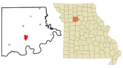
Carroll County is a county located in the U.S. state of Missouri. As of the 2020 census, the county had a population of 8,495. Its county seat is Carrollton. The county was organized on January 2, 1833, from part of Ray County and named for Charles Carroll of Carrollton, a signer of the Declaration of Independence.

<span class="mw-page-title-main">Carroll County, Arkansas</span> County in Arkansas, United States

Carroll County is a county located in the U.S. state of Arkansas. As of the 2020 census, the population was 28,260. The county has two county seats, Berryville and Eureka Springs. Carroll County is Arkansas's 26th county, formed on November 1, 1833, and named after Charles Carroll, the last surviving signer of the United States Declaration of Independence.

<span class="mw-page-title-main">Lamar, Missouri</span> City in Missouri, United States

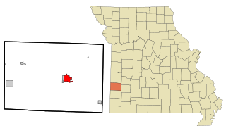
Lamar is a city in and the county seat of Barton County, Missouri, United States. As of the 2020 census, the city population was 4,266. It is known as the birthplace of Harry S. Truman, the 33rd president of the United States.

<span class="mw-page-title-main">Norborne, Missouri</span> City in Missouri, United States

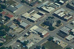
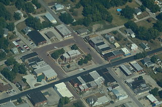
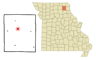
Norborne is a city in southwest Carroll County, Missouri, United States. The population was 634 at the 2020 census.

<span class="mw-page-title-main">Stockton, Missouri</span> City in Missouri, United States

Stockton is a city in Cedar County, Missouri, United States. The population was 1,683 at the 2020 census. It is the county seat of Cedar County.

<span class="mw-page-title-main">Maysville, Missouri</span> City in Missouri, United States

Maysville is a city in DeKalb County, Missouri, United States. The population was 1,095 at the 2020 census. Maysville is the county seat of DeKalb County.

<span class="mw-page-title-main">Albany, Missouri</span> City and County Seat in Missouri, United States

Albany is a city and county seat of Gentry County, Missouri, United States. With an annual growth rate of -0.30%. The population was 1,679 at the 2020 census.

<span class="mw-page-title-main">Edina, Missouri</span> City in Missouri, United States

Edina is a city in Knox County, Missouri, United States, between the North and South Forks of the South Fabius River. As of the 2020 census, its population was 1,012. It is the county seat of Knox County.

<span class="mw-page-title-main">Princeton, Missouri</span> City in Missouri, United States

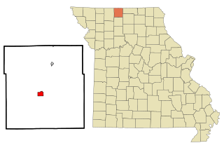
Princeton is the county seat and largest city of Mercer County, Missouri, United States. The population was 1,007 at the 2020 census, down from the 2010 census, which counted 1,166 people. Princeton, Missouri was also the birthplace of the famous frontierswoman Calamity Jane.

<span class="mw-page-title-main">Versailles, Missouri</span> City in Missouri, United States

Versailles is a city in Morgan County, Missouri, United States. The population was 2,482 at the 2010 census. It is the county seat of Morgan County. Locally, the town's name is pronounced “Ver-sails”, rather than “Ver-seye,” as in the French pronunciation of the royal palace for which the town is named.

<span class="mw-page-title-main">Alton, Missouri</span> City in Missouri, United States

Alton is a city and the county seat of Oregon County, Missouri, United States. The population was 707 at the 2020 census.

<span class="mw-page-title-main">Bowling Green, Missouri</span> City in Missouri, United States

Bowling Green is a city and the county seat of in Pike County, Missouri, United States. The population was 5,334 at the 2010 census.

<span class="mw-page-title-main">Clarksville, Missouri</span> City in Missouri, United States

Clarksville is a city in Calumet Township, Pike County, Missouri, United States. The population was 442 at the 2010 census.

<span class="mw-page-title-main">Sweet Springs, Missouri</span> City in Missouri, United States

Sweet Springs is a city in Saline County, Missouri, United States, along the Blackwater River. The population was 1,484 at the 2010 census.

<span class="mw-page-title-main">Shelbina, Missouri</span> City in Missouri, United States

Shelbina is a city in southern Shelby County, Missouri, United States. The population was 1,613 at the 2020 census.

<span class="mw-page-title-main">Appleton City, Missouri</span> City in Missouri, United States

Appleton City is a city in St. Clair County, Missouri, United States. The population was 1,032 as of the 2020 census. It is the largest city in St. Clair County.

<span class="mw-page-title-main">Houston, Missouri</span> City in Missouri, United States

Houston is a city in Texas County, Missouri, United States. The population was 2,079 at the 2020 census. It is the county seat of Texas County.

<span class="mw-page-title-main">Marshfield, Missouri</span> City in Missouri, United States

Marshfield is a city in Missouri and the county seat of Webster County, Missouri. As of the 2010 census, the city population was 6,633. As of the 2020 census, Marshfield had a population of 7,458. It is part of the Springfield, Missouri, metropolitan area.

<span class="mw-page-title-main">Vandalia, Missouri</span> City in Missouri, United States

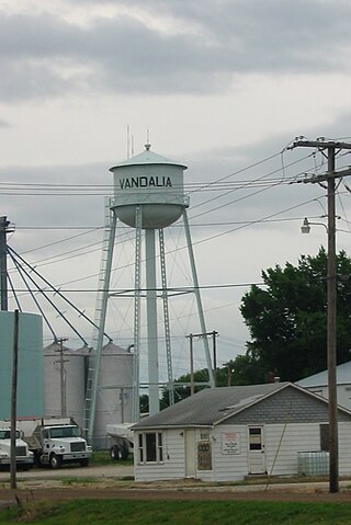
Vandalia is a city in northeastern Audrain and extending into southeastern Ralls Counties in the U.S. state of Missouri. The population was 3,553 at the 2020 census, which includes about 1,000 prisoners incarcerated at the prison located within the city limits.

<span class="mw-page-title-main">Mountain Grove, Missouri</span> City in Missouri, United States

Mountain Grove is a city in Wright County and Texas County in the U.S. state of Missouri. It lies within the Ozarks in the south-central part of the state. The population was 4,313 at the 2020 census.

References

  1. "ArcGIS REST Services Directory". United States Census Bureau. Retrieved August 28, 2022.
  2. 1 2 U.S. Geological Survey Geographic Names Information System: Carrollton, Missouri
  3. "U.S. Census website". United States Census Bureau . Retrieved January 31, 2008.
  4. "Explore Census Data". data.census.gov. Retrieved December 23, 2021.
  5. "Find a County". National Association of Counties. Archived from the original on May 31, 2011. Retrieved June 7, 2011.
  6. "Carroll County Place Names, 1928–1945 (archived)". The State Historical Society of Missouri. Archived from the original on June 24, 2016. Retrieved September 10, 2016.{{cite web}}: CS1 maint: bot: original URL status unknown (link)
  7. Earngey, Bill (1995). Missouri Roadsides: The Traveler's Companion. University of Missouri Press. p. 38. ISBN   9780826210210.
  8. Sanborn Maps for Missouri: Carrollton, University of Missouri Digital Library. Accessed 2011-03-14
  9. "National Register Information System". National Register of Historic Places . National Park Service. July 9, 2010.
  10. Missouri Atlas & Gazetteer, DeLorme, 1998, First edition, p. 28 ISBN   0-89933-224-2
  11. "US Gazetteer files 2010". United States Census Bureau. Archived from the original on July 2, 2012. Retrieved July 8, 2012.
  12. "NowData – NOAA Online Weather Data". National Oceanic and Atmospheric Administration. Retrieved August 2, 2021.
  13. "Station: Carrollton, MO". U.S. Climate Normals 2020: U.S. Monthly Climate Normals (1991-2020). National Oceanic and Atmospheric Administration. Retrieved August 2, 2021.
  14. "Census of Population and Housing". Census.gov. Retrieved June 4, 2015.
  15. "Schools". Carrollton R-VII School District. Retrieved March 23, 2018.
  16. "Missouri Public Libraries". PublicLibraries.com. Archived from the original on June 10, 2017. Retrieved March 23, 2018.