Savannah, Missouri

Last updated

Savannah, Missouri
Aerial view of Savannah, Missouri 9-2-2013.JPG
Aerial view of Savannah, Missouri
Andrew County Missouri Incorporated and Unincorporated areas Savannah Highlighted.svg
Location of Savannah, Missouri
Savannah-mo-map.gif
Coordinates: 39°56′21″N94°49′41″W / 39.93917°N 94.82806°W / 39.93917; -94.82806
Country United States
State Missouri
County Andrew
Area
[1]
  Total3.26 sq mi (8.45 km2)
  Land3.25 sq mi (8.42 km2)
  Water0.01 sq mi (0.04 km2)
Elevation
[2]
1,076 ft (328 m)
Population
 (2020)
  Total5,069
  Density1,559.69/sq mi (602.21/km2)
Time zone UTC-6 (Central (CST))
  Summer (DST) UTC-5 (CDT)
ZIP code
64485
Area code 816
FIPS code 29-66044 [3]
GNIS feature ID2396545 [2]
Website savannahmo.net

Savannah is a city and county seat of Andrew County, Missouri, United States. [4] The population was 5,069 at the 2020 census.

Contents

History

Savannah was founded in 1841. [5] The city was named after Savannah Woods, the child of a first settler. [6] A post office called Savannah has been in operation since 1841. [7]

The Andrew County Courthouse was listed on the National Register of Historic Places in 1980. [8]

Geography

Savannah is located on Business 71 ten miles north of St Joseph. The One Hundred and Two River flows past two miles east of the city and the Happy Hollar Lake Conservation Area is three miles to the northeast. [9]

According to the United States Census Bureau, the city has a total area of 3.15 square miles (8.16 km2), of which 3.14 square miles (8.13 km2) is land and 0.01 square miles (0.03 km2) is water. [10]

Demographics

Historical population
CensusPop.Note
1850 654
1860 82225.7%
1870 1,25752.9%
1880 1,206−4.1%
1890 1,2886.8%
1900 1,88646.4%
1910 1,583−16.1%
1920 1,83115.7%
1930 1,8883.1%
1940 2,10811.7%
1950 2,33210.6%
1960 2,4555.3%
1970 3,32435.4%
1980 4,18425.9%
1990 4,3524.0%
2000 4,7629.4%
2010 5,0576.2%
2020 5,0690.2%
U.S. Decennial Census [11]

Savannah is part of the St. Joseph, MO KS Metropolitan Statistical Area.

2010 census

As of the census [12] of 2010, there were 5,057 people, 2,043 households, and 1,327 families living in the city. The population density was 1,610.5 inhabitants per square mile (621.8/km2). There were 2,187 housing units at an average density of 696.5 per square mile (268.9/km2). The racial makeup of the city was 97.7% White, 0.4% African American, 0.3% Native American, 0.5% Asian, 0.3% from other races, and 0.8% from two or more races. Hispanic or Latino of any race were 1.6% of the population.

There were 2,043 households, of which 34.2% had children under the age of 18 living with them, 47.3% were married couples living together, 12.5% had a female householder with no husband present, 5.1% had a male householder with no wife present, and 35.0% were non-families. 30.4% of all households were made up of individuals, and 17% had someone living alone who was 65 years of age or older. The average household size was 2.41 and the average family size was 2.99.

The median age in the city was 38 years. 25.7% of residents were under the age of 18; 8.5% were between the ages of 18 and 24; 23.8% were from 25 to 44; 22.8% were from 45 to 64; and 19.1% were 65 years of age or older. The gender makeup of the city was 45.4% male and 54.6% female.

2000 census

As of the census [3] of 2000, there were 4,763 people, 1,927 households, and 1,266 families living in the city. The population density was 1,523.2 inhabitants per square mile (588.1/km2). There were 2,038 housing units at an average density of 651.9 per square mile (251.7/km2). The racial makeup of the city was 98.38% White, 0.29% African American, 0.38% Native American, 0.21% Asian, 0.25% from other races, and 0.48% from two or more races. Hispanic or Latino of any race were 0.59% of the population.

There were 1,927 households, out of which 32.1% had children under the age of 18 living with them, 51.8% were married couples living together, 10.9% had a female householder with no husband present, and 34.3% were non-families. 30.9% of all households were made up of individuals, and 17.5% had someone living alone who was 65 years of age or older. The average household size was 2.38 and the average family size was 2.99.

In the city, the population was spread out, with 25.5% under the age of 18, 8.6% from 18 to 24, 26.0% from 25 to 44, 19.4% from 45 to 64, and 20.6% who were 65 years of age or older. The median age was 38 years. For every 100 females, there were 81.7 males. For every 100 females age 18 and over, there were 77.2 males.

The median income for a household in the city was $32,996, and the median income for a family was $40,615. Males had a median income of $31,450 versus $20,851 for females. The per capita income for the city was $17,809. About 10.2% of families and 11.8% of the population were below the poverty line, including 17.6% of those under age 18 and 8.9% of those age 65 or over.

Education

Public education in Savannah is administered by Savannah R-III School District. [13]

Savannah has a public library, the Savannah Branch library. [14]

Notable people

Books

Books that have Savannah, Missouri as either a major or minor plot setting:

Has It Come to This? The Mysterious, Unsolved Murder of Frank Richardson (2022) by Kimberly Tilley (true crime/non-fiction/American history)

Related Research Articles

<span class="mw-page-title-main">Gilpin County, Colorado</span> County in Colorado, United States

Gilpin County is a county located in the U.S. state of Colorado, smallest in land area behind only the City and County of Broomfield. As of the 2020 census, the population was 5,808. The county seat is Central City. The county was formed in 1861, while Colorado was still a territory, and was named after Colonel William Gilpin, the first territorial governor.

<span class="mw-page-title-main">Waverly, Florida</span> Census-designated place in Florida, United States

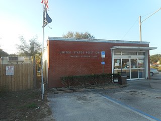
Waverly is a census-designated place (CDP) in east-central Polk County, Florida, United States. The population was 1,927 at the 2000 census. It is part of the Lakeland–Winter Haven Metropolitan Statistical Area.

<span class="mw-page-title-main">Star, Idaho</span> City in Idaho, United States

Star is a city in northwestern Ada County, Idaho, with parts stretching into neighboring Canyon County. The population was 11,117 at the 2020 census, up from 5,793 in 2010. It was named in the 19th century by travelers on their way to Middleton and Boise who used the star on the school house to find east and west. The name stuck and it became Star, Idaho. Today, it is a rapidly growing suburb of Boise and its schools are shared with Middleton School District and West Ada School District.

<span class="mw-page-title-main">Waukee, Iowa</span> City in Iowa, United States

Waukee is a city in Dallas County, Iowa, United States. The population was 23,940 at the time of the 2020 U.S. Census. It is part of the Des Moines – West Des Moines Metropolitan Statistical Area.

<span class="mw-page-title-main">Murray Hill, Kentucky</span> City in Kentucky, United States

Murray Hill is a home rule-class city in Jefferson County, Kentucky, United States, and a part of the Louisville Metro government. The population was 582 during the 2010 census.

<span class="mw-page-title-main">Wheaton, Missouri</span> City in Missouri, United States

Wheaton is a city in Wheaton Township, Barry County, Missouri, United States. The population was 696 at the 2010 census.

<span class="mw-page-title-main">Belton, Missouri</span> City in Missouri, United States

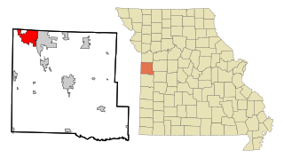
Belton is a city in northwestern Cass County, Missouri, United States. The population was 23,953 at the 2020 census.

<span class="mw-page-title-main">Harrisonville, Missouri</span> City in Missouri, United States

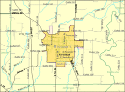
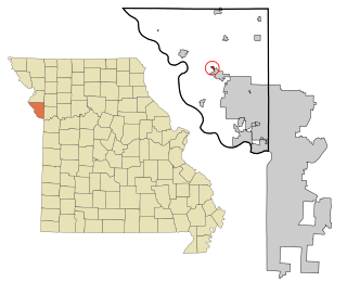
Harrisonville is a city in Cass County, Missouri, United States. The population was 10,121 at the 2020 census. It is the county seat of Cass County. It is part of the Kansas City metropolitan area.

<span class="mw-page-title-main">Lebanon, Missouri</span> City in Missouri, United States

Lebanon is a city in and the county seat of Laclede County in Missouri. The population was 14,474 at the time of the 2010 census. It is the county seat of Laclede County. The Lebanon Micropolitan Statistical Area consists of Laclede County.

<span class="mw-page-title-main">Linneus, Missouri</span> City in Missouri, United States

Linneus is a small city in Linn County, Missouri, United States. The population was 281 at the 2020 census. It is the county seat of Linn County.

<span class="mw-page-title-main">Tracy, Missouri</span> City in Missouri, United States

Tracy is a city in Platte County, Missouri within the United States, located along the Platte River. The population was 269 at the 2020 census. The city is part of the Kansas City metropolitan area.

<span class="mw-page-title-main">Nelson, Missouri</span> City in Missouri, United States

Nelson is a city in Saline County, Missouri, United States. The population was 152 at the 2020 census.

<span class="mw-page-title-main">Benton, Missouri</span> City in Missouri, United States

Benton is a city in Scott County, Missouri, United States. The population was 863 at the 2010 census. It is the county seat of Scott County.

<span class="mw-page-title-main">Shelbyville, Missouri</span> City in Missouri, United States

Shelbyville is a city in Shelby County, Missouri, United States. The population was 518 at the 2020 census. It is the county seat of Shelby County.

<span class="mw-page-title-main">Manchester, Missouri</span> City in Missouri, United States

Manchester is a city in St. Louis County, Missouri, United States. The population was 18,333 at the 2020 census.

<span class="mw-page-title-main">Velda City, Missouri</span> City in Missouri, United States

Velda City is a city in St. Louis County, Missouri, United States. The population was 1,420 at the 2010 census.

<span class="mw-page-title-main">Wildwood, Missouri</span> City in Missouri, United States

Wildwood is a city in St. Louis County, Missouri, United States. It is located in the far western portion of the county. As of the 2020 census, the population was 35,417. Wildwood is the home of the Al Foster Trail, and numerous other trails, parks, and reserves such as Rockwoods Reservation and Babler State Park.

<span class="mw-page-title-main">Schell City, Missouri</span> City in Missouri, United States

Schell City is a city in northeast Vernon County, Missouri, United States. The population was 249 at the 2010 census.

<span class="mw-page-title-main">Moline Acres, Missouri</span> City in Missouri, United States

Moline Acres is a city in St. Louis County, Missouri, United States. The population was 2,442 at the 2010 census.

<span class="mw-page-title-main">Stanfield, Oregon</span> City in Oregon, United States

Stanfield is a city in Umatilla County, Oregon, United States. The population was 2,043 at the 2010 census. It is part of the Pendleton–Hermiston Micropolitan Statistical Area.

References

  1. "ArcGIS REST Services Directory". United States Census Bureau. Retrieved August 28, 2022.
  2. 1 2 U.S. Geological Survey Geographic Names Information System: Savannah, Missouri
  3. 1 2 "U.S. Census website". United States Census Bureau . Retrieved January 31, 2008.
  4. "Find a County". National Association of Counties. Retrieved June 7, 2011.
  5. Eaton, David Wolfe (1916). How Missouri Counties, Towns and Streams Were Named. The State Historical Society of Missouri. pp.  202.
  6. "Andrew County Place Names, 1928-1945 (archived)". The State Historical Society of Missouri. Archived from the original on June 24, 2016. Retrieved August 30, 2016.{{cite web}}: CS1 maint: bot: original URL status unknown (link)
  7. "Post Offices". Jim Forte Postal History. Retrieved August 30, 2016.
  8. "National Register Information System". National Register of Historic Places . National Park Service. July 9, 2010.
  9. Missouri Atlas & Gazetteer, DeLorme, 1st ed, 1998, p. 19 ISBN   0-89933-224-2
  10. "US Gazetteer files 2010". United States Census Bureau. Archived from the original on January 25, 2012. Retrieved July 8, 2012.
  11. "Census of Population and Housing". Census.gov. Retrieved June 4, 2015.
  12. "U.S. Census website". United States Census Bureau . Retrieved July 8, 2012.
  13. "Homepage". Savannah R-III School District. Retrieved June 5, 2019.
  14. "Missouri Public Libraries". PublicLibraries.com. Archived from the original on June 10, 2017. Retrieved June 4, 2019.
  15. Eminem's mom gives her side of the story today.msnbc.com - November 6, 2008