Kingston, Missouri | |
---|---|
Coordinates: 39°38′33″N94°02′18″W / 39.64250°N 94.03833°W | |
Country | United States |
State | Missouri |
County | Caldwell |
Area | |
• Total | 0.52 sq mi (1.35 km2) |
• Land | 0.52 sq mi (1.34 km2) |
• Water | 0.00 sq mi (0.01 km2) |
Elevation | 909 ft (277 m) |
Population (2020) | |
• Total | 290 |
• Density | 558.77/sq mi (215.73/km2) |
Time zone | UTC-6 (Central (CST)) |
• Summer (DST) | UTC-5 (CDT) |
ZIP code | 64650 |
Area code | 816 |
FIPS code | 29-38846 [3] |
GNIS feature ID | 2395539 [2] |
Kingston is a city in Caldwell County, Missouri, and is part of the Kansas City metropolitan area with the United States. The population was 290 at the 2020 census. [4] It is the county seat of Caldwell County. [5]
Kingston was laid out in 1843, and named for Austin Augustus King, at the time judge, and afterward 10th Governor of Missouri. [6] [7] A post office has been in operation at Kingston since 1843. [8]
The Caldwell County Courthouse and Far West are listed on the National Register of Historic Places. [9]
According to the United States Census Bureau, the city has a total area of 0.52 square miles (1.35 km2), all land. [10]
Census | Pop. | Note | %± |
---|---|---|---|
1870 | 414 | — | |
1880 | 470 | 13.5% | |
1890 | 465 | −1.1% | |
1900 | 655 | 40.9% | |
1910 | 535 | −18.3% | |
1920 | 371 | −30.7% | |
1930 | 395 | 6.5% | |
1940 | 394 | −0.3% | |
1950 | 338 | −14.2% | |
1960 | 311 | −8.0% | |
1970 | 291 | −6.4% | |
1980 | 280 | −3.8% | |
1990 | 279 | −0.4% | |
2000 | 287 | 2.9% | |
2010 | 348 | 21.3% | |
2020 | 290 | −16.7% | |
U.S. Decennial Census [11] |
As of the census [12] of 2010, there were 348 people, 107 households, and 62 families living in the city. The population density was 669.2 inhabitants per square mile (258.4/km2). There were 133 housing units at an average density of 255.8 per square mile (98.8/km2). The racial makeup of the city was 76.4% White, 5.7% African American, 0.9% Asian, 16.1% from other races, and 0.9% from two or more races. Hispanic or Latino of any race were 17.5% of the population.
There were 107 households, of which 24.3% had children under the age of 18 living with them, 48.6% were married couples living together, 6.5% had a female householder with no husband present, 2.8% had a male householder with no wife present, and 42.1% were non-families. 38.3% of all households were made up of individuals, and 16.8% had someone living alone who was 65 years of age or older. The average household size was 2.15 and the average family size was 2.87.
The median age in the city was 37.7 years. 12.6% of residents were under the age of 18; 13.2% were between the ages of 18 and 24; 37% were from 25 to 44; 23.8% were from 45 to 64; and 13.2% were 65 years of age or older. The gender makeup of the city was 63.5% male and 36.5% female.
As of the census [3] of 2000, there were 287 people, 123 households, and 76 families living in the city. The population density was 493.9 inhabitants per square mile (190.7/km2). There were 137 housing units at an average density of 235.7 per square mile (91.0/km2). The racial makeup of the city was 98.95% White, 0.35% African American, and 0.70% from two or more races. Hispanic or Latino of any race were 0.35% of the population.
There were 123 households, out of which 30.1% had children under the age of 18 living with them, 54.5% were married couples living together, 6.5% had a female householder with no husband present, and 38.2% were non-families. 35.0% of all households were made up of individuals, and 21.1% had someone living alone who was 65 years of age or older. The average household size was 2.33 and the average family size was 3.09.
In the city, the population was spread out, with 25.8% under the age of 18, 10.8% from 18 to 24, 25.4% from 25 to 44, 21.3% from 45 to 64, and 16.7% who were 65 years of age or older. The median age was 37 years. For every 100 females, there were 88.8 males. For every 100 females age 18 and over, there were 85.2 males.
The median income for a household in the city was $23,889, and the median income for a family was $27,500. Males had a median income of $25,417 versus $18,125 for females. The per capita income for the city was $11,867. About 15.4% of families and 17.2% of the population were below the poverty line, including 30.9% of those under the age of eighteen and 10.0% of those 65 or over.
Kingston 42 School District operates the Kingston Elementary School in the city. [13]
The city has a public library, the Caldwell County Library. [14]
Caldwell is a city in Sumner County, Kansas, United States. As of the 2020 census, the population of the city was 1,025.
Wheaton is a city in Wheaton Township, Barry County, Missouri, United States. The population was 696 at the 2010 census.
Breckenridge is a city in northeast Caldwell County, Missouri, and is part of the Kansas City metropolitan area with the United States. The population was 258 at the 2020 census.
Kidder is a city in northwest Caldwell County, Missouri, The population was 267 at the 2020 census.
Polo is a city in southwest Caldwell County, Missouri, and is part of the Kansas City metropolitan area with the United States. The population was 509 at the 2020 census.
Belton is a city in northwestern Cass County, Missouri, United States. The population was 23,953 at the 2020 census.
Liberty is a city in and the county seat of Clay County, Missouri, United States and is a suburb of Kansas City, located in the Kansas City Metropolitan Area. As of the 2020 United States Census the population was 30,167. Liberty is home to William Jewell College.
Smithville is a city in Clay and Platte counties in the U.S. state of Missouri and is part of the Kansas City metropolitan area, along the Little Platte River. The population was 10,406 at the 2020 United States Census.
Linneus is a small city in Linn County, Missouri, United States. The population was 281 at the 2020 census. It is the county seat of Linn County.
Green Park is a city in St. Louis County, Missouri, United States. The population was 2,622 at the 2010 census.
Greendale is a city in St. Louis County, Missouri, United States. The population was 651 at the 2010 census.
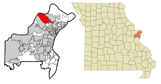
Hazelwood is a city in St. Louis County, Missouri, within Greater St. Louis. It is a second-ring northern suburb of St. Louis. Based on the 2020 United States census, the city had a total population of 25,485. It is located north of St. Louis-Lambert International Airport and is situated on Interstates 270 and 170, as well as the much-traveled Lindbergh Boulevard and Highway 370.
Manchester is a city in St. Louis County, Missouri, United States. The population was 18,333 at the 2020 census.
Pine Lawn is a city in St. Louis County, Missouri, United States. The population was 3,275 at the 2010 census.
Velda City is a city in St. Louis County, Missouri, United States. The population was 1,420 at the 2010 census.
Wildwood is a city in St. Louis County, Missouri, United States. It is located in the far western portion of the county. As of the 2020 census, the population was 35,417. Wildwood is the home of the Al Foster Trail, and numerous other trails, parks, and reserves such as Rockwoods Reservation and Babler State Park.
Cowgill is a city in southern Caldwell County, Missouri, and is part of the Kansas City metropolitan area with the United States. The population was 168 at the 2020 census.
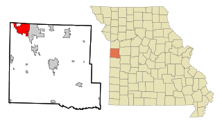
Cameron is a city in Clinton, DeKalb and Caldwell counties in the U.S. state of Missouri. The population was 8,513 at the 2020 census.
Blackburn is a city in Lafayette and Saline counties in the U.S. state of Missouri and is part of the Kansas City metropolitan area. The population was 224 at the 2020 census.
Miner is a city in Mississippi and Scott counties in the U.S. state of Missouri. It is bordered to the west by the city of Sikeston. The population was 916 at the 2020 census.