Catalina Highway

Last updated

National Forest Scenic Byway.svg

Catalina Highway

General Hitchcock Highway, Sky Island Scenic Byway, Mt Lemmon Highway
Catalina Highway
Catalina Highway highlighted in red
Route information
Maintained by US Forest Service
Length27 mi (43 km)
Existed1933–present
Tourist
routes
Arizona Scenic Road Marker.svg Sky Island Parkway [1]
Major junctions
South endTanque Verde Road in Tucson
North endNear the summit of Mount Lemmon
Location
Country United States
State Arizona
Counties Pima, Arizona
Highway system
  • Arizona State Highway System
Forest Highways

The Catalina Highway, officially the General Hitchcock Highway, is the popular name for a Forest Highway and scenic route located in Pima County in southern Arizona. Also known as the Sky Island Scenic Byway, the Mount Lemmon Highway and Arizona Forest Highway 39, the Catalina Highway is the only paved roadway providing access to the resort village of Summerhaven as well as various recreational and scientific facilities located near the summit of Mount Lemmon. Ascending from the desert floor in Tucson to near the summit of Mount Lemmon, the short highway gains over 6,000 ft (1,800 m), showcasing a variety of climates ranging from lowland desert to alpine forests. [2] The name sky island comes from the analogy of these mountains being like islands of forest in a sea of desert. It is designated as a scenic byway by the National Scenic Byways Program. [3] and an Arizona Scenic Road by the Federal Highway Administration. [4]

Contents

Route description

The Catalina Highway traverses the rugged terrain of the Santa Catalina Mountains. SkyIslandPkwy.JPG
The Catalina Highway traverses the rugged terrain of the Santa Catalina Mountains.

The Catalina Highway begins at its intersection with Tanque Verde Road in northeast Tucson, traversing the unincorporated community of Tanque Verde before crossing into the Coronado National Forest. At this point, the roadway officially becomes the General Hitchcock Highway (Arizona Forest Highway 39), although many maps reflect the common usage of "Catalina Highway" to refer to the entire roadway.

From the boundary with the National Forest, the highway takes a winding route through the Santa Catalina Mountains by way of Molino Canyon. Due to the rapid gain in elevation there are numerous switchbacks, but the road follows a generally northward direction, passing Willow Canyon, until reaching Forest Road 9 and Rose Canyon Lake, after which it begins traveling in a generally northwestern direction, passing Whitetail and Soldier Camp, to the village of Summerhaven.

The final segment of the road, sometimes signed as Ski Run Road, heads east to the Mount Lemmon Ski Valley and ultimately approaches its final terminus near the summit of Mount Lemmon. [2]

History

Gordon Hirabayashi, seen here in 1986, was one of many Japanese-Americans forced to work on the highway's construction. Gordon Hirabayashi NPS.jpg
Gordon Hirabayashi, seen here in 1986, was one of many Japanese-Americans forced to work on the highway's construction.

Construction on the Catalina Highway began in 1933, owing in large part to the efforts of Frank Harris Hitchcock, publisher of the Tucson Citizen and former Postmaster General of the United States. In order to create a route to the popular destinations at the summit of Mount Lemmon, Hitchcock spearheaded the effort to bring together the funds and resources to construct an improved road to Summerhaven and nearby facilities. As a part of the effort, a federal prison camp was established at the foot of the mountains specifically to supply labor for the construction of the highway. [2] During World War II, the camp was converted into an internment camp named the Catalina Honor Camp, and the internees were forced to work on construction of the roadway. One of the Japanese American prisoners at the camp, Gordon Hirabayashi, was later honored in 1999 when the site of the Honor Camp was converted into the Gordon Hirabayashi Recreation Area. [4]

The highway would not be completed until 1950, 17 years after it began. Upon its completion, the highway was named after Hitchcock, who had died in 1935.

The original paved road was narrow, in places had little or no shoulder, featured vertical drop-offs near the road, and was bumpy along most of its length due to years of patchwork repairs. It was long regarded as "one of the most dangerous roads in Pima County."[ citation needed ] In 1988, the Federal Lands Highway program began a series of seven projects aimed at significantly improving the roadway, with the assistance of the US Forest Service and Pima County. The projects were aimed at improving the quality of the roadway and increasing safety for travelers, while minimizing the impact on the visual aspects and natural beauty of the surrounding mountains. The final project was completed in 2007, at a cost of $15 million, and the road is now much wider and features adequate shoulders, passing areas, and extensive guard rails. [5]

The roadway was awarded with the Arizona Engineering Excellence Grand Award for Context Sensitive Design in 2005 for minimizing damage to existing terrain and pinnacles and careful preservation of the delicate environment.

Tourism

The Catalina Highway is a common destination for motorcyclists. Mtlemmon600.jpg
The Catalina Highway is a common destination for motorcyclists.

The Catalina Highway provides the only paved access to attractions on Mount Lemmon and the Santa Catalina Mountains, and has become a popular destination for tourism in the region. According to the Federal Highway Administration, the Catalina Highway is traveled over by more than one million visitors every year. [5] Among the many recreational opportunities in the Coronado National Forest, through which the highway travels, are numerous campgrounds and picnic sites, multi-use trails, and scenic views. The Mount Lemmon Ski Valley, located at the summit of the highway, operates a ski slope during the winter months and remains open during the summer, offering summer "sky rides" on the ski lift. It is billed as the southernmost ski resort in the continental United States. [6]

In addition to the numerous recreational activities the highway offers access to, the highway's status as a Scenic Drive is a draw in and of itself. The Forest Service describes the drive as a biological and ecological tour from Mexico to Canada in only 27 miles. [2] Over the length of the drive, visitors will encounter saguaro cacti, mesquite trees, and cholla plants of the Sonoran Desert, pass through stands of oak, juniper, and pinyon pine, enter pine forests and then finally stands of fir and aspen on the cooler, north-facing slopes at the end of the highway.

The scenic vistas afforded along the highway, along with the terrain, make it a common destination for leisure travel and motorcycling. [7] The route is also popular with bicycling enthusiasts, providing a significant challenge of skill. Local cycling organizations regularly organize rides consisting of 200 or more riders along the highway to the summit of the mountain. [8]

October 2010 saw the inaugural running of the Mount Lemmon Marathon which saw nearly 800 participants finish the race from near the start of the highway up to Summerhaven. [9]

Major intersections

The entire route is in Pima County.

LocationmikmDestinationsNotes
Tucson 0.00.0Tanque Verde RoadSouthern terminus
Harrison Road
Prince Road
Houghton Road
Snyder Road
27.043.5Dead end near Mt. Lemmon Northern terminus
1.000 mi = 1.609 km; 1.000 km = 0.621 mi

Related Research Articles

<span class="mw-page-title-main">U.S. Route 89</span> Highway in the United States

U.S. Route 89 is a north–south United States Numbered Highway with two sections, and one former section. The southern section runs for 848 miles (1,365 km) from Flagstaff, Arizona, to the southern entrance of Yellowstone National Park. The northern section runs for 404 miles (650 km) from the northern entrance of Yellowstone National Park in Montana, ending at the Canadian border. Unnumbered roads through Yellowstone connect the two sections. Before 1992, US 89 was a Canada–Mexico, border-to-border highway that ended at Nogales, Arizona, on its southern end.

<span class="mw-page-title-main">Santa Catalina Mountains</span> Mountain range in Pima and Pinal counties, Arizona, United States

The Santa Catalina Mountains, commonly referred to as the Catalina Mountains or the Catalinas, are north and northeast of Tucson in Arizona, United States, on Tucson's north perimeter. The mountain range is the most prominent in the Tucson area, with the highest average elevation. The highest point in the Catalinas is Mount Lemmon at an elevation of 9,157 feet (2,791 m) above sea level and receives 18 inches (46 cm) of precipitation annually.

<span class="mw-page-title-main">Angeles Crest Highway</span> Highway in California

The Angeles Crest Highway is a two-lane highway over the San Gabriel Mountains, in Los Angeles County, California. Its route is to/through the San Gabriel Mountains National Monument and the Angeles National Forest. With the exception of a 1,000 feet (300 m)-long section in La Cañada Flintridge, the entire route is part of California State Route 2.

<span class="mw-page-title-main">Sabino Canyon</span> Landform in Pima County, Arizona

Sabino Canyon is a significant canyon located in the Santa Catalina Mountains and the Coronado National Forest north of Tucson, Arizona, United States. Sabino Canyon is a popular recreation area for residents and visitors of Southern Arizona, providing a place to walk, hike or ride. Minutes away from the desert are large waterfalls along Sabino Creek with minor bridges constructed over them. Wildlife in the canyon includes a range of animals. Some of which are deer, javelina, skunks, tortoises, rattlesnakes and mountain lions. Like most places in Arizona, there are also owls, and scorpion which are very common in Tucson hiking trails.

<span class="mw-page-title-main">Mount Lemmon</span> Mountain in Arizona, United States

Mount Lemmon, with a summit elevation of 9,159 feet (2,792 m), is the highest point in the Santa Catalina Mountains. It is located in the Coronado National Forest north of Tucson, Arizona, United States. Mount Lemmon was named for botanist Sara Plummer Lemmon, who trekked to the top of the mountain with her husband and E. O. Stratton, a local rancher, by horse and foot in 1881. Mount Lemmon is also known as Babad Do'ag, or Frog Mountain to the Tohono O'odham.

<span class="mw-page-title-main">Aspen Fire</span> 2003 Wildfire in Pima County, Arizona

The Aspen Fire burned from June 17, 2003, for about a month on Mount Lemmon, part of the Santa Catalina Mountains located in the Coronado National Forest north of Tucson, Arizona, and in the surrounding area. It burned 84,750 acres (343.0 km2) of land, and destroyed 340 homes and businesses of the town of Summerhaven.

<span class="mw-page-title-main">Tucson Mountains</span> Landform in Pima County, Arizona

The Tucson Mountains are a minor mountain range west of Tucson, Arizona, United States. The Tucson Mountains, including Wasson Peak, are one of four notable mountain ranges surrounding the Tucson Basin. The Santa Catalina Mountains lie to the northeast, the Rincon Mountains are to the east of Tucson, and the Santa Rita Mountains lie to the south. Additionally, the Sierrita Mountains lie due south, the Roskruge Mountains lie to the west across Avra Valley, the Silver Bell Mountains lie to the northwest, and the Tortolita Mountains lie to the north across the Santa Cruz Valley.

<span class="mw-page-title-main">Summerhaven, Arizona</span> CDP in Pima County, Arizona

Summerhaven is a small unincorporated community and census-designated place (CDP) on Mount Lemmon in the Santa Catalina Mountains north of Tucson in Pima County, Arizona, United States. As of the 2010 census it had a permanent population of 40. Summerhaven sits at an elevation of approximately 7,600 to 8,200 feet above sea level. Summerhaven is accessed via the Catalina Highway from suburban northeast Tucson, and it is about 24.5 miles (39.4 km) from the base of the mountains to Summerhaven.

<span class="mw-page-title-main">U.S. Route 16A</span>

U.S. Highway 16A (US 16A) is a 36.971-mile-long (59.499 km) scenic United States Numbered Highway. It is an alternate route for US 16. It splits from US 16 in the Black Hills of the southwestern part of the U.S. state of South Dakota. The highway's western terminus is an intersection with US 16, US 385, and South Dakota Highway 89 (SD 89) in Custer. The eastern terminus is at an interchange with US 16 called Keystone Wye south of Rapid City. Portions of US 16A are known as the Iron Mountain Road, named after the peak it summits.

<span class="mw-page-title-main">Mount Lemmon Observatory</span> Astronomical observatory in Arizona, United States

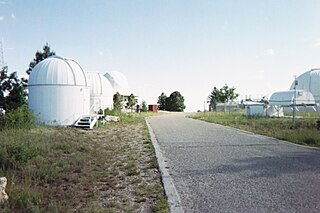
Mount Lemmon Observatory (MLO), also known as the Mount Lemmon Infrared Observatory, is an astronomical observatory located on Mount Lemmon in the Santa Catalina Mountains approximately 28 kilometers (17 mi) northeast of Tucson, Arizona (US). The site in the Coronado National Forest is used with special permission from the U.S. Forest Service by the University of Arizona's Steward Observatory, and contains a number of independently managed telescopes.

<span class="mw-page-title-main">Nevada State Route 431</span> Highway in Nevada

State Route 431, commonly known as the Mount Rose Highway, is a 24.413-mile-long (39.289 km) highway in Washoe County, Nevada, that connects Incline Village at Lake Tahoe with Reno. The highway, a Nevada Scenic Byway, takes its name from Mount Rose, which lies just off the highway. Prior to 1976, the highway existed as State Route 27.

<span class="mw-page-title-main">Mount Lemmon Ski Valley</span> Recreational ski area in Arizona, United States

Mount Lemmon Ski Valley is a recreational ski area in the U.S. state of Arizona, and the southernmost ski destination in the continental United States. Mount Lemmon Ski Valley is located on the slopes of Mount Lemmon in the Santa Catalina Mountains just north of Tucson, Arizona. It is part of the Coronado National Forest, located near the mountaintop village of Summerhaven. The summit is 9,157 feet (2,791 m) above sea level, and receives approximately 180 inches (4.6 m) of snow annually.

<span class="mw-page-title-main">Saguaro National Park</span> National park in Arizona, United States

Saguaro National Park is a United States national park in Pima County, southeastern Arizona. The 92,000-acre (37,000 ha) park consists of two separate areas—the Tucson Mountain District (TMD), about 10 miles (16 km) west of Tucson, and the Rincon Mountain District (RMD), about 10 miles (16 km) east of the city. Both districts preserve Sonoran Desert landscapes, fauna, and flora, including the giant saguaro cactus.

<span class="mw-page-title-main">Utah State Route 143</span> Highway in Utah

State Route 143 (SR-143) is a state highway in the U.S. state of Utah. The entire highway has been designated the Brian Head-Panguitch Lake Scenic Byway as part of the Utah Scenic Byways program. This road has also been designated as Utah's Patchwork Parkway as part of the National Forest Scenic Byway and National Scenic Byway programs.

<span class="mw-page-title-main">Mount Lemmon Marathon</span>

The Mount Lemmon Marathon were a pair of separate road race marathon events that took place in the Santa Catalina Mountains near the city of Tucson, Arizona, United States. The initial race, which was in the uphill direction, was held between 2010 and 2013. The uphill race started near the desert floor and ended at the village of Summerhaven near the top of Mount Lemmon.

<span class="mw-page-title-main">River Road National Scenic Byway</span> National Scenic Byway and National Forest Scenic Byway in Iosco County, Michigan, United States

The River Road National Scenic Byway is a National Scenic Byway and National Forest Scenic Byway in the US state of Michigan. This 23+12-mile-long (37.8 km) byway follows M-65 and River Road; it extends eastward into the Huron National Forest and ends in the historic community of Oscoda near Lake Huron. The road parallels the historic Au Sable River which has historically been a major transportation route for floating Michigan's giant white pine from the forest to the saw mill towns on Lake Huron. Along its course, the roadway offers access to several recreational areas as well as the local scenery. The section of the River Road that follows M-65 was added to the State Trunkline Highway System in the 1930s. The River Road was given National Forest Scenic Byway status in 1988, and National Scenic Byway status in 2005.

<span class="mw-page-title-main">Black River National Forest Scenic Byway</span> County road and National Forest Scenic Byway in Gogebic County, Michigan, United States

The Black River National Forest Scenic Byway is a National Forest Scenic Byway that runs along the Black River in the Ottawa National Forest in the U.S. state of Michigan. The byway follows County Road 513 (CR 513) through Gogebic County in the Upper Peninsula. As a county road, it is maintained jointly by the Gogebic County Road Commission (GCRC) with assistance from the U.S. Forest Service (USFS). The byway provides access to several waterfalls and other visitor attractions in the area. The route of the byway first existed as a wagon road in the 1840s and as a county road in the 1920s. The byway designation was instituted on June 20, 1992, and the byway was dedicated later that year.

<span class="mw-page-title-main">Sara Plummer Lemmon</span> American botanist

Sara Allen Plummer Lemmon, b. 1836, d. 1923 , was an American botanist. Mount Lemmon in Arizona is named for her, as she was the first white woman to ascend it. She was responsible for the designation of the golden poppy as the state flower of California, in 1903. A number of plants are also named in her honor, including the new genus Plummera, described by botanist Asa Gray in 1882.

References

  1. Arizona Department of Transportation (2014). "Arizona Parkways, Historic and Scenic Roads" (PDF). Phoenix: Arizona Department of Transportation. Archived from the original (PDF) on September 11, 2018. Retrieved September 11, 2018.
  2. 1 2 3 4 "Catalina Highway". USDA Forest Service. Retrieved 2009-06-12.
  3. "Sky Island Scenic Byway". National Scenic Byways Program. Archived from the original on 2009-02-07. Retrieved 2009-06-12.
  4. 1 2 Banks, Leo. "Sky Island Parkway (Catalina Highway)". Arizona Scenic Roads. Retrieved 2009-06-12.[ permanent dead link ]
  5. 1 2 "Forest Highways" (PDF). Federal Highway Administration. 2008-04-01. Retrieved 2009-06-12.
  6. "Mt. Lemmon Ski Valley". USDA Forest Service. Retrieved 2009-06-12.
  7. "Catalina Highway (Sky Island) – Arizona Motorcycle Roads and Rides". www.motorcycleroads.com. Retrieved 25 June 2017.
  8. Presnell, Kelly (2009-05-14). "A long ride up Mt. Lemmon". Arizona Daily Star . Retrieved 2009-06-12.
  9. Marc Lacey (17 October 2010). "A Finish Line With a Real High: 8,000 Feet". New York Times. Retrieved 28 October 2010.
Template:Attached KML/Catalina Highway
KML is from Wikidata