German and Irish immigrants first settled in Cedarburg in the 1840s. Their centers of settlement became the unincorporated communities of Decker Corner, Hamilton, and Horns Corners, as well as the City of Cedarburg, which is located partially within the town.
The earliest evidence of humans in the Cedarburg area is the Hilgen Spring Mound Site, located in the eastern part of the city of Cedarburg, near Cedar Creek. The site consists of three conical burial mounds constructed by early Woodland periodMound Builders.[3] In 1968, archaeologists from the Milwaukee Public Museum found human burials and artifacts, including stone altars, arrowheads, and pottery shards, during an excavation of one of the mounds. Radiocarbon samples from the excavation date the mounds' construction to approximately 480 BCE, making it one of the oldest mound groups in the state.[4][5]
In the early 19th century, the land was inhabited by Native Americans, including the Potawatomi and Sauk tribes. The Potawatomi surrendered the land the United States Federal Government in 1833 through the 1833 Treaty of Chicago, which (after being ratified in 1835) required them to leave Wisconsin by 1838.[6][7] While many Native people moved west of the Mississippi River to Kansas, some chose to remain, and were referred to as "strolling Potawatomi" in contemporary documents because many of them were migrants who subsisted by squatting on their ancestral lands, which were now owned by white settlers. Eventually the Potawatomi who evaded forced removal gathered in northern Wisconsin, where they formed the Forest County Potawatomi Community.[8]
The first white settlement in the Cedarburg area was a community called "New Dublin," which later became Hamilton. The first resident was Joseph Gardenier, who built a log shanty on Cedar Creek as his headquarters for surveying for the construction of the Green Bay Road.[9] In 1848, Hamilton became the first stop on the stagecoach route between Milwaukee and Green Bay.
Most of Cedarburg's early settlers were German immigrants. Ludwig Wilhelm Groth is usually credited with being the first settler of Cedarburg. He purchased land from the government on October 22, 1842, and began platting the banks of Cedar Creek. The Wisconsin state legislature created the Town of Cedarburg on March 2, 1849.[10]
The first train line, which eventually became part of the Chicago, Milwaukee & St. Paul Railway, began running through Cedarburg in 1870. Cedarburg continued to grow and prosper due to its rail connections, while the surrounding communities of Hamilton, Decker Corner and Horns Corners remained more characteristically rural. The City of Cedarburg incorporated from some of the town's land in 1885.
The Excelsior Mill was built on Cedar Creek in the town in 1871 for $21,000.[11] The mill produced both flour and lumber.[11] In 1885,[12] a large fire gutted the stone mill and destroyed the wooden outbuildings, causing the business to close.[11] In 1890, John Weber, who owned the Columbia Mill upstream in the City of Cedarburg, bought the property[13] and retooled the mill as a wire and nail factory.[11]
Cedarburg grew rapidly during the post-war suburbanization and economic prosperity, and the City of Cedarburg began to annex land from the town for residential subdivisions.[14]
Geography
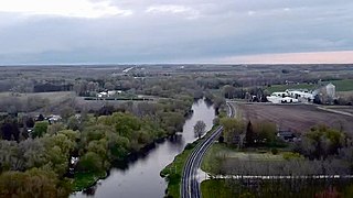
Cedar Creek
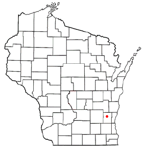
According to the United States Census Bureau, the Town of Cedarburg has a total area of 25.8square miles (66.9km2), of which, 25.6square miles (66.3km2) of it is land and 0.2square miles (0.6km2) of it (0.93%) is water.
The town is located in the Southeastern Wisconsin glacial till plains that were created by the Wisconsin glaciation during the most recent ice age. The soil in area is a mixture of well-draining material, loess, and loam, which all overlie a layer of glacial till. The town has some Silurianlimestone deposits, including land around the City of Cedarburg. The early settlers utilized the area's limestone as a building material, and some mid-19th-century limestone structures still stand today.[15]
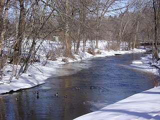
Cedar Creek runs through the town from the Town of Jackson. It joins the Milwaukee River downstream in Grafton. The creek's lower reaches in the City of Cedarburg have high levels of PCB contamination, and in 1993, the Wisconsin Department of Natural Resources believed that Cedar Creek had the highest PCB contamination level in the state.[16] Despite cleanup efforts, the Wisconsin DNR advises against eating any fish caught in the creek downstream from the Bridge Road dam.[17] Mole Creek, a tributary of the Milwaukee River, flows through the Town of Cedarburg's Pleasant Valley Nature Park.[15]
Before white settlers arrived in the area, much of the Cedarburg area was an upland forest dominated by American beech and sugar maple trees. There were also white cedars growing along Cedar Creek. Much of the original forest was cleared to prepare the land for agriculture, and in the 21st century much of the town's land continues to be used for agriculture.[15]
As land development continues to reduce wild areas, wildlife is forced into closer proximity with human communities like Cedarburg. Large mammals, including white-tailed deer, coyotes, and red foxes can be seen in the town. There have been infrequent sightings of black bears in Ozaukee County communities, including a 2005 report of a bear in a Cedarburg city park.[18] Many birds, including sandhill cranes and wild turkeys are found in and around the town.[19] The Wisconsin Bird Conservation Initiative considers the Cedarburg Bog, located north of the town in the Town of Saukville, to be a Wisconsin Important Bird Area.[15][14] The rare Goldenseal plant grows in a woodland on the northern boundary between the town and the City of Cedarburg.[15]
As of the census[2] of 2010, there were 5,760 people, 2,055 households, and 1,755 families residing in the town. The population density was 225 people per square mile (86.9/km2). There were 2,127 housing units at an average density of 83.1 per square mile (32.1/km2). The racial makeup of the town was 98.0% White, 0.4% Black or African American, 0.1% Native American, 0.7% Asian, 0.2% from other races, and 0.6% from two or more races. 1.3% of the population were Hispanic or Latino of any race.
There were 2,055 households, out of which 36.0% had children under the age of 18 living with them, 78.5% were married couples living together, 4.4% had a female householder with no husband present, and 14.6% were nonfamily households. 11.6% of all households were made up of individuals, and 5.4% had someone living alone who was 65 years of age or older. The average household size was 2.80 and the average family size was 3.05.
The median age was 45.1 years, with 26.6% of the population under the age of 18 and 13.5% aged 65 or older.
The 2017 American Community Survey estimated the median household income at $96,771 per year, with a median per capita income of $51,185; 3.9% of people in the town were estimated to have income below the poverty level.
Law and government
The Town of Cedarburg is governed by an elected town board, comprising a chairman and four town supervisors. The current town chairman is David Salvaggio.[21]
Cedarburg's volunteer fire department was founded in 1866. There are two active fire stations in the community: one on Mequon Avenue in the City of Cedarburg, and the other on Covered Bridge Road in the Town of Cedarburg. Jeffrey Vahsholtz has served as fire chief since 2014.[23]
Most of the Town of Cedarburg's public school students are served by the Cedarburg School District. The district has three elementary schools, serving grades kindergarten through fifth grade: Parkview Elementary, Thorson Elementary, and Westlawn Elementary. Each elementary school serves areas of the town and the city. Webster Middle School serves the entire district for grades six through eight, and Cedarburg High School serves grades nine through twelve. Some residents living in the northeastern part of the town are served by the Grafton School District.
The district is governed by a seven-member elected school board, which meets on the third Thursday of each month at Cedarburg High School. The district also a superintendent. Todd Bugnacki, the current superintendent, has held the position since 2015.[25]
The district frequently appears on lists of the best schools in the state.[26]
Transportation
Cedarburg is located west of Interstate 43, which passes through the Town of Grafton. Wisconsin Highway 60 also runs through the town.
Cedarburg has limited public transit compared with larger cities. Ozaukee County and the Milwaukee County Transit System run the Route 143 commuter bus, also known as the "Ozaukee County Express," to Milwaukee via Interstate 43. The bus stops at the park-and-ride lot by Cedarburg's interstate on- and offramps. The bus operates eight trips to Milwaukee on weekday mornings and nine trips from Milwaukee on weekday evenings, corresponding to peak commute times.[27][28] Ozaukee County Transit Services' Shared Ride Taxi is the public transit option for traveling to sites not directly accessible from the interstate. The taxis operate seven days a week and make connections to Washington County Transit and Milwaukee County Routes 12, 49 and 42u.[27][29]
Parks and recreation
The historic Cedarburg covered bridge in Ozaukee County's Covered Bridge ParkThe interior of the Cedarburg covered bridge
The Town of Cedarburg maintains seven public parks, including three canoe access points on Cedar Creek, and the town also has parks maintained by Ozaukee County and the Ozaukee Washington Land Trust. The town recreation department offers little league baseball, flag football, track and field, and soccer.[30]
Town parks
Cedar Creek Farms Canoe Launch: A 0.33-acre park on Cedar Creek with a paved parking lot and a wooden canoe launch platform, which functions best in spring when water levels are at their peak.
Creekside Park: A 0.56-acre park with a canoe access point and gravel parking area. The parks wooded and riparian areas also provide opportunities for birdwatching.
Hamilton Park: Located in the Hamilton Historic District, this 1-acre park has picnic tables and an historical marker.
Krohn Park: An 11-acre park on the banks of Cedar Creek, alone Covered Bridge Road. The park has walking trails, a canoe access point, and an historical marker about the 19th century Kaehlers Mill settlement which was located at the site.
Orthopaedic Hospital of Wisconsin Fields: A 5.26-park outdoor athletic area with two baseball fields.
Pleasant Valley Park: An 88-acre park co-owned by the Town of Cedarburg and the City of Cedarburg on the site of a former landfill. Visitors can experience a variety of biomes, including woodlands, prairies, and a bog, as well as landforms including glacially formed kettles and Mole Creek. The park has a parking lot, a picnic shelter with restrooms, a Boy Scout campground, mountain biking trails, walking trails, and boardwalks.[31][32]
County and land trust parks
Covered Bridge Park: A 12-acre park maintained by Ozaukee County and contains the last 19th century covered bridge in Wisconsin, which spans Cedar Creek. Constructed in 1876, the bridge was once one of over 40 covered bridges in the state and was used for wagon and automobile traffic until 1962. It was listed on the National Register of Historic Places in 1973 and is now used only for pedestrian traffic.[33] The park also has picnic and fishing areas and canoe access points.[34]
Cedarburg Environmental Study Area: A 38-acre nature area maintained by the Ozaukee Washington Land Trust and containing wetlands, ponds, open meadow, conifer forests and mixed hardwood forests with a diversity of wildlife and opportunities for birdwatching.[35]
Notable people
Paul Clement, United States Solicitor General, was born in the town
Ozaukee County is a county in the U.S. state of Wisconsin. As of the 2020 census, the population was 91,503. Its county seat is Port Washington. Ozaukee County is included in the Milwaukee–Waukesha–West Allis, WI Metropolitan Statistical Area.
Mequon is the largest city in Ozaukee County, in the U.S. state of Wisconsin, and the third-largest city in Wisconsin by land area. Located on Lake Michigan's western shore with significant commercial developments along Interstate 43, the community is a suburb in the Milwaukee metropolitan area. Despite being an incorporated city, approximately half of Mequon's land is undeveloped and agriculture plays a significant role in the local economy. At the time of the 2020 census the population was 25,142.
Thiensville is a village in Ozaukee County, Wisconsin, United States. Located on the west bank of a bend in the Milwaukee River, the community is bordered on all sides by the City of Mequon and is a suburb in the Milwaukee metropolitan area. The population was 3,235 at the 2010 census.
Belgium is a town in Ozaukee County, Wisconsin, United States. The population was 1,513 at the 2000 census. The Village of Belgium is surrounded on all sides by the town, and the unincorporated communities of Decker, Holy Cross, Lake Church, and Sauk Trail Beach are located in the town, as is the ghost town of Stonehaven. The unincorporated community of Dacada is also partially located in the town.
Belgium is a village in Ozaukee County, Wisconsin, United States. Located along Interstate 43, the village is one of the northernmost communities in the Milwaukee metropolitan area. The population was 2,245 at the 2010 census.
Cedarburg is a city in Ozaukee County, Wisconsin, United States. Located about 20 miles (32 km) north of Milwaukee and in close proximity to Interstate 43, it is a suburban community in the Milwaukee metropolitan area. The city incorporated in 1885, and at the time of the 2020 census the population was 12,121.
Fredonia is a village in Ozaukee County, Wisconsin, United States. Located on the Milwaukee River, the village is in the Milwaukee metropolitan area. The population was 2,160 at the 2010 census.
Fredonia is a town in Ozaukee County, Wisconsin, United States. The population was 2,903 at the 2000 census. The Village of Fredonia is surrounded by the town. The unincorporated communities of Little Kohler and Waubeka are also located in the town.
The Town of Grafton is a town located in Ozaukee County, Wisconsin, United States, and is in the Milwaukee metropolitan area. The town was created in 1846 and at the time of the 2020 Census had a population of 4,157.
Grafton is a village in Ozaukee County, Wisconsin, United States. Located about 20 miles (32 km) north of Milwaukee and in close proximity to Interstate 43, it is a suburban community in the Milwaukee metropolitan area. The village incorporated in 1896, and at the time of the 2020 census the population was 12,094.
Port Washington is a town in Ozaukee County in the U.S. state of Wisconsin. It surrounds the northern and western side of the city of Port Washington. As of the 2020 census, the town population was 1,538. The unincorporated communities of Druecker and Knellsville are also located in the town.
Saukville is a town in Ozaukee County, Wisconsin, United States. The Village of Saukville is located in the town's southeast quadrant. The population was 1,755 at the 2000 census.
Saukville is a village in Ozaukee County, Wisconsin, United States. Located on the Milwaukee River with a district along Interstate 43, the community is a suburb in the Milwaukee metropolitan area. The population was 4,258 at the 2020 census.
West Bend is a town in Washington County, Wisconsin, United States. The population was 4,834 at the 2000 census. The City of West Bend is located partially within the town. The unincorporated community of Nabob is located in the town.
West Bend is a city in and the county seat of Washington County, Wisconsin, United States. As of the 2020 census, the population was 31,752.
Cedar Creek is a 53-kilometre-long (33 mi) stream in southeastern Wisconsin in the United States. The Cedar Creek watershed is a 330 km2 (127 mi2) sub-basin of the larger Milwaukee River watershed.
Hamilton is an unincorporated community located in the Town of Cedarburg, Ozaukee County, Wisconsin, United States. Much of the community is part of the Hamilton Historic District, a site listed on the National Register of Historic Places. The NRHP-listed Concordia Mill is also located in the community.
The Covered Bridge in Cedarburg, Ozaukee County, Wisconsin, United States, is one of the last remaining covered bridges in that state, which once had about 40 covered bridges. Built in 1876 to cross Cedar Creek, the bridge is 120 feet (37 m) long and is made of pine with oak lattices. It was listed on the National Register of Historic Places in 1973 and is now used only for pedestrian traffic.
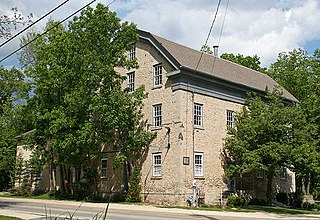
The Hilgen and Wittenberg Woolen Mill is a former textile factory in Cedarburg, Wisconsin. Built in 1864, the mill was one of many wool- and flax-processing factories that opened during the American Civil War, due to a shortage of cotton textiles formerly supplied by southern states. The mill produced yarns, blankets, and flannels, and was the largest woolen mill west of Philadelphia in the 19th century. The mill closed in 1968 and has since become a commercial complex called the "Cedar Creek Settlement," containing restaurants and stores.
The Columbia Historic District is a neighborhood in Cedarburg, Wisconsin, that is listed on the National Register of Historic Places. At the time the district was listed on the register, its contributing properties included 128 historic homes, one church, and eighty-seven historic outbuildings, including garages and barns, all constructed between 1844 and 1938. The district also contained several dozen buildings that do not contribute to the historic district, including modern homes from the post-war era as well as modern garages and other additions to historic properties.
↑ Gerwing, Anselm J. (Summer 1964). "The Chicago Indian Treaty of 1833". Journal of the Illinois State Historical Society. 57 (2): 117–142. ISSN0019-2287. JSTOR40190019.
This page is based on this Wikipedia article Text is available under the CC BY-SA 4.0 license; additional terms may apply. Images, videos and audio are available under their respective licenses.