Thiensville, Wisconsin

Last updated
Thiensville
Thiensville Main St May09.jpg
Ozaukee County Wisconsin Incorporated and Unincorporated areas Thiensville Highlighted.svg
Location of Thiensville in Ozaukee County, Wisconsin.
USA Wisconsin location map.svg
Red pog.svg
Thiensville
Location within Wisconsin
Coordinates: 43°14′13″N87°58′48″W / 43.23694°N 87.98000°W / 43.23694; -87.98000 Coordinates: 43°14′13″N87°58′48″W / 43.23694°N 87.98000°W / 43.23694; -87.98000
Country Flag of the United States.svg  United States
State Flag of Wisconsin.svg  Wisconsin
County Ozaukee
Settledc.1837
Incorporated 1910;112 years ago (1910)
Government
  Village PresidentVan A. Mobley
   Administrator Colleen Landisch-Hansen
   Clerk/treasurer Amy Langlois
   Village board
Trustees
  • Angelina Apostolos
  • Jennifer Abraham
  • Rob Holyoke
  • Kenneth C. Kucharski
  • David A. Lange
  • Kristina Eckert
Area
[1]
  Total1.08 sq mi (2.79 km2)
  Land1.04 sq mi (2.69 km2)
  Water0.04 sq mi (0.10 km2)
Elevation
[2]
676 ft (206 m)
Population
 (2010) [3]
  Total3,235
  Estimate 
(2019) [4]
3,125
  Density3,010.60/sq mi (1,162.67/km2)
Time zone UTC-6 (Central (CST))
  Summer (DST) UTC-5 (CDT)
Area code(s) 262
FIPS code 55-79475 [5]
GNIS feature ID1575351 [2]
Website village.thiensville.wi.us

Thiensville is a village in Ozaukee County, Wisconsin, United States. Located on the west bank of a bend in the Milwaukee River, the community is bordered on all sides by the City of Mequon and is a suburb in the Milwaukee metropolitan area. The population was 3,235 at the 2010 census.

Contents

Thiensville was the site of a Potawatomi village in the early 19th century before white settlers began arriving in the 1830s and 1840s. Many of the community's earliest settlers were German immigrants who were members of freethinker societies. One prominent freethinker was Joachim Heinrich Thien, for whom the village is named. Thien played a significant role in the Town of Mequon's early politics and organized the Thiensville Volunteer Fire Department. The freethinkers were opposed to organized religion and actively prevented churches from being established in the community for the first eight decades of its history. Thiensville grew and prospered in the late 1800s when it became a railway stop; the community became more urban with stores, mills and services for farmers in the rural Town of Mequon. The Village of Thiensville formally incorporated in 1910.

Both Mequon and Thiensville experienced significant development during the suburbanization that followed World War II, with Mequon incorporating as a city in 1957. The two communities have close ties, with a shared chamber of commerce, library, and school district. In July 2005, CNNMoney.com ranked Thiensville and Mequon 19th on its list of the 100 Best Places to Live in the United States. [6]

History

In the early 19th century, the Potawatomi lived on the west bank of the Milwaukee River and had a village in present-day Thiensville, located on Pigeon Creek, north of Freistadt Road. They surrendered their land to the United States federal government in 1833 through the 1833 Treaty of Chicago, which (after being ratified in 1835) required them to leave the area by 1838. [7] [8]

The first permanent white settlers arrived in the mid-1830s from New York, England, and Ireland. One of the first settlers was John Weston, who settled near present-day Thiensville in 1837 and served as the first postmaster of the Town of Mequon. The first Germans arrived in 1839, and in the 1840s Germans became the largest ethnic group in Thiensville, the Town of Mequon, and Ozaukee County. [9]

Joachim Heinrich Thien moved to the area in 1842 from Oldenburg, Prussia, and helped design a plan for the settlement that would become Thiensville. A year later he employed a group of Native American laborers to construct a dam and a canal on the Milwaukee River. He then built a sawmill and a store. Thien hosted the first town meeting for the Town of Mequon in 1846, [10] and in 1857 he established the volunteer fire department and served as its first captain.

Thien was a freethinker, as were many of the early German settlers. The influence of the freethinker societies kept formal churches out of the village until 1919, when St. Cecilia Catholic Church was built. [11]

Thiensville grew in part because of its location on the Chicago, Milwaukee & St. Paul Railway, which was constructed in the early 1870s. In the late 19th and early 20th centuries, Thiensville was one of the most concentrated communities in the Town of Mequon. While most of Mequon was quite rural, Theinsville functioned as a downtown area with stores, mills, and professional services. The Village of Theinsville incorporated in 1910 with a population of 289. [12] [13]

In 1945, eighty German prisoners of war from Camp Fredonia in Little Kohler, Wisconsin were contracted to work at the Herbert A. Nieman Canning Company in the village to make up for the loss of labor due to local men fighting in World War II. [14] German prisoners from Camp Rockfield in Rockfield, Wisconsin, (located in present-day Germantown) also worked at the Fromm Bros., Nieman & Co. Fox Ranch in northern Mequon. [15]

In the 20th century, Mequon and the village of Theinsville developed a close relationship, [16] with a shared school district, [17] chamber of commerce, [18] and library. [19]

Geography

Thiensville is located at 43°14′13″N87°58′48″W / 43.23694°N 87.98000°W / 43.23694; -87.98000 (43.236806, -87.979951). [20] According to the United States Census Bureau, the village has a total area of 1.10 square miles (2.85 km2), of which, 1.09 square miles (2.82 km2) of it is land and 0.01 square miles (0.03 km2) is water. [21]

Many of the houses in Thiensville's Green Bay Road Historic District date to the 1890s and early 1900s. Green Bay Rd Thiensville WI May-09.jpg
Many of the houses in Thiensville's Green Bay Road Historic District date to the 1890s and early 1900s.

The Village of Thiensville is an enclave, surrounded by the City of Mequon on all sides. [22] The village is located on the north and west bank of a bend in the Milwaukee River. Pigeon Creek also flows through downtown Thiensville into the river, with the confluence near the old village hall at the intersection of Main Street and Green Bay Road. There is a dam on the Milwaukee River, upstream from the confluence of the river and the creek. [23]

The village is located in the Southeastern Wisconsin glacial till plains that were created by the Wisconsin glaciation during the most recent ice age. The village is south of the Devonian Thiensville formation, a large limestone deposit lying mostly below the soil with the exception of an exposed rock face at the Cedarburg Road cut in northern Mequon. The Wisconsin Department of Natural Resources considers the eastern part of Thiensville to be in the Central Lake Michigan Coastal ecological landscape, while the western part of the village is in the Southern Lake Michigan Coastal ecological landscape. [23] Before white settlers arrived in the area, the area was an upland forest dominated by American beech and sugar maple trees. While some areas of Mequon have remained undeveloped, most of Thiensville has been developed and little-to-none of the old growth forest remains. [23]

The region struggles with many invasive species, including the emerald ash borer, common carp, reed canary grass, the common reed, purple loosestrife, garlic mustard, Eurasian buckthorns, and honeysuckles. [24]

Demographics

Historical population
CensusPop.
1920 334
1930 50049.7%
1940 5000.0%
1950 89779.4%
1960 2,507179.5%
1970 3,18226.9%
1980 3,3415.0%
1990 3,301−1.2%
2000 3,254−1.4%
2010 3,235−0.6%
2019 (est.)3,125 [4] −3.4%
U.S. Decennial Census [25]

2010 census

As of the census [3] of 2010, there were 3,235 people, 1,532 households, and 865 families living in the village. The population density was 2,967.9 inhabitants per square mile (1,145.9/km2). There were 1,644 housing units at an average density of 1,508.3 per square mile (582.4/km2). The racial makeup of the village was 93.3% White, 1.7% African American, 0.4% Native American, 2.1% Asian, 0.5% from other races, and 1.9% from two or more races. Hispanic or Latino of any race were 2.8% of the population.

There were 1,532 households, of which 24.5% had children under the age of 18 living with them, 45.6% were married couples living together, 7.7% had a female householder with no husband present, 3.2% had a male householder with no wife present, and 43.5% were non-families. 38.5% of all households were made up of individuals, and 17.6% had someone living alone who was 65 years of age or older. The average household size was 2.11 and the average family size was 2.82.

The median age in the village was 46.3 years. 20.8% of residents were under the age of 18; 5.6% were between the ages of 18 and 24; 21.5% were from 25 to 44; 31% were from 45 to 64; and 21% were 65 years of age or older. The gender makeup of the village was 45.8% male and 54.2% female.

2000 census

As of the census [5] of 2000, there were 3,254 people, 1,503 households, and 933 families living in the village. The population density was 2,964.7 people per square mile (1,142.2/km2). There were 1,570 housing units at an average density of 1,430.4 per square mile (551.1/km2). The racial makeup of the village was 96.56% White, 0.74% African American, 0.06% Native American, 1.26% Asian, 0.18% from other races, and 1.20% from two or more races. Hispanic or Latino of any race were 1.04% of the population.

There were 1,503 households, out of which 25.6% had children under the age of 18 living with them, 50.7% were married couples living together, 9.0% had a female householder with no husband present, and 37.9% were non-families. 33.3% of all households were made up of individuals, and 14.8% had someone living alone who was 65 years of age or older. The average household size was 2.17 and the average family size was 2.77.

In the village, the population was spread out, with 20.7% under the age of 18, 5.0% from 18 to 24, 27.8% from 25 to 44, 25.9% from 45 to 64, and 20.6% who were 65 years of age or older. The median age was 43 years. For every 100 females, there were 86.6 males. For every 100 females age 18 and over, there were 81.2 males.

The median income for a household in the village was $55,962, and the median income for a family was $69,286. Males had a median income of $46,088 versus $29,500 for females. The per capita income for the village was $30,748. About 1.9% of families and 2.7% of the population were below the poverty line, including 2.1% of those under age 18 and 2.1% of those age 65 or over.

Culture

Events

Thiensville hosts several annual public events and celebrations, including a Memorial Day parade, family-friendly "Fun Before the Fourth" the Saturday before Independence Day, and a public Christmas Tree lighting. [23] The village also hosts a farmers market in Village Park (299 Elm St.) every Tuesday from June through October, 9 a.m. to 3:00 p.m. [26]

Each June, the local Lions Club hosts an annual Lionfest, with a softball tournament, bingo, live entertainment, carnival rides, a chicken dinner, and a car show. [27]

Frank L. Weyenberg Library

The Frank L. Weyenberg Library is a public library serving Mequon and Thiensville. In addition to its collection of physical media, the library provides patrons with digital resources and meeting space. In 2018, the library made 307,796 loans to patrons. The library is a member of the Monarch Library System, comprising thirty-one libraries in Ozaukee, Sheboygan, Washington, and Dodge counties. [28]

Religion

Many of Thiensville's founders were German immigrants who were members of freethinker societies. They actively worked to keep organized churches out of the community, and succeeded for the first eight decades of the village's existence. When St. Cecilia Catholic Church and School was built in 1919, it was the first church in the village. [11] St. Cecilia merged with St. James Catholic Church of Mequon in 1984 to form Lumen Christi Catholic Church and School. Services were held in Thiensville until 2019, when a new, larger facility was completed in nearby Mequon. [29]

As of 2020, Grace Lutheran Church, which is affiliated with the Evangelical Lutheran Church in America [30] and Christ Alone Evangelical Lutheran Church's North Campus, which is affiliated with the Wisconsin Evangelical Lutheran Synod, are located in the village. Christ Alone also operates a parochial school serving students from kindergarten through eighth grade in the village. [31]

Law and government

Thiensville is organized as a village governed by an elected board of trustees, comprising a village president and six trustees, all of whom are elected for three-year terms. The current president is Van Mobley, a Concordia University Wisconsin professor of history and economics who was first elected president in April 2012. The board meets on the third Monday of each month at 6 p.m. in the Thiensville Village Hall. [32] Since 1984, the village's day-to-day operations have been managed by a full-time city administrator. [33]

As part of Wisconsin's 6th congressional district, Thiensville is represented by Glenn Grothman (R) in the United States House of Representatives, and by Ron Johnson (R) and Tammy Baldwin (D) in the United States Senate. Alberta Darling (R) represents Thiensville in the Wisconsin State Senate, and Deb Andraca (D) represents Thiensville in the Wisconsin State Assembly. [34]

FromTo Village President [35]
19101912John F. Gierach
19121917John E. Mueller
19171920Charles A. Maas
19201922Charles Friedrich
19221927Charles A. Maas
19271935Julius W. Schaefer
19351945Dr. Alfred H. Carthaus
19451955Theodore O. Liebscher
19551959Harold H. Roethel
19591961Edward Langley
19611967Theodore O. Liebscher
19671968William T. Flynn
19681971Richard R. Sitman
19711977Ned A. Kellner
19771987Robert C. Warber
19871987William C. Roselle
19871989Donald A. Molyneux
19891991John V. Kitzke
19911995Roy Wetzel
19952006Donald A. Molyneux
20062012Karl V. Hertz
2012presentVan Mobley

Thiensville Fire Department

The old Village Hall and Fire Station, built in 1914, is now home to the William F. Rausch Fire Museum operated by Thiensville's volunteer fire department. FRONT (WEST) AND SOUTH SIDE, PERSPECTIVE VIEW - Thiensville Village Hall, 101 Green Bay Road, Thiensville, Ozaukee County, WI HABS WIS,45-THIVI,1-5.tif
The old Village Hall and Fire Station, built in 1914, is now home to the William F. Rausch Fire Museum operated by Thiensville's volunteer fire department.

Thiensville's volunteer fire department was organized in 1857 by village founder Joachim Heinrich Thien. Brian Reiels currently serves as fire chief. The department has one fire station, located at 250 Elm Street, and also maintains the William F. Rausch Fire Museum in the historic 1914 Fire Department & Village Hall on Main Street. [36]

Thiensville Police Department

Thiensville's full-time police department was established in 1967. Prior to that, the village had a part-time village constable or village marshal. The department employs seven full-time sworn officers, one civilian administrator, and fourteen reserve officers. [37] Curt Kleppin has served as police chief since 2018. [38]

Education

Thiensville's public schools are operated by the Mequon-Thiensville School District. The villages students attend two of the district's three elementary schools, serving grades kindergarten through fifth grade. Students in northern and eastern Thiensville attend Oriole Lane Elementary, while students from southwestern Thiensville attend Wilson Elementary. All students from Thiensville attend Steffen Middle School for sixth through eighth grades and Homestead High School for grades nine through twelve. [39] In 2009, Homestead was ranked by BusinessWeek magazine as the state's top high school. [40] The school's mascot is a Highlander. [41]

Christ Alone Evangelical Lutheran Church also operates a parochial school in Thiensville for students from kindergarten through eight grade. [31]

Transportation

Thiensville has limited public transit compared with larger communities. Ozaukee County Transit Services' Shared Ride Taxi is the public transit option for traveling to sites in the county. The taxis operate seven days a week and make connections to Washington County Transit and Milwaukee County Routes 12, 49 and 42u. [42] [43]

The village has sidewalks in most areas, and the Ozaukee Interurban Trail runs north-south through the community, connecting Thiensville to the neighboring communities of Mequon as well as Cedarburg in the north and Brown Deer in the south, where the trail connects to Milwaukee County's Oak Leaf Trail. The Ozaukee Interurban Trail continues north to Oostburg in Sheboygan County. The trail was formerly an interurban passenger rail line that ran from Milwaukee to Sheboygan. The train was in operation from 1907 to 1948, when it fell into disuse following World War II. The old rail line was converted into the present recreational trail in the 1990s.

The Wisconsin Central Ltd. railroad, a subsidiary of the Canadian National Railway, operates a freight rail line parallel to the Ozaukee Interurban Trail in the village. [44] Despite the role that railways played in Thiensville's early development, the village currently does not have passenger train service.

Parks and recreation

The Village of Thiensville maintains Molyneux Park on the Milwaukee River in downtown Thiensville, and the Mequon and Thiensville Rotary clubs maintain a pedestrian riverwalk in the village. The village also coordinates with Mequon to organize youth sports leagues. [45]

The Ozaukee Interurban Trail runs through the City of Cedarburg, following the former route of the Milwaukee Interurban Rail Line. The southern end of the trail is at Bradley Road in Brown Deer which connects to the Oak Leaf Trail ( 43°09′48″N87°57′39″W / 43.16333°N 87.96083°W / 43.16333; -87.96083 ), and its northern end is at DeMaster Road in the Village of Oostburg Sheboygan County ( 43°36′57″N87°48′08″W / 43.61583°N 87.80222°W / 43.61583; -87.80222 ).

Notable people

U.S. Representative Glenn Grothman (b. 1955) was raised in Thiensville and attended Homestead High School. Glenn Grothman official congressional photo.jpg
U.S. Representative Glenn Grothman (b. 1955) was raised in Thiensville and attended Homestead High School.

See also

Related Research Articles

<span class="mw-page-title-main">Ozaukee County, Wisconsin</span> County in Wisconsin, United States

Ozaukee County is a county in the U.S. state of Wisconsin. As of the 2020 census, the population was 91,503. Its county seat is Port Washington, making it one of three Wisconsin counties on Lake Michigan not to have a county seat with the same name. Ozaukee County is included in the Milwaukee–Waukesha–West Allis, WI Metropolitan Statistical Area.

Milwaukee County, Wisconsin County in Wisconsin, United States

Milwaukee County is located in the U.S. state of Wisconsin. As of the 2020 census, the population was 939,489, down from 947,735 in 2010. It is both the most populous and most densely populated county in Wisconsin, and the 45th most populous county nationwide; Milwaukee, its eponymous county seat, is also the most populous city in the state. The county was created in 1834 as part of Michigan Territory and organized the following year.

<span class="mw-page-title-main">Mequon, Wisconsin</span> City in Ozaukee County, Wisconsin

Mequon is the largest city in Ozaukee County, in the U.S. state of Wisconsin, and the third-largest city in Wisconsin by land area. Located on Lake Michigan's western shore with significant commercial developments along Interstate 43, the community is a suburb in the Milwaukee metropolitan area. Despite being an incorporated city, approximately half of Mequon's land is undeveloped and agriculture plays a significant role in the local economy. At the time of the 2010 census the population was 23,132.

Bayside, Wisconsin Village in Milwaukee and Ozaukee counties, Wisconsin

Bayside is a village in Milwaukee and Ozaukee counties in the U.S. state of Wisconsin. The population was 4,482 at the 2020 census. Of this, 4,378 were in Milwaukee County, and only 104 were in Ozaukee County.

Belgium (town), Wisconsin Town in Ozaukee County, Wisconsin

Belgium is a town in Ozaukee County, Wisconsin, United States. The population was 1,513 at the 2000 census. The Village of Belgium is surrounded on all sides by the town, and the unincorporated communities of Decker, Holy Cross, Lake Church, and Sauk Trail Beach are located in the town, as is the ghost town of Stonehaven. The unincorporated community of Dacada is also partially located in the town. The ghost town of Stonehaven is also located in the town.

Belgium, Wisconsin Village in Ozaukee County, Wisconsin

Belgium is a village in Ozaukee County, Wisconsin, United States. Located along Interstate 43, the village is one of the northernmost communities in the Milwaukee metropolitan area. The population was 2,245 at the 2010 census.

<span class="mw-page-title-main">Cedarburg (town), Wisconsin</span> Town in Ozaukee County, Wisconsin

Cedarburg is a town in Ozaukee County, Wisconsin, United States, and is in the Milwaukee metropolitan area. The town was created in 1849 and at the time of the 2010 census had a population of 5,760.

<span class="mw-page-title-main">Cedarburg, Wisconsin</span> City in Ozaukee County, Wisconsin

Cedarburg is a city in Ozaukee County, Wisconsin, United States. Located about 20 miles (32 km) north of Milwaukee and in close proximity to Interstate 43, it is a suburban community in the Milwaukee metropolitan area. The city incorporated in 1885, and at the time of the 2010 census the population was 11,412.

<span class="mw-page-title-main">Fredonia, Wisconsin</span> Village in Ozaukee County, Wisconsin

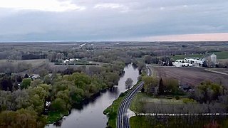
Fredonia is a village in Ozaukee County, Wisconsin, United States. Located on the Milwaukee River, the village is in the Milwaukee metropolitan area. The population was 2,160 at the 2010 census.

<span class="mw-page-title-main">Fredonia (town), Wisconsin</span> Town in Ozaukee County, Wisconsin

Fredonia is a town in Ozaukee County, Wisconsin, United States. The population was 2,903 at the 2000 census. The Village of Fredonia is surrounded by the town. The unincorporated communities of Little Kohler and Waubeka are also located in the town.

Grafton (town), Wisconsin Town in Ozaukee County, Wisconsin

Grafton is a town in Ozaukee County, Wisconsin, United States, and is in the Milwaukee metropolitan area. The town was created in 1846 and at the time of the 2010 census had a population of 4,053.

Grafton, Wisconsin Village in Ozaukee County, Wisconsin

Grafton is a village in Ozaukee County, Wisconsin, United States. Located about 20 miles (32 km) north of Milwaukee and in close proximity to Interstate 43, it is a suburban community in the Milwaukee metropolitan area. The village incorporated in 1896, and at the time of the 2010 census the population was 11,459.

Port Washington (town), Wisconsin Town in Ozaukee County, Wisconsin

Port Washington is a town in Ozaukee County in the U.S. state of Wisconsin. It surrounds the northern and western side of the city of Port Washington. As of the 2000 census, the town population was 1,631. The unincorporated communities of Druecker and Knellsville are also located in the town.

<span class="mw-page-title-main">Port Washington, Wisconsin</span> City and county seat of Ozaukee County, Wisconsin

Port Washington is the county seat of Ozaukee County in the U.S. state of Wisconsin. Located on Lake Michigan's western shore east of Interstate 43, the community is a suburb in the Milwaukee metropolitan area 27 miles north of the City of Milwaukee. The city's artificial harbor at the mouth of Sauk Creek was dredged in the 1870s and was a commercial port until the early 2000s. The population was 11,250 at the 2010 census.

Saukville (town), Wisconsin Town in Ozaukee County, Wisconsin

Saukville is a town in Ozaukee County, Wisconsin, United States. The Village of Saukville is located in the town's southeast quadrant. The population was 1,755 at the 2000 census.

<span class="mw-page-title-main">Saukville, Wisconsin</span> Village in Ozaukee County, Wisconsin

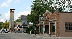
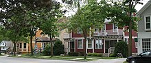
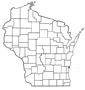
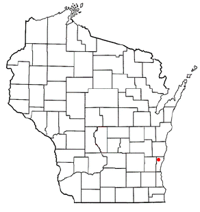
Saukville is a village in Ozaukee County, Wisconsin, United States. Located on the Milwaukee River with a district along Interstate 43, the community is a suburb in the Milwaukee metropolitan area. The population was 4,451 at the 2010 census.

<span class="mw-page-title-main">Germantown, Washington County, Wisconsin</span> Town in Washington County, Wisconsin

Germantown is a town in Washington County, Wisconsin, United States. The population was 278 at the 2000 census. It is surrounded by the village of Germantown.

The Milwaukee metropolitan area is a major metropolitan area located in Southeastern Wisconsin, consisting of the city of Milwaukee and the surrounding area. There are several definitions of the area, including the Milwaukee–Waukesha–West Allis metropolitan area and the Milwaukee–Racine–Waukesha combined statistical area. It is the largest metropolitan area in Wisconsin, and the 39th largest metropolitan area in the United States.

Ozaukee Interurban Trail

The Ozaukee - Sheboygan Interurban Trail is a roughly 40-mile (64 km) long rail trail in Ozaukee, and Sheboygan Counties, in Wisconsin. The south end of the trail is in Milwaukee County but only runs 1 mile through the county.

The Eastern Shores Library System (ESLS) was one of 17 public library systems in Wisconsin. Founded in 1987, it had 13 member libraries, with five in Ozaukee County and eight located in Sheboygan County, in addition to a bookmobile. Sheboygan's Mead Public Library served as the resource library for the system. The last director of ESLS was Amy Birtell.

References

  1. "2019 U.S. Gazetteer Files". United States Census Bureau. Retrieved August 7, 2020.
  2. 1 2 "US Board on Geographic Names". United States Geological Survey. 2007-10-25. Retrieved 2008-01-31.
  3. 1 2 "U.S. Census website". United States Census Bureau . Retrieved 2012-11-18.
  4. 1 2 "Population and Housing Unit Estimates". United States Census Bureau. May 24, 2020. Retrieved May 27, 2020.
  5. 1 2 "U.S. Census website". United States Census Bureau . Retrieved 2008-01-31.
  6. "Village of Thiensville, WI". Kids Out and About Milwaukee. Retrieved 2018-11-06.
  7. "Early history of Ozaukee County, Wisconsin". University of Wisconsin-Madison Libraries. Retrieved 2020-01-03.
  8. Gerwing, Anselm J. (Summer 1964). "The Chicago Indian Treaty of 1833". Journal of the Illinois State Historical Society. 57 (2): 117–142. ISSN   0019-2287. JSTOR   40190019.
  9. "Early history of Ozaukee County, Wisconsin". University of Wisconsin-Madison Libraries. Retrieved 2020-01-03.
  10. Walter D. Corrigan, History of the Town of Mequon, Ozaukee County, Wisconsin, Brought Down to about 1870. Mequon: Mequon Club, 1950.
  11. 1 2 "Encyclopedia of Milwaukee: Village of Thiensville". University of Wisconsin-Milwaukee. Retrieved 2020-01-03.
  12. Archived July 26, 2009, at the Wayback Machine
  13. "Ozaukee County, Wisconsin - History - Thiensville Village Hall & Fire Department". Co.ozaukee.wi.us. Archived from the original on 2012-09-26. Retrieved 2013-01-17.
  14. Cowley, Betty (2002-01-01). Stalag Wisconsin: Inside WW II Prisoner-of-war Camps. Badger Books Inc. pp. 120–25. ISBN   9781878569837.
  15. Cowley, Betty (2002-01-01). Stalag Wisconsin: Inside WW II Prisoner-of-war Camps. Badger Books Inc. pp. 227–31. ISBN   9781878569837.
  16. "City of Mequon and Village of Thiensville Community Gateway Features | Mequon Wisconsin". www.ci.mequon.wi.us. Retrieved 2019-11-09.
  17. "Mequon-Thiensville School District | The Launchpad to Success". www.mtsd.k12.wi.us. Retrieved 2019-11-09.
  18. "Mequon-Thiensville Chamber of Commerce" . Retrieved April 13, 2020.
  19. "Frank L. Weyenberg Library of Mequon-Thiensville | Official Website". www.flwlib.org. Retrieved 2019-11-09.
  20. "US Gazetteer files: 2010, 2000, and 1990". United States Census Bureau. 2011-02-12. Retrieved 2011-04-23.
  21. "US Gazetteer files 2010". United States Census Bureau. Archived from the original on 2012-01-25. Retrieved 2012-11-18.
  22. "Thiensville Business Association". Thiensville Business Association. Retrieved April 24, 2020.
  23. 1 2 3 4 "Inventory of Agricultural, Natural, and Cultural Resources". Ozaukee County. Retrieved January 20, 2020.
  24. "Central Lake Michigan Coastal Ecological Landscape" (PDF). Wisconsin Department of Natural Resources. Retrieved January 20, 2020.
  25. "Census of Population and Housing". Census.gov. Retrieved June 4, 2015.
  26. "Village of Thiensville: Village Market". Village of Thiensville. Retrieved April 25, 2020.
  27. "Lionfest". Thiensville-Mequon Lions Club. Retrieved April 25, 2020.
  28. "Frank L. Weyenberg Library: 2018 Annual Report". Frank L. Weyenberg Library. Retrieved April 13, 2020.
  29. "Lumen Christi Catholic Church: About Our Parish - History". Lumen Christi Catholic Church. Retrieved April 24, 2020.
  30. "Grace Lutheran Church elca". Grace Lutheran Church. Retrieved April 24, 2020.
  31. 1 2 "Christ Alone Lutheran". Christ Alone Lutheran. Retrieved April 24, 2020.
  32. "Village of Thiensville: Board of Trustees". Village of Thiensville. Retrieved April 13, 2020.
  33. "Village of Thiensville: Administration". Village of Thiensville. Retrieved April 13, 2020.
  34. "Wisconsin State Legislature Map". Wisconsin State Legislature. Retrieved February 3, 2022.
  35. History of Thiensville Book Committee, (2010), "Village of Thiensville Centennial celebrates 100 years, 1910-2010", Thiensville, Wisconsin.
  36. "Village of Thiensville: Fire Department". Village of Thiensville. Retrieved April 25, 2020.
  37. "Village of Thiensville: Police Department". Village of Thiensville. Retrieved April 25, 2020.
  38. "Thiensville selects Kleppin". The Associated Press. Retrieved April 25, 2020.
  39. "Mequon-Thiensville School District: Attendance Maps". Mequon-Thiensville School District. Mequon-Thiensville School District. Retrieved April 25, 2020.
  40. American's Best High Schools, Bloomberg Businessweek.
  41. "Fast Facts". Homestead High School. Mequon-Thiensville School District. Archived from the original on 2016-05-05. Retrieved May 3, 2016.
  42. "MCTS Route 143: Ozaukee County Express". Wisconsin DOT. Retrieved January 21, 2020.
  43. "OCTS: Shared Ride Taxi". Ozaukee County Transit Services. Retrieved January 21, 2020.
  44. "Wisconsin Railroads and Harbors 2020" (PDF). Wisconsin DOT. Retrieved January 21, 2020.
  45. "Village of Thiensville: Parks & Recreation". Village of Thiensville. Retrieved April 25, 2020.
  46. "Glen Grothman: Biography". U.S. House of Representatives. Retrieved April 24, 2020.
  47. Film Exchange Lofts-History