Hales Corners, Wisconsin

Last updated

Hales Corners, Wisconsin
Milwaukee County Wisconsin Incorporated and Unincorporated areas Hales Corners Highlighted.svg
Location of Hales Corners in Milwaukee County, Wisconsin.
Coordinates: 42°56′29″N88°3′4″W / 42.94139°N 88.05111°W / 42.94139; -88.05111
Country Flag of the United States.svg  United States
State Flag of Wisconsin.svg  Wisconsin
County Milwaukee
Area
[1]
  Total3.20 sq mi (8.28 km2)
  Land3.19 sq mi (8.27 km2)
  Water0.01 sq mi (0.02 km2)
Elevation
[2]
781 ft (238 m)
Population
 (2020) [3]
  Total7,720
  Density2,370.61/sq mi (915.37/km2)
Time zone UTC-6 (Central (CST))
  Summer (DST) UTC-5 (CDT)
ZIP Code
53130
Area code 414
FIPS code 55-32075 [3]
GNIS feature ID1565971 [2]
Website www.halescorners.org

Hales Corners is a village in Milwaukee County, Wisconsin, United States. The population was 7,720 at the 2020 census.

Contents

History

The land in the area that would eventually encompass the Village was first claimed as French, then British, and eventually as the Northwest Territory of the United States in 1783. It was the land of the Potawatomi Indians until they were forced to move from their land in 1838. They were the dominant tribe in southeast Wisconsin with large villages. Like the Europeans that arrived later, they planted crops, but theirs were beans, squash, and corn. By engaging in the fur trade, the Potawatomi learned to speak French and English, and they eventually intermarried with the Europeans. During the 1830s and 1840s, more settlers arrived, starting with a number of New England families. Among them were three Hale families, whose lineage has been charted to England in the 1200s. Hales Corners traces its history as a Village to 1837, when Seneca Hale laid claim to land here, and its name is credited to his brother William, who became its first Postmaster in 1854. [4] Hales Corners was the site of monthly fairs begun in the mid-1800's, when the plank road between Janesville and Milwaukee passed through the village. First a gathering of horse traders, the fairs became a stock market for farmers trading pigs, cattle, and sheep. [5]

Geography

Hales Corners is located in southwestern Milwaukee County. It is bounded by Greenfield on the north, Greendale on the east, Franklin on the south, and New Berlin and Muskego in Waukesha County on the west.

According to the United States Census Bureau, the village has a total area of 3.22 square miles (8.34 km2), of which, 3.21 square miles (8.31 km2) of it is land and 0.01 square miles (0.03 km2) is water. [6] The elevation is 781 feet (238 m).

Demographics

Historical population
CensusPop.Note
1960 5,549
1970 7,77140.0%
1980 7,110−8.5%
1990 7,6237.2%
2000 7,7651.9%
2010 7,692−0.9%
2020 7,7200.4%
U.S. Decennial Census [7]

2010 census

As of the census [3] of 2010, there were 7,692 people, 3,301 households, and 2,066 families living in the village. The population density was 2,396.3 inhabitants per square mile (925.2/km2). There were 3,505 housing units at an average density of 1,091.9 per square mile (421.6/km2). The racial makeup of the village was 94.7% White, 1.0% African American, 0.5% Native American, 1.7% Asian, 0.9% from other races, and 1.2% from two or more races. Hispanic or Latino of any race were 4.3% of the population.

There were 3,301 households, of which 27.3% had children under the age of 18 living with them, 49.1% were married couples living together, 9.8% had a female householder with no husband present, 3.6% had a male householder with no wife present, and 37.4% were non-families. 31.6% of all households were made up of individuals, and 14.6% had someone living alone who was 65 years of age or older. The average household size was 2.31 and the average family size was 2.91.

The median age in the village was 43.9 years. 20.8% of residents were under the age of 18; 8.2% were between the ages of 18 and 24; 22.6% were from 25 to 44; 29.9% were from 45 to 64; and 18.5% were 65 years of age or older. The gender makeup of the village was 47.6% male and 52.4% female.

2000 census

As of the census [3] of 2000, there were 7,765 people, 3,260 households, and 2,122 families living in the village. The population density was 2,424.7 people per square mile (936.9/km2). There were 3,377 housing units at an average density of 1,054.5 per square mile (407.5/km2). The racial makeup of the village was 97.15% White, 0.22% African American, 0.49% Native American, 0.97% Asian, 0.04% Pacific Islander, 0.57% from other races, and 0.57% from two or more races. Hispanic or Latino of any race were 2.09% of the population.

There were 3,260 households, out of which 27.4% had children under the age of 18 living with them, 53.8% were married couples living together, 8.5% had a female householder with no husband present, and 34.9% were non-families. 29.1% of all households were made up of individuals, and 12.6% had someone living alone who was 65 years of age or older. The average household size was 2.35 and the average family size was 2.93.

In the village, the population was spread out, with 22.1% under the age of 18, 7.2% from 18 to 24, 28.1% from 25 to 44, 24.2% from 45 to 64, and 18.5% who were 65 years of age or older. The median age was 41 years. For every 100 females, there were 91.1 males. For every 100 females age 18 and over, there were 87.9 males.

The median income for a household in the village was $54,536, and the median income for a family was $66,136. Males had a median income of $42,175 versus $33,237 for females. The per capita income for the village was $25,354. About 0.3% of families and 2.0% of the population were below the poverty line, including 0.6% of those under age 18 and 5.0% of those age 65 or over.

Education

The Whitnall School District serves Hales Corners. [8]

Private schools:

Post-secondary:

Points of interest

Notable people

See also

Related Research Articles

<span class="mw-page-title-main">Milwaukee County, Wisconsin</span> County in Wisconsin, United States

Milwaukee County is located in the U.S. state of Wisconsin. At the 2020 census, the population was 939,489, down from 947,735 in 2010. It is both the most populous and most densely populated county in Wisconsin, and the 45th most populous county nationwide; Milwaukee, its eponymous county seat, is also the most populous city in the state. The county was created in 1834 as part of Michigan Territory and organized the following year.

<span class="mw-page-title-main">West Salem, Wisconsin</span> Village in Wisconsin, United States

West Salem is a village in La Crosse County, Wisconsin, United States, along the La Crosse River. It is part of the La Crosse-Onalaska, WI-MN Metropolitan Statistical Area. The population was 5,277 as of the 2020 census.

<span class="mw-page-title-main">Cleveland (village), Wisconsin</span> Village in Wisconsin, United States

Cleveland is a village in Manitowoc County, Wisconsin, United States. The population was 1,579 at the 2020 census.

<span class="mw-page-title-main">Greendale, Wisconsin</span> Village in Wisconsin, United States

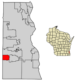
Greendale is a village in Milwaukee County, Wisconsin, United States. The population was 14,854 at the 2020 census. Greendale is located southwest of Milwaukee, Wisconsin, and is a part of the Milwaukee metropolitan area. A planned community, it was established by the United States government during the Great Depression.

<span class="mw-page-title-main">River Hills, Wisconsin</span> Village in Milwaukee County, Wisconsin

River Hills is a village in Milwaukee County, Wisconsin, United States. The population was 1,602 at the 2020 census.

<span class="mw-page-title-main">West Milwaukee, Wisconsin</span> Village in Wisconsin, United States

West Milwaukee is a village in Milwaukee County, Wisconsin, United States, which is located in the center of the county approximately a mile south of American Family Field. The population was 4,114 at the 2020 census.

<span class="mw-page-title-main">Cashton, Wisconsin</span> Village in Wisconsin, United States

Cashton is a village in Monroe County, Wisconsin, United States. The population was 1,158 at the 2020 census.

<span class="mw-page-title-main">Union Grove, Wisconsin</span> Village in Wisconsin, United States

Union Grove is a village in Racine County, Wisconsin, United States. The population was 4,806 at the 2020 census.

<span class="mw-page-title-main">West Baraboo, Wisconsin</span> Village in Wisconsin, United States

West Baraboo is a village along the Baraboo River in Sauk County, Wisconsin, United States. The population was 1,627 at the 2020 census. It is part of the Baraboo micropolitan statistical area.

<span class="mw-page-title-main">Waldo, Wisconsin</span> Village in Wisconsin, United States

Waldo is a village along the Onion River in Sheboygan County, Wisconsin, United States. The population was 503 at the 2010 census. It has a post office with ZIP code 53093. It is included in the Sheboygan, Wisconsin Metropolitan Statistical Area.

<span class="mw-page-title-main">Butler, Waukesha County, Wisconsin</span> Village in Wisconsin, United States

Butler is a village in Waukesha County, Wisconsin, United States. The population was 1,787 at the 2020 census.

<span class="mw-page-title-main">Lannon, Wisconsin</span> Village in Wisconsin, United States

Lannon is a village in Waukesha County, Wisconsin, United States. The population was 1,355 at the 2020 census. Lannon is a part of the Milwaukee metropolitan area.

<span class="mw-page-title-main">Oconomowoc Lake, Wisconsin</span> Village in Wisconsin, United States

Oconomowoc Lake is a village in Waukesha County, Wisconsin, United States. Located just outside the City of Oconomowoc, the village includes the residential area encircling Oconomowoc Lake.

<span class="mw-page-title-main">Summit, Waukesha County, Wisconsin</span> Village in Wisconsin, United States

Summit is a village in Waukesha County, Wisconsin, United States. The population was 4,784 at the 2020 census. The former unincorporated communities of Summit Center, Summit Corners, and Waterville are located in the village.

<span class="mw-page-title-main">Sussex, Wisconsin</span> Village in Wisconsin, United States

Sussex is a village in Waukesha County, Wisconsin, United States, about 19 miles (31 km) northwest of Milwaukee and 9 miles (14 km) north of Waukesha. The village is 7.24 square miles (19 km2) at an elevation of 930 feet. The population was 11,487 at the 2020 census. It is part of the Milwaukee metropolitan area.

<span class="mw-page-title-main">Newburg, Wisconsin</span> Village in Ozaukee and Washington counties, Wisconsin

Newburg is a village in Ozaukee and Washington counties in the U.S. state of Wisconsin. The population was 1,254 at the 2010 census. Of this, 1,157 were in Washington County, and only 97 were in Ozaukee County.

<span class="mw-page-title-main">New Holstein, Wisconsin</span> City in Wisconsin, United States

New Holstein is a city in Calumet County in the U.S. state of Wisconsin. The population was 2,891 as of 2024. The city is located within the Town of New Holstein.

<span class="mw-page-title-main">Sullivan, Wisconsin</span> Village in Wisconsin, United States

Sullivan is a village in Jefferson County, Wisconsin, United States. The population was 651 at the 2020 census. The village is located within the Town of Sullivan, and is known to residents of southern Wisconsin including the Madison and Milwaukee metro areas as the location of the National Weather Service forecast office MKX, although its mailing address is in nearby Dousman.

<span class="mw-page-title-main">Pewaukee, Wisconsin</span> City in Wisconsin, United States

Pewaukee is a city in Waukesha County, Wisconsin. The population was 15,914 at the 2020 census. The Village of Pewaukee, which was incorporated out of the town before it incorporated as a city, is surrounded by the city.

<span class="mw-page-title-main">Franklin, Milwaukee County, Wisconsin</span> City in Milwaukee

Franklin is a city in Milwaukee County, Wisconsin, United States. It is a suburb of Milwaukee with a population of 36,816 as of the 2020 census.

References

  1. "2019 U.S. Gazetteer Files". United States Census Bureau. Retrieved August 7, 2020.
  2. 1 2 "US Board on Geographic Names". United States Geological Survey. October 25, 2007. Retrieved January 31, 2008.
  3. 1 2 3 4 "U.S. Census website". United States Census Bureau . Retrieved January 31, 2008.
  4. "Hales Corners Village History". Hales Corners Historical Society. Retrieved November 3, 2021.
  5. Hales Corners (2nd ed.). Grey House Publishing. 2010. p. 264. Retrieved November 3, 2021 via Gale eBooks.{{cite book}}: |work= ignored (help)
  6. "US Gazetteer files 2010". United States Census Bureau . Retrieved November 18, 2012.
  7. "Census of Population and Housing". Census.gov. Retrieved June 4, 2015.
  8. "About Whitnall Archived July 12, 2014, at the Wayback Machine ." Whitnall School District. Retrieved on April 19, 2014.
  9. ":: The Hales Corners Chamber of Commerce ::". HalesCornersChamber.org. Retrieved February 4, 2017.
  10. Kochis, Michael. "index". HistoricHalesCorners.org. Retrieved February 4, 2017.
  11. "Hales Corners Library Home page". mcfls.org. Retrieved February 4, 2017.
  12. St. Mary Catholic Church
  13. Kochis, Michael. "HCHS4". HistoricHalesCorners.org. Archived from the original on July 18, 2014. Retrieved February 4, 2017.