Nashotah, Wisconsin

Last updated

Nashotah, Wisconsin
Nashotah.jpg
Waukesha County Wisconsin Incorporated and Unincorporated areas Nashotah Highlighted.svg
Location of Nashotah in Waukesha County, Wisconsin.
Coordinates: 43°5′41″N88°24′2″W / 43.09472°N 88.40056°W / 43.09472; -88.40056
Country Flag of the United States.svg  United States
State Flag of Wisconsin.svg  Wisconsin
County Waukesha
Government
  TypeVillage Board
(President - Trustees)
  PresidentRichard H. Lartz
Area
[1]
  Total1.66 sq mi (4.31 km2)
  Land1.64 sq mi (4.24 km2)
  Water0.03 sq mi (0.07 km2)
Elevation
[2]
942 ft (287 m)
Population
 (2020) [3]
  Total1,321
  Density829.97/sq mi (320.41/km2)
Time zone UTC-6 (Central (CST))
  Summer (DST) UTC-5 (CDT)
FIPS code 55-55550 [4]
GNIS feature ID1570108 [2]
Website www.nashotah-wi.gov

Nashotah is a village in Waukesha County, Wisconsin, United States. The population was 1,321 at the 2020 census. The village took its name from the nearby Nashotah Lakes. [5]

Contents

Education

Nashotah House, a seminary of The Episcopal Church, is in Nashotah. Lake Country Christian Academy, a private grade school (now closed), was also located in Nashotah.

Geography

Nashotah is located at 43°5′41″N88°24′2″W / 43.09472°N 88.40056°W / 43.09472; -88.40056 (43.094705, -88.400658); [6] in the Lake Country area of Waukesha County.

According to the United States Census Bureau, the village has a total area of 1.70 square miles (4.40 km2), of which, 1.67 square miles (4.33 km2) of it is land and 0.03 square miles (0.08 km2) is water. [7]

Demographics

Historical population
CensusPop.Note
1960 321
1970 41027.7%
1980 51325.1%
1990 56710.5%
2000 1,266123.3%
2010 1,39510.2%
2020 1,321−5.3%
U.S. Decennial Census [8]

2010 census

As of the census [3] of 2010, there were 1,395 people, 517 households, and 400 families living in the village. The population density was 835.3 inhabitants per square mile (322.5/km2). There were 541 housing units at an average density of 324.0 per square mile (125.1/km2). The racial makeup of the village was 96.6% White, 0.1% African American, 0.5% Native American, 1.4% Asian, 0.1% from other races, and 1.2% from two or more races. Hispanic or Latino of any race were 1.4% of the population.

There were 517 households, of which 39.8% had children under the age of 18 living with them, 67.9% were married couples living together, 6.8% had a female householder with no husband present, 2.7% had a male householder with no wife present, and 22.6% were non-families. 19.3% of all households were made up of individuals, and 10.1% had someone living alone who was 65 years of age or older. The average household size was 2.70 and the average family size was 3.12.

The median age in the village was 43 years. 29.5% of residents were under the age of 18; 4.2% were between the ages of 18 and 24; 20.4% were from 25 to 44; 33.8% were from 45 to 64; and 12.1% were 65 years of age or older. The gender makeup of the village was 49.2% male and 50.8% female.

2000 census

As of the census [4] of 2000, there were 1,266 people, 445 households, and 364 families living in the village. The population density was 781.4 people per square mile (301.7/km2). There were 455 housing units at an average density of 280.8 per square mile (108.4/km2). The racial makeup of the village was 98.82% White, 0.16% African American, 0.16% Native American, 0.24% Asian, 0.08% Pacific Islander, 0.08% from other races, and 0.47% from two or more races. Hispanic or Latino of any race were 1.03% of the population.

There were 445 households, out of which 43.4% had children under the age of 18 living with them, 74.2% were married couples living together, 5.8% had a female householder with no husband present, and 18.0% were non-families. 14.6% of all households were made up of individuals, and 4.5% had someone living alone who was 65 years of age or older. The average household size was 2.84 and the average family size was 3.19.

In the village, the population was spread out, with 30.4% under the age of 18, 5.1% from 18 to 24, 28.9% from 25 to 44, 26.6% from 45 to 64, and 8.9% who were 65 years of age or older. The median age was 38 years. For every 100 females, there were 96.6 males. For every 100 females age 18 and over, there were 92.8 males.

The median income for a household in the village was $77,406, and the median income for a family was $82,949. Males had a median income of $60,536 versus $37,750 for females. The per capita income for the village was $29,581. About 0.8% of families and 1.3% of the population were below the poverty line, including 1.0% of those under age 18 and 5.0% of those age 65 or over.

Attractions

Nashotah is the home of the oldest restaurant in the state, The Red Circle Inn. [9] Founded in 1848 on the Watertown Plank Road, the Red Circle Inn was a resting place for stagecoaches and early settlers. [9] The Pabst Brewing family bought the inn in 1889 and it soon become the place to be for sophisticates summering in their mansions on the area lakes. [10]

Notable people

Related Research Articles

<span class="mw-page-title-main">Carlisle, Indiana</span> Town in Indiana, United States

Carlisle is a town in Haddon Township, Sullivan County, in the U.S. state of Indiana. The population was 692 at the 2010 census. It is part of the Terre Haute Metropolitan Statistical Area. Carlisle is home to the Wabash Valley Correctional Facility.

<span class="mw-page-title-main">Mountain Lake Park, Maryland</span> Town in Maryland

Mountain Lake Park is a town in Garrett County, Maryland, United States. The population was 2,147 as of the 2020 census.

<span class="mw-page-title-main">Lakewood Club, Michigan</span> Village in Michigan, United States

Lakewood Club is a village in Dalton Township of Muskegon County in the U.S. state of Michigan. The population was 1,291 at the 2010 census.

<span class="mw-page-title-main">Unionville, Michigan</span> Village in Michigan, United States

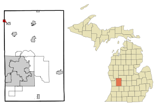
Unionville is a village in Tuscola County in the U.S. state of Michigan. The population was 508 at the 2010 census. The village is located in the northwestern corner of Columbia Township.

<span class="mw-page-title-main">Goodhue, Minnesota</span> City in Minnesota, United States

Goodhue is a city in Goodhue County, Minnesota, United States. The population was 1,176 at the 2010 census.

<span class="mw-page-title-main">Pasadena Park, Missouri</span> Village in Missouri, United States

Pasadena Park is a village in St. Louis County, Missouri, United States. The population was 470 at the 2010 census. It is part of the Normandy School District, and is distinct from the city of Pasadena Hills.

<span class="mw-page-title-main">Bellevue, Wisconsin</span> Village in Wisconsin, United States

Bellevue is a village in Brown County, Wisconsin. It was a town until incorporating as a village on February 14, 2003. The population was 14,570 at the time of the 2010 census. Bellevue is part of the Green Bay metropolitan area. Bellevue sits around 4.34 miles (6.99km) east from central Green Bay.

<span class="mw-page-title-main">Kekoskee, Wisconsin</span> Village in Wisconsin, United States

Kekoskee is a village in Dodge County, Wisconsin, United States. The population was 161 at the 2010 census.

<span class="mw-page-title-main">Neosho, Wisconsin</span> Village in Wisconsin, United States

Neosho is a village in Dodge County, Wisconsin, United States. The population was 574 at the 2010 census.

<span class="mw-page-title-main">Fairwater, Wisconsin</span> Village in Wisconsin, United States

Fairwater is a village in Fond du Lac County, Wisconsin, United States. The population was 371 at the 2010 census. The town of Metomen surrounds the village.

<span class="mw-page-title-main">Avoca, Wisconsin</span> Village in Wisconsin, United States

Avoca is a village in Iowa County, Wisconsin, United States. The population was 637 at the 2010 census. It is part of the Madison Metropolitan Statistical Area. It is named after Avoca in Ireland.

<span class="mw-page-title-main">Endeavor, Wisconsin</span> Village in Wisconsin, United States

Endeavor is a village in Marquette County, Wisconsin, United States. The population was 468 at the 2010 census.

<span class="mw-page-title-main">Ontario, Wisconsin</span> Village in Wisconsin, United States

Ontario is a village in Vernon County, Wisconsin, United States. The population was 554 at the 2010 census.

<span class="mw-page-title-main">Casnovia, Michigan</span> Village in Michigan, United States

Casnovia is a village in the U.S. state of Michigan. It is situated on the boundary between Muskegon and Kent counties and lies partially within both. The population was 319 at the 2010 census. The village is located partially within Tyrone Township.

<span class="mw-page-title-main">Cazenovia, Wisconsin</span> Village in Wisconsin, United States

Cazenovia is a village in Richland and Sauk Counties in the U.S. state of Wisconsin. The population was 318 at the 2010 census. Of this, 314 were in Richland County, and only 4 were in Sauk County.

<span class="mw-page-title-main">Wyocena, Wisconsin</span> Village in Wisconsin, United States

Wyocena is a village in Columbia County, Wisconsin, United States. The population was 768 at the 2010 census. The village is located within the Town of Wyocena. It is part of the Madison Metropolitan Statistical Area.

<span class="mw-page-title-main">Clyman, Wisconsin</span> Village in Wisconsin, United States

Clyman is a village in Dodge County, Wisconsin, United States. The population was 422 at the 2010 census. The village is located within the Town of Clyman.

<span class="mw-page-title-main">Arena, Wisconsin</span> Village in Wisconsin, United States

Arena is a village in Iowa County, Wisconsin, United States. The population was 834 at the 2010 census. The village is located within the Town of Arena. It is part of the Madison Metropolitan Statistical Area.

<span class="mw-page-title-main">Wilton, Wisconsin</span> Village in Wisconsin, United States

Wilton is a village in Monroe County, Wisconsin, United States. The population was 504 at the 2010 census. The village is located partially within the Town of Wilton and partially within the Town of Wellington.

<span class="mw-page-title-main">La Valle, Wisconsin</span> Village in Wisconsin, United States

La Valle is a village in Sauk County, Wisconsin, United States, along the Baraboo River. The population was 367 at the 2010 census. The village is located within the Town of La Valle.

References

  1. "2019 U.S. Gazetteer Files". United States Census Bureau. Retrieved August 7, 2020.
  2. 1 2 "US Board on Geographic Names". United States Geological Survey. October 25, 2007. Retrieved January 31, 2008.
  3. 1 2 "U.S. Census website". United States Census Bureau . Retrieved November 18, 2012.
  4. 1 2 "U.S. Census website". United States Census Bureau . Retrieved January 31, 2008.
  5. Stohs, Nancy J. (August 30, 1979). "Rural Nashotah likes its small-village ways". The Milwaukee Journal. p. 8. Retrieved May 26, 2015.
  6. "US Gazetteer files: 2010, 2000, and 1990". United States Census Bureau. February 12, 2011. Retrieved April 23, 2011.
  7. "US Gazetteer files 2010". United States Census Bureau. Archived from the original on July 2, 2012. Retrieved November 18, 2012.
  8. "Census of Population and Housing". Census.gov. Retrieved June 4, 2015.
  9. 1 2 "Red Circle Inn | Wedding Banquets Ceremony Receptions Milwaukee Wisconsin". Red Circle Inn.
  10. "Red Circle Inn". Archived from the original on January 6, 2010. Retrieved October 28, 2009.