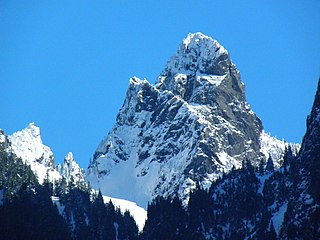
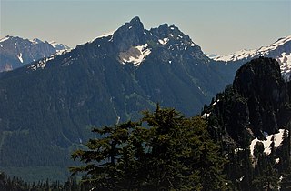
Gunn Peak is a 6,244-foot (1,903-metre) mountain summit in Snohomish County, Washington, United States.
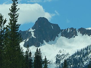
Breccia Peak is a mountain summit in the North Cascades, in Snohomish County of Washington state. Its summit is 6,487 feet (1,977 m) above sea level. The peak is the eroded remnant of a stratovolcano, and takes its name from the type of rock, breccia, that it is composed of. It is located 15 miles southeast of Darrington, Washington, and 8.7 miles (14.0 km) west of Glacier Peak, which is one of the Cascade stratovolcanoes. It is situated in the Glacier Peak Wilderness on land administered by the Mount Baker-Snoqualmie National Forest. The nearest higher peak is Mount Pugh, 3.5 miles (5.6 km) to the northwest. Precipitation runoff from Breccia Peak drains into tributaries of the Sauk River.

Whistler Mountain is a 7,790-foot (2,370-metre) mountain summit located in Chelan County of Washington state. The mountain is part of the Okanagan Range which is a sub-range of the North Cascades. Whistler Mountain is about two miles west of Washington Pass and one mile east of Rainy Pass. The North Cascades Highway bends around the southern base of the mountain between these two passes. A high ridge connects Whistler to its nearest higher neighbor, Cutthroat Peak, which is 0.78 miles (1.26 km) to the north-northeast. Precipitation runoff from the peak drains into Bridge Creek. Topographic relief is significant as the summit rises over 3,000 feet above the creek and highway in approximately one mile.

Blue Lake Peak is a 7,808-foot (2,380-metre) mountain summit in the North Cascades of Washington state. It is located in the Okanogan–Wenatchee National Forest on the shared border of Okanogan County and Chelan County. The peak is situated south of Early Winters Spires, Liberty Bell Mountain, and Washington Pass. Blue Lake is set below its west slope, and Stiletto Peak is to its south. Blue Lake Peak can be seen from the North Cascades Highway at the Blue Lake Trailhead. Precipitation runoff from Blue Lake Peak drains into tributaries of the Chelan River and Methow River. Topographic relief is significant as the summit rises 2,800 feet above Early Winters Creek in one mile (1.6 km). The mountain's toponym has not been officially adopted by the United States Board on Geographic Names. An alternate name, "Wamihaspi Peak," was published by mountaineer and author, Fred Beckey, in his guidebook.

Blackbeard Peak, also spelled Black Beard Peak, is a 7,241-foot mountain summit in the North Cascades in the U.S. state of Washington. It is located in the Okanogan–Wenatchee National Forest in Skagit County. It is situated northwest of Rainy Pass, southwest of Porcupine Peak, and southeast of Graybeard Peak. Its nearest higher neighbor is Repulse Peak, 1.06 mi (1.71 km) to the west. Blackbeard Peak can be seen from the North Cascades Highway. Precipitation runoff from Blackbeard Peak drains into Granite Creek, a tributary of the Skagit River. Topographic relief is significant as the summit rises over 3,000 feet above Granite Creek in one mile (1.6 km).

Crooked Bum is a 6,937-foot-elevation mountain summit on the crest of the North Cascades in the U.S. state of Washington. It is located in the Okanogan–Wenatchee National Forest on the shared border of Skagit County and Chelan County. It is situated immediately west of Rainy Pass and two miles east of Corteo Peak. The scenic and popular Maple Pass Trail traverses the south slope of the peak while staying above Lake Ann. Precipitation runoff from the north slope of Crooked Bum drains into Granite Creek which is a tributary of the Skagit River, whereas the south side drains into Bridge Creek which is a tributary of the Chelan River.
Molar Tooth is a 7,547-foot-elevation (2,300-meter) granite summit located on the shared border of Okanogan County and Skagit County, in Washington state. The mountain is part of the Okanagan Range which is a subset of the Cascade Range. Set in the Okanogan–Wenatchee National Forest, Molar Tooth is situated south of Cutthroat Pass, and 0.57 miles (0.92 km) north of Cutthroat Peak, which is also its nearest higher peak. The easiest climbing route is class 4 scrambling, but solid rock provides class 5 technical routes as well. Precipitation runoff from the east side of Molar Tooth drains into tributaries of the Methow River, whereas runoff from the west side drains into tributaries of the Skagit River.

Cadet Peak is a 7,186 ft mountain summit near the western edge of the North Cascades, in Snohomish County of Washington state. The peak is located southeast of Barlow Pass along the Mountain Loop Highway, and two miles east of the historic Monte Cristo area. It is situated within the Henry M. Jackson Wilderness, on land administered by the Mount Baker-Snoqualmie National Forest. The mountain was originally called Foggy Peak, for the Foggy Mine claim on the mountain's north slope, but the name was changed in 1896 to its present name, and the Foggy Peak name was transferred to the peak immediately northwest of Cadet. Back in the old mining days, the long sub-range stretching from Cadet Peak to Sheep Mountain was known as Pride of the Mountains Range. Cadet's nearest higher neighbor is Kyes Peak, 1.59 mi (2.56 km) to the south-southeast. Precipitation runoff from the mountain drains into tributaries of the Sauk River.

Johnson Mountain is a 6,721-foot (2,049-metre) mountain summit located in the Glacier Peak Wilderness of the North Cascades in Washington state. The mountain is situated in eastern Snohomish County, in the Mt. Baker-Snoqualmie National Forest. Its nearest higher peak is White Mountain, 3.3 mi (5.3 km) to the northeast, along with Indian Head Peak 3.38 mi (5.44 km) to the east. Precipitation runoff from the mountain drains into tributaries of the Sauk River. The mountain's name honors Mackinaw Johnson, a prospector who had a cabin in the vicinity.

Glory Mountain is a 7,228-foot (2,203-metre) mountain summit located in the North Cascades Range in Chelan County of Washington state. Glory Mountain is situated southeast of Trapper Lake on the shared border of North Cascades National Park and Glacier Peak Wilderness. The nearest higher peak is Trapper Mountain, 1.72 miles (2.77 km) to the west. Precipitation runoff from the mountain drains into Cottonwood Creek and Flat Creek, both tributaries of the Stehekin River. An unofficially named secondary peak called Halleluja Peak 7,120+ ft lies 0.32 miles (0.51 km) to the west of the summit.
Mount Forgotten is a 6,005-foot-elevation (1,830-meter) mountain summit near the western edge of the North Cascades, in Snohomish County of Washington state. It is located five miles north of Barlow Pass along the Mountain Loop Highway near the Monte Cristo area and is situated on land administered by the Mount Baker-Snoqualmie National Forest. The nearest higher peak is Mount Pugh, 4.22 mi (6.79 km) to the northeast. Precipitation runoff from the mountain drains into tributaries of the Sauk River.

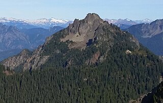
Gothic Peak is a 6,213-foot (1,894-metre) multi-peak mountain summit located near the western edge of the North Cascades Range, in Snohomish County of Washington state. It is located south of Barlow Pass along the Mountain Loop Highway near the Monte Cristo area. It is situated on land administered by the Mount Baker-Snoqualmie National Forest. The mountain was named for early prospector William Gothic, who was one of the first to stake a claim in Gothic Basin. The mountain's name was officially adopted in 1967. The nearest higher peak is Del Campo Peak, 0.5 miles (0.80 km) to the northeast, and Foggy Pass is the low point between the two peaks. Foggy Lake lies in Gothic Basin below the east face of Gothic Peak and collects precipitation runoff which ultimately drains to South Fork Sauk River via Weden Creek. Runoff from the west side of the mountain drains into the Sultan River. The first ascent of the mountain was made on June 10, 1934, by Don Blair, Willard Carr, Norval Grigg, and Art Winder. In terms of catching favorable weather, the best months for climbing are July through September.
Indecision Peak is a 7,945 ft (2,420 m) double-summit mountain located in the North Cascades in the U.S. state of Washington. It situated in North Cascades National Park, on the crest of the Cascade Range, on the shared border of Chelan County with Skagit County. Despite its position only 5 mi (8.0 km) west of the North Cascades Highway, it is not visible from any road. Its nearest higher neighbor is Mount Arriva, 0.92 mi (1.48 km) to the north. The first ascent of the summit was made August 2, 1972, by Bill Arundell, Frank King, Marilyn and Stan Jensen, and Joanne Williams. The lower northeast summit is known as Meulefire Peak (~7,930 ft), which is a portmanteau of Meulemans and Firey, the names of the first mountaineers to climb it in 1966.

Morning Star Peak is a 6,020 ft (1,830 m) mountain summit located near the western edge of the North Cascades, in Snohomish County of Washington state. It is situated 2.5 mi (4.0 km) southwest of Barlow Pass along the Mountain Loop Highway near the Monte Cristo area. It is set on land managed by Mount Baker-Snoqualmie National Forest. The nearest higher neighbor is Sperry Peak, 1 mile (1.6 km) to the northwest. Precipitation runoff from the south side of the mountain drains into the Sultan River, and the north side drains into headwaters of the Stillaguamish River. July through September offer the most favorable weather for climbing this mountain.

Little Big Chief Mountain is a 7,225-foot (2,202-metre) mountain summit located immediately southwest of Dutch Miller Gap, on the common border separating King County and Kittitas County in Washington state. It is situated within the Alpine Lakes Wilderness, on land managed by Mount Baker-Snoqualmie National Forest. Little Big Chief Mountain is set ten miles northeast of Snoqualmie Pass on the crest of the Cascade Range. Precipitation runoff from the west side of the mountain drains into tributaries of the Snoqualmie River, whereas the east side drains into tributaries of the Yakima River. The nearest higher peak is Summit Chief Mountain, 0.7 miles (1.1 km) to the southwest, and Chimney Rock is set 2.2 miles (3.5 km) to the southwest. The first ascent of this peak was made in August 1939 by Fred Beckey, Wayne Swift, Joe Barto, and Campbell Brooks. This mountain was named for Lorenz A. Nelson during the 1925 Mountaineers climb of Summit Chief Mountain. Nelson was a pioneering mountaineer who led first ascents of Mount Olympus, Mount Meany, and Chiwawa Mountain.

Jove Peak is a 6,007 ft (1,830 m) mountain summit located 5 mi (8.0 km) north of Stevens Pass on the common border of Snohomish County with Chelan County in Washington state. This peak is situated 12 mi (19 km) west of Lake Wenatchee, in the Henry M. Jackson Wilderness, on land managed by Mount Baker-Snoqualmie National Forest and Okanogan-Wenatchee National Forest. Jove Peak was named by Albert Hale Sylvester for Jove in association with the mythology-theme of nearby Minotaur and Theseus Lakes which are near Labyrinth Mountain, 2.5 mi (4.0 km) to the northeast. Precipitation runoff from the peak drains west into headwaters of Rapid River, or east into Rainy Creek which is a tributary of the Little Wenatchee River.

Silvertip Peak is a 6,140-foot (1,870-metre) mountain summit located in the North Cascades, in Snohomish County of Washington state. It is situated 3.5 miles south of Barlow Pass along the Mountain Loop Highway, in the Henry M. Jackson Wilderness, on land managed by Mount Baker-Snoqualmie National Forest. Precipitation runoff from the mountain drains north into tributaries of the Sauk River, or south into headwaters of Silver Creek which is a tributary of Skykomish River. Neighbors surrounding Silvertip include Gothic Peak, Del Campo Peak, Sheep Mountain, Cadet Peak, and Columbia Peak. Silver Lake and Poodle Dog Pass lie on the east flank of Silvertip, the Monte Cristo mining ghost town sits at the northeast base, and the Mineral City ghost town is at the southern foot of this peak. This peak was named in association with the nearby Silver Tip mining claim.

Painted Mountain is a 6,975-foot-elevation (2,126-meter) summit located in the North Cascades, in Snohomish County of Washington state. The mountain is situated in the Glacier Peak Wilderness on land managed by Mount Baker-Snoqualmie National Forest. Neighbors include line parent Black Mountain, 2.2 mi (3.5 km) to the east, and Glacier Peak is 7 mi (11 km) to the northeast. Precipitation runoff from the peak drains west into tributaries of the North Fork Sauk River. Topographic relief is significant as the summit rises nearly 5,000 feet above the river in less than two miles.
Bedal Peak is a 6,554-foot-elevation (1,998-meter) mountain summit located in the North Cascades, in Snohomish County of Washington state. The mountain is situated in the Henry M. Jackson Wilderness, on land managed by Mount Baker-Snoqualmie National Forest. The nearest higher neighbor is line parent Sloan Peak, 2 mi (3.2 km) to the south-southeast. Precipitation runoff from the peak drains west to the South Fork Sauk River via Bedal Creek, as well as north and east into tributaries of the North Fork. The north and south forks merge at the northwest base of the mountain to form the Sauk River. Topographic relief is significant as the summit rises 5,250 feet above the Sauk River Valley and Mountain Loop Highway in approximately two miles.

Foggy Peak is a 6,810-foot-elevation (2,076-meter) mountain summit in Snohomish County of Washington state.


