Devil's Path (hiking trail)

Last updated
Devil's Path
Devilspathchimney.jpg
A backpacker negotiates a rock chimney on Indian Head Mountain
Length24.2 mi (38.9 km)
Location Town of Hunter / Town of Lexington, Greene County, New York, USA
Trailheads Prediger Road (east); Spruceton Road (west)
UseHiking
Elevation gain/loss9,000 feet (2,700 m) gain approximately
Highest point West Kill Mountain, 3,880 ft (1,180 m)
Lowest point Stony Clove Notch, 2,220 ft (680 m)
DifficultyStrenuous
Seasonall
SightsNorthern Catskill Mountains
Hazards Steep, precarious climbs

The Devil's Path is a hiking trail in the Greene County section of the Catskill Mountains of New York, sometimes described as one of the more challenging trails in the New York Tri-state area. [1] It goes across the eponymous mountain range and then three other peaks to the west, offering hikers and peakbaggers a chance to reach the summits of five of the 35 Catskill High Peaks (two more are reachable by detours). It draws hikers from not just the region but far outside, due to the challenging climbs straight up and down the steep gaps between the four peaks of the range, which often require hikers to use hands as well as feet to pull themselves almost straight up cliffs and through rocky chutes. These climbs, however, lead to views across the Catskill range.

Contents

Most hikers use the trail for day trips to one or two summits along the range, via the trails that go up into the cols. But backpackers have done weekend trips due to the easy availability of a state-owned campground at Devil's Tombstone, near the single road crossing at Stony Clove Notch. It is also possible for determined hikers to complete the entire trail in a single, long day.

The portion of the trail from Plateau Mountain to just east of Indian Head Mountain is currently part of the Long Path. Most of it is on state-owned Forest Preserve land in New York's Catskill Park. Most of it lies within two New York State Department of Environmental Conservation management units, the Indian Head Wilderness Area east of Stony Clove Notch and (currently) the Hunter Mountain Wild Forest from there to Diamond Notch, then the West Kill Wilderness Area.

History

While some of the peaks east of Stony Clove Notch had been climbed for quite some time, according to Catskill forest historian Michael Kudish, the modern Devil's Path was first cut from the Old Overlook Road to Mink Hollow in 1929, shortly after the state acquired the property. Plateau followed in 1934 after that purchase was made, and the following year the route up Hunter from the notch was opened.

However, for several decades afterward there was no new construction. In 1973, the state finally opened the route down to the falls, and the final section over West Kill came shortly thereafter. [2] Despite an original idea to continue the trail on over North Dome Mountain and Mount Sherrill to the west that led to a sign (still in existence) erected at the proposed junction site, those two peaks remain trailless today. There have been some proposals within NYSDEC of building a modified extension but it does not appear likely to happen at this point.

Description

The Devil's Path has a single road crossing, NY 214 at Stony Clove Notch. This is often used to divide the eastern half of the trail, the one that gives it its reputation, from the more remote but less challenging western half. It is blazed with NYSDEC red plastic discs throughout.

When hiked in this direction, the mountain summits get higher as the gaps between them get lower.

Eastern section

This is the "classic" Devil's Path. It features four major summits, with the trail going straight up and down the fall line into the gaps between, with all the rugged terrain that implies.

Schoharie headwaters

Officially, the blazing starts at the junction of Prediger Road near Elka Park in the Town of Hunter. The eastern trailhead is located at the end of Prediger. It is often reached via the steep drive up nearby Platte Clove Road except during winter, when the road is closed.

Just after its start, the trail crosses an unnamed tributary of Schoharie Creek and then turns south, crossing the state-land boundary after a short distance. At 0.45 mile (725 m) from the start, the blue-blazed Jimmy Dolan Notch Trail leaves and crosses over the Schoharie. It offers a shorter route to the eponymous feature for those planning to skip Indian Head Mountain, the first peak on the trail's itinerary.

The Devil's Path itself remains level, trending eastward for the next 1.4 miles (2.3 km) past the source of the Schoharie to a junction with the Old Overlook Road which once connected Platte Clove Road and Overlook Mountain to the south. Today the portion joining the trail is part of the Long Path, leading down through the Catskill Center for Conservation and Development's Platte Clove Preserve. Shortly after this junction, the Devil's Path leaves the road and begins to climb Indian Head.

Indian Head

Indian Head and Twin Mountains on the Eastern Devil's Path, October 2012 Indian Head and Twin Mountains on the Eastern Devil's Path, October 2012.jpg
Indian Head and Twin Mountains on the Eastern Devil's Path, October 2012

The ascent is steep for the next 1.25 miles (2.01 km), finally reaching a lookout to the north on the mountain's east slope. Kaaterskill High Peak predominates from here. The trail then runs around through an increasingly boreal forest to the mountain's north slope, where a view cut (somewhat controversially) by DEC in the past offers a preview of later, more expansive vistas to the south. After a half-mile (1 km), the trail reaches a section where roots form a sort of ladder up a steep rock face. Just past it is a ledge with a wide view over the Hudson River and points east.

It is another half-mile from here to the summit, across mostly level stretches of trail save another steep cliff at 3,500 feet (1,067 m) in elevation (where special DEC regulations banning fires and camping except during winter take effect). An overhanging tree formerly provided the only way to get up a narrow cleft in the rock here until July 2013 when it collapsed. Hikers must now edge their way underneath the trunk to get to the cleft and use handholds to climb up without a pack through the narrow opening. The mountain's 3,573-foot (1,089 m) summit is unremarkable after all this, with a sudden drop the only indicator it has been reached.

The actual summit is just off the trail, with a limited view available to the west. From here it drops down another half-mile into 3,200-foot (975 m) Jimmy Dolan Notch, the highest col on the trail, passing a few switchbacks and chutes along the way. The trail of the same name returns here.

A portion of the view from Twin's southern summit. Central Catskills from Twin south summit.jpg
A portion of the view from Twin's southern summit.

Twin

The trail starts climbing again almost right out of the notch, alternating between challenging ledge scrambles (although not as serious as the ones on Indian Head) and level sections over the next 0.4 mile (640 m). These take over shortly after the 3,500-foot (1,100 m) contour is crossed again, and the mountain's southern summit offers a sweeping panorama of the Catskills that has been considered by many to be one of the best views in the region. Slide Mountain and all the major peaks around it are visible across the flat valley of Esopus Creek and Ashokan Reservoir in central Ulster County. Close up loom Twin's true northern summit and Sugarloaf Mountain.

Another half-mile and a gentle descent into the col followed by a slightly steeper ascent separates the south summit from Twin's true, 3,640-foot (1,109 m) summit. The view just past it is not quite so sweeping, but also takes in Hunter Mountain, the Catskill's second highest peak, to the west.

Narrow passage through rock cleft on Twin Devil's Path cleft on Twin.jpg
Narrow passage through rock cleft on Twin

.

The trail then descends 0.75-mile (1.21 km) down through switchbacks, rock chutes and some more scrambles to Pecoy Notch, about 2,900 feet (884 m) above sea level. There are some views available to the north in the lower reaches. At the notch, another trail runs north about 2 miles (3.2 km) to the nearby community of Elka Park.

Sugarloaf

After a short level stretch, the climbing resumes. The eastern slope of Sugarloaf is similar to its counterpart at Twin, except it offers more chutes to surpass and climb, plus some sections where the trail passes narrowly between large rock outcrops. There are some good views back toward Twin where damage caused by past landslides is apparent.

The trail becomes more and more level after the 3,500-foot (1,100 m) marker is reached. But the 3,800-foot (1,158 m) summit is still some distance off, 1.2 miles (1.9 km) from Pecoy Notch, and the elevation gain to reach it comes in extremely small steps up. Only when the trail starts to slope down and side trails lead off to views similar to those available from Twin is it apparent the climb has been successful.

In the next mile (1.6 km), the trail descends 1,600 vertical feet (488 m) to Mink Hollow. The rock chutes here are some of the most challenging on the entire Devil's Path, and they have led to the nickname "Suicide Mountain" by those using it as a route up in winter.

Shortly before Mink Hollow, a new routing of the trail of the same name comes in from the north, another route off the range if needed or desired. At the col, the Mink Hollow Trail follows an old road south to a lean-to and trailhead near Lake Hill.

Plateau

It is yet another steep and rocky climb up the eastern slope of Plateau Mountain. A good spring can be found about a quarter-mile from the hollow (headed up the mountain), and the 3,855-foot (1,175 m) summit itself is just off-trail 0.75-mile (1.21 km) later. The newly rerouted Long Path also comes in from the South on Plateau.

Trail across Plateau, in winter. Snowshoe track in woods.jpg
Trail across Plateau, in winter.

The ensuing walk across the aptly named Plateau is seen as another attraction of the trail. While there are no views, the 2.25 miles (3.62 km) are the longest high-elevation level walk in the Catskills, surrounded entirely by boreal forest, with only 200 feet (62 m) of elevation loss (or gain) along the way. It comes to an end shortly after Danny's Lookout to the northeast, at Orchard (sometimes Orchid) Point. Here Hunter, Southwest Hunter Mountain and West Kill Mountain loom ahead, across the depth of Stony Clove Notch.

Again the trail descends steeply and drastically, 1,400 feet (427 m) into the notch. Here, the trail crosses Route 214 and there is a parking lot and picnic area overlooking a small green lake. There is a water spout in the picnic area, but it seems water does not always flow from it. In season, the state charges a fee for use of the parking lot at the trail crossing. The neighboring campground is a short walk south along Route 214.

Western section

This section is less popular for day hikes[ citation needed ] since it does not offer easy access from cols, and less of the rocky, steep terrain found to the east.[ original research? ] It only goes over the summit of one mountain, and avoids that of Hunter. However, there are still a few attractions.

Stony Clove Notch Stony Clove Notch 2011.jpg
Stony Clove Notch

Hunter

After crossing just below the outlet of Notch Pond, the trail shortly begins to climb and switchback, passing a massive pair of stone outcrops known as the Devil's Portal. Above, the trail follows an old wood road into an area where a few hemlocks remain from tannin-seeking loggers in the late 19th century. Some spruce may be found along here, too.

Leaving the old road shortly before it dead-ends, the trail goes through a slightly more level area where hungry hikers can snack on wild blackberries and raspberries in season, then levels out just below 3,500 feet (1,100 m), in an area where paper birch, red spruce and fern make up the forest ... a sign of the heavy logging of this area a century ago by the West Virginia-based Fenwick Lumber Company.

At 2.15 miles (3.46 km), from the notch, it reaches Devil's Acre, the low point between Hunter and trailless Southwest Hunter. It begins with the junction with the yellow-blazed Hunter Mountain Trail, which leads uphill (approximately 300 feet (91 m) elevation, 1.6 miles) to Hunter's summit and its fire tower. Shortly after the junction is the Devil's Acre Lean-To. Past the lean-to is a fairly wet area, a result of all the past logging, then the trail begins to descend. A small cairn on the left side of the trail marks the beginning of the old narrow-gauge railbed used by most hikers to reach the elusive summit of Southwest Hunter.

After going through another level area a half-mile long with impressive rock outcrops to one side, the Devil's Path reaches another superb viewpoint over the cirque that gives rise to the West Kill. Southwest Hunter's ridgeline can be previewed by those heading in that direction, and across Diamond Notch rises West Kill itself. Remnants of camping can sometimes be found here although it is not permitted.

Bridge over Diamond Notch Falls Diamond Notch Falls, Spruceton, NY.jpg
Bridge over Diamond Notch Falls

The trail then begins a long, leisurely but steady 1.5-mile (2.4 km) descent down the south side of Hunter Mountain to the junction with the blue-blazed Diamond Notch Trail at a bridge over a waterfall on the West Kill known variously as West Kill Falls or Diamond Notch Falls. The latter trail can be followed 0.7-mile (1.1 km) to the parking lot at the end of Spruceton Road (Greene County Route 7).

West Kill

The newest (it was cut in 1969) and least-hiked portion of the Devil's Path begins just past the West Kill. The trail branches off to follow the water for a few hundred feet, then slowly begins traversing up the huge mountain, the sixth-highest in the Catskills. A good spring is found to the side of the trail 0.7-mile (1.1 km) from the ford. Afterwards, it levels off for a while, then begins attacking the mountain more directly, requiring once again the use of hands through some steep chutes. The woods aside the trail become more and more boreal, and at about 3,400 feet (1,036 m), it levels off again. Another 0.7-mile (1.1 km) from the spring, there is a large rock overhang, an excellent place to camp just below the 3,500-foot (1,100 m) marker, where camping is prohibited for most of the year.

The Blackhead Range and ski trails at Hunter Mountain from Buck Ridge in autumn Blackhead Range from Buck Ridge Lookout in autumn.jpg
The Blackhead Range and ski trails at Hunter Mountain from Buck Ridge in autumn

The trail remains level through the boreal woods, then begins to climb seriously to Buck Ridge Lookout, another 0.7-mile (1.1 km) from the cave. This sweeping view takes in primarily Hunter and Southwest Hunter, but also offers a good view down Ox Clove towards the Lanesville area and the lesser peaks behind it. Southern peaks such as Slide and Peekamoose are also visible. A short path through the woods leads to another, smaller overlook north taking in Rusk Mountain.

A short distance (0.1 mile, 60 m) past the lookout is the 3,880-foot (1,183 m) summit of West Kill itself, the only summit in the Catskills marked by an official sign to that effect. There is no view. The trail begins to descend shortly afterwards, past an unreliable spring.

The remainder of the Devil's Path receives less foot traffic than the other sections and is as a result sometimes inadequately maintained. Dropping off the summit cone relatively quickly, it then descends very gently to about 3,300 feet (1,005 m) over the next two miles (3.2 km) and then, after a small creek that can supply water in all but the driest times, abruptly begins to climb up a rocky chute, then some minor ledges, to the 3,420-foot (1,042 m) summit known as either West West Kill or St. Anne's Peak. It goes right over it, but there are no real views except when the leaves are down.

From there the trail goes down along a series of long, switched-back traverses 2.35 miles (3.78 km) to its second Mink Hollow, a swampy area between West West Kill and North Dome Mountain. A DEC sign there gives mileage in both directions despite the lack of a junction — a legacy of a plan to later extend the Devil's Path over North Dome and Mount Sherrill. After this, the trail travels due north past the outlet stream from the swampy col through a state-land corridor of tall, old-growth trees, lush fern beds and fields of glacial erratics to some old-growth hemlocks and, finally, its western end at Spruceton Road 1.4 miles (2.3 km) later.

Common day trips

Many common hiking routes, particularly those made by aspiring members of the Catskill Mountain 3500 Club, use part of the Devil's Path and its connecting peaks. Many combinations are possible.

Related Research Articles

<span class="mw-page-title-main">Hunter Mountain (New York)</span> Highest mountain in Greene County, New York, and second highest in the Catskills

Hunter Mountain is in the towns of Hunter and Lexington, just south of the village of Hunter, in Greene County, New York, United States. At approximately 4,040 feet (1,231 m) in elevation, it is the highest peak in the county and the second-highest peak in the Catskill Mountains.

<span class="mw-page-title-main">Long Path</span> Hiking trail from George Washington Bridge to Mohawk River valley in upstate New York

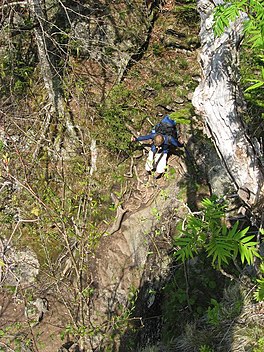
The Long Path is a 357-mile (575 km) long-distance hiking trail beginning in New York City, at the West 175th Street subway station near the George Washington Bridge and ending at Altamont, New York, in the Albany area. While not yet a continuous trail, relying on road walks in some areas, it nevertheless takes in many of the popular hiking attractions west of the Hudson River, such as the New Jersey Palisades, Harriman State Park, the Shawangunk Ridge and the Catskill Mountains. It offers hikers a diversity of environments to pass through, from suburbia and sea-level salt marshes along the Hudson to wilderness and boreal forest on Catskill summits 4,000 feet (1,220 m) in elevation.

<span class="mw-page-title-main">Slide Mountain (Ulster County, New York)</span> Highest peak of New Yorks Catskill Mountains

Slide Mountain is the highest peak in the Catskill Mountains of the U.S. state of New York. It is located in the town of Shandaken in Ulster County. While the 4,180-foot (1,270 m) contour line on topographic maps is generally accepted as its height, the exact elevation of the summit has never been officially determined by the U.S. Coast and Geodetic Survey, and many informal surveys suggest the mountain may actually top 4,200 feet (1,300 m) above sea level.

<span class="mw-page-title-main">Stony Clove Notch</span> Mountain pass in Greene County, New York

Stony Clove Notch is a narrow pass, roughly 2,220 feet in elevation located in the Town of Hunter in Greene County, New York, deep in the Catskill Mountains. It is traversed by New York State Route 214, although in the past the Ulster and Delaware Railroad went through it as well.

<span class="mw-page-title-main">Platte Clove</span> Valley in New York State, USA

Platte Clove, sometimes Plattekill Clove, is a narrow and steep valley in the Catskill Mountains of New York.

<span class="mw-page-title-main">Kaaterskill High Peak</span> Mountain in United States of America

Kaaterskill High Peak is one of the Catskill Mountains, located in the Town of Hunter in Greene County, New York, United States. It was once believed to be the highest peak in the entire range, but its summit, at 3,655 feet (1,114 m) in elevation, places it only 23rd among the Catskill High Peaks. It is, however, the fourth most prominent peak in the range. Due to its situation as the easternmost High Peak, its summit is just outside the watersheds of New York City's reservoirs in the region.

<span class="mw-page-title-main">New York State Route 23A</span> State highway in Greene County, New York, US

New York State Route 23A (NY 23A) is an east–west state highway in Greene County, New York, in the United States. It serves as a 34.56-mile (55.62 km) alternate route of NY 23 through the northern Catskill Mountains. The route passes several of the Catskill High Peaks, including Hunter Mountain, before dropping into the Hudson Valley via Kaaterskill Clove and ending at an intersection with U.S. Route 9W (US 9W) in the village of Catskill. NY 23A was assigned in the mid-1920s and has not been changed since. A portion of the route through Kaaterskill Clove was closed for several months in 2006 after landslides triggered by heavy rains damaged the route.

<span class="mw-page-title-main">Rusk Mountain</span> Mountain in New York, United States

Rusk Mountain is a peak located in the towns of Jewett and Lexington in Greene County, New York, United States. At 3,680 feet (1,120 m) in elevation, it is the 20th-highest peak in the Catskill Mountains and considered a member of the Catskill High Peaks. While there is no maintained trail, a bushwhack to the summit is considered relatively easy, and required for membership in the Catskill Mountain 3500 Club.

<span class="mw-page-title-main">Panther Mountain (New York)</span> Mountain in New Yorks Catskill range that rose from old meteor crater

Panther Mountain is one of the Catskill High Peaks, located in the Town of Shandaken in Ulster County, New York. At approximately 3,720 feet (1,130 m) in elevation, it is the 18th highest in the range. A combination of factors has led some geologists to believe the mountain is on the site of an ancient meteorite impact crater.

<span class="mw-page-title-main">Hunter Mountain Fire Tower</span> Historic fire lookout tower in New York, United States

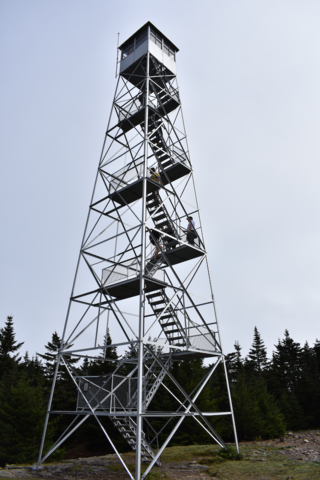
The Hunter Mountain Fire Tower is located on the summit of the eponymous mountain, second highest of the Catskill Mountains in the U.S. state of New York. It was the first of 23 fire lookout towers built by the state in the region, and the next-to-last of the five still standing to be abandoned.

<span class="mw-page-title-main">Southwest Hunter Mountain</span> Mountain in United States of America

Southwest Hunter Mountain (Leavitt Peak) is a subpeak of Hunter Mountain, located in Greene County, New York. It is considered one of the Catskills' High Peaks in its own right, because of its separation from the main summit, and its topographic prominence. Hunter Mountain is named after John Hunter, who also gave his name to the town of Hunter.

West Kill Mountain, or Westkill Mountain, is located in Greene County, New York. The mountain is named after the West Kill stream which flows along its northern side, and is part of the Devil's Path range of the Catskill Mountains. To the east, West Kill Mountain faces Southwest Hunter Mountain across 800-foot-deep (240 m) Diamond Notch; to the west, West Kill faces North Dome across Mink Hollow.

<span class="mw-page-title-main">Twin Mountain (Greene County, New York)</span> Mountain in New York, United States of America

Twin Mountain is a mountain located in Greene County, New York. Twin gets its name from its two summits; the lower, 3,590-ft (1,090 m) peak is about .5 miles (0.8 km) to the southeast of the higher. The mountain is part of the Devil's Path range of the Catskill Mountains. To the northwest, Twin Mtn. is separated from Sugarloaf Mountain by Pecoy Notch; to the southeast, Twin Mtn. is separated from Indian Head Mountain by Jimmy Dolan Notch.

<span class="mw-page-title-main">Sugarloaf Mountain (Greene County, New York)</span> Mountain located in Greene County, New York

Sugarloaf Mountain is a mountain located in Greene County, New York. The mountain is part of the Devil's Path range of the Catskill Mountains. To the northwest, Sugarloaf is separated from Plateau Mountain by Mink Hollow Notch; to the southeast, Sugarloaf is separated from Twin Mountain by Pecoy Notch.

<span class="mw-page-title-main">Plateau Mountain (New York)</span> High Peak of New Yorks Catskill Mountains with two-mile (3.2 km) summit ridge

Plateau Mountain is located in the town of Hunter in Greene County, New York, United States. It is part of the Devil's Path range of the Catskill Mountains. Plateau has a two-mile-long (3.2 km) summit ridge above 3,500 feet (1,100 m). The highest point, at least 3,840 feet (1,170 m), is at the southeast end, facing Sugarloaf Mountain to the east across Mink Hollow Notch. It is the 12th-highest peak in the range Devils Tombstone is located west of Plateau Mountain. The northwest end faces Hunter Mountain to the west across 1,400-foot deep (430 m) Stony Clove Notch.

<span class="mw-page-title-main">Balsam Mountain (Ulster County, New York)</span> 28th highest peak of Catskill Mountains

Balsam Mountain is one of the High Peaks of the Catskill Mountains in the U.S. state of New York. Its exact height has not been determined, so the highest contour line, 3,600 feet (1,100 m), is usually given as its elevation. It is located in western Ulster County, on the divide between the Hudson and Delaware watersheds. The summit and western slopes of the peak are within the Town of Hardenburgh and its eastern slopes are in Shandaken. The small community of Oliverea is near its base on that side. Most of the mountain is publicly owned, managed by the New York State Department of Environmental Conservation as part of the state Forest Preserve, part of the Big Indian-Beaverkill Range Wilderness Area in the Catskill Park. The summit is on a small corner of private land.

<span class="mw-page-title-main">Balsam Lake Mountain</span> Westernmost of the Catskill High Peaks in U.S. state of New York

Balsam Lake Mountain is one of the Catskill Mountains, located in the Town of Hardenburgh, New York, United States. It is the westernmost of the range's 35 High Peaks. Its exact height has not been determined, but the highest contour line on topographic maps, 3,720 feet (1,130 m), is usually given as its elevation.

<span class="mw-page-title-main">Graham Mountain (New York)</span> Highest privately owned summit in New Yorks Catskill Mountains

Graham Mountain is the seventh highest of the Catskill High Peaks and the highest privately owned mountain in the range. It is located in the town of Hardenburgh, New York, United States.

<span class="mw-page-title-main">Catskill Escarpment</span>

The Catskill Escarpment, often referred to locally as just the Escarpment or the Great Wall of Manitou, and known as the Catskill Front to geologists, is the range forming the northeastern corner of the Catskill Mountains in Greene and Ulster counties in the U.S. state of New York. It rises very abruptly from the Hudson Valley to summits above 3,000 feet (910 m) in elevation, including three of the Catskill High Peaks, with almost no foothills. The plateau to the south and west averages 2,000 feet (610 m) above sea level.

<span class="mw-page-title-main">Deep Notch</span>

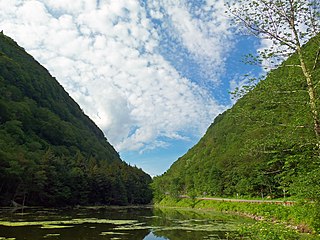
Deep Notch, sometimes West Kill Notch, or Echo Notch, is a mountain pass in Lexington, New York, United States. It divides two Catskill peaks, both subpeaks of high peaks of the range. The narrow groove between the steep, high slopes on either side is traversed by state highway NY 42 and the Shandaken Tunnel, part of the New York City water supply system. It has been called "striking" and "a marvel of grandeur and beauty".

References

  1. Regenold, Stephen (September 25, 2009). "2 Days, 3 Nights, on a Path Named for a Devil". The New York Times . Retrieved September 25, 2009.
  2. Kudish, Michael, The Catskill Forest: A History, Purple Mountain Press, Fleischmanns, New York, ISBN   1-930098-02-2, 2000, 121

Further reading