
The San Francisco Peninsula is a peninsula in the San Francisco Bay Area that separates San Francisco Bay from the Pacific Ocean. On its northern tip is the City and County of San Francisco. Its southern base is Mountain View, in Santa Clara County, south of Palo Alto and north of Sunnyvale and Los Altos. Most of the Peninsula is occupied by San Mateo County, between San Francisco and Santa Clara counties, and including the cities and towns of Atherton, Belmont, Brisbane, Burlingame, Colma, Daly City, East Palo Alto, El Granada, Foster City, Hillsborough, Half Moon Bay, La Honda, Loma Mar, Los Altos, Menlo Park, Millbrae, Pacifica, Palo Alto, Pescadero, Portola Valley, Redwood City, San Bruno, San Carlos, San Mateo, South San Francisco, and Woodside.

State Route 1 (SR 1) is a major north–south state highway that runs along most of the Pacific coastline of the U.S. state of California. At 656 miles (1,056 km), it is the longest state route in California, and the second-longest in the US after Montana Highway 200. SR 1 has several portions designated as either Pacific Coast Highway (PCH), Cabrillo Highway, Shoreline Highway, or Coast Highway. Its southern terminus is at Interstate 5 (I-5) near Dana Point in Orange County and its northern terminus is at U.S. Route 101 (US 101) near Leggett in Mendocino County. SR 1 also at times runs concurrently with US 101, most notably through a 54-mile (87 km) stretch in Ventura and Santa Barbara counties, and across the Golden Gate Bridge.

San Mateo County, officially the County of San Mateo, is a county located in the U.S. state of California. As of the 2020 census, the population was 764,442. Redwood City is the county seat, and the third most populated city following Daly City and San Mateo. San Mateo County is included in the San Francisco–Oakland–Berkeley, CA MSA, Silicon Valley, and is part of the San Francisco Bay Area, the nine counties bordering San Francisco Bay. It covers most of the San Francisco Peninsula. San Francisco International Airport is located in the northeastern area of the county and is approximately 7 miles (11 km) south of the city and county limits of San Francisco, even though the airport itself is assigned a San Francisco postal address. The county's built-up areas are mostly suburban, and are home to many corporate campuses.

Montara is a census-designated place (CDP) in San Mateo County, California, United States. The population was 2,833 at the 2020 census. Nearby communities include Moss Beach and Princeton-by-the-Sea.
Pacifica is a city in San Mateo County, California, on the coast of the Pacific Ocean between San Francisco and Half Moon Bay.
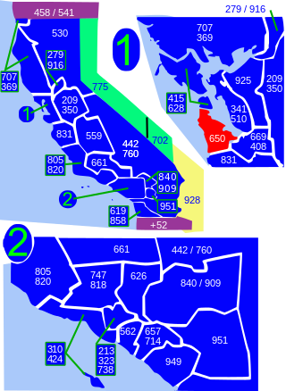
Area code 650 is a telephone area code in the North American Numbering Plan (NANP) for the San Francisco Bay Area in the U.S. state of California. It was split from area code 415 on August 2, 1997, and includes most of San Mateo County, part of San Francisco, and the northwestern portion of Santa Clara County including Palo Alto, Mountain View, and Los Altos.

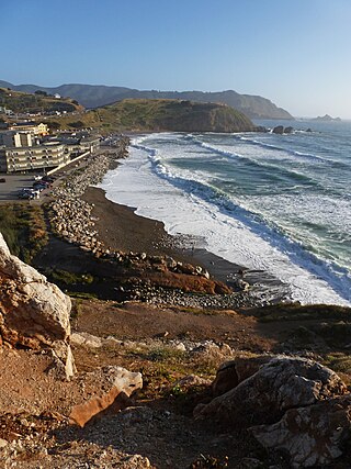
Devil's Slide is a coastal promontory in California, United States. It lies on the San Mateo County coast between Pacifica and Montara. Its name comes from the rocky edges prone to accident.

Milagra Ridge is a 275-acre (111 ha) open space park that is an isolated island ecosystem, located about 7 miles (11 km) south of San Francisco, between the cities of Pacifica and Daly City. It was first inhabited by the Ohlone indigenous people, and was later claimed by Spanish settlers and Mexican ranchers.
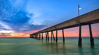
Rockaway Beach is a shoreline area of the Pacific Ocean in the southern portion of Pacifica, California, United States, approximately 7 miles (11 km) south of the city of San Francisco. It is located within a gently curving embayment with direct access via Rockaway Beach Avenue and providing easy access to Highway 1.

Mussel Rock is a rock formation on the coast of San Mateo County, California, offshore from Daly City. It consists of one large and numerous smaller rocks of a type known as a stack, where a headland is eroded unevenly, leaving small islands. The rock itself is located 15 meters from the shore of Mussel Rock Park and stands 18 meters tall.
Martini Creek is a coastal stream whose watershed lies entirely within San Mateo County, California, United States on the western exposures of the Montara mountain block, discharging to the Pacific Ocean. It flows about 2 miles (3 km) from its source on Montara Mountain to its mouth in Montara State Beach. This stream has a drainage basin composed of open space and agricultural lands. Some of the basin has moderate to steep slopes and much of the basin habitat is northern coastal scrub, and in places almost of a pygmy forest nature.

Montara State Beach is a beach located in the coastal region of the U.S. state of California, eight miles north of Half Moon Bay on State Route 1. It is operated by the California State Department of Parks and Recreation under the San Mateo Coast Sector Office. It is one of the cleanest beaches in the state and is known for surfing and fishing.

The Ocean Shore Railroad was a railroad built between San Francisco and Tunitas Glen, and Swanton and Santa Cruz that operated along the Pacific coastline from 1905 until 1921. The route was originally conceived to be a continuous line between San Francisco and Santa Cruz, but the 1906 San Francisco Earthquake, financial difficulties, and the advent of the automobile caused the line to never reach its goals, and remain with a Northern and Southern division.

Pedro Mountain Road describes a series of historical road crossings of Pedro Mountain, a promontory ridge located between Montara Mountain and the coastal cliffs of Devil's Slide in San Mateo County, California. This Pedro Mountain headland blocks the easy passage of coastal travelers between the Pedro Valley in Pacifica, California and Montara, California. The most prominent of these Pedro Mountain roads was Coastside Boulevard, the 1914 to 1937 coastal highway 57, which remains in use today as part of the trail network of McNee Ranch State Park.

Montara Mountain, positioned between the unincorporated community of Montara, California, to the southwest and the city of Pacifica, California, to the north, forms the northern spur of the Santa Cruz Mountains, a narrow mountain range running the length of the San Francisco Peninsula that separates San Francisco Bay from the Pacific Ocean. Its highest point rises to 1,898 feet (579 m) above sea level. Montara and Pacifica are connected by the Tom Lantos Tunnels, which run through the Mountain.

Sweeney Ridge, is a 1,200-acre (5 km2) hilly hiking area of ridges and ravines between San Bruno and Pacifica, California, about a 25-minute drive south from San Francisco. The ridge's 1,200-foot-high summit, covered with coastal scrub and grassland, slopes down to San Francisco Bay on the east and to the Pacific Ocean on the west. The ridge is part of the Golden Gate National Recreation Area. Historically, the ridge is the location of the San Francisco Bay Discovery Site, commemorating the Portolá expedition's first sighting of San Francisco Bay on November 4, 1769.
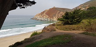
Gray Whale Cove State Beach is a California State Park between Pacifica, California, and Montara, California, by Highway 1 and approximately 18 miles south of San Francisco. It features a sheltered cove surrounded by abrupt cliffs, with trails connecting to nearby Montara Mountain and McNee Ranch State Park. It is located just south of Devil's Slide. The 3.1-acre (1.3 ha) park was established in 1966.
Rancho Corral de Tierra was a 7,766-acre (31.43 km2) Mexican land grant in present-day coastal western San Mateo County, northern California.

The Tom Lantos Tunnels are two tunnels located within the coastal promontory of Montara Mountain, on the San Francisco Peninsula in California, United States, created to allow rerouting State Route 1 to avoid a portion of roadway known as Devil's Slide. They are officially named after late Congressman Tom Lantos, who was instrumental in securing funding for the project, but de facto named after their location.

