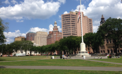
New Haven is a city in New Haven County, Connecticut, United States. It is located on New Haven Harbor on the northern shore of Long Island Sound and is part of the New York City metropolitan area. With a population of 135,081 as determined by the 2020 U.S. census, New Haven is the third largest city in Connecticut after Bridgeport and Stamford and the principal municipality of Greater New Haven, which had a total 2020 population of 864,835. Prior to 1960, it was the county seat of New Haven County until the county governments were abolished that year.

Wooster Square is a neighborhood in the city of New Haven, Connecticut to the east of downtown. The name refers to a park square located between Greene Street, Wooster Place, Chapel Street and Academy Street in the center of the neighborhood. Wooster Square is also known as Little Italy: a bastion of Italian American culture and cuisine, and is home to some of New Haven's, best-known pizza eateries, including Frank Pepe Pizzeria Napoletana and Sally's Apizza. The square and much of the neighborhood are included in the Wooster Square Historic District, which was listed on the National Register of Historic Places in 1971.

Midtown Atlanta, or Midtown, is a high-density commercial and residential neighborhood of Atlanta, Georgia. The exact geographical extent of the area is ill-defined due to differing definitions used by the city, residents, and local business groups. However, the commercial core of the area is anchored by a series of high-rise office buildings, condominiums, hotels, and high-end retail along Peachtree Street between North Avenue and 17th Street. Midtown, situated between Downtown to the south and Buckhead to the north, is the second-largest business district in Metro Atlanta. In 2011, Midtown had a resident population of 41,681 and a business population of 81,418.

Downtown Crossing is a shopping district within downtown Boston, Massachusetts, located east of Boston Common, west of the Financial District, south of Government Center, and north of Chinatown and the old Combat Zone. It features large department stores as well as restaurants, souvenir sellers, general retail establishments, and street vendors. The Downtown Crossing MBTA station lies in the center of the district.

Downtown Cleveland is the central business district of Cleveland, Ohio. The economic and symbolic center of the city and the Cleveland-Akron-Canton, OH Combined Statistical Area, it is Cleveland's oldest district, with its Public Square laid out by city founder General Moses Cleaveland in 1796.
Downtown is the central business district of Tacoma, Washington, United States, located in the inner Northeast section of the city. It is approximately bounded east-west by A Street and Tacoma Avenue, and north-south by South 7th Street and South 25th Street. The center of downtown is the intersection of 9th and Broadway.
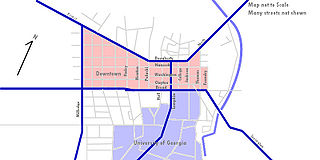
Downtown Athens is the oldest of the main commercial and residential centers in Athens, Georgia, United States. Downtown is generally considered to be the area bounded by Dougherty Street on the north, Broad Street and the University of Georgia campus on the south, Pulaski Street on the west, and Foundry Street by the east.
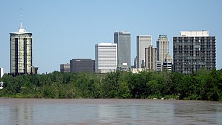
Tulsa is the second-largest city in the state of Oklahoma. It has many diverse neighborhoods due to its size.
The City of Oklahoma City uses Special Zoning Districts as a tool to maintain the character of many neighborhood communities.
Downtown Stamford, or Stamford Downtown, is the central business district of the city of Stamford, Connecticut, United States. It includes major retail establishments, a shopping mall, a university campus, the headquarters of major corporations and Fortune 500 companies, as well as other retail businesses, hotels, restaurants, offices, entertainment venues and high-rise apartment buildings.

Downtown Grand Forks is the original commercial center of Grand Forks, North Dakota. Located on the western bank of the Red River of the North, the downtown neighborhood is situated near the fork of the Red River and the Red Lake River. While downtown is no longer the dominant commercial area of the Greater Grand Forks community, it remains the historic center of Grand Forks. An 80.4-acre (32.5 ha) portion was listed on the National Register of Historic Places in 2005, as Downtown Grand Forks Historic District. Today, downtown Grand Forks is home to many offices, stores, restaurants, and bars.

Downtown Norfolk serves as the traditional center of commerce, government, and culture in the Hampton Roads region. Norfolk, Virginia's downtown waterfront shipping and port activities historically played host to numerous and often noxious port and shipping-related uses. With the advent of containerized shipping in the mid-19th century, the shipping uses located on Norfolk's downtown waterfront became obsolete as larger and more modern port facilities opened elsewhere in the region. The vacant piers and cargo warehouses eventually became a blight on downtown and Norfolk's fortunes as a whole. But in the second half of the century, Norfolk had a vibrant retail community in its suburbs; companies like Smith & Welton, High's, Colonial Stores, Goldman's Shoes, Lerner Shops, Hofheimer's, Giant Open Air, Dollar Tree and K & K Toys were regional leaders in their respective fields. Norfolk was also the birthplace of Econo-Travel, now Econo Lodge, one of the nation's first discount motel chains.
The city of San Antonio in the U.S. state of Texas is composed of a number of neighborhoods and districts, spreading out surrounding the central Downtown Area.

Downtown is the central economic, political, and cultural district of the city of Providence, Rhode Island. It is bounded on the east by Canal Street and the Providence River, to the north by Smith Street, to the west by Interstate 95, and to the south by Henderson Street. The highway serves as a physical barrier between the city's commercial core and neighborhoods of Federal Hill, West End, and Upper South Providence. Most of the downtown is listed on the National Register of Historic Places as the Downtown Providence Historic District.

Downtown Santa Ana (DTSA), also called Downtown Orange County, is the city center of Santa Ana, the county seat of Orange County, California. It is the institutional center for the city of Santa Ana as well as Orange County, a retail and business hub, and has in recent years developed rapidly as a regional cultural, entertainment and culinary center for Orange County.
Dixwell is a neighborhood of New Haven, Connecticut. Named for Dixwell Avenue, the main thoroughfare of the neighborhood which in turn was named for regicide judge John Dixwell, it is situated generally northwest of and adjacent to Downtown New Haven.

Downtown Austin is the central business district of Austin, Texas. Downtown is located on the north bank of the Colorado River. The approximate borders of Downtown include Lamar Boulevard to the west, Martin Luther King Jr. Boulevard and the University of Texas at Austin to the north, Interstate 35 to the east, and Lady Bird Lake to the south.

The Edw. Malley Co., often abbreviated Malley's, was a prestigious department store in Downtown New Haven, Connecticut, from 1852 to 1982. Company produced postcards promoted the establishment as "The Metropolitan Store of Connecticut". In 2007, it was ranked among the "landmark consumer paradises" of New Haven's past, along with Macy's, Shartenberg's Department Store, and Grant's. The second site was regarded as "a crucial appendage" to the success of the Chapel Square Mall.
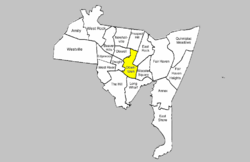
The city of New Haven, Connecticut has many distinct neighborhoods. In addition to Downtown, centered on the central business district and the Green, are the following neighborhoods: the west central neighborhoods of Dixwell and Dwight; the southern neighborhoods of The Hill, historic water-front City Point, and the harborside district of Long Wharf; the western neighborhoods of Edgewood, West River, Westville, Amity, and West Rock; East Rock, Cedar Hill, Prospect Hill, and Newhallville in the northern side of town; the east central neighborhoods of Mill River and Wooster Square, an Italian-American neighborhood; Fair Haven, an immigrant community located between the Mill and Quinnipiac rivers; Quinnipiac Meadows and Fair Haven Heights across the Quinnipiac River; and facing the eastern side of the harbor, The Annex and East Shore.

Downtown Rochester is the economic center of Rochester, New York, and the largest in Upstate New York, employing more than 50,000 people, and housing more than 6,000.