Cedar Hill (New Haven)

Last updated
View of East Rock and Indian Head from Cedar Hill Area (now Rice Field), 1898. Note the cedar trees in the background. Cedar hill.jpg
View of East Rock and Indian Head from Cedar Hill Area (now Rice Field), 1898. Note the cedar trees in the background.

Cedar Hill is a neighborhood in New Haven, Connecticut. It includes portions of the city-designated neighborhoods of East Rock, Quinnipiac Meadows, and Mill River. Cedar Hill was named for cedar trees that were once plentiful there in 1665. [1] The area was divided from the local surroundings by the construction of I-91 in the 1960s. Cedar Hill's boundary runs from James Street, up the Mill River, to Rice Field, over Indian Head Rock, to the Hamden town line, across to Middletown Avenue, to the Eastern side of State Street, back up to James Street. [2]

Contents

History

Early settlement

David Atwater was one of the earliest European settlers recorded living in Cedar Hill (at that time called the East Farm). [3] David Atwater, who died October 5, 1692, was the first of the New Haven Colony who was sworn a freeman of the united colony. [4] A farm [5] was assigned to him in the "Neck", the tract between the Mill and Quinnipiac Rivers. [6]

19th century

Prior to the mid-19th century, the Cedar Hill district remained one of the most undeveloped portions of New Haven. The earliest significant settlement of the district does not appear to have taken place until the mid or late 1840s. [7] An 1851 map shows that only about a dozen scattered houses and shops were standing in the area by that time. Virtually all of the buildings stood along or close to the area's two principal streets The Road to Wallingford (now known as upper State Street) and the Middletown Turnpike (now known as Middletown Avenue).

The few residents of the area during this period included M. Atwater, J. Matlby, R. Atwater and R. Augur. Major Lyman Atwater (Lyman Street was named after him) and son Lyman Hotchkiss Atwater also were born and lived in Cedar hill. Elias B. Bishop married the Major's daughter Grace (Grace Street in Cedar Hill is named after her; at one time it was the road around the bottom of East Rock and is now partly called Rock Street and English Drive [8] ) and bought the Atwater House on State Street, Cedar Hill from the Major when he moved to Vermont. Henry Eld [9] had lived in the area now known as View Street, but when it started becoming more populated he relocated. Charles A. Warren President of the State Street House Railroad Company took over the property his office was at 82G Grand Street, Atwater building. [10] [11]

In 1818 Asclepias lanceolata, which is now called Asclepias viridiflora, was discovered in Cedar Hill by Dr. Eli Ives in 1779. [12]

From the late 1860s through the 1890s most of the development was residential and concentrated it that portion of the area which lay near the junction of State Street and Middletown Avenue.

Rock Street, one of the gateway streets going into East Rock Park, was built in or around 1875. It was originally called the Highway to the top of East Rock. Charles Warren and Charles Blatchley developed the Road. Warren Place in the Cedar Hill was named after Charles Warren. The beginning of the street is now a residential area but the better part of it is now closed to cars but can be hiked up to the top of East Rock. [13]

Rock Street Brewery, Cedar Hill, New Haven, CT The Brewery burned down in the 1890s. Rock brewery 001.jpg
Rock Street Brewery, Cedar Hill, New Haven, CT The Brewery burned down in the 1890s.
George Basserman apartment building at 1395 State Street Basserman.jpg
George Basserman apartment building at 1395 State Street

One of the more important light industry built in the area was the Rock Street Brewing Company, [14] owned by George Basserman. Basserman's Rock Brewery on State Street. The brewery took its name from Snake Rock, an extension of East Rock. Basserman owned the brewery and the adjacent apartment building, which still stands on the corner of Rock and 1395 State Street. He sold the property in 1888 to John M. Manning of Buffalo, a brother of the late Daniel Manning. He had plans to enlarge it, before the fire. [15] No exact date of its closing can be found but there is record of a fire in the 1930s.

Until the late 19th century, Cedar Hill was an area of Hamden. [16] [17] When the railyards were built, it was incorporated into New Haven's Fair Haven neighborhood.

20th century

The most significant feature of the area's development during the first half of the 20th century was the construction of the Cedar Hill Yard in the central part of the district between State Street and Middletown Avenue.

Begun in 1909 as part of an effort by the New York, New Haven and Hartford Railroad, during the building of the new railyard in Cedar Hill rail men wanted to strike, [18] but were able to get the extra pay to work all the hours the construction of the yard would require. Cedar Hill Yards had 14 yards of the 25 that were in New Haven at the time. The railyard could hold over 15,000 cars at a time. [19] The trolleys were stored in what is now the Connecticut Transit Bus Terminal. The building still stands virtually unchanged from when it housed trolleys. Even though the railyards are now all but empty, they still are a dominant part of the central part of the Cedar Hill District.

The development of Cedar Hill continued at a gradual pace through the early years of the 20th century. Most of the residents of Cedar Hill Avenue at that time were there to help with the Ferry Street Congregational Church work. Grace, May and Cedar Hill Avenues were laid out in the Reconstruction Era. These houses were constructed for the working men of the burgeoning manufacturing industries in the adjacent Fair Haven neighborhood. [20]

The National Folding Box & Paper Co. is on James Street across from the Cedar Hill Station (car barn when there were trolleys), and both buildings still stand today. City lines at the time defined this area as Cedar Hill. It was a large factory for its time, a four-story building over 240,000 sq ft (22,000 m2). Over 22,629 people were employed there. The Bridgeport branch had 23,343. This showed that Bridgeport was the largest manufacturing city in the State during this time, but New Haven was a close second. [21]

Although the economic character of Cedar Hill changed gradually, the architectural complexion of the area appears to have changed little since the late 1940s. The best remaining example of scattered commercial structures built in Cedar Hill is the Michael W. Ferrell Building at 1296-1304 State Street. Mostly brick structures were popping up around the area. An excellent example would also be the John H. Slator Building (built and owned by John Slator, President of the Masons at the time), a late 19th-century Italianate style detached duplex row house at 1515-1517 State Street. [22] And is a registered historical home.

Present time

Up until the 2002 Cedar Hill was part of the Fair Haven District of New Haven. [23] [ failed verification ] The community members in 2000 (based on the finds of the 2000 census) were asked to vote what district they wanted to be part of because of census results requiring New Haven to redistrict before elections of 2002, [24] [ failed verification ] they became part of the East Rock district because of the shift of the congressional districts. [25] [ failed verification ]

Cedar Hill streets, past and present

Map of the missing streets from the construction of I-95 in the 1950s; also note the Cedar Hill Depot for the trolleys now housing the CT Transit 1890map.jpg
Map of the missing streets from the construction of I-95 in the 1950s; also note the Cedar Hill Depot for the trolleys now housing the CT Transit

This is a list of the original streets of Cedar Hill. When I-95 was built some were removed (marked as gone); see map. The importance of this is that the community is now isolated from its communities on all sides, stalling city services from getting to it. Three other communities in New Haven were isolated in the same way: Mill River, City Point and part of the Annex.

Present streets:

Partially removed streets:

Streets removed:

Landmarks

Ferry Street truss bridge in Cedar Hill Ferry Street Railroad Bridge.jpg
Ferry Street truss bridge in Cedar Hill
Between 1910 and 1913, the railroad built a large new classification yard in the northeast part of New Haven, the Cedar Hill Terminal, in order to consolidate and expand its freight operations. In connection with that work, the railroad right-of-way was then further widened to accommodate more tracks, and electrification was extended to the new Cedar Hill yards. [26] The widening required a new bridge at Ferry Street. The bridge was entirely paid for by the railroad with the exception of $316.92 paid by the city of New Haven for a temporary bridge during construction. [27]
Cedar Hill Coal Tower Coaling tower in Cedar Hill Yard, August 2022.JPG
Cedar Hill Coal Tower
Bishop Gate - State Street Cedar Hill, New Haven, CT - First road to East Rock the trolley used to take people to it. Bishop gate.jpg
Bishop Gate - State Street Cedar Hill, New Haven, CT - First road to East Rock the trolley used to take people to it.
Snake Rock contains a half-emerged laccolith, its summit exposed, but with the western wall of sandstone still standing and overtopping the trap. The sandstone shows everywhere the effects of metamorphism, and before industrial encroachments on the rock in the 19th century there was a prominence of columnar sandstone in the southwestern bluff. [30]

Related Research Articles

<span class="mw-page-title-main">New Haven, Connecticut</span> City in Connecticut, United States

New Haven is a city in New Haven County, Connecticut, United States. It is located on New Haven Harbor on the northern shore of Long Island Sound and is part of the New York City metropolitan area. With a population of 135,081 as determined by the 2020 U.S. census, New Haven is the third largest city in Connecticut after Bridgeport and Stamford, the largest city in the South Central Connecticut Planning Region, and the principal municipality of Greater New Haven, which had a total population of 864,835 in 2020. Prior to 1960, it was the county seat of New Haven County until the county governments were abolished that year.

<span class="mw-page-title-main">Middletown, Connecticut</span> City in Connecticut, United States

Middletown is a city in Middlesex County, Connecticut, United States. Located along the Connecticut River, in the central part of the state, it is 16 miles south of Hartford. Middletown is the largest city in the Lower Connecticut River Valley Planning Region. In 1650, it was incorporated by English settlers as a town under its original Native American name, Mattabeseck, after the local indigenous people, also known as the Mattabesett. They were among the many tribes along the Atlantic coast who spoke Algonquian languages. The colonists renamed the settlement in 1653.

<span class="mw-page-title-main">Fair Haven, New Haven</span> Neighborhood of New Haven in Connecticut, United States

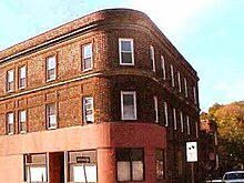
Fair Haven is a neighborhood in the eastern part of the city of New Haven, Connecticut, between the Mill and Quinnipiac rivers. The northeast section of the neighborhood is also known as Chatham Square.

<span class="mw-page-title-main">Union Station (New Haven)</span> Railroad station in Connecticut

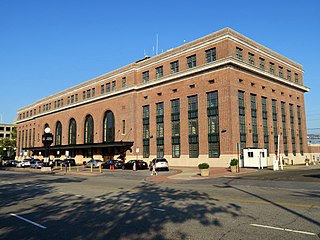
Union Station, also known as New Haven Railroad Station or simply New Haven, is the main railroad passenger station in New Haven, Connecticut. It is the third such station in the city of New Haven, preceded by both an 1848 built station in a different location, and an 1879 built station near the current station's location. Designed by noted American architect Cass Gilbert, the present beaux-arts Union Station was completed and opened in 1920 after the previous Union Station was destroyed by fire. It served the New York, New Haven and Hartford Railroad for the next five decades, but fell into decline following World War II along with the United States railroad industry as a whole.

<span class="mw-page-title-main">East Rock, New Haven</span> Neighborhood of New Haven in Connecticut, United States

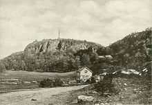
East Rock is a neighborhood in the city of New Haven, Connecticut, named for nearby East Rock, a prominent trap rock ridge. The area is home to a large group of Yale students, staff, and faculty, as well as many young professionals and families. Writing in the Times Literary Supplement, Hirsh Sawhney describes East Rock as a "yuppie enclave", which is "increasingly composed of wealthy professionals and graduate students, most of whom are affiliated with Yale University, whose lavish campus lies just over a mile away" East Rock is also a popular destination for cyclists, as a city bike lane runs along Orange Street, the neighborhood's spine. East Rock is the safest neighborhood in New Haven County. East Rock is home to East Rock Park, which is frequently visited by families and tourists.

<span class="mw-page-title-main">Danbury Railway Museum</span> United States historic place

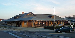
The Danbury Railway Museum is a railway museum housed in the former Union Station on the east end of downtown Danbury, Connecticut, United States. It was established in the mid-1990s following the closure of the station by the Metro-North Railroad in favor of a new station nearby, and primarily focuses on the history of railroading in southern New England and neighboring New York. In addition to the former station building, the museum has a collection of heritage railcars in the neighboring rail yard it shares with Metro-North.

<span class="mw-page-title-main">Connecticut Southern Railroad</span> Freight railroad in Connecticut and Massachusetts

The Connecticut Southern Railroad is a 90-mile (140 km) long short-line railroad operating in Connecticut and Massachusetts. The company was formed in 1996 as a spinoff of Conrail by shortline holding company RailTex and subsequently acquired in 2000 by RailAmerica. Since 2012, it has been a subsidiary of Genesee & Wyoming. CSO is headquartered in Hartford, Connecticut, site of its Hartford Yard. The company also operates East Hartford Yard.

<span class="mw-page-title-main">History of Norwalk, Connecticut</span>

The history of Norwalk, Connecticut ranges from pre-contact cultures and Native Americans to the 21st century.

<span class="mw-page-title-main">Connecticut Company</span>

The Connecticut Company was the primary electric street railway company in the U.S. state of Connecticut, operating both city and rural trolleys and freight service. It was controlled by the New York, New Haven and Hartford Railroad, which also controlled most steam railroads in the state. After 1936, when one of its major leases was dissolved, it continued operating streetcars and, increasingly, buses in certain Connecticut cities until 1976, when its assets were purchased by the state government.

East Rock Park is a park in the city of New Haven and the town of Hamden, Connecticut that is operated as a New Haven city park. The park surrounds and includes the mountainous ridge named East Rock and was developed with naturalistic landscaping. The entire 427-acre (173 ha) park is listed on the National Register of Historic Places.

<span class="mw-page-title-main">Glenbrook station (Metro-North)</span> Metro-North Railroad station in Connecticut

Glenbrook station is a commuter rail stop on the New Canaan Branch of the Metro-North Railroad's New Haven Line, located in the Glenbrook section of Stamford, Connecticut.

<span class="mw-page-title-main">George Basserman</span>

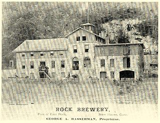
George Anton Basserman was a noted brewery owner in the Cedar Hill neighborhood of New Haven, Connecticut during the late 19th century. Born in what is now Germany in 1832, and came to New Haven in 1851.

<span class="mw-page-title-main">Howard Avenue Historic District</span> Historic district in Connecticut, United States

The Howard Avenue Historic District is a 32-acre (13 ha) historic district in The Hill neighborhood of the city of New Haven, Connecticut. Extending along Howard Avenue between Minor Street and Interstate 95, it contains an unusually high concentration of well-preserved late 19th-century middle class vernacular architecture, reflecting the area's growth at that time. It was listed on the National Register of Historic Places in 1985.

The city of New Haven, Connecticut has many distinct neighborhoods. In addition to Downtown, centered on the central business district and the Green, are the following neighborhoods: the west central neighborhoods of Dixwell and Dwight; the southern neighborhoods of The Hill, historic water-front City Point, and the harborside district of Long Wharf; the western neighborhoods of Edgewood, West River, Westville, Amity, and West Rock; East Rock, Cedar Hill, Prospect Hill, and Newhallville in the northern side of town; the east central neighborhoods of Mill River and Wooster Square, an Italian-American neighborhood; Fair Haven, an immigrant community located between the Mill and Quinnipiac rivers; Quinnipiac Meadows and Fair Haven Heights across the Quinnipiac River; and facing the eastern side of the harbor, The Annex and East Shore.

<span class="mw-page-title-main">David Atwater</span>

David Atwater was a founder of the Colony of New Haven, Connecticut. He was the first of the New Haven Colony who was sworn a freeman of the United Colony.

<span class="mw-page-title-main">Connecticut Valley Railroad</span> Defunct railroad in Connecticut

The Connecticut Valley Railroad was a railroad in the state of Connecticut founded in 1868. The company built a line along the Connecticut River between Hartford and Old Saybrook, which opened in 1871. It was reorganized as the Hartford and Connecticut Valley Railroad in 1880, and leased by the New York, New Haven and Hartford Railroad in 1887. Following partial abandonments by the New Haven Railroad and successor Penn Central Transportation Company between 1968 and 1972, the line south of Middletown was revived as the Valley Railroad, a heritage railroad, while the portion in Middletown and northward saw operation by several freight railroads. As of 2022, the Providence and Worcester Railroad and Connecticut Southern Railroad both operate portions of the former Connecticut Valley Railroad.

<span class="mw-page-title-main">Sidney Mason Stone</span> American architect (1803–1882)

Sidney Mason Stone was a prominent Connecticut architect and builder known for designs of churches, institutional buildings and residences. His creations incorporated Greek Revival, Romanesque, Gothic, Italianate and other styles popular in the 19th century. He served in several civic capacities in the city of New Haven and statewide and as mentor to Yale students prior to the establishment of that university's School of Architecture. He was the father of Harriet Mulford Stone, better known to readers of children's literature as Margaret Sidney, creator of the Five Little Peppers series.

<span class="mw-page-title-main">Cedar Hill Yard</span> Railway yard in New Haven, Connecticut, US

Cedar Hill Yard is a classification yard located in New Haven, North Haven and Hamden, Connecticut, United States. It was built by the New York, New Haven and Hartford Railroad in the early 1890s in and around New Haven's Cedar Hill neighborhood, which gave the yard its name. Electrical catenary for electric locomotives was added to the yard in 1915. To handle increasing traffic as a result of World War I, the yard was greatly expanded between 1917 and 1920 with additional construction along both sides of the Quinnipiac River. The construction project added two humps where railroad cars were sorted into trains by gravity. The yard was further modernized in the 1920s, becoming one of the busiest railroad yards in the United States, and the most important yard in the entire New Haven Railroad system.

<span class="mw-page-title-main">Meriden, Waterbury and Connecticut River Railroad</span> Railroad in Connecticut (1885–1892)

The Meriden, Waterbury, and Connecticut River Railroad was a railroad in the state of Connecticut. The charter, originally granted in 1871 to the Meriden and Cromwell Railroad, was obtained by Meriden residents and construction began in 1883. The line opened between the city of Meriden, Connecticut, and the Connecticut River in Cromwell, Connecticut, in 1885. An extension to Waterbury, Connecticut, was completed in 1888 as the Meriden and Waterbury Railroad, and the two companies merged to form the Meriden, Waterbury and Connecticut Railroad.

References

  1. Cutter, William Richard (1910). Genealogical and Personal Memoirs Relating to the Families of the State of Massachusetts. Lewis historical Publishing Company.
  2. http://www.cityofnewhaven.com/CityPlan/pdfs/HistoricInventory/NH%20HRI%203%20Cedar%20Hill.pdf Archived 2016-03-04 at the Wayback Machine [ bare URL PDF ]
  3. Francis Atwater, Atwater History and Genealogy , Journal Publishing Company, Meriden, Conn. 1907
  4. Barber, John Warner (1831). History and antiquities of New Haven (Conn.) from its earliest settlement to the present time. Prelinger Library. New Haven, J.W. Barber.
  5. Bartlett, Ellen Strong (1897). Historical sketches of New Haven. University of California Libraries. New Haven, Printed by Tuttle, Morehouse & Taylor.
  6. Society, New Haven Colony Historical (1894). Papers of the New Haven Colony Historical Society.
  7. Society, New Haven Colony Historical (1894). Papers of the New Haven Colony Historical Society.
  8. http://lcweb2.loc.gov/cgi-bin/map_item.pl%5B%5D The city of New Haven, Conn. 1879. Drawn & pub. by O. H. Bailey & J. C. Hazen
  9. http://images.lib.uconn.edu/cdm4/item_viewer.php?CISOROOT=%2Fcho&CISOPTR=16457&DMSCALE=100.00000&DMWIDTH=750&DMHEIGHT=807.121771218&DMMODE=viewer&DMFULL=0&DMOLDSCALE=2.05733&DMX=0&DMY=0&DMTEXT=%2520new%2520haven%2520map&DMTHUMB=1&REC=9&DMROTATE=0&x=104&y=43 Archived 2011-07-20 at the Wayback Machine Map of where Henry Eld's house was in Cedar Hill
  10. Greenough, Jones & Co's New Directory of the Inhabitants, Institutions, Manufacturing Establishments, Business, Societies, Business Firms, Etc. Etc. in the City and Town of New Haven for ... Greenough, Jones & Company, compilers and publishers. 1874.
  11. LLC., Historic Map Works. "Fair Haven Plan, Atlas: New Haven County 1868, Connecticut Historical Map". www.historicmapworks.com. Archived from the original on 2016-03-04. Retrieved 2016-04-12.
  12. American Journal of Science and Arts. Kline Geology Laboratory, Yale University. 1818.
  13. Haven (Conn.), New (1887). Municipal Year Book.
  14. Battista, Carolyn (1998-12-13). "New Haven, a City Of Beer Making (Until Prohibition)". The New York Times. ISSN   0362-4331 . Retrieved 2023-02-17.
  15. "Meriden Daily Republican - Google News Archive Search". Archived from the original on 2022-09-05. Retrieved 2016-09-20.
  16. Atwater, Francis; Attwater, Charles Hobart (1901). Atwater history and genealogy. New York Public Library. Meriden, Conn., Journal Pub. Co.
  17. Townshend, Charles Hervey (1879-01-01). The British Invasion of New Haven, Connecticut: Together with Some Account of Their Landing and Burning the Towns of Fairfield and Norwalk, July, 1779. publisher not identified.
  18. "Sunday Herald - Google News Archive Search". news.google.com. Retrieved 2023-02-17.
  19. ww25.kinglyheirs.com http://ww25.kinglyheirs.com/AbandonedRR/CedarHill1.html?subid1=20230218-0038-534a-b290-7f9bf02ca223 . Retrieved 2023-02-17.{{cite web}}: Missing or empty |title= (help)
  20. "New Haven Museum" . Retrieved 2023-02-17.
  21. Connecticut (1906). Public Documents of the State of Connecticut. order of the General Assembly.
  22. Benham's New Haven City Directory Also, the Annual Advertiser. Price & Lee Company. 1899.
  23. "New Haven E. / (D.H. Hurd & Co.) / 1893". www.davidrumsey.com. Retrieved 2023-02-17.
  24. http://www.cityofnewhaven.com/CityPlan/pdfs/AnnualReports/AnnualReport02.pdf Archived 2012-03-29 at the Wayback Machine City of New Haven Annual Report
  25. http://www.cityofnewhaven.com/CityPlan/pdfs/Maps/NeighborhoodPlanningMaps/East_Rock.pdf Archived 2007-09-28 at the Wayback Machine 1990 map of East Rock District, Cedar Hill included
  26. "photos". Archived from the original on 2012-02-24. Retrieved 2019-11-02.
  27. "Ferry Street Railroad Bridge, Ferry Street over New Haven Railroad, New Haven, New Haven County, CT". www.loc.gov. Retrieved 2023-02-17.
  28. (Conn.), New Haven (1898-01-01). Charter and Ordinances of the City of New Haven: Together with Legislative Acts Affecting Said City. Press of the Price, Lee & Adkins Company.
  29. Wittemann, Adolph (1897-01-01). East Rock Park at New Haven, Conn. A. Wittemann.
  30. Dana, James Dwight (1891-01-01). On the Four Rocks of the New Haven Region, East Rock, West Rock, Pine Rock, and Mill Rock, in Illustration of the Features of Non-volcanic Igneous Ejections: With a Guide to Walks and Drives about New Haven. Tuttle, Morehouse & Taylor, printers.

Bibliography

For researchers

41°19′21″N72°53′42″W / 41.32250°N 72.89500°W / 41.32250; -72.89500