Related Research Articles

New Haven County is a county in the south central part of the U.S. state of Connecticut. As of the 2010 census, the population was 862,477 making it the third-most populous county in Connecticut. Two of the state's largest cities, New Haven (2nd) and Waterbury (5th), are part of New Haven County.
U.S. Route 5 is a north–south United States highway running through the New England states of Connecticut, Massachusetts, and Vermont. Significant cities along the route include New Haven, Connecticut; Hartford, Connecticut; and Springfield, Massachusetts. From Hartford northward to St. Johnsbury, Vermont, the road closely follows the route of the Connecticut River.

New Haven Harbor is an inlet on the north side of Long Island Sound in the state of Connecticut in the United States. The harbor area is an inlet carved by the retreat of the glaciers during the last ice age approximately 13,000 years ago.

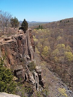
Regicides Trail is a Blue-Blazed hiking trail, about 7 miles (11 km) long, roughly following the edge of a diabase, or traprock, cliff northwest of New Haven, Connecticut. It is named for two regicides, Edward Whalley and his son-in-law William Goffe, who signed the death warrant of King Charles I of England. Upon the restoration of Charles II to the throne and the persecution of the regicides, the pair hid in Judges Cave near the south end of the trail in 1660. The Regicides is widely known to be one of the most technical trails within the CT Blue-Blazed trail system.

Fair Haven is a neighborhood in the eastern part of the city of New Haven, Connecticut, between the Mill and Quinnipiac rivers. The northeast section of the neighborhood is also known as Chatham Square.
The Flats is a neighborhood located in the southeastern end of Woodbridge, Connecticut, in the West River valley Amity area that runs between the hilly western part of town and the rock formation known as West Rock. It also borders the city of New Haven, and specifically the neighborhood of Westville. The valley of Amity is an area located partly in the town of Woodbridge, Connecticut and partly in the city of New Haven. It is bounded on the northeast by the West Rock Ridge, on the south by the Westville neighborhood of New Haven, and on the northwest by an incline in elevation above which lies the highlands of Woodbridge, Connecticut. This region was called “Shushuck” by Native Americans.
Fair Haven Heights, or simply the Heights, is a residential and light industrial neighborhood in the eastern part of the city of New Haven, Connecticut, located east of the Quinnipiac River. Fair Haven Heights is not to be confused with the adjacent Fair Haven neighborhood west of the river. The area is bordered on the west by the Quinnipiac River, on the north by Route 80, on the east by the town of East Haven, and on the south by Ferry Street and Warwick Avenue. The main through routes are Quinnipiac Avenue, East Grand Avenue, and Eastern Street

Connecticut Route 80 is a 25.9 mile highway that runs through south-central Connecticut. The west end is at CT 17 in Quinnipiac Meadows neighborhood of New Haven, and the east end is at CT 154 in Deep River. Route 80 runs within 5 miles of many town squares- including Downtown New Haven.
The valley of Amity is an area located partly in the towns of Woodbridge, Bethany, and Orange, Connecticut and partly in the city of New Haven. It is bounded on the northeast by the West Rock ridge, on the south by the Westville neighborhood of New Haven, and on the northwest by an incline in elevation above which lies the highlands of Woodbridge, Connecticut. The official New Haven neighborhood planning maps include the traditionally separate neighborhoods of West Hills and Beverly Hills within the Amity neighborhood.

Route 103 is a state highway in Connecticut running from the Quinnipiac Meadows neighborhood in New Haven, through the Montowese area of North Haven, ending at the town center of North Haven.

Cedar Hill is a neighborhood in New Haven, Connecticut. It includes portions of the city-designated neighborhoods of East Rock, Quinnipiac Meadows, and Mill River. Cedar Hill was named for cedar trees that were once plentiful there in 1665. The area was divided from the local surroundings by the construction of I-91 in the 1960s. Cedar Hill's boundary runs from James Street, up the Mill River, to Rice Field, over Indian Head Rock, to the Hamden town line, across to Middletown Avenue, to the Eastern side of State Street, back up to James Street.
Mill River is a primarily industrial neighborhood in the city of New Haven, Connecticut located between the Wooster Square and Fair Haven neighborhoods.

U.S. Route 5 (US 5), a north–south U.S. Highway that is generally paralleled by Interstate 91 (I-91), begins at the city of New Haven in Connecticut and heads north through western Massachusetts and eastern Vermont to the international border with Canada. Within Connecticut, US 5 proceeds north from New Haven and passes through Meriden and Hartford towards Springfield, Massachusetts.

Bradley Mountain, 700 feet (210 m), is a traprock mountain located 3 miles (5 km) west of New Britain, Connecticut, United States, in the towns of Southington and Plainville. It is part of the narrow, linear Metacomet Ridge that extends from Long Island Sound near New Haven, Connecticut, north through the Connecticut River Valley of Massachusetts to the Vermont border. Bradley Mountain, popular as an outdoor recreation destination in the metropolitan Hartford/ New Britain area, is known for its clifftop scenic vistas overlooking Plainville Reservoir, unique microclimate ecosystems, and rare plant communities. Bradley Mountain is traversed by the 62.7-mile (101 km) Metacomet Trail.
The Quinnipiac Trail is a 24-mile (39 km) Blue-Blazed hiking trail in New Haven County, Connecticut. It is the product of the evolution and growth of the first 10.6-mile (17.1 km) trail designated in Connecticut's Blue-Blazed Hiking Trail system, with its light-blue rectangular vertical painted blazes.
The Annex is a residential neighborhood in the city of New Haven, Connecticut. Originally part of East Haven, the neighborhood was voluntarily ceded by East Haven and annexed by the city of New Haven in the 1880s. It is located on the eastern side of New Haven Harbor across from Long Wharf. The City of New Haven defines the neighborhood to be the region bounded by Upson Terrace and East Shore Park on the south, the city of East Haven on the east, Warwick Street and East Ferry Street on the northeast, the Quinnipiac River on the northwest, and New Haven Harbor on the west.
The city of New Haven, Connecticut has many distinct neighborhoods. In addition to Downtown, centered on the central business district and the Green, are the following neighborhoods: the west central neighborhoods of Dixwell and Dwight; the southern neighborhoods of The Hill, historic water-front City Point, and the harborside district of Long Wharf; the western neighborhoods of Edgewood, West River, Westville, Amity, and West Rock; East Rock, Cedar Hill, Prospect Hill, and Newhallville in the northern side of town; the east central neighborhoods of Mill River and Wooster Square, an Italian-American neighborhood; Fair Haven, an immigrant community located between the Mill and Quinnipiac rivers; Quinnipiac Meadows and Fair Haven Heights across the Quinnipiac River; and facing the eastern side of the harbor, The Annex and East Shore.
Whitney Avenue is a principal arterial connecting Downtown New Haven with the town center of Hamden in the U.S. state of Connecticut. Most of the road within the city of New Haven is included in the Whitney Avenue Historic District, which is listed on the National Register of Historic Places. The designation begins at Grove Street in the northern part of Downtown New Haven and extends through the town of Hamden up to the Cheshire town line. North of Dixwell Avenue in Hamden Center, the road is a state highway and designated as part of Route 10. From the New Haven town line to Dixwell Avenue, the road is state-maintained with an unsigned designation of State Road 707. Within New Haven, Whitney Avenue is a town road. The J route of Connecticut Transit New Haven, which connects New Haven to Waterbury, runs along Whitney Avenue.
The North Haven Mall was a shopping mall proposed for construction in North Haven, Connecticut.
Grannis Island is an uninhabited island in the Quinnipiac River in New Haven, Connecticut. It is owned by the New Haven Land Trust as part of the Eugene B. Fargeorge Nature Preserve at Quinnipiac Meadows
References
- ↑ Quinnipiac Meadows (PDF) (Map). New Haven City Plan Department. Retrieved 2009-02-06.