
The Fan is a district of Richmond, Virginia, so named because of the "fan" shape of the array of streets that extend west from Belvidere Street, on the eastern edge of Monroe Park, westward to Arthur Ashe Boulevard. However, the streets rapidly resemble a grid after they go through what is now Virginia Commonwealth University. The Fan is one of the easterly points of the city's West End section, and is bordered to the north by Broad Street and to the south by VA 195, although the Fan District Association considers the southern border to be the properties abutting the south side of Main Street. The western side is sometimes called the Upper Fan and the eastern side the Lower Fan, though confusingly the Uptown district is located near VCU in the Lower Fan. Many cafes and locally owned restaurants are located here, as well as historic Monument Avenue, a boulevard formerly featuring statuary of the Civil War's Confederate president and generals. The only current statue is a more modern one of tennis icon Arthur Ashe. Development of the Fan district was strongly influenced by the City Beautiful movement of the late 19th century.

Park Place is a neighborhood in the western half of Norfolk, Virginia. Its boundaries are roughly Granby Street on the east, Colley Avenue on the west, 23rd Street on the south and up to 38th Street to the north. Within these boundaries Park Place is made up of 4 historic subdivisions; Virginia Place, East Kensington, Park Place, and East Old Dominion Place.

Lyon Village is a neighborhood, or "urban village" located in Arlington County, Virginia, along Langston Boulevard. It adjoins Arlington County's government center, and is approximately one mile west of Rosslyn and less than a mile north of Clarendon, of which it is sometimes considered a sub-neighborhood, as is Cherrydale, the mostly residential district immediately west of Lyon Village.
The Julia-Ann Square Historic District, is a national historic district located at Parkersburg, Wood County, West Virginia. It is to the west of the Avery Street Historic District. It encompasses all houses on Ann and Juliana Streets from Riverview Cemetery to 9th Street. There are 116 contributing buildings and one contributing site. The majority of the houses were constructed between 1875 and 1915.
In the United States, the National Register of Historic Places classifies its listings by various types of architecture. Listed properties often are given one or more of 40 standard architectural style classifications that appear in the National Register Information System (NRIS) database. Other properties are given a custom architectural description with "vernacular" or other qualifiers, and others have no style classification. Many National Register-listed properties do not fit into the several categories listed here, or they fit into more specialized subcategories.

The Cork Hill District is a nationally recognized historic district located in Davenport, Iowa, United States. It was listed on the National Register of Historic Places in 1984. The historic district covers 18.7-acre (7.6 ha) and stretches from the campus of Palmer College of Chiropractic on the west to the Sacred Heart Cathedral Complex on the east. It is the western half of a neighborhood of the same name. When listed, the district included 12 contributing buildings. It includes Greek Revival, Italianate, and Victorian architecture. The district was covered in a 1982 study of the Davenport Multiple Resource Area and/or its 1983 follow-on.

The Downtown Morgantown Historic District is a federally designated historic district in Morgantown, Monongalia County, West Virginia. The district, encompassing approximately 75 acres, has 122 contributing buildings and 2 contributing sites including commercial and public buildings, residences, and churches. The district has been listed on the National Register of Historic Places since May 2, 1996. Ten of the contributing buildings are listed separately on the National Register of Historic Places. Significant structures located within the historic district are the Monongalia County Courthouse, the Metropolitan Theater, and the Old Morgantown Post Office.
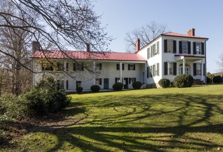
"Walnut Grove", also known as the Andrew Beirne House, is a historic home located near Union, Monroe County, West Virginia. It is a "T" shaped dwelling that integrates four separate structures. The oldest date to the 1780s and incorporates two, two-story log buildings. Attached to them is a formerly detached log kitchen. A two-story, Greek Revival-style brick addition was built after 1825. The entrance is in this section and features a one-story porch supported by square columns. Also on the property are a two-room frame office building, brick smokehouse, and stone springhouse. It was home to U.S. Congressman Andrew Beirne (1771–1845).

The Sixth and Forest Historic District is located in Des Moines, Iowa, United States. It is a Victorian era suburban commercial district on the northeastern and northwestern corners of the junction of 6th and Forest Avenues, and originally contained six buildings. The buildings on the northeast corner have subsequently been torn down. The historic district has been listed on the National Register of Historic Places since 1996. It is a part of the Towards a Greater Des Moines MPS.
The Maywood Historic District is a national historic district located in Arlington County, Virginia. It contains 198 contributing buildings in a residential neighborhood located in the northern part of the county. The area was platted and subdivided in five sections between 1909 and 1913 following the arrival in 1906 of the Great Falls and Old Dominion Railroad. The area was primarily developed between 1909 and 1929. The dwelling styles include a variety of architectural styles, including Queen Anne, Colonial Revival foursquares, Bungalow, and two-story gable-front houses. Several dwellings in the neighborhood have been identified as prefabricated mail-order houses.

Ashton Heights Historic District is a national historic district located in Arlington County, Virginia. Today, the Ashton Height Historic District contains 1,097 contributing buildings, one contributing site, and one contributing structure in a residential neighborhood in North Arlington.

The Arlington Heights Historic District is a national historic district located at Arlington County, Virginia. It contains 737 contributing buildings and 1 contributing site in a residential neighborhood in central Arlington. The area was formed from the integration of twenty-five subdivisions platted between 1909 and 1978. Single-family dwellings include representative examples of the Tudor Revival and Colonial Revival styles. The district is primarily a single-family residential neighborhood with a number of twin dwellings, is also home to garden apartments, one high-rise apartment building, a commercial building, a synagogue, a parsonage, a middle school with community center, and two landscaped parks.

Highland Park–Overlee Knolls, also known as Fostoria, is a national historic district located in Arlington County, Virginia. It is directly east of the Virginia Heights Historic District. It contains 681 contributing buildings, 3 contributing sites, and 1 contributing structure in a residential neighborhood in North Arlington. The first subdivision was platted in 1890 and known as Fostoria.

The West Freemason Street Area Historic District is a national historic district located at Norfolk, Virginia. It encompasses 48 contributing buildings in a primarily residential section on the western edge of the center city of Norfolk. It developed between the late-18th and early-20th centuries and includes notable examples of the Federal, Greek Revival, and Late Victorian styles. Notable buildings include Kenmure House Glisson House, Whittle House, McCullough Row, and the Camp-Hubard house. Located in the district is the separately listed Allmand-Archer House.

The West Franklin Street Historic District is a national historic district located at Richmond, Virginia. It is located along the northern boundary of the Fan district. The district encompasses 71 contributing buildings built between about 1870 and the 1920. It was originally developed as a primarily residential district with buildings in a variety of popular late-19th and early-20th century architectural styles including Greek Revival, Romanesque, Georgian Revival, Queen Anne, and Italianate. Many of the dwellings have been converted to commercial use. In addition, the district's private houses have been converted into multi-family housing and departmental offices for Virginia Commonwealth University. Notable buildings include Franklin Terrace, the Ritter-Hickock House, First Independent Church, Founder's Hall, the Raleigh Building, The Greyston Apartments, Gresham Court Apartments, and the Beth Ahabah Congregation Hall and Synagogue.

The Two Hundred Block West Franklin Street Historic District is a national historic district located at Richmond, Virginia. It is located between downtown and the Fan district. The district encompasses 13 contributing buildings built during the 19th century and in a variety of popular architectural styles including Greek Revival, Federal, Beaux-Arts, and Queen Anne. Many of the dwellings have been converted to commercial use. Notable buildings include Queen Anne Row (1891), the Carter-Mayo House designed by Carrère and Hastings, the Cole Diggs House, the Smith-Palmer House, the Ida Schoolcraft House, the Price House, the A. S. Smith House, and the T. Seddon Bruce House.

The Laburnum Park Historic District is a national historic district located at Richmond, Virginia. The district encompasses 226 contributing buildings and 2 contributing structures located north of downtown Richmond. The primarily residential area developed starting in the early-20th century as one of the city's early "streetcar suburbs" and as home to several important local institutions. The buildings are in a variety of popular early-20th century architectural styles including Queen Anne and Colonial Revival. It was developed as neighborhood of middle-to-upper-class, single-family dwellings. Notable buildings include the Laburnum House (1908), Richmond Memorial Hospital (1954-1957), Richmond Memorial Hospital Nursing School (1960-1961), "The Hermitage" (1911), Laburnum Court (1919), Veritas School.
Luna Park Historic District is a federally designated national historic district located in the West Side neighborhood of Charleston, Kanawha County, West Virginia. It encompasses 444 contributing buildings in a predominantly residential section of Charleston. The majority of the homes in the district were constructed in the mid to late 1925s and early 1930s and a portion of the district was the location of a local amusement park, Luna Park, from 1912 until 1923. The houses reflect a variety of popular architectural styles including American Foursquare, American Craftsman / Bungalow, Tudor Revival, and Colonial Revival, including Dutch Colonial Revival.

Chili–West Historic District is a national historic district located at Rochester, Monroe County, New York. The district encompasses 508 contributing buildings in a predominantly residential section of Rochester. The district developed between about 1874 and 1935, and includes buildings in a variety of architectural styles including Queen Anne, Colonial Revival, Gothic Revival, and Tudor Revival, Mission Revival, and Bungalow / American Craftsman. The dwellings reflect designs directed toward a middle-class and working class clientele in a newly developing area of Rochester's Nineteenth Ward. Located in the district is the former St. Augustine Roman Catholic Church complex.

The Poultney Main Street Historic District encompasses the commercial and residential historic core of the village of Poultney, Vermont. Centered on Main Street and East Main Street, between College Avenue and St. Raphael's Catholic Church, the district includes a diversity of architectural styles, as well as civic, religious, and commercial functions spanning a period of more than 100 years. The district was listed on the National Register of Historic Places in 1988.


