Bulungan Regency is a regency of North Kalimantan Province in Indonesia. It covers an area of 13,181.92 km2 and had a population of 112,663 at the 2010 Census and 151,844 at the 2020 Census; the official estimate as at mid 2022 was 157,593. The administrative centre is at Tanjung Selor.

Nunukan Regency is a regency of North Kalimantan Province in Indonesia. It was created on 4 October 1999 from the northern districts of Bulungan Regency. Nunukan Regency shares international borders with the Malaysian states of Sabah to the north and Sarawak to the west, and inter-regency borders with Tana Tidung Regency and Malinau Regency to the south, as well as the coastal city of Tarakan in the east. The regency covers an area of 14,247.50 km2 and it had a population of 140,841 at the 2010 census and 199,090 at the 2020 census; the official estimate as at mid 2022 was 208,303.

Maumere is the administrative seat of the Sikka Regency and the second largest town on Flores Island, Indonesia. It lies on the north coast of the island and the port is in the north-west part of the town. Administratively the town is not a single district (kecamatan) within the regency, but is divided into three districts – Alok Barat, Alok and Alok Timur – although the latter two districts also include a number of substantial islands off the north coast of Flores.

Tangerang Regency is a regency of Banten Province, Indonesia. It is located in the northwest of the island of Java. The current regent is Ahmed Zaki Iskandar. Though commonly misunderstood as being a part of Jakarta, Tangerang is actually outside Jakarta City but is part of Greater Jakarta. Since 1993, the regency has lost territory as first Tangerang city was split off on 27 February 1993 and subsequently South Tangerang city was split off on 29 October 2008. The residual Regency now has an area of 1,034.54 km2 and a population of 2,834,376 at the 2010 census, growing to 3,245,619 at the 2020 census; the latest official estimate is 3,309,365, reflecting a recent slowing down in the rate of population growth since 2020. The town of Tigaraksa is the regency seat.

Pamekasan Regency is a regency (kabupaten) of the province of East Java, Indonesia. It is located on Madura Island approximately 120 kilometres (75 mi) east of Surabaya, the provincial capital. The regency covers an area of 792.30 square kilometres (305.91 sq mi), and at the 2010 census it had a population of 795,918 ; at the 2020 census the total was 850,057 and the official estimate as of mid-2023 was 882,837 – comprising 431,891 males and 450,946 females. The administrative capital is the town of Pamekasan.

Balangan Regency is one of the regencies in the Indonesian province of South Kalimantan. It was created on 25 February 2003 from what were previously the eastern districts of North Hulu Sungai Regency. It now covers an area of 1,828.51 km2, and had a population of 112,430 at the 2010 Census and 130,355 at the 2020 Census; the official estimate as of mid-2022 was 134,512, consisting of 67,958 males and 66,554 females. The capital is Paringin. Motto: "Sanggam" (Banjarese), also an acronym for "Sanggup Bagawi Gasan Masyarakat".

Barito Kuala Regency is one of the regencies (kabupaten) in the Indonesian province of South Kalimantan, situated in the southwest of the province. The area is 2,996.46 km2, and the population was 276,147 at the 2010 Census and 313,021 at the 2020 Census; the latest official estimate was 321,769. The capital is the town of Marabahan. The Motto of the Regency is "Selidah".

South Hulu Sungai Regency is one of the regencies (kabupaten) in South Kalimantan province, Indonesia. It had an area of 1,804.94 km2, and a population of 212,485 at the 2010 Census and 228,006 at the 2020 Census; the official estimate as at mid 2022 was 232,212. The capital of the regency is the town of Kandangan, which is famous for its culinary ketupat Kandangan.
Central Hulu Sungai Regency is one of the regencies in the Indonesian province of South Kalimantan. The area is 1,770.77 km2 and the population was 243,460 at the 2010 Census and 258,721 at the 2020 Census; the official estimate as at mid 2022 was 263,061. The administrative centre is the town of Barabai.

Tanah Bumbu is one of the regencies in the Indonesian province of South Kalimantan. It was formerly part of Kotabaru Regency, but was split off on 25 February 2003 to form a separate regency, following dissatisfaction on the Kalimantan mainland territories with administration from Laut Island. It covers an area of 4,890.3 km2 and had a population of 267,929 at the 2010 Census and 322,646 at the 2020 Census; the latest official estimate is 335,079. The regency's capital is the town of Batulicin.

Kutai Kartanegara Regency is a regency of East Kalimantan Province, Indonesia. It has a land area of 27,263.10 km2 and a water area of 4,097 km2, geographically located between 1°18′40″S and 116°31′36″E. The population of the regency was 626,286 at the 2010 Census and 729,382 at the 2020 Census; the official estimate as of mid-2022 was 738,189. The town of Tenggarong is the capital of the regency.

Mimika Regency is one of the regencies (kabupaten) in the Indonesian province of Central Papua. It covers an area of 21,693.51 km2, and had a population of 182,001 at the 2010 Census, but grew to 311,969 at the 2020 Census. The official estimate as of mid-2022 was 321,657. The administrative centre is the town of Timika, which lies within Mimika Baru District, which had 144,893 inhabitants in mid-2021.

Manggarai Regency is a regency in East Nusa Tenggara province of Indonesia, situated on the island of Flores. Established in 1958 the regency was reduced in size and population by the separation of the more western districts to form West Manggarai Regency in 2003 and of the more eastern districts to form East Manggarai Regency in 2007. The area of the residual Manggarai Regency is 1,343.83 km2 and its population was 292,037 at the 2010 census and 312,855 at the 2020 census; the official estimate as at mid 2023 was 328,758. The capital of the regency is the town of Ruteng.

Paser Regency is a regency (kabupaten) within East Kalimantan province in Indonesia, it is the southernmost regency of the East Kalimantan province. Its administrative centre is Tana Paser. It covers an area of 7,730 km2, and it had a population of 230,316 at the 2010 Census and 275,452 at the 2020 Census; the official estimate as at mid-2022 was 280,065 . Before 2007, this regency was formerly named Pasir Regency.

North Barito Regency is one of the thirteen regencies which divide the Central Kalimantan Province on the island of Kalimantan, Indonesia. It originally included much more of the northern part of the province, but on 10 April 2002 the larger northwestern part of the regency was split off to create a new Murung Raya Regency. Muara Teweh is the capital of North Barito Regency, which covers an area of 10,152.25 km2. The population of North Barito Regency was 121,573 at the 2010 Census and 154,812 at the 2020 Census; the official estimate as at mid 2022 was 160,235.

Kapuas Regency is one of the thirteen regencies which divide Central Kalimantan Province, on the island of Kalimantan, Indonesia. It formerly covered a wider area, but on 10 April 2002 two further regencies were cut out of its western districts, and the residual area is now 17,070.39 km.2 Its population was 329,646 at the 2010 Census and 410,446 at the 2020 Census; the official estimate as at mid 2023 was 425,186. The administrative centre is the town of Kuala Kapuas near the coast, but the largest town is Selat, which includes 8 of the regency's 15 urban kelurahan, and had 72,382 inhabitants in mid 2023.

Katingan Regency is one of the thirteen regencies which comprise the Central Kalimantan Province on the island of Kalimantan (Borneo), Indonesia. It was created on 10 April 2002 from what were previously the eastern districts of East Kotawaringin Regency. The town of Kasongan is the capital of the Regency, which covers an area of 20,382.26 km2. The population of Katingan Regency was 146,439 at the 2010 Census and 162,222 at the 2020 Census; the official estimate as at mid 2023 was 169,355.

West Kotawaringin Regency is one of the thirteen regencies which comprise the Central Kalimantan Province on the island of Kalimantan (Borneo), Indonesia. It originally comprised the whole western part of the province, having been split from a single Kotawaringin Regency on 26 June 1959 into separate regencies for West and East Kotawaringin, but on 10 April 2002 the most westerly districts of West Kotawaringin were split off to form the new Lamandau Regency and Sukamara Regency. The residual West Kotawaringin Regency has a land area of about 10,759 km2, and its population was 235,803 at the 2010 Census and 270,388 at the 2020 Census; the official estimate as at mid 2023 was 279,740. The town of Pangkalan Bun in Arut Selatan District is the capital of West Kotawaringin Regency.
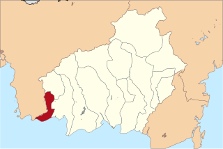
Sukamara Regency is one of the thirteen regencies which comprise the Central Kalimantan Province on the island of Kalimantan (Borneo), Indonesia. It was created on 10 April 2002 from the former southwest part of West Kotawaringin Regency. The town of Sukamara is the capital of Sukamara Regency, which covers an area of 3,827 km2. The population of the Regency was 44,952 at the 2010 Census and 63,464 at the 2020 Census; the official estimate as at mid 2023 was 66,633.

Seruyan Regency is one of the thirteen regencies which comprise the Central Kalimantan Province on the island of Kalimantan (Borneo), Indonesia. It was created on 10 April 2002 from what were previously the western districts of East Kotawaringin Regency. The town of Kuala Pembuang in Seruyan Hilir District is the capital of Seruyan Regency. The population of the Regency was 139,931 at the 2010 Census and 162,906 at the 2020 census; the official estimate was at mid 2023 was 171,304.