Ventura, officially named San Buenaventura, is a city in and the county seat of Ventura County, California, United States. The population was 110,763 at the 2020 census. Ventura is a popular tourist destination, owing to its historic landmarks, beaches, and resorts.

The Santa Clara River is an 83 mi (134 km) long river in Ventura and Los Angeles counties in Southern California. It drains parts of four ranges in the Transverse Ranges System north and northwest of Los Angeles, then flows west onto the Oxnard Plain and into the Santa Barbara Channel of the Pacific Ocean.

The Santa Susana Pass, originally Simi Pass, is a low mountain pass in the Simi Hills of Southern California, connecting the San Fernando Valley and Los Angeles neighborhood of Chatsworth, to the city of Simi Valley and eponymous valley.
La Conchita is a small unincorporated community in western Ventura County, California, on U.S. Route 101 just southeast of the Santa Barbara county line. The ZIP Code is 93001, and the community is inside area code 805.

San Onofre State Beach is a 3,000-acre (1,214 ha) state park in San Diego County, California. The beach is 3 miles (5 km) south of San Clemente on Interstate 5 at Basilone Road. The state park is leased to the state of California by the United States Marine Corps. Governor Ronald Reagan established San Onofre State Beach in 1971. With over 2.5 million visitors per year, it is one of the five most-visited state parks in California, hosting swimmers, campers, kayakers, birders, fishermen, bicyclists, sunbathers, surfers, and the sacred Native American site of Panhe.

Leo Carrillo State Park is a state park in Los Angeles County, California, United States. Situated along the Malibu coast, the park is a component of Santa Monica Mountains National Recreation Area. With 1.5 miles (2.4 km) of beach, the parkland stretches into the Santa Monica Mountains. The park has expanded into Ventura County and also includes management of County Line Beach. California State Route 1 runs through the park, where it intersects with the western terminus of the Mulholland Highway. The 2,513-acre (1,017 ha) park was established in 1953. It is named for actor and conservationist Leo Carrillo (1880–1961), who served on the State Parks commission.

The Santa Monica Mountains National Recreation Area is a United States national recreation area containing many individual parks and open space preserves, located primarily in the Santa Monica Mountains of Southern California. The SMMNRA is in the greater Los Angeles region, with two thirds of the parklands in northwest Los Angeles County, and the remaining third, including a Simi Hills extension, in southeastern Ventura County.

El Capitán State Beach is a protected beach in the state park system of California. The most easterly of three state parks along the Gaviota Coast, it is located about 20 miles (32 km) west of downtown Santa Barbara, in Santa Barbara County. The beach is named for José Francisco Ortega, who retired from the Spanish Army in 1795 with the rank of captain and received the Rancho Nuestra Señora del Refugio as a land grant.
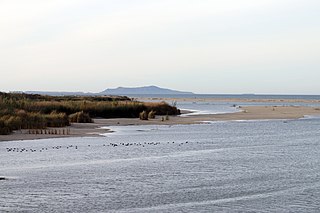
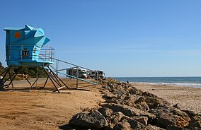
McGrath State Beach is a protected beach park located on the south bank of the mouth of Santa Clara River in the city of Oxnard, California. McGrath State Beach is one of the best bird-watching areas in California, with the lush riverbanks of the Santa Clara River and sand dunes along the shore. A nature trail leads to the Santa Clara Estuary Natural Preserve. Camping sites are available. Two miles of beach provide surfing and fishing opportunities. Just south of the station is the undeveloped Mandalay Beach Park which is about a mile downcoast beach walk from the park or a bike ride along Harbor Blvd. Located south of Ventura on Harbor Boulevard, the beach is on the Pacific Coast Bicycle Route and the California Coastal Trail.

Harry Chandler was an American newspaper publisher and investor who became owner of the largest real estate empire in the United States.

Ventura station is a passenger rail station in downtown Ventura, California. The station is served by Amtrak's Pacific Surfliner from San Luis Obispo to San Diego. Ten Pacific Surfliner trains serve the station daily. Of the 73 California stations served by Amtrak, Ventura was the 33rd-busiest in FY2010, boarding or detraining an average of approximately 125 passengers daily. The single platform is located on the south side of the tracks with a view of the Santa Barbara Channel and the Channel Islands. The Ventura Freeway is parallel with and on the north side of tracks.

Aliso Creek is a 19.8-mile (31.9 km)-long, mostly urban stream in south Orange County, California. Originating in the Cleveland National Forest in the Santa Ana Mountains, it flows generally southwest and empties into the Pacific Ocean at Laguna Beach. The creek's watershed drains 34.9 square miles (90 km2), and it is joined by seven main tributaries. As of 2018, the watershed had a population of 144,000 divided among seven incorporated cities.
Rancho Cañada de San Miguelito was a 8,877-acre (35.92 km2) Mexican land grant in present-day Ventura County, California, given in 1846 by Governor Pío Pico to Ramón Rodríguez. The name means valley of San Miguelito. The grant extended between the Pacific coast and the west bank of the Ventura River. On the east bank of the Ventura River was Rancho Cañada Larga o Verde and to the south was Rancho San Miguel, Rancho Ex-Mission San Buenaventura, and present day Ventura.
Seaside Park is an event venue in Ventura, California, United States. The 62-acre site (25 ha) is the home of the Ventura County Fair. Trade shows, concerts, and other events are held throughout the year at the fairgrounds. The beachfront site, near the mouth of the Ventura River, also includes Surfers' Point, known for its point break that produces distinctive waves.
The Sherpa Fire was a wildfire that burned in the Santa Ynez Mountains along the Gaviota Coast in the southwestern part of Santa Barbara County, California in June 2016. In a matter of hours the fire spread to over 1,400 acres (570 ha) as the fire was propelled by downslope sundowner winds. This offshore northerly wind contrasts with the more typical onshore flow and sent the fire down the canyons towards the ocean with gusts of over 35 miles per hour (56 km/h). The wildfire resulted in evacuations at two state beach campgrounds and some residences together with intermittent interruption of traffic on a state transportation route.

The Ventura Pier, formerly known as the Ventura Wharf and the San Buenaventura Wharf, is a wooden pier located on the Pacific Ocean in Ventura, California. The pier has been designated as Ventura Historic Landmark No. 20. It is the oldest pier in California.

Eugene Preston Foster, commonly known as E. P. Foster, was a rancher, entrepreneur, banker, and philanthropist in Ventura County, California.
The Gaviota Coast in Santa Barbara County, California is a rural coastline along the Santa Barbara Channel roughly bounded by the city of Goleta on the south and the north boundary of the county on the north. This last undeveloped stretch of Southern California coastline consists of dramatic bluffs, isolated beaches and terraced grasslands.

Stephen Bennett is an American activist, educator, and politician serving as a member of the California State Assembly from the 38th district as a member of the Democratic Party. Prior to his tenure in the state legislature, he was active in local politics in Ventura, California, and Ventura County, California, with him serving on the city council and board of supervisors.