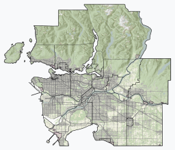
Vancouver is a major city in western Canada, located in the Lower Mainland region of British Columbia. As the most populous city in the province, the 2021 Canadian census recorded 662,248 people in the city, up from 631,486 in 2016. The Metro Vancouver area had a population of 2.6 million in 2021, making it the third-largest metropolitan area in Canada. Greater Vancouver, along with the Fraser Valley, comprises the Lower Mainland with a regional population of over 3 million. Vancouver has the highest population density in Canada, with over 5,700 people per square kilometre, and fourth highest in North America.

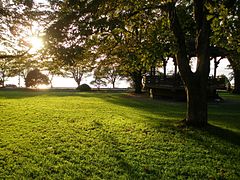
Stanley Park is a 405-hectare (1,001-acre) public park in British Columbia, Canada, that makes up the northwestern half of Vancouver's Downtown peninsula, surrounded by waters of Burrard Inlet and English Bay. The park borders the neighbourhoods of West End and Coal Harbour to its southeast, and is connected to the North Shore via the Lions Gate Bridge. The historic lighthouse on Brockton Point marks the park's easternmost point. While it is not the largest urban park, Stanley Park is about one-fifth larger than New York City's 340-hectare (840-acre) Central Park and almost half the size of London's 960-hectare (2,360-acre) Richmond Park.

The West End is a neighbourhood in Vancouver, British Columbia, Canada, located between the Coal Harbour neighbourhood and the financial and central business districts of Downtown Vancouver to the east, Stanley Park to the northwest, the English Bay to the west, and Kitsilano to the southwest across the False Creek opening.

Kitsilano is a neighbourhood located in the city of Vancouver, British Columbia, Canada. Kitsilano is named after Squamish chief August Jack Khatsahlano, and the neighbourhood is located in Vancouver's West Side along the south shore of English Bay, between the neighbourhoods of West Point Grey and Fairview. The area is mostly residential with two main commercial areas, West 4th Avenue and West Broadway, known for their retail stores, restaurants and organic food markets.

Burrard Inlet is a relatively shallow-sided fjord in northwestern Lower Mainland, British Columbia, Canada. Formed during the last Ice Age, it separates the City of Vancouver and the rest of the lowland Burrard Peninsula to the south from the coastal slopes of the North Shore Mountains, which span West Vancouver and the City and District of North Vancouver to the north.

False Creek is a short narrow inlet in the heart of Vancouver, separating the Downtown and West End neighbourhoods from the rest of the city. It is one of the four main bodies of water bordering Vancouver, along with English Bay, Burrard Inlet, and the Fraser River. Granville Island is located within the inlet.

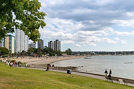
Sunset Beach is an urban beach park on English Bay situated in the West End neighbourhood of Vancouver, British Columbia, Canada. It is part of the city seawall system and is bisected by a multi-use path for bicycling, walking, and skating that connects to the adjacent Vancouver Aquatic Centre and Burrard Street Bridge. The park is maintained by the city government and includes public washrooms, concession stands, an off-leash area for dogs, and a False Creek Ferries dock. Between May and September, lifeguards are posted at the beach.

The Burrard Street Bridge is a four-lane, Art Deco style, steel truss bridge constructed in 1930–1932 in Vancouver, British Columbia, Canada. The high, five part bridge on four piers spans False Creek, connecting downtown Vancouver with Kitsilano via connections to Burrard Street on both ends. It is one of three bridges crossing False Creek. The other two bridges are the Granville Bridge, three blocks or 0.5 km (0.31 mi) to the southeast, and the Cambie Street Bridge, about 11 blocks or 2 km (1.2 mi) to the east. In addition to the vehicle deck, the Burrard Bridge has 2.6 m wide sidewalks and a dedicated cycling lanes on both sides.
Kitsilano Beach is one of the most popular beaches in Vancouver, especially in the warm summer months. Located at the north edge of the Kitsilano neighbourhood, the beach faces out onto English Bay.

Downtown Vancouver is the central business district and the city centre neighbourhood of Vancouver, Canada, on the northwestern shore of the Burrard Peninsula in the Lower Mainland region of British Columbia. It occupies most of the north shore of the False Creek inlet, which cuts into the Burrard Peninsula creating the Downtown Peninsula, where the West End neighbourhood and Stanley Park are also located.
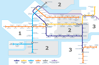
Transportation in Vancouver, British Columbia, has many of the features of modern cities worldwide. Unlike many large metropolises, Vancouver has no freeways into or through the downtown area. A proposed freeway through the downtown was rejected in the 1960s by a coalition of citizens, community leaders and planners. This event "signalled the emergence of a new concept of the urban landscape" and has been a consistent element of the city's planning ever since.

The history of Vancouver, British Columbia, is one that extends back thousands of years, with its first inhabitants arriving in the area following the Last Glacial Period. With its location on the western coast of Canada near the mouth of the Fraser River and on the waterways of the Strait of Georgia, Howe Sound, Burrard Inlet, and their tributaries, Vancouver has – for thousands of years – been a place of meeting, trade, and settlement.
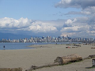
Spanish Banks are a series of beaches in the city of Vancouver, British Columbia, Canada, located along the shores of English Bay in the West Point Grey neighbourhood. Spanish Banks is located between Locarno Beach to the east and the grounds of the University of British Columbia to the west.
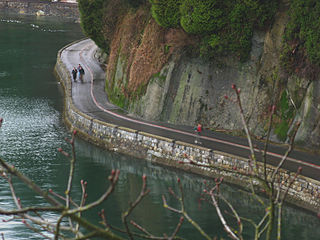
The seawall in Vancouver, British Columbia, Canada, is a stone wall that was constructed around the perimeter of Stanley Park to prevent erosion of the park's foreshore. Colloquially, the term also denotes the pedestrian, bicycle, and rollerblading pathway on the seawall, one which has been extended far outside the boundaries of Stanley Park and which has become one of the most-used features of the park by both locals and tourists. James "Jimmy" Cunningham, a master mason, dedicated his life to the construction of the seawall from 1931 until his retirement. Even after he retired, Cunningham continued to return to monitor the wall's progress, until his death at 85. While the whole path is not built upon the seawall, the total distance from CRAB park, around Stanley Park and False Creek to Spanish Banks is about 30 kilometres (19 mi).

False Creek Ferries, a division of Granville Island Ferries Ltd, is a privately owned and operated ferry service that operates on False Creek near downtown Vancouver, British Columbia, Canada. The False Creek Ferry fleet has grown from the four electric ferries that formed the company to a fleet that now consists of 17 ferries divided into three classes; the 20-passenger Balfry class, the 12-passenger Spirit class, and the open-deck Novel class. The service operates every day of the year, except Christmas Day and Boxing Day.

Sen̓áḵw or sən̓aʔqʷ, rendered in English as Snawk, Snawq, Sneawq, or Snawkw, is a village site of the Indigenous Squamish people, located near what is now known as the Kitsilano neighbourhood of Vancouver, British Columbia, Canada. In 1869 the Colonial Government set aside land around the village, and in 1877 the Joint Reserve Commission established by the Provincial and Federal Governments to deal with land allotments to indigenous people in B.C., expanded the area set aside to approximately 80 acres (32 ha) as False Creek Indian Reserve No. 6 or more popularly the Kitsilano Indian Reserve. The village site was home for many Squamish, but after further settlement began in the Vancouver area, the inhabitants were forced to relocate to other nearby villages. This village was also the home of August Jack Khatsahlano, a prominent chief of the Squamish and a notable Vancouver historian on local Indigenous history.
The Vancouver Greenway Network is a collection of greenways across Vancouver, British Columbia, Canada. Greenways are streets where pedestrians and cyclists are prioritized over motorized vehicles, through structures such as road closures and road diverters to prevent or limit motor vehicle traffic, widened sidewalk-promenades, narrowed road space, speed restrictions, bike lanes, raised sidewalks and speed bumps. The City of Vancouver hopes to create and maintain the trend of constructing new greenways to establish a network where, potentially, every citizen could access a city greenway within a 25-minute walking or a 10-minute cycling distance of their home.

Kitsilano Pool is an outdoor saltwater swimming pool, located at Kitsilano Beach in Vancouver, British Columbia, Canada. At 137 metres long, it is the longest outdoor swimming pool in North America.
Marine Drive is the name for three major roadways in Greater Vancouver, British Columbia, Canada. The roads are known for running parallel to major bodies of water, with some sections being a major arterial road, while other serve local traffic. Marine Way is the name applied to a section of Marine Drive that was bypassed in the early 1980s.