Freeport, Nova Scotia

Last updated

Freeport
Village
Canada Nova Scotia location map 2.svg
Red pog.svg
Freeport
Location of Freeport, Nova Scotia
Coordinates: 44°16′27″N66°19′18″W / 44.27417°N 66.32167°W / 44.27417; -66.32167 Coordinates: 44°16′27″N66°19′18″W / 44.27417°N 66.32167°W / 44.27417; -66.32167
CountryFlag of Canada (Pantone).svg  Canada
ProvinceFlag of Nova Scotia.svg  Nova Scotia
County Digby
Municipality Digby
Founded1784
Area
  Total7.57 km2 (2.92 sq mi)
Highest elevation
5 m (16 ft)
Lowest elevation
0 m (0 ft)
Population
 (2021)
  Total217
  Density28.7/km2 (74/sq mi)
Time zone UTC-4 (AST)
  Summer (DST) UTC-3 (ADT)
Canadian Postal code
B0V 1B0
Area code 902
Telephone Exchange 839
NTS Map021B08
GNBC CodeCAMZW
Websitewww.freeportnovascotia.ca

Freeport is a village in Digby County, Nova Scotia and it is located on Long Island in the Bay of Fundy.

Contents

At the end of Digby Neck on Long Island, Freeport is a working fishing village nestled around tidal basin. This area is great for bird watching, beach combing, hiking trails, birds, whale watching, gift shops, accommodations, restaurants, and unique flora and fauna.

History

Loyalists founded Freeport in 1784 establishing fishing and trading industries. Prior to this it had been inhabited by the Mi'kmaq First Nation.

Place names such as Petit Passage, Grand Passage and the Saint Mary’s Bay can be attributed to the French explorer, Samuel de Champlain, who first visited the area in 1604. However, the village itself was most likely named for Freeport, Maine, or because the water of and surrounding the harbour does not freeze during winter due to extreme tidal fluctuations, making it free from ice. [1] Well known Black Loyalist, Rose Fortune is believed to have lived here in 1795, giving birth to one of her children. [2]

Demographics

In the 2021 Census of Population conducted by Statistics Canada, Freeport had a population of 217 living in 113 of its 138 total private dwellings, a change of

The community is the final destination of Brad Pitt in the movie World War Z (2013), although this scene was not filmed in Freeport, but Lulworth Cove in the UK.

Related Research Articles

<span class="mw-page-title-main">Hants County, Nova Scotia</span> County in Nova Scotia, Canada

Hants County is an historical county and census division of Nova Scotia, Canada. Local government is provided by the West Hants Regional Municipality, and the Municipality of the District of East Hants.

<span class="mw-page-title-main">Annapolis County, Nova Scotia</span> County in Nova Scotia, Canada

Annapolis County is a county in the Canadian province of Nova Scotia located in the western part of the province located on the Bay of Fundy. The county seat is Annapolis Royal.

<span class="mw-page-title-main">Digby County, Nova Scotia</span> County in Nova Scotia, Canada

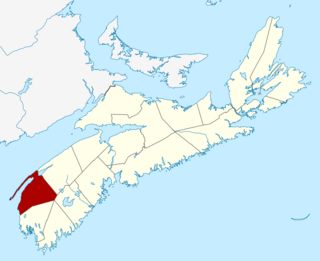
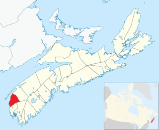
Digby County is a county in the Canadian province of Nova Scotia.

<span class="mw-page-title-main">Guysborough County, Nova Scotia</span> County in Nova Scotia, Canada

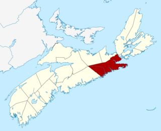
Guysborough County is a county in the Canadian province of Nova Scotia.

<span class="mw-page-title-main">Inverness County, Nova Scotia</span> County in Nova Scotia, Canada

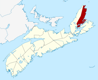
Inverness County is an historical county and census division of Nova Scotia, Canada. Local government is provided by the Municipality of the County of Inverness, the town of Port Hawkesbury and the Whycocomagh 2 Waycobah First Nation reserve.

<span class="mw-page-title-main">Victoria County, Nova Scotia</span> County in Nova Scotia, Canada

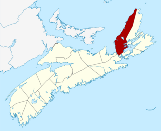
Victoria County is an historical county and census division of Nova Scotia, Canada. Local government is provided by the Municipality of the County of Victoria and the Wagmatcook 1 reserve.

<span class="mw-page-title-main">Baddeck</span> Village in Nova Scotia, Canada

Baddeck is a village in northeastern Nova Scotia, Canada. It is situated in the centre of Cape Breton, approximately 6 km east of where the Baddeck River empties into Bras d'Or Lake.

Havre Boucher is a community in Antigonish County, Nova Scotia, Canada.

<span class="mw-page-title-main">Digby, Nova Scotia</span> Town in Nova Scotia, Canada

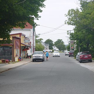
Digby is an incorporated town in southwestern Nova Scotia, Canada. It is in the historical county of Digby and a separate municipality from the Municipality of the District of Digby. The town is situated on the western shore of the Annapolis Basin near the entrance to the Digby Gut, which connects the basin to the Bay of Fundy.

<span class="mw-page-title-main">Westport, Nova Scotia</span>

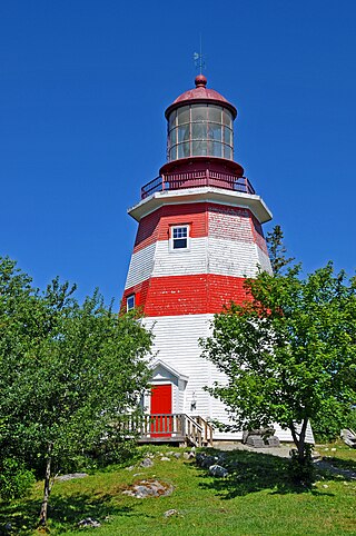
Westport, Nova Scotia is a village in Digby County, Nova Scotia and it is located on Brier Island in the Bay of Fundy. As of 2021, the population was 193.

Brier Island is an island in the Bay of Fundy in Digby County, Nova Scotia.

<span class="mw-page-title-main">Annapolis Royal</span> Town in Nova Scotia, Canada

Annapolis Royal, formerly known as Port Royal, is a town located in the western part of Annapolis County, Nova Scotia, Canada.

<span class="mw-page-title-main">Municipality of the District of Clare</span> District municipality in Nova Scotia, Canada

Clare, officially named the Municipality of the District of Clare, is a district municipality in western Nova Scotia, Canada. Statistics Canada classifies the district municipality as a municipal district.

<span class="mw-page-title-main">Municipality of the District of Barrington</span> District municipality in Nova Scotia, Canada

Barrington, officially named the Municipality of the District of Barrington, is a district municipality in western Shelburne County, Nova Scotia, Canada. Statistics Canada classifies the district municipality as a municipal district.

<span class="mw-page-title-main">Municipality of the District of Shelburne</span> District municipality in Nova Scotia, Canada

District of Shelburne, officially named the Municipality of the District of Shelburne, is a district municipality comprising the eastern section of Shelburne County, Nova Scotia, Canada, but does not include the Towns of Shelburne or Lockeport. Statistics Canada classifies the district municipality as a municipal district. It is home to the Bowers Meadows Wilderness Area.

<span class="mw-page-title-main">Lockeport</span> Town in Nova Scotia, Canada

Lockeport is a town and port in Shelburne County, Nova Scotia, Canada. It is a traditional Nova Scotian fishing town, situated on a peninsula in Allendale Bay. It is connected to the mainland by the Crescent Beach causeway. The area that surrounds the bay is known as the "Ragged Islands."

<span class="mw-page-title-main">Mulgrave, Nova Scotia</span> Town in Nova Scotia, Canada

Mulgrave is a town on the Strait of Canso in Guysborough County, Nova Scotia, Canada. Located along the Marine Drive, Route 344 traverses the community. The town's current name was adopted in 1859 to honour the colonial Lieutenant Governor, the Earl of Mulgrave. Lying opposite to the town of Port Hawkesbury, the community is located along the western shore of the Canso Strait. It was established as McNair's Cove in the early 19th century, and the name Port Mulgrave was adopted in 1859, later shortening to its current form. The early industry of the community relied on ferry service between the Nova Scotia mainland and Cape Breton Island. Ferry service began in the 1810s and rail service reached the area in the 1880s. The ferry services lasted until the opening of the Canso Causeway in 1955, dealing a major blow to the local economy. As of 2016, Mulgrave has a population of 722 and a population density of 40.5/km2 (104.9/sq mi), within an area of 17.83 km2 (6.88 sq mi).

<span class="mw-page-title-main">Guysborough, Nova Scotia (community)</span> Village in Nova Scotia, Canada

Guysborough is an unincorporated Canadian community in Guysborough County, Nova Scotia.

<span class="mw-page-title-main">Long Island (Nova Scotia)</span>

Long Island is a Canadian island in Digby County, Nova Scotia.

<span class="mw-page-title-main">Municipality of the District of Digby</span> District municipality in Nova Scotia, Canada

Digby, officially named the Municipality of the District of Digby, is a district municipality in Digby County, Nova Scotia, Canada. Statistics Canada classifies the district municipality as a municipal district.

References

  1. Hamiton, William Baillie (1996). Place Names of Atlantic Canada (illustrated, reprint ed.). University of Toronto Press. ISBN   0802075703 . Retrieved 31 August 2017.
  2. Thompson, Brenda J (2019). Finding Fortune: Documenting and Imagining the LIfe of Rose Fortune (1774-1864). Halifax, Nova Scotia: SSP Publications. pp. 78–79. ISBN   978-1-989347-04-1.
  3. "Population and dwelling counts: Canada and designated places". Statistics Canada. February 9, 2022. Retrieved May 9, 2022.