A town is a type of municipality in the Canadian Province of Nova Scotia. Towns are incorporated by order by the Nova Scotia Utility and Review Board pursuant to sections 383 through 388 of Nova Scotia's Municipal Government Act. [1]
Nova Scotia had 26 towns at the time of the 2016 Census. In 2016, the towns had a cumulative population of 97,495. Nova Scotia's largest and smallest towns are Truro and Annapolis Royal with populations of 12,261 and 491 respectively.
Incorporation date [2] | 2016 Census of Population [3] | |||||
---|---|---|---|---|---|---|
Population (2016) | Population (2011) | Change | Land area (km²) | Population density | ||
Amherst | December 18, 1889 | style="text-align:center;"|9,413 | 9,717 | −3.1% | 12.07 | 779.9/km2 |
Annapolis Royal | November 29, 1892 | style="text-align:center;"|491 | 481 | +2.1% | 2.04 | 240.7/km2 |
Antigonish | January 9, 1889 | style="text-align:center;"|4,364 | 4,524 | −3.5% | 5.01 | 871.1/km2 |
Berwick | May 25, 1923 [4] | style="text-align:center;"|2,509 | 2,454 | +2.2% | 6.58 | 381.3/km2 |
Bridgewater | February 13, 1899 | style="text-align:center;"|8,532 | 8,241 | +3.5% | 13.63 | 626.0/km2 |
Clark's Harbour | March 4, 1919 | style="text-align:center;"|758 | 820 | −7.6% | 2.81 | 269.8/km2 |
Digby | December 18, 1890 | style="text-align:center;"|2,060 | 2,152 | −4.3% | 3.15 | 654.0/km2 |
Kentville | May 1, 1886 | style="text-align:center;"|6,271 | 6,094 | +2.9% | 17.26 | 363.3/km2 |
Lockeport | February 26, 1907 | style="text-align:center;"|531 | 588 | −9.7% | 2.33 | 227.9/km2 |
Lunenburg | October 29, 1888 | style="text-align:center;"|2,263 | 2,313 | −2.2% | 4.04 | 560.1/km2 |
Mahone Bay | March 31, 1919 | style="text-align:center;"|1,036 | 943 | +9.9% | 3.12 | 332.1/km2 |
Middleton | May 31, 1909 | style="text-align:center;"|1,832 | 1,749 | +4.7% | 5.57 | 328.9/km2 |
Mulgrave | December 1, 1923 | style="text-align:center;"|722 | 794 | −9.1% | 17.83 | 40.5/km2 |
New Glasgow | May 6, 1875 | style="text-align:center;"|9,075 | 9,562 | −5.1% | 9.96 | 911.1/km2 |
Oxford | April 19, 1904 | style="text-align:center;"|1,190 | 1,151 | +3.4% | 10.76 | 110.6/km2 |
Pictou | May 4, 1874 | style="text-align:center;"|3,186 | 3,437 | −7.3% | 8.01 | 397.8/km2 |
Port Hawkesbury | January 22, 1889 | style="text-align:center;"|3,214 | 3,366 | −4.5% | 8.1 | 396.8/km2 |
Shelburne | April 4, 1907 [5] | style="text-align:center;"|1,743 | 1,686 | +3.4% | 8.84 | 197.2/km2 |
Stellarton | October 22, 1889 | style="text-align:center;"|4,208 | 4,485 | −6.2% | 8.99 | 468.1/km2 |
Stewiacke | August 30, 1906 | style="text-align:center;"|1,373 | 1,438 | −4.5% | 17.62 | 77.9/km2 |
Trenton | March 18, 1911 | style="text-align:center;"|2,474 | 2,616 | −5.4% | 6.07 | 407.6/km2 |
Truro | May 6, 1875 | style="text-align:center;"|12,261 | 12,059 | +1.7% | 34.49 | 355.5/km2 |
Westville | August 20, 1894 | style="text-align:center;"|3,628 | 3,798 | −4.5% | 14.23 | 255.0/km2 |
Wolfville | March 4, 1893 | style="text-align:center;"|4,195 | 4,269 | −1.7% | 6.46 | 649.4/km2 |
Yarmouth | August 6, 1890 | style="text-align:center;"|6,518 | 6,761 | −3.6% | 10.57 | 616.7/km2 |
Total | — | 97,495 | 99,283 | −1.8% | 248.65 | 392.1/km2 |
Province of Nova Scotia | — | 923,598 | 921,727 | +0.2% | 52,942.27 | 17.45/km2 |
Name | Dissolution date | Population (2011) [6] | Population (2006) [6] | Change (%) [6] | Area (km2) [6] | Population density [6] |
---|---|---|---|---|---|---|
Bedford | April 1, 1996 [7] | 23,019 | 16,601 | 38.7 | ||
Bridgetown | April 1, 2015 [8] | 949 | 972 | −2.4 | 3.54 | 267.8 |
Canso | July 1, 2012 [8] | 806 | 911 | −11.5 | 5.42 | 148.8 |
Dominion | April 1, 1995 [7] | 1,193 | 2,022 | −3.4 | ||
Glace Bay | April 1, 1995 [7] | 19,076 | 19,968 | −4.7 | 35.15 | 542.7 |
Hantsport | July 1, 2015 [8] | 1,159 | 1,191 | −2.7 | 2.13 | 544.6 |
Inverness | [ citation needed ] | 1,387 | 1,464 | −5.5 | ||
Joggins | 1949 [9] | |||||
Liverpool | April 1, 1996 [7] | 2,653 | 2,759 | −3.8 | 3.48 | 761.6 |
Louisbourg | April 1, 1995 [7] | 946 | 988 | −4.3 | 3.3 | 286.8 |
New Waterford | April 1, 1995 [7] | 8,942 | 9,661 | −7.4 | 20.81 | 429.7 |
North Sydney | April 1, 1995 [7] | 6,048 | 6,552 | −7.7 | ||
Parrsboro | November 1, 2016 [10] | 1,305 | 1,401 | −6.9 | 14.88 | 87.7 |
Port Hood | August 1946 [11] | |||||
Springhill | April 1, 2015 [8] | 3,868 | 3,941 | −1.9 | 11.15 | 346.8 |
Sydney Mines | April 1, 1995 [7] | 14,135 | 15,500 | −9.6 | ||
Wedgeport | December 22, 1947 [12] | 1,180 | 1,207 | −2.2 | 9.72 | 121.4 |
Windsor | April 1, 2020 | 3,648 | 3,785 | +3.8% | 9.11 | 400.4/km2 |
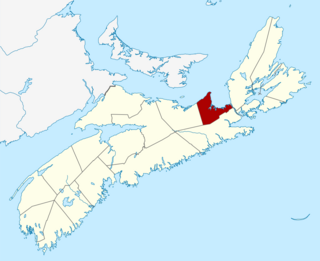
Colchester County is a county in the Canadian province of Nova Scotia. With a population of 50,585 the county is the fourth largest in Nova Scotia. Colchester County is located in north central Nova Scotia.
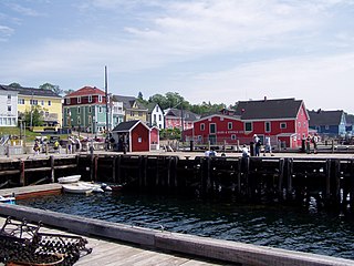
Lunenburg County is an historical county and census division on the South Shore of the Canadian province of Nova Scotia. Major settlements include Bridgewater, Lunenburg, and Mahone Bay.
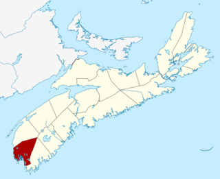
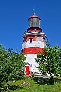
Yarmouth County is a rural county in the Canadian province of Nova Scotia. It has both traditional Anglo-Scottish and Acadian French culture as well as significant inland wilderness areas, including over 365 lakes and several major rivers. It comprises three municipalities: the Town of Yarmouth, the Municipality of the District of Yarmouth, and the Municipality of the District of Argyle.
Port Hawkesbury is a municipality in southern Cape Breton Island, Nova Scotia, Canada. While within the historical county of Inverness, it is not part of the Municipality of Inverness County.
The Municipality of the District of Lunenburg, is a district municipality in Lunenburg County, Nova Scotia, Canada. Statistics Canada classifies the district municipality as a municipal district.
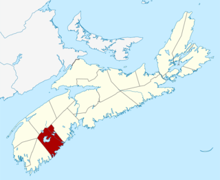
Argyle, officially named the Municipality of the District of Argyle, is a district municipality in Yarmouth County, Nova Scotia. Statistics Canada classifies the district municipality as a municipal district.
Barrington, officially named the Municipality of the District of Barrington, is a district municipality in western Shelburne County, Nova Scotia, Canada. Statistics Canada classifies the district municipality as a municipal district.
The Region of Queens Municipality is a regional municipality in southwestern Nova Scotia, Canada. It is the northern gateway of the UNESCO Southwest Nova Biosphere Reserve, a centre of outdoor activities. Campgrounds at Kejimukujik National Park and National Historic Site, Thomas H. Raddall Provincial Park, and several other locations offer hiking, biking, canoeing, kayaking, cross-country skiing and snowshoeing. Its seacoast and inland areas are popular photo locations.
District of Shelburne, officially named the Municipality of the District of Shelburne, is a district municipality comprising the eastern section of Shelburne County, Nova Scotia, Canada, but does not include the Towns of Shelburne or Lockeport. Statistics Canada classifies the district municipality as a municipal district. It is home to the Bowers Meadows Wilderness Area.
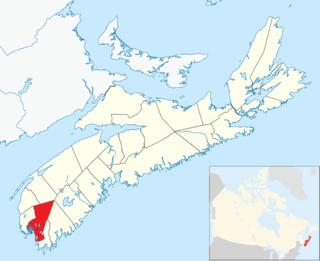
Yarmouth, officially named the Municipality of the District of Yarmouth, is a district municipality in Yarmouth County, Nova Scotia, Canada. Statistics Canada classifies the district municipality as a municipal district.
Mackenzie County is a specialized municipality in northern Alberta, Canada. It is located in Census Division 17, along the Mackenzie Highway. Mackenzie County municipal office is located in the Hamlet of Fort Vermilion.
St. Mary's, officially named the Municipality of the District of St. Mary's, is a district municipality in Guysborough County, Nova Scotia, Canada. Statistics Canada classifies the district municipality as a municipal district.
Guysborough, officially named the Municipality of the District of Guysborough, is a district municipality in Guysborough County, Nova Scotia, Canada. Statistics Canada classifies the district municipality as a municipal district.
Meadowbank, previously Meadow Bank, is a former rural municipality in the Canadian province of Prince Edward Island within Queens County.
Canada has a total of 3,573 municipalities among its 10 provinces and 3 territories that are subject to some form of local government.
Antigonish County is an historical county and census division of Nova Scotia, Canada. Local government is provided by the Municipality of the County of Antigonish, the Town of Antigonish, and by two reserves: Pomquet and Afton 23, and Summerside 38.
It was incorporated as a town on April 4, 1907.