Related Research Articles
The Chestatee River is a 32.76-mile-long (52.72 km) river in the Appalachian Mountains of northern Georgia, USA.
Eastanollee is an unincorporated community in Stephens County, in the U.S. state of Georgia.

The Withlacoochee River originates in Georgia, northwest of Nashville, Georgia. It flows south through Berrien County where it joins the New River and forms part of the boundary between Berrien and Cook counties. It then flows south into Lowndes County, Georgia. At Troupville, Georgia the Little River joins the Withlacoochee River flows continues to flow south and forms part of the boundary between Lowndes and Brooks counties in Georgia. The river then flows into Florida for 1.34 miles Florida before returning into Georgia for an additional 2.44 miles. It then returns to Florida, forming the northeast boundary of Madison County, Florida and the western boundary of Hamilton County, Florida and eventually merges with the Suwannee at Suwannee River State Park west of Live Oak. The river is 115 miles (185 km) long. It is believed to be the source for the name of the central Florida river of the same name.
Tugaloo was a Cherokee town on the Tugaloo River, at the mouth of Toccoa Creek, near present-day Toccoa, Georgia and Travelers Rest in Stephens County, Georgia.

The waterfalls of northern Georgia, U.S., are a prominent feature of the geography of that region, as well as a major focus of tourism and outdoor recreation. Many are located in state parks, national forests, wildlife management areas, and other public lands. Many are accessible—with varying degrees of ease or difficulty—via established hiking trails, and some developed areas include boardwalks, observation platforms, picnic areas, and other amenities. The Cherokee called this region "Land of a Thousand Waterfalls". The third-, fourth-, and fifth-highest waterfalls in the eastern United States are located in northern Georgia.

Assumption is a small unincorporated community and also a historically Irish (Catholic) community in southern Amboy Township, Fulton County, Ohio, United States. A part of the Toledo Metropolitan Area, it lies seven miles from the northern edge of Swanton. It is located at roughly 41°40'N, 83°55'W.
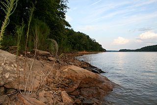
Camp Creek is a 14.1-mile-long (22.7 km) tributary of the Chattahoochee River in Fulton County, Georgia. Rising in College Park, the creek flows west to join the Chattahoochee northeast of Campbellton.
The Mulberry River is a 28.2-mile-long (45.4 km) tributary of the Middle Oconee River in the U.S. state of Georgia. It rises in southeastern Hall County (Braselton) and flows southeast, forming the boundary between Jackson and Barrow counties, to join the Middle Oconee south of Jefferson.

The Willacoochee River is a 21.5-mile-long (34.6 km) tributary of the Alapaha River in the U.S. state of Georgia. Via the Alapaha and Suwannee rivers, its waters flow to the Gulf of Mexico.

Neels Gap is a divide along the Blue Ridge Mountains at the base of the Frogtown Creek in the counties of Union and Lumpkin in the U.S. state of Georgia. The divide is located approximately 14.5 miles (23.3 km) northeast of Dahlonega.

Huron is an unincorporated community in Spice Valley Township, Lawrence County, in the U.S. state of Indiana.
Bradysville is an unincorporated community in Adams County, in the U.S. state of Ohio.

Dicks Creek is a stream in Georgia, and is a tributary of the Chestatee River. The creek is approximately 7.37 miles (11.86 km) long.
Tate Creek is a stream in Georgia, and is a tributary of the Chestatee River. The creek is approximately 3.97 miles (6.39 km) long.
Hamilton Creek is a tributary stream of Cahuilla Creek,, in Riverside County, California. Its mouth is found in the Anza Valley at an elevation of 3,865 feet (1,178 m). Its source is at 33°32′46″N116°34′36″W at an elevation of 4,800 feet on the southwest facing slope of Lookout Mountain in the Santa Rosa Mountains.
Bad Creek is a stream in the U.S. state of Georgia. It is a tributary to the Chattooga River.
Mossy Creek is an unincorporated community in White County, in the U.S. state of Georgia.
Parkertown is an unincorporated community in Hart County, in the U.S. state of Georgia.
Piscola is an unincorporated community in Thomas County, in the U.S. state of Georgia.
Tesnatee is an unincorporated community in White County, in the U.S. state of Georgia.
References
- ↑ U.S. Geological Survey Geographic Names Information System: Frogtown Creek
- ↑ "The Names Stayed". Calhoun Times and Gordon County News. August 29, 1990. p. 64. Retrieved 29 April 2015.
- ↑ Krakow, Kenneth K. (1975). Georgia Place-Names: Their History and Origins (PDF). Macon, GA: Winship Press. p. 89. ISBN 0-915430-00-2.
Coordinates: 34°40′14″N83°54′42″W / 34.67056°N 83.91167°W
| This article related to a river in the US state of Georgia is a stub. You can help Wikipedia by expanding it. |